Showing posts with label Wellington. Show all posts

Saturday, January 4, 2025

Wellington Street Part 12: 50 Years of Rapid Transit in Ottawa

Part 12: 50 Years of Rapid Transit in Ottawa

   [Show/Hide Contents]

I wanted to pick up the narrative of Wellington Street to line up with an important milestone in Ottawa transit history: the 50th anniversary of bus lanes in Ottawa. It doesn't involve much in the way of the theme of this blog series—the connections, disconnections, and renamings of Wellington Street—but there is a dash of that. Alas, I missed the 50th anniversary for this blog post (by over a year!) but I did get a September 2023 article on the topic published in the Centretown BUZZ newspaper.

In the previous post in the series, we left off with the 1974 opening of the Portage Bridge, connecting the west end of Wellington Street, at the Ottawa River Parkway, to Hull, and severing Wellington Street from itself in LeBreton Flats. Today, we'll rewind a couple of years to look at how rapid transit in Ottawa began to reshape traffic patterns on the various Wellington Streets, such as here on the Ottawa River Parkway:1

1974 photo of two lanes of cars curving toward the camera in a landscaped area, and two buses in the distance on a separate pair of lanes (i.e. the Ottawa River Parkway).

Friday, May 5, 2023

Wellington Street Part 11: The Portage Bridge

Part 11: Portage Bridge

   [Show/Hide Contents]

The Jane's Walks Ottawa walking tour festival takes place this weekend, with a launch event picnic dinner under the Booth Street bridge at Pimisi Station today from 6-8pm. This year's festival theme is Building Bridges, which fits in very well with the next section of my blog series on the many traces of Wellington Street: The Portage Bridge.

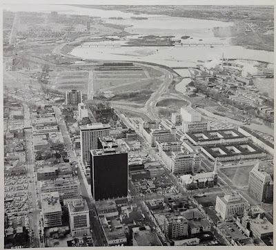
In the previous post, Part 10, we took a step back into the NCC's rearrangement of land and roads in LeBreton Flats in the 1960s. This resulted in the splitting of Wellington Street ending just west of Bay Street as it turns into the Ottawa River Parkway, and connecting to itself via offramps, as we can see here in this photo:1

Aerial view from above looking west in 1967. Centretown/Uppertown in the foreground including Place De Ville and Library and Archives Canada; LeBreton Flats in the midground; Ottawa River, Lemieux Island and Mechanicsville in the distance. Chaudière Island industry at work. West of Bay, Wellington Street becomes the Ottawa River Parkway with an offramp connection to Wellington Street through LeBreton Flats.

That arrangement would be relatively short-lived.

Thursday, December 29, 2022

Wellington Street Part 10: Nepean Bay and the Ottawa River Parkway

Part 10: Nepean Bay and the Ottawa River Parkway

   [Show/Hide Contents]

In the previous post, we talked about the peripheral effects on Wellington street from the Garden of the Provinces construction, the LeBreton Flats expropriations, and the lowering of the C.P.R. Prescott Subdivision (all NCC projects).

Today's post will look at the Ottawa River Parkway, whose history is not well documented insofar as it affects Wellington Street. We're still in the 1960s, prior to the breakup of Wellington at the viaduct covered in part 8.

To get us situated, this colour photo from the early 1960s shows Wellington Street winding up from the bottom of the photo up across the viaduct, through LeBreton Flats, and into downtown:1

Colour aerial photo of LeBreton Flats, Bayview, and Nepean Bay before removal of railroad infrastructure and before expropriation of LeBreton Flats. Wellington Street viaduct, O'Keefe brewery, railyards tracks roundhouse, Chaudière Victoria Albert islands, Ottawa River. Somerset viaduct.

Monday, January 24, 2022

Wellington Street Part 9: The NCC's distractions (early-mid 1960s)

Part 9: The NCC's distractions (early-mid 1960s)

   [Show/Hide Contents]

In the previous part of this series about the renamings, connections, and disconnections of Wellington Street, we looked at the Ottawa Journal campaign leading up to the August 1969 viaduct transplant that broke Wellington Street apart over the tracks to connect with Scott. Today we'll skip back a few years now to look at what the NCC was up to around Wellington Street in the early 1960s.

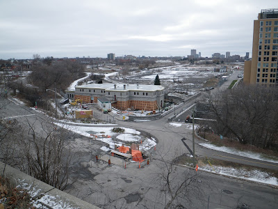
December 2012. Looking from the park atop the cliff at Bronson and Sparks down to LeBreton Flats including old Wellington Street, Pooley's Bridge, and Fleet street. Water pumping station is undergoing repairs. Condos south of Fleet not yet started construction. Transitway, no Booth Street bridge yet. A light dusting of snow.

Tuesday, August 17, 2021

Wellington Street Part 8: Viaduct traffic, Journaled

Part 8: Viaduct traffic, Journaled

   [Show/Hide Contents]

Although I set out in October 2019 to write this Wellington Street blog series looking to learn about the street's various connections and disconnections, the last three parts, ending with a look at a 1950s traffic study were a bit of a sidetrack.

The last connection change was back in Part 4 when the Wellington Street Viaduct was built in 1909 (overtop an existing route). As it happens, the next major change to Wellington Street that we'll look at is when the viaduct was replaced.

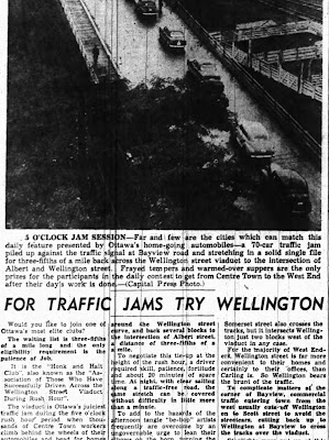
The Viaduct gets an entire post thanks to the Ottawa Journal's obsession with its role as a bottleneck for afternoon rush-hour traffic.1

1940s Newspaper article with heading For Traffic Jams Try Wellington, with a bird's eye photo of a line of cars on the Wellington St Viaduct, captioned 5 O'Clock Jam Session.

Monday, May 24, 2021

Wellington Street Part 7: Dawn of "Modern" Transportation Planning in Ottawa

Part 7: Dawn of "Modern" Transportation Planning in Ottawa

   [Show/Hide Contents]

If A.E.K. Bunnell's 1946 report covered in Part 5 recommended a few tweaks to the road network, and the 1949 Gréber report we looked at in Part 6 reimagined large swathes of the City's buildings and transportation network, a January 1955 report report on traffic and transportaion in Ottawa by consultants Wilbur Smith & Associates came in somewhere in the middle. No renamings or disconnections of Wellington Street in this installment, this time we're going on full traffic nerd mode.

This 245-page report1 took a detailed snapshot of traffic in Ottawa, and made a number of specific recommendations, many of which involved Wellington Street. In today's part of the Wellington Street blog series, we'll dive into this report and see what it had to say about traffic in general, and Wellington in particular, in the mid-1950s.

Image of the blue cover of the spiral-bound report in the Ottawa Public Library's Ottawa Room

Sunday, April 25, 2021

Wellington Street Part 6: Postwar traffic on Wellington

Part 6: Postwar traffic on Wellington

   [Show/Hide Contents]

Back in January 2020, we left off with Part 5, in which we watched traffic get heavier on Wellington Street from the 1910s to the 1940s. After a hiatus to do more research and life getting in the way, we're now back to look at government interventions in and around Wellington Street in the ten years following the end of World War II.

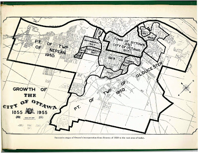
The biggest change for the City of Ottawa was on January 1, 1950,1 when Ottawa annexed nearly all nearby developed area, including Westboro, Ottawa West, Hampton Park, Highland Park, Woodroffe, Laurentian View, McKellar, Britannia, etc. Thich comprised 7,420 acres (3,000 hectares or 30 square kilometres) of Nepean and Gloucester Townships,2 as seen in the two large sections on the map below.3 Much of this was burgeoning suburban development which fed a daily stream of workers into downtown Ottawa.

Map of City of Ottawa from 1955 showing annexations/expansions up to that point, starting with Town of Bytown 1850 City of Ottawa 1855 in the middle and the largest expansions reading Pt of Twp of Nepean 1950 and Pt of Twp of Gloucester 1950.

Although Richmond Road was thus brought into the City limits, it retained its name west of Western Avenue, where Wellington ends.4 Since there were no major physical changes to Wellington Street specifically in this period, today's post will look at traffic in general on Ottawa's Wellington Street.

Wednesday, January 29, 2020

Wellington Street Part 5: Tinkering with traffic (1910s to 1940s)

   [Show/Hide Contents]


Let's continue with our journey exploring Wellington Street as the street was extended, renamed, and rerouted over its 200-year history. In today's post, we'll look at the many little clues that give us an idea of what traffic was like on Wellington Street from the 1910s to the mid 1940s.

During this time, Wellington street wasn't extended or curtailed, but traffic in the city got busier as more people drove automobiles and the City's response to this traffic problem had to mature to cope with it. To set the scene, here's LeBreton Flats from around 1930, with Wellington Street coming in from the left and winding up through to downtown:1

Black-and-white aerial photo taken from above Preston and Somerset with LeBreton Flats, Chaudière and Victoria Island, and Hull at left, and Somerset/Booth, Bronson/Laurier, and the Parliament buildings on the right. The Alexandra/Interprovincial bridge crosses the Ottawa River at the top. From the left near the bottom Wellington Street comes in and splits at Broad Street with Albert continuing straight and Wellington turning left at a shallow angle. On the north side of Wellington, west of Broad, is the Marine Signals building ('the longest in the British Empire') with trainyards and Nepean Bay beyond, and the blocks abutting Wellington on the South side are occupied by a few large industrial facilities. The other blocks further south are primarily residential.

Monday, January 13, 2020

Wellington Street Part 4: As the City grows, so does Wellington (1880-1912)

   [Show/Hide Contents]


Before our foray into the east end of Wellington Street in the previous post, we were talking in Part 2 about the first roads in Ottawa and how the fledgling town's road network began to develop in the new neighbourhood that would one day be called LeBreton Flats.

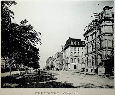
In this post we'll look at the period from about 1880 to 1912, during which time rail lines cross over Wellington at grade, fires ravage the western part of the street, Ottawa absorbs various suburbs, and an excessive number of bylaws authorize the renaming, widening, and paving of Wellington Street. To set the scene, here's what it looked like to walk in the middle of Wellington Street in 1898:1

Photo taken from Wellington Street, looking east, at around O'Connor Street, with the street extending into the horizon. From left to right: The stone and wrought iron fence at the perimeter of Parliament Hill, the north sidewalk (material unclear), a boulevard planted with a continuous row of trees, the roadway which is dirt and rutted, a bicyclist in the road heading straight toward the camera, a horse drawn carriage further away on the opposite side of the street, telephone poles each with nine rows of eight insulators, the south sidewalk (concrete?) with some trees, buildings on the south side of Wellington Street, all around 4 storeys tall. The photo has an all-caps caption at the bottom (from the book from which it was scanned), Wellington Street Looking East

Wednesday, January 8, 2020

Wellington Street Part 3: Wellington and Rideau's on again, off again, connection (1820s-1913)

   [Show/Hide Contents]


In this blog series about 200 years of physical and nominal changes to Wellington Street, most of the action is West of Bank Street, particularly in LeBreton Flats. The previous post showed the earliest of these changes. Today we will examine the changes to the east end of Wellington Street in the 1800s, as it dabbled with connections to Rideau.

This photo is of the Plaza Bridge, which spans the Rideau Canal to connect Wellington and Rideau Streets, looking east up Wellington Street with Confederation Square in the foreground and Parliament Hill on the right. It was not taken in the 1800s, but in 2012 when I visited the Chateau Laurier during Doors Open Ottawa

Monday, January 6, 2020

Wellington Street Part 2: The west end's Muddy Trails to street rails (1828-1870s)

   [Show/Hide Contents]


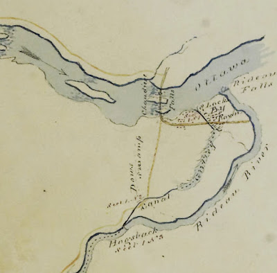
In the previous post, we drew lines from the Dukes of Richmond and Wellington and connected them to the roads bearing their names in Ottawa via the Earl of Dalhousie and Colonel By. We ended with Colonel By establishing By Town and laying down Wellington and Rideau Streets in Upper Town and Lower Town, respectively.

Today we continue the saga of Ottawa's Wellington Street and start to look at its earliest connections with other roads and the names they've had. We'll be focusing on the western end of Wellington Street as it skirts around the edge of LeBreton Flats. (The full list of posts is in the Introductory post in this series, populated as each part is posted)

Map (Sketch) of Rideau Canal drawn by Lt Col John By 1828-05-05, cropped to the intersection of Ottawa and Rideau Rivers with the nascent Bytown and initial canal locks. A yellow east-west line along the path of Rideau/Wellington Streets curves at its east end northwards and crossing the Ottawa River at the Chaudière Falls, where it intersects with Wright's Britannia Road (later Aylmer Road). At the curve, a less prominent line extends southward toward Hogsback and continues following the Rideau River. Obtained from http://passageshistoriques-heritagepassages.ca/ang-eng/recherche_et_archives-research_and_archives/militaire-military/carte-map

Thursday, January 2, 2020

Wellington Street Part 1: Ottawa's earliest roads and their namesakes (1800-1826)

   [Show/Hide Contents]

To go beyond a simplified summary and conduct a thorough review of the history of changes to all the roads in Ottawa called "Wellington Street", we need to go back to Ottawa's earliest days as a settlement and where that all came from.

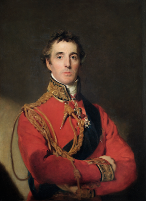
It's easy enough to say "Richmond Road was named after the Duke of Richmond and Wellington Street was named after the Duke of Wellington", but that doesn't answer the questions of who those people are and what relation they bore to Ottawa and to the people who built its first roads. So let's get into that.


Wednesday, January 1, 2020

The many traces of Wellington Street - Introduction

You may already know that Ottawa has both a Wellington Street and a Wellington Street West, but it was not always so simple. A man standing at the corner of Scott and Bayview in the pre-smartphone days of the early 2000s asked me for help finding an address on Wellington Street, and I had to confess that I didn't know which of three Wellington Streets to direct him to!


I was reminded of this recently and got curious about when these various geometric and name changes took place. I already knew that the City of Ottawa renamed many streets, including two of the Wellingtons, following amalgamation in 2001, and a quick look at an aerial photo reveals clues to how various physical changes broke Wellington Street up. Dennis Van Staalduinen tried his best to explain it on a couple of Jane's Walks in 2012 and 2013, the notes of which he has posted on his website, and a follow-up map in 2016. I even covered the topic myself in a 2010 blog post!

Photo of a green highway-style sign reading Wellington East and pointing to the right

But these were all snapshots; I wanted the whole story. I searched my own collection of books on LeBreton Flats, Ottawa, and the NCC, and found nothing describing the actual changes to Wellington Street. I searched the Web as well, but found only the most recent changes. It turns out that anybody who's written about LeBreton Flats has been more interested in the buildings, people, and land, than on the nomenclature and alignment of its primary artery! (I jest; this is entirely reasonable)

So I took a few trips to the Ottawa Room, bought a subscription to Newspapers.com, and collected a trove of information about Wellington Street, with many twists and turns along the way. Changing names and alignments is a Wellington Street tradition that goes back to the early 1800s and most recently this past September!

Over the past two months, I've painstakingly assembled this information into the following blog series to detail everything I can find out about Wellington Street—everything, that is, except for the buildings, people, and land! Depending on how you count it, Wellington Street was officially renamed between 7 and 21 times, and that doesn't even count all the times where it got physically disconnected or redirected! I've done my best to filter out the wrong information and provide sources for the rest; corrections are welcome by email, tweet, or comment (all comments are moderated).

The first part goes up tomorrow at noon, and the rest of the 10+ parts are in various stages of development and will be posted thereafter. The posts and the headings within them will be added to the bottom of this post as they are added. But first, a quick rundown of Wellington Street:

Wednesday, February 5, 2014

Peds on Weds: Part 4: A history of sidewalk design in Ottawa

Today for the fourth and final entry of the sidewalk-design series, I'm going to give a history of sidewalk design, starting at the establishment of the original City of Ottawa, in 1855 (and earlier!). In part 2 of this series, I already gave a "little history" of the Toronto-style sidewalk design, relating specifically to how they became standard back to the establishment of the current amalgamated City of Ottawa in 2001. This followed part 1, in which I described "Toronto-style" sidewalks and the problems they're meant to address, and part 3, in which I discussed some of the issues the Toronto-style sidewalk itself has faced.

Today's entry starts with the West Ward Market, built in 1848 by Nicholas Sparks. This was used as Ottawa's first City Hall, roughly where the NAC is today.

r

The first municipally-built sidewalks in Ottawa actually predate the City of Ottawa's 1855 incorporation: by-law number 37 of the Town of Bytown, approved the 23rd of September, 1850, was "To authorize the expenditure of £75 in making a Plank Sidewalk, S. side York Street":

Monday, January 13, 2014

The lonely elm

When the LeBreton Flats saw the arrival of the "road header" tunneling machine, its disembodied chewing tool seen here, an old Elm Tree played host.


The tree also played host to a stop along Dennis Van Staalduinen's Jane's Walk in May 2013, providing the walkers some shade:

Monday, January 6, 2014

The stones don't fall far from the Hill

The Confederation building (1927) and Justice building (1935) on Wellington Street just west of Parliament Hill nicely frame the original Bank of Canada building (1937) on the south side of the street when you look south from Vittoria Street.


In this space used to be a number of stone carvings from the parliament buildings, including these two top-pieces from the stonework along Wellington Street in front of Parliament Hill. The photo above and the two below were taken on Victoria Day, 2009:

Sunday, November 10, 2013

War Memorial

The war memorial at Confederation Square, at the top of Elgin Street at Wellington, is designed to be larger than life. You have to go pretty high up to get a good idea of just how big a site it is (and this photo omits the vast plaza off screen to the right). I took this photo the same day I took this one of the roof of the Central Post Office.

Obviously, this is the site of Canada's annual Remembrance Day ceremony. Every November 11 at 11am, this square is filled with veterans and dignitaries, and the streets surrounding it are packed with onlookers.


Some other things become clear at this location when viewed from above. One is that the former train tunnel that runs along the Rideau Canal below the Chateau Laurier (more recently the Canadian Museum of Contemporary Photography, and Parliamentary offices).

Another is the alignment of the Plaza Bridge. I've always been a bit confused by the layout of the concrete here (which is more slippery to bike on when it's wet), but from up above you can clearly see how it follows the Canal.

[Look for more one-photo posts under the label Singles]

Friday, September 7, 2012

Respecting veterans, heritage, and current office needs

Not too many years ago, the East Veterans Memorial Building at Wellington and Lyon (built 1949-1956) was renovated, and received some upgrades. However, I only recently noticed that these renovations included a modern office extension of the building on the top floors. On the ground, you can only see the new upper floors from the west side of the Lyon Street sidewalk, all you see from Sparks Street is the original building:

An excellent demonstration that you don't need to stick a 20-storey tower on top of a heritage building to modernize it!

There is a report on the seismic rehabilitation (PDF - Google html preview here)

[Look for more one-photo posts under the label Singles]

Wednesday, September 5, 2012

Peds on Weds: No; more ifs, ands, or buttons

Back in May I had a lengthy blog post titled No ifs, ands or buttons which described in detail how terribly complicated pedestrian buttons are in a road environment that is designed for cars.

Since that post, I noticed a few more situations I omitted about pedestrian buttons. These examples are all at the edge of Centretown or just outside it.

Outside the fancy new Ottawa Convention Centre at Colonel By Drive and Daly on the other side of the Rideau Canal, some of the concrete pavers are lined up with grooves in the middle. This is an accessibility feature so that the visually impaired can safely direct themselves to the crosswalk safely, and stop before getting to the edge. The grooves in poured concrete sidewalks perform the same function (and most streets that have precast pavers for sidewalks will use a concrete pad at the intersection to provide these accessibility features). Can you see the problem?

The groove takes you to the centre of the crosswalk, but the buttons you need to press to activate the pedestrian signal are at the edges of the crosswalk. And this crosswalk is so wide that the button on the right side didn't even fit into the shot.

But at least at that intersection, the button is necessary for anyone to use the crosswalk—not just the visually impaired—so at least there's someone else there to activate the crossing signal. As mentioned in the May entry, this is discernible by the sign above the button on the pole. If our blind pedestrian is lucky, the sighted pedestrian will press the button for three or more seconds, activating the audible signal, instead of just the quick press required to request the crossing.

Wednesday, July 11, 2012

Seeing green (#ottbike box Bay/Wellington)

Sorry for the lack of blog posts; I've been spending all my time and energy on the Bluesfest bike parking, which is Citizens for Safe Cycling's biggest fundraiser of the year. (By the way, we have not filled up yet, and the 'lineups' at the end of the night are rare, five minutes tops, so ride your bike and leave it securely with us!)

On my way back last night from the Blesfest office at 2:30am, I saw the City crews installing the thermoplastic green coating for the bike box at Bay and Wellington. This helps cyclists turn left, and avoids cyclists getting the 'right hook' from right-turning motorists. The thick plastic surface—the same stuff used in the intersections along the Laurier bike lanes—is melted on with torches and is pretty resilient. You can seee the workers melting on the final touches at the far end of the lane here, just in time for the one-year anniversary of the Laurier Segregated Bicycle Lane!

I chatted with the guy who was responsible for finalizing the design of the bike box. He also worked on the Laurier bike lanes and is working on the lane configuration for Rideau Street.

The bike box is to connect to the new segregated bicycle lane along Wellington street, which in turn connets to the pre-existing segregated bike lane on the NCC's Portage Bridge.

That whole intersection was completely redone in the last couple of months, adding crosswalks and bike lanes to the previously pedestrian-free intersection (pedestrians and bikes were expected to navigate a confusing route of paths and tunnels under the various corners of Wellington Street).

When you get to the Wellington/Portage intersection westbound, there's another new road device: since cyclists coming from Hull/Gatineau off the Portage bridge are on the wrong side of the street, they'll have to get to the south side of Wellington. This little drop-off area lets them pull away from the northbound cyclists and dismount to cross the intersection. Northbound cyclists (in the direction from which this photo was taken) can also dismount:

Dismounting is required because the Ontario Highway Traffic Act (rightly) prohibits cycling in the crosswalk. The City's cycling department wanted to install a "cross-ride" here—essentially a channel alongside the crosswalk in which you can cycle—but since the provincial law doesn't have provisions for such a facility, they couldn't. (psst: Ottawa—Centre's MPP is Yasir Naqvi, I'm sure he'll love to hear from you!)

Until it is, you'll have to get off your bike and walk. The paths and tunnels that weave under the intersection are unchanged, and still very much useable if you'd rather stay out of the intersection.

The next "missing link" in the cycling network on the City's list is the jog in the east-west Byron-Gladstone cycling route at Tyndall between Parkdale and Holland. Not in Centretown, or even in Somerset ward, but you're probably interested nonetheless.

Alright, back to Bluesfest for me! Once the festival's over, I'll have to get back through my considerable backlog in sorting my photos! Blogging will continue to be sporadic until the end of the month.