Showing posts with label Roads. Show all posts

Saturday, January 4, 2025

Wellington Street Part 12: 50 Years of Rapid Transit in Ottawa

Part 12: 50 Years of Rapid Transit in Ottawa

   [Show/Hide Contents]

I wanted to pick up the narrative of Wellington Street to line up with an important milestone in Ottawa transit history: the 50th anniversary of bus lanes in Ottawa. It doesn't involve much in the way of the theme of this blog series—the connections, disconnections, and renamings of Wellington Street—but there is a dash of that. Alas, I missed the 50th anniversary for this blog post (by over a year!) but I did get a September 2023 article on the topic published in the Centretown BUZZ newspaper.

In the previous post in the series, we left off with the 1974 opening of the Portage Bridge, connecting the west end of Wellington Street, at the Ottawa River Parkway, to Hull, and severing Wellington Street from itself in LeBreton Flats. Today, we'll rewind a couple of years to look at how rapid transit in Ottawa began to reshape traffic patterns on the various Wellington Streets, such as here on the Ottawa River Parkway:1

1974 photo of two lanes of cars curving toward the camera in a landscaped area, and two buses in the distance on a separate pair of lanes (i.e. the Ottawa River Parkway).

Friday, May 5, 2023

Wellington Street Part 11: The Portage Bridge

Part 11: Portage Bridge

   [Show/Hide Contents]

The Jane's Walks Ottawa walking tour festival takes place this weekend, with a launch event picnic dinner under the Booth Street bridge at Pimisi Station today from 6-8pm. This year's festival theme is Building Bridges, which fits in very well with the next section of my blog series on the many traces of Wellington Street: The Portage Bridge.

In the previous post, Part 10, we took a step back into the NCC's rearrangement of land and roads in LeBreton Flats in the 1960s. This resulted in the splitting of Wellington Street ending just west of Bay Street as it turns into the Ottawa River Parkway, and connecting to itself via offramps, as we can see here in this photo:1

Aerial view from above looking west in 1967. Centretown/Uppertown in the foreground including Place De Ville and Library and Archives Canada; LeBreton Flats in the midground; Ottawa River, Lemieux Island and Mechanicsville in the distance. Chaudière Island industry at work. West of Bay, Wellington Street becomes the Ottawa River Parkway with an offramp connection to Wellington Street through LeBreton Flats.

That arrangement would be relatively short-lived.

Thursday, April 27, 2023

The skinny on sidewalk design in Ottawa

Thanks to the Ottawa Lookout, I learned that today at the City's Transportation Committee meeting, Councillor Shawn Menard has a motion in relation to an ongoing review of sidewalk designs.

Since I currently have a cold, I can't present in person, so instead I wrote out a presentation to Transportation Committee. I'm reformatting it here, as a more concise rewrite of my 2014 blog series about Ramp style sidewalks (or "Toronto-style sidewalks", as they were called then).

Sidewalk with house porchsteps on the left and grassy lawn on the right, with trees providing canopy cover (west side of Queen Elizabeth Drive near McLeod Street)

Thursday, December 29, 2022

Wellington Street Part 10: Nepean Bay and the Ottawa River Parkway

Part 10: Nepean Bay and the Ottawa River Parkway

   [Show/Hide Contents]

In the previous post, we talked about the peripheral effects on Wellington street from the Garden of the Provinces construction, the LeBreton Flats expropriations, and the lowering of the C.P.R. Prescott Subdivision (all NCC projects).

Today's post will look at the Ottawa River Parkway, whose history is not well documented insofar as it affects Wellington Street. We're still in the 1960s, prior to the breakup of Wellington at the viaduct covered in part 8.

To get us situated, this colour photo from the early 1960s shows Wellington Street winding up from the bottom of the photo up across the viaduct, through LeBreton Flats, and into downtown:1

Colour aerial photo of LeBreton Flats, Bayview, and Nepean Bay before removal of railroad infrastructure and before expropriation of LeBreton Flats. Wellington Street viaduct, O'Keefe brewery, railyards tracks roundhouse, Chaudière Victoria Albert islands, Ottawa River. Somerset viaduct.

Monday, January 24, 2022

Wellington Street Part 9: The NCC's distractions (early-mid 1960s)

Part 9: The NCC's distractions (early-mid 1960s)

   [Show/Hide Contents]

In the previous part of this series about the renamings, connections, and disconnections of Wellington Street, we looked at the Ottawa Journal campaign leading up to the August 1969 viaduct transplant that broke Wellington Street apart over the tracks to connect with Scott. Today we'll skip back a few years now to look at what the NCC was up to around Wellington Street in the early 1960s.

December 2012. Looking from the park atop the cliff at Bronson and Sparks down to LeBreton Flats including old Wellington Street, Pooley's Bridge, and Fleet street. Water pumping station is undergoing repairs. Condos south of Fleet not yet started construction. Transitway, no Booth Street bridge yet. A light dusting of snow.

Tuesday, August 17, 2021

Wellington Street Part 8: Viaduct traffic, Journaled

Part 8: Viaduct traffic, Journaled

   [Show/Hide Contents]

Although I set out in October 2019 to write this Wellington Street blog series looking to learn about the street's various connections and disconnections, the last three parts, ending with a look at a 1950s traffic study were a bit of a sidetrack.

The last connection change was back in Part 4 when the Wellington Street Viaduct was built in 1909 (overtop an existing route). As it happens, the next major change to Wellington Street that we'll look at is when the viaduct was replaced.

The Viaduct gets an entire post thanks to the Ottawa Journal's obsession with its role as a bottleneck for afternoon rush-hour traffic.1

1940s Newspaper article with heading For Traffic Jams Try Wellington, with a bird's eye photo of a line of cars on the Wellington St Viaduct, captioned 5 O'Clock Jam Session.

Monday, May 24, 2021

Wellington Street Part 7: Dawn of "Modern" Transportation Planning in Ottawa

Part 7: Dawn of "Modern" Transportation Planning in Ottawa

   [Show/Hide Contents]

If A.E.K. Bunnell's 1946 report covered in Part 5 recommended a few tweaks to the road network, and the 1949 Gréber report we looked at in Part 6 reimagined large swathes of the City's buildings and transportation network, a January 1955 report report on traffic and transportaion in Ottawa by consultants Wilbur Smith & Associates came in somewhere in the middle. No renamings or disconnections of Wellington Street in this installment, this time we're going on full traffic nerd mode.

This 245-page report1 took a detailed snapshot of traffic in Ottawa, and made a number of specific recommendations, many of which involved Wellington Street. In today's part of the Wellington Street blog series, we'll dive into this report and see what it had to say about traffic in general, and Wellington in particular, in the mid-1950s.

Image of the blue cover of the spiral-bound report in the Ottawa Public Library's Ottawa Room

Sunday, April 25, 2021

Wellington Street Part 6: Postwar traffic on Wellington

Part 6: Postwar traffic on Wellington

   [Show/Hide Contents]

Back in January 2020, we left off with Part 5, in which we watched traffic get heavier on Wellington Street from the 1910s to the 1940s. After a hiatus to do more research and life getting in the way, we're now back to look at government interventions in and around Wellington Street in the ten years following the end of World War II.

The biggest change for the City of Ottawa was on January 1, 1950,1 when Ottawa annexed nearly all nearby developed area, including Westboro, Ottawa West, Hampton Park, Highland Park, Woodroffe, Laurentian View, McKellar, Britannia, etc. Thich comprised 7,420 acres (3,000 hectares or 30 square kilometres) of Nepean and Gloucester Townships,2 as seen in the two large sections on the map below.3 Much of this was burgeoning suburban development which fed a daily stream of workers into downtown Ottawa.

Map of City of Ottawa from 1955 showing annexations/expansions up to that point, starting with Town of Bytown 1850 City of Ottawa 1855 in the middle and the largest expansions reading Pt of Twp of Nepean 1950 and Pt of Twp of Gloucester 1950.

Although Richmond Road was thus brought into the City limits, it retained its name west of Western Avenue, where Wellington ends.4 Since there were no major physical changes to Wellington Street specifically in this period, today's post will look at traffic in general on Ottawa's Wellington Street.

Wednesday, January 29, 2020

Wellington Street Part 5: Tinkering with traffic (1910s to 1940s)

   [Show/Hide Contents]


Let's continue with our journey exploring Wellington Street as the street was extended, renamed, and rerouted over its 200-year history. In today's post, we'll look at the many little clues that give us an idea of what traffic was like on Wellington Street from the 1910s to the mid 1940s.

During this time, Wellington street wasn't extended or curtailed, but traffic in the city got busier as more people drove automobiles and the City's response to this traffic problem had to mature to cope with it. To set the scene, here's LeBreton Flats from around 1930, with Wellington Street coming in from the left and winding up through to downtown:1

Black-and-white aerial photo taken from above Preston and Somerset with LeBreton Flats, Chaudière and Victoria Island, and Hull at left, and Somerset/Booth, Bronson/Laurier, and the Parliament buildings on the right. The Alexandra/Interprovincial bridge crosses the Ottawa River at the top. From the left near the bottom Wellington Street comes in and splits at Broad Street with Albert continuing straight and Wellington turning left at a shallow angle. On the north side of Wellington, west of Broad, is the Marine Signals building ('the longest in the British Empire') with trainyards and Nepean Bay beyond, and the blocks abutting Wellington on the South side are occupied by a few large industrial facilities. The other blocks further south are primarily residential.

Monday, January 13, 2020

Wellington Street Part 4: As the City grows, so does Wellington (1880-1912)

   [Show/Hide Contents]


Before our foray into the east end of Wellington Street in the previous post, we were talking in Part 2 about the first roads in Ottawa and how the fledgling town's road network began to develop in the new neighbourhood that would one day be called LeBreton Flats.

In this post we'll look at the period from about 1880 to 1912, during which time rail lines cross over Wellington at grade, fires ravage the western part of the street, Ottawa absorbs various suburbs, and an excessive number of bylaws authorize the renaming, widening, and paving of Wellington Street. To set the scene, here's what it looked like to walk in the middle of Wellington Street in 1898:1

Photo taken from Wellington Street, looking east, at around O'Connor Street, with the street extending into the horizon. From left to right: The stone and wrought iron fence at the perimeter of Parliament Hill, the north sidewalk (material unclear), a boulevard planted with a continuous row of trees, the roadway which is dirt and rutted, a bicyclist in the road heading straight toward the camera, a horse drawn carriage further away on the opposite side of the street, telephone poles each with nine rows of eight insulators, the south sidewalk (concrete?) with some trees, buildings on the south side of Wellington Street, all around 4 storeys tall. The photo has an all-caps caption at the bottom (from the book from which it was scanned), Wellington Street Looking East

Wednesday, January 8, 2020

Wellington Street Part 3: Wellington and Rideau's on again, off again, connection (1820s-1913)

   [Show/Hide Contents]


In this blog series about 200 years of physical and nominal changes to Wellington Street, most of the action is West of Bank Street, particularly in LeBreton Flats. The previous post showed the earliest of these changes. Today we will examine the changes to the east end of Wellington Street in the 1800s, as it dabbled with connections to Rideau.

This photo is of the Plaza Bridge, which spans the Rideau Canal to connect Wellington and Rideau Streets, looking east up Wellington Street with Confederation Square in the foreground and Parliament Hill on the right. It was not taken in the 1800s, but in 2012 when I visited the Chateau Laurier during Doors Open Ottawa

Monday, January 6, 2020

Wellington Street Part 2: The west end's Muddy Trails to street rails (1828-1870s)

   [Show/Hide Contents]


In the previous post, we drew lines from the Dukes of Richmond and Wellington and connected them to the roads bearing their names in Ottawa via the Earl of Dalhousie and Colonel By. We ended with Colonel By establishing By Town and laying down Wellington and Rideau Streets in Upper Town and Lower Town, respectively.

Today we continue the saga of Ottawa's Wellington Street and start to look at its earliest connections with other roads and the names they've had. We'll be focusing on the western end of Wellington Street as it skirts around the edge of LeBreton Flats. (The full list of posts is in the Introductory post in this series, populated as each part is posted)

Map (Sketch) of Rideau Canal drawn by Lt Col John By 1828-05-05, cropped to the intersection of Ottawa and Rideau Rivers with the nascent Bytown and initial canal locks. A yellow east-west line along the path of Rideau/Wellington Streets curves at its east end northwards and crossing the Ottawa River at the Chaudière Falls, where it intersects with Wright's Britannia Road (later Aylmer Road). At the curve, a less prominent line extends southward toward Hogsback and continues following the Rideau River. Obtained from http://passageshistoriques-heritagepassages.ca/ang-eng/recherche_et_archives-research_and_archives/militaire-military/carte-map

Wednesday, January 1, 2020

The many traces of Wellington Street - Introduction

You may already know that Ottawa has both a Wellington Street and a Wellington Street West, but it was not always so simple. A man standing at the corner of Scott and Bayview in the pre-smartphone days of the early 2000s asked me for help finding an address on Wellington Street, and I had to confess that I didn't know which of three Wellington Streets to direct him to!


I was reminded of this recently and got curious about when these various geometric and name changes took place. I already knew that the City of Ottawa renamed many streets, including two of the Wellingtons, following amalgamation in 2001, and a quick look at an aerial photo reveals clues to how various physical changes broke Wellington Street up. Dennis Van Staalduinen tried his best to explain it on a couple of Jane's Walks in 2012 and 2013, the notes of which he has posted on his website, and a follow-up map in 2016. I even covered the topic myself in a 2010 blog post!

Photo of a green highway-style sign reading Wellington East and pointing to the right

But these were all snapshots; I wanted the whole story. I searched my own collection of books on LeBreton Flats, Ottawa, and the NCC, and found nothing describing the actual changes to Wellington Street. I searched the Web as well, but found only the most recent changes. It turns out that anybody who's written about LeBreton Flats has been more interested in the buildings, people, and land, than on the nomenclature and alignment of its primary artery! (I jest; this is entirely reasonable)

So I took a few trips to the Ottawa Room, bought a subscription to Newspapers.com, and collected a trove of information about Wellington Street, with many twists and turns along the way. Changing names and alignments is a Wellington Street tradition that goes back to the early 1800s and most recently this past September!

Over the past two months, I've painstakingly assembled this information into the following blog series to detail everything I can find out about Wellington Street—everything, that is, except for the buildings, people, and land! Depending on how you count it, Wellington Street was officially renamed between 7 and 21 times, and that doesn't even count all the times where it got physically disconnected or redirected! I've done my best to filter out the wrong information and provide sources for the rest; corrections are welcome by email, tweet, or comment (all comments are moderated).

The first part goes up tomorrow at noon, and the rest of the 10+ parts are in various stages of development and will be posted thereafter. The posts and the headings within them will be added to the bottom of this post as they are added. But first, a quick rundown of Wellington Street:

Monday, February 10, 2014

Snow removal on Bank Street (video)

On the left, the snow accumulation on Bank Street's west sidewalk from the previous snowfall. On the right, the mostly-bare road and sidewalk minutes after the City took the same snowbanks away from the east side of Bank Street last night:


I described the process in more detail in my 2012 post, "Snow removal on Kent." In summary, some very deft sidewalk plow operators push the snow from around various obstacles on the sidewalk into the road. Then graders like this one go by to arrange this snow into a straight row on the roadway:


Then, of course, the big snow blower machine comes by to whisk the snow (and ice!) all away with ease, while a lineup of trucks follow in wait of their turn to collect the snow from the blower:


I took a video of the blower going by. Watch it in stunning HD:


As described at a briefing last week at the City's Transportation Committee, snow removal (that is, physically removing it from the road and taking it someplace else, as opposed to snow clearing, which is just pushing it aside) makes up the biggest part of the City's winter maintenance budget. Of the $11.8M spent to clean up after the December 20 storm, most ($7.2M) was spent on snow removal. By contrast, $873,000 was spent on sidewalk clearing during and after that storm, which amounts to about a dollar per person for that one storm.

Wednesday, January 29, 2014

Peds on Weds: Toronto-style sidewalks part 3 - the downsides

There has been a fair amount of criticism of the Toronto-style sidewalk design since it was made the standard in the City of Ottawa in 2006, just as there have been various challenges implementing it. As with any standard, you can't please all of the people all of the time, especially in a constrained physical environment like Delaware Avenue, below:


In the first part of this series, I described what "Toronto-style" sidewalks are and how they're supposed to work. In the second part, I detailed the rather technical history of how this sidewalk design, also known as "ramp-style vehicle access crossing", became standard, following through minutes from post-amalgamation City of Ottawa through to 2006.

Feedback about the design started as soon as the sidewalks on Delaware (pictured above) and Holland Avenue were installed for the pilot project. Since then, the design has also received its share of criticism from various sources. Today I'll be discussing these criticisms, and other issues the standard has encountered. I'll finish the series next week with a review of alternatives, starting with how Ottawa's sidewalks have been designed through the ages.

Monday, January 20, 2014

Saving the day on Cooper Street

During warm/wet spells like the one we got a couple weekends ago, I bring a sidewalk scraper around with me to clear away some of the more persistent ice banks that were blocking drains around the neighbourhood. Oftentimes it only takes a minute or two to clear a small path and gravity does the rest, the water widening its channel as more of it passes through. It's important to have cleared away these puddles while it's warm so they don't turn into skating rinks on days like today, where it's minus 15 Celsius!

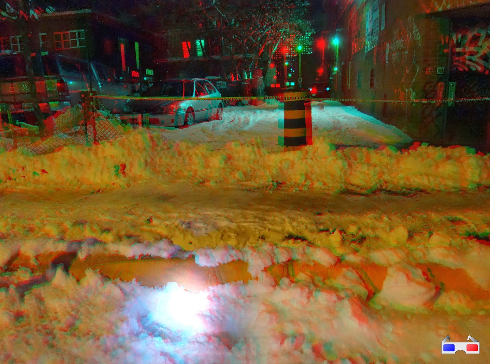
On Cooper Street at Metcalfe there was a big one, stretching across the sidewalk and most of the way across the roadway. This one would be a challenge!!


You can often find a catchbasin in the sidewalk which is blocked by some snow/ice, or at least the yellow "T" on the centreline of the road points to the nearest drain on the edge of the sidewalk. But this stretch of Cooper still has its rectangular grates in the road, and even if Cooper had the yellow Ts, the water was too deep to see them!

Normally at this point I'd just call it in to 3-1-1 and let the City crews figure it out. I did that for a couple of spots on Florence where the ice banks were required too much effort to hack a channel through, and on Christie Street where an even bigger puddle than the one on Cooper wouldn't drain at all despite reaching the drains.

In addition to heavy equipment, City crews have calcium chloride, a strong salt that they dump into the catchbasin, melting whatever snow is clogging the drain. This is the same stuff they spread on the roads, too.

But this puddle was too odd. I whipped out my phone and pulled up the location in Google Street View (a stripped-down version accessible quickly via the City's GeoOttawa map):


I had already moved down the street on my phone in search for another catchbasin when I took this photo, but alas the only one was between two driveways. You can see it below, where it came up incidentally in this November 2011 shot which I tagged in my photo collection with "vanscaping":


Being between two adjacent driveways, the sidewalk was dipped horribly down and therefore engulfed in water. It was in line with the fence that runs between the two laneways, which was a helpful landmark, but my feet would be completely underwater if I went in (I'd left my rainboots at home!).

Luckily, leaning against the fence was a bedframe that someone was throwing out. After removing the casters, I was able to use this—very carefully—as a bit of a raft to give me drier footing to just barely reach the catchbasin.


I chipped away at the submerged ice in the approximate location of the catchbasin until I heard and felt the distinct "plunk" that meant that I had reached the catchbasin! That is, I had cleared the ice off of one of the twelve little rectangles of the grate. I stepped back and tried to look for signs that the puddle was draining. Between the wind and passing cars, the floating surface ice seemed to be gyrating, but I wasn't sure if this was because it was draining, or just currents from the wind and passing cars (or, given the size of the puddle, tides!).

But sure enough, the next day on my way to work, the puddle was gone!


So the next mystery was, was it my intervention that did the trick? Well, looking at the scene, there wasn't any obvious signs of the City coming by to clear it with machinery. Presumably if a crew had come by, they would have waited until it was all drained, in which case they wouldn't have left it covered with snow and slush like it is. It's also possible that time and the warmish weather helped erode the ice blockage.

Needing to satisfy my curiosity, I sent an e-mail to 3-1-1 asking if they had received any calls from anyone else. They replied a few days later to say that, no, they hadn't received any requests for that location, so the credit for clearing the pond was all mine!

I'll share the credit with gravity, of course :)

Thursday, December 12, 2013

3D Thursday: Gladstone block

I haven't blogged much about the Gladstone Avenue reconstruction project, perhaps because as far as street reconstructions go it's fairly straightforward; only four blocks, and not a major commercial street like Bank, Somerset, or Preston. My only Gladstone reconstruction post was also a 3D Thursday post. (Incidentally, there's an open house this Wednesday for the Queen Street redesign, 11 December 2013 at 5:30-8pm, City Hall)

Due to time constraints, the contractor only undertook one block this year, between Metcalfe and Elgin. Some years the snow comes pretty late, allowing for an extended construction season. This year, unfortunately, is not one of them, and snow fell after the curbs were put in for the much-wider sidewalks:

Source photos for the 3D image: Left, Right

The next photo shows in 3D what you can't see in the 2D equivalent (linked immediately below the photo): that the curbs (under the orange tarps) are higher than the sidewalk bed behind them.

Source photos for the 3D image: Left, Right

It was a bit of a mess at the Metcalfe end of the block while all this was sorted out.

Source photos for the 3D image: Left, Right

The following week, the road and sidewalks were stripped of the snow and graded with asphalt. It was probably the least snowy street in Ottawa (even if it was also the least-paved one). This excavator has a neat side-to-side pivot on its bucket.

Source photos for the 3D image: Left, Right

The sidewalks have been paved in asphalt temporarily for the winter, using this miniature asphalt layer vehicle (like the ones used for roads, but only about six feet wide). This might be my first attempt at nighttime 3D photos with flash, and I'm glad with how it turned out.

Source photos for the 3D image: Left, Right

The remaining three blocks between Bank and Cartier will be done next year, as will the finishing work on this block. It'll be a big improvement over how it used to look: an excessively wide street with no trees, lots of potholes, and narrow sidewalks.

[Tune in on Thursdays at noon for a new 3D image. View the 3D label for other posts with 3D images. 3D FAQ]

Wednesday, October 9, 2013

Peds on Weds: Sidewalk parking fit for Queen?

Finding room for all road users in the constrained area of an existing road allowance is tough. Especially on streets in the downtown core, north of Laurier. When Light Rail is built, the station entrances will dump thousands of passengers onto Queen Street's sidewalks, where presently these cohorts are distributed among Albert and Slater. So how do you fit all those people onto Queen Street's "meets the minimum width for City standards so they're fine" sidewalks?

One of the things that struck me as a bit odd in the City's Downtown Moves planning exercise was the prospect of reorganizing the downtown core streets (Queen Street in particular) such that the lanes which are used for parking outside of rush hour become sidewalk during rush hour. Imagine the parking lanes on the reconstructed portion of Somerset, except in the same brick as the sidewalk and with no curb, or at most a token separation of an inch or so.

Aside from skepticism that this will ever happen (no source of funding was identified for implementing DOMO's recommendations, meaning that post-LRT changes to the streetscape beyond road paint and signage are unlikely), I'm also skeptical to the practicality of this particular recommendation.

Exhibit A: O'Connor Street, east side, just south of Albert, next to the Sheraton:


I'd never noticed it before because I don't go that way often, and when I do there are usually cars parked over it. But in the space (which is signed as a "Hotel zone") you have a parking lane built in concrete like a sidewalk at the roadway surface level. Right where I was standing when I took the picture is a pinch point, and if you're walking southbound (toward the camera) there is a building that blocks your view of pedestrians coming in the other direction. I'd be interested to learn from people who walk this sidewalk regularly if this is indeed the case.

It's signed as a hotel zone, so parking is allowed there during rush hour too. This means that it isn't currently used as an 'overflow sidewalk', but the designs in DOMO for the part-time sidewalks looked pretty close to this. However, the curb made for a big difference: even though the space was empty, I instinctively hugged the sidewalk and avoided the step down the curb (though I might have been pushing my bike at the time...). I can imagine the psychological barriers to such a facility being practical, not to mention the fit the traffic engineers would have to put cars and pedestrians in the same place at different times!

If you eliminate the curb, would it be better? I'm not so sure. For walking on, perhaps, but have a look at Exhibit B: I was in Brockville to check out a park named for an ancestor of mine. Brockville's main street has a cobbled parking lane between the road and the sidewalk which swoops up to meet both of them at their respective grades:


This bears some similarity to 'naked streets', which is a philosophy I agree with in theory: you get cars, bikes, and peds all in the same space and everyone slows down and pays attention to what's going on. Eric happened to mention it in his latest.

In practice, however, I found this very unsettling—both as a motorist and as a pedestrian. I'm fine with parallel parking (though many aren't), but you're also doing it on an angle, which throws off some of your reference points, and there's no bump when you hit the curb to back you up if you went too far; you hit some piece of sidewalk furniture and potentially damage both it and your vehicle. (This is actually the point of naked streets, to some extent)

But as a pedestrian, I was surprised at how unsettling it felt to walk along a sidewalk with cars manoeuvering, essentially, in 'my' space. Because the sidewalk was flush with the slopey parking lane, it felt like people were parking their cars on the sidewalk. And it was equally discomforting to know that the motorist has no curb to bump into to let them know they went too far. Not only could the motorist hit a piece of sidewalk furniture (of which Brockville's main street sidewalks were voluminously supplied), but they could hit me!

Sometimes these things just take some getting used to, like how I've learned to relax when people walk in the Laurier segregated bicycle lane (making it a de facto overflow pedestrian lane when the sidewalk is crowded). But curbs are there to keep people from driving on the sidewalk, and if you take them out to let people walk in the 'car space', then it's hard to keep the cars from driving in the 'pedestrian space'.

[Tune in on Wednesdays at noon for a new pedestrian-themed blog post. View the Pedestrians label for previous Peds on Weds posts]

Monday, September 30, 2013

Bronson reopens for the last time

After two years of construction, Bronson Avenue reopens to through traffic today, whereas it had been closed between Laurier and Somerset (the headline of the linked PSA wrongly states Gladstone). I thought I'd post some snapshots to summarize the progress.


As with last year, the reopening isn't necessarily something to celebrate, as Bronson will no doubt return to its status as a traffic sewer for hasty drivers with little or no connection to Centretown, the roadway is the same width as before the reconstruction (despite the Community's strong desire to get it rebuilt otherwise), but without all the potholes to slow them down. There will hopefully be some degree of relief on the side streets which have been host to cut-through traffic when Bronson was closed.

Recall how disruptive the closure was to road users of all modes. Not only did it disrupt the patterns of people who were just passing through, but when the intersection of Somerset and Bronson was closed, bus riders had quite a walk to get to the nearest bus stop. Customer traffic to the businesses along Bronson slowed to a trickle when Gladstone was closed. There were some attempts to maintain temporary sidewalks for pedestrians also, as seen here in the muddy mess of a street, looking north along the former east sidewalk:

Monday, September 16, 2013

Movie fans visiting World Exchange Theatre tonight

The World Exchange Centre is a shopping centre/office/parking complex that covers the entire block surrounded by Albert, Metcalfe, Queen and O'Connor streets. The complex includes two office towers (TD tower, built in 1991, and 100 Queen, built in 2001), a rooftop clock, a shopping centre (The World Exchange Plaza, also built in 1991, in which is the NCC's infocentre kiosk), a five-storey underground parking garage and a public plaza on the Metcalfe end:


The Plaza also contains Ottawa's last first-run downtown movie theatre, now that the cinemas are closed at the Rideau Centre. With Empire getting out of the cinema business, a new operator is being sought, with uncertain prospects. (More on this further down)

Tonight, people who want to see the theatre stay open are being encouraged to join a Fill The Theatre event to see the 6:30pm screening of the film "The Family" starring Robert De Niro, Tommy Lee Jones and Michelle Pfeiffer. They also have a Facebook group to promote the cause.


Anyhow, back to the building...