- 1880 Renaming of George Street, Victoria Terrace, and Richmond Road
- Railway Crossings
- Great big fires
- 1908 Renaming of Richmond Road through Hintonburg
- Wellington Street Vidauct
- Wellington widening and paving through Hintonburg
- Clearing up the 'middle section' of Wellington
- 1912 Re-renaming of George Street and Victoria Terrace
- References
Before our foray into the east end of Wellington Street in the previous post, we were talking in Part 2 about the first roads in Ottawa and how the fledgling town's road network began to develop in the new neighbourhood that would one day be called LeBreton Flats.
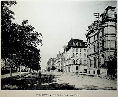
In this post we'll look at the period from about 1880 to 1912, during which time rail lines cross over Wellington at grade, fires ravage the western part of the street, Ottawa absorbs various suburbs, and an excessive number of bylaws authorize the renaming, widening, and paving of Wellington Street. To set the scene, here's what it looked like to walk in the middle of Wellington Street in 1898:1
1880 Renaming of George Street, Victoria Terrace, and Richmond Road
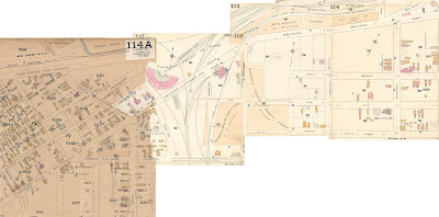
At the end of Part 2, I had included plate 43 from the 1878 Ottawa Fire Insurance Maps. Here is a broader view, in which I've combined the plates in the Uppertown-LeBreton Flats area into a mosaic.2 In it, you can see that the segments connecting Wellington with Richmond Road are no longer called "George Street" and "Victoria Terrace", but "Wellington Street":
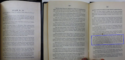
What's even more interesting (to the type of person reading a multi-part blog series about the routing and naming of a street) is that the segment wasn't formally renamed Wellington Street until two years after the insurance plans were drawn: On January 16, 1880, Ottawa City Council passed By-Law No. 475, "By-Law to change the names of certain streets in the City of Ottawa," a document that was surprisingly difficult to track down.3
The six-page By-Law renames 50 street segments and gives them 44 names, either to replace a name already used elsewhere in the city (as with George St) or to consolidate continuous road segments with multiple names (as with Wellington). The operating paragraph for our purposes, highlighted in the image above (emphasis added), is:
That the streets forming the boundary between Victoria and Wellington Wards and extending from Wellington street to Hill street, heretofore called George Street, and the street extending from Hill street to Broad street, heretofore called Victoria Terrace, and the street extending from Broad street to the City limits, heretofore called Richmond Road, be hereafter called and the same is hereby called Wellington street.The description makes reference to the boundary between Victoria Ward and Wellington Ward. However, the ward boundaries themselves are defined elsewhere in relation to the street names,4,5 making the reference to this boundary at best redundant and at worst circular!
The other part of the bylaw to nitpick is that it renames the section of Richmond Road "from Broad street to the City limits". In 1880, Richmond Road was the southerly City limit between Booth (then Division) Street and just past where the street made a southwest turn. The City Limits hadn't changed since Ottawa's incorporation in 1855, but there would be five annexations between 1887 and 1911 (three of which affect Wellington Street). I can imagine technical reasons for and against referencing "City Limits" defined elsewhere, instead of defining the actual boundaries using an objective tool such as a surveyor's description.
Railway Crossings
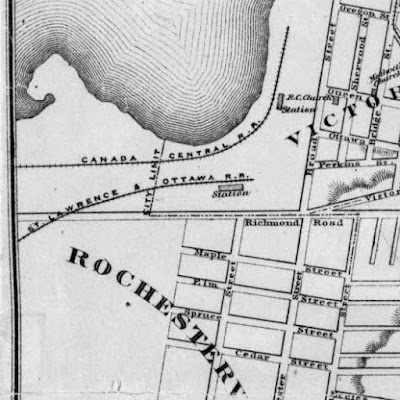
The next set of changes to Wellington Street involved the railways. As described in Part 3, the Hull-St. Patrick street rail line was the first on Wellington, opening in 1870. The following year,6 the first intercity railroad crossed Wellington Street: a spur of the St. Lawrence and Ottawa railway, previously called the Bytown and Prescott Railway and later the Canada Pacific Railway.7 The spur line crossed then-Richmond road just outside City Limits to arrive at the north side of the Broad Street station as seen on this 1874 map.8
In 1879,6 the Canada Atlantic Railway was the second to cross Richmond Road, with platforms on the south side of the Broad Street station, as seen on this 1885 fire insurance map of the Lumber District.9 The map also shows that the St. Lawrence & Ottawa line forked into two tracks just before it crossed Richmond Road: one heading east into Chaudière, the other west to the CPR's tracks over the Lemieux Island bridge (later Prince of Wales bridge).
The January 1, 1889 annexation10 of the streetcar suburbs11 of Stewarton, Rochesterville, Mount Sherwood and Orangeville12 would result in the City Limits being extended to the far side of the tracks, along the east edge of Little Chaudière (later Bayview Road, now Bayview Station Road13) and Fourth Avenue (later Bayswater14) which met at Richmond Road.
This 1887 map reproduced in The City Beyond15 shows the railroads with a bit more context, including J.R. Booth's extension of the line around the eastern perimeter of LeBreton Flats. Note that Scott Street west of the tracks is just referred to as "Road allowance between [Concession] A and First [Concession]".15,4
The 1888 fire insurance maps16 show these at-grade crossings (including a fourth across Wellington Street not reflected in maps for public consumption17,18,19) with even more detail with the more westerly City Limit. The darker paper is from the original 1888 drawing (with patches pasted in as individual lots were developed), and the lighter paper reflects areas where entire sections of map were redrawn in 1901. As we can see, there was a bit of confusion about the name of the road, possibly owing to the imprecise wording of that definition in 1880: Through the tracks (now within City Limits) it is labelled "Wellington (late) Richmond Road", but west of there in Hintonburg (which would not be annexed until 1907) it is labelled "Richmond Road or Wellington St."
Great big fires
If the area east of the railyards looks a little sparse it's because of an event that changed the entire lumber district on April 26, 1900:20
The 1900 fire devastated this area, destroying the "stylish" part of Wellington Street where "where well-to-do Ottawans built their fine homes".21 The block between Rochester and Division (later Booth) would go from having four grand residential addresses along its south side in 188816 to fifteen by 1912.22
Being a road, Wellington Street did not burn down like the buildings surrounding it, so I won't dwell on the well-covered topic of the fire. For further reading, see the Urbsite blog post about the fire from which I got the Lumber District and Conflagration map above.
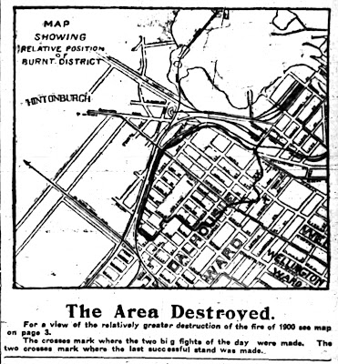
There was another major fire three years later which was more limited to Dalhousie Ward and came up to Wellington Street without crossing it. 200-250 people were displaced, but there were no injuries. The Journal reported the following day that the fire started in one of J.R. Booth's lumber yards, which lost 18 million feet of lumber, valued at over $150,000, and "is thought to be due to incendarism, and John White, a man who has recently been released from serving a ten-year sentence for firing Booth's piles some years ago, has been place under arrest." Because of the substantial attention received by the 1900 fire, City Council decided not to ask for outside assistance, and voted the morning after the fire to grant "$50 to each family, spinster or widow whose property was destroyed in yesterday's conflagration and that the amount be final so far as this council is concerned."23
The Journal23 and the Citizen24 both had graphics showing the extent of the fire (the Journal's shown here):
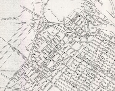
That map appears to use the same base map as this 1903 water distribution map,25 cropped to show Wellington Street, Chaudière Falls, and St. Louis Dam at Dow's Lake:
1908 Renaming of Richmond Road through Hintonburg
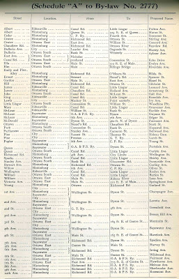
Richmond Road came into the City Limits as far west as about Irving (then Sixth Avenue) when Bayswater was annexed on July 27, 1907,26 and to Western Avenue (called Skeads Road until 193027) when Hintonburg was annexed on December 16, 1907.26 Richmond Road through Hintonburg (i.e. as far west as Western) would be renamed to Wellington Street on June 25, 1908, in a renaming that would also extend Somerset (formerly Cedar) and rename Carling, Bronson, and others listed in Bylaw No. 2777's Schedule "A".14 That schedule isn't in the bylaw books at the Ottawa Public Library's Ottawa Room; however, the fine folks at the City of Ottawa Archives forwarded me a copy:
Wellington Street Vidauct
By 1909, with the western suburbs continuing to grow, the at-grade railway crossings of Wellington were getting impractical so a viaduct was built to carry Wellington Street over them. The Ottawa Citizen describes its official opening in an article in its Christmas Eve 1909 edition:28
“The new Wellington street viaduct was formally declared open for traffic yesterday afternoon by Mayor Hopewell and City Engineer Ker and members of the city council. The first vehicles to cross after the ropes were lowered were those of a couple of farmers who were wending their way homeward.An excellent post on Dave Allston's Kitchissippi Museum blog about the eastern end of Wellington Street West describes the viaduct: "It had a total length of 1,150 feet, including 550 feet of steelwork and 600 feet of approaches. It was 38 feet wide, with 30 feet of roadway and 8 feet of sidewalks." The Ottawa Journal ran a photo on December 23, 1909, a day before it opened. The caption mentions that the approaches used fill from the excavation of the Chateau Laurier:
… Formerly at this point Wellington street was crossed by four tracks, three of the C. P. R. and one of the G. T. R., within a space of 1,000 feet. Some time ago the railway commission owing to the frequency of accidents, ordered a viaduct to be built. Work was commenced in June, the city constructing the approaches and the C. P. R., the actual steelwork. While the bridge is now ready for traffic there still remain the macadamizing of the approaches and concrete curb on top to be built.
There was no special ceremony connected with the opening, the mayor simply declaring the magnificent structure ready for traffic.”
There had been calls by the Carleton County for it to instead be built 20 feet wider to accommodate streetcars,29 but that would have increased the cost. In fact, between the time that the viaduct was approved and built, Hintonburg was annexed into the City of Ottawa. Carleton County tried to use this as an excuse to back out of its share of the costs, but the Board of Railway Commissioners apportioned them one-ninth of the cost and the Supreme Court denied an appeal.30 Construction had started on May 28 when the roadway was closed, which blocked off access to two grocers on the stretch of Wellington who sued for damages in September.31
In his blog post, Allston writes that the viaduct was motivated by the 1900 fire, which burned the Somerset Street bridge and as a result "Hintonburg was cut off from the east". I haven't been able to corroborate this with contemporary accounts. To the contrary, at a tense meeting in June, 1900, where City Council was asked to retroactively approve a fourth level crossing on Wellington Street, County Councilor D. H. McLean made a deputation to Ottawa City Council, saying "If another crossing had to be tolerated a viaduct should be built over Wellington street west. The public use of the highway was now impeded by three level crossings, and the public needed protection. He considered that as a viaduct would do away with the expense of gates and gatemen, the C.A.R. and C.P.R. would not strenuously object to it."32 A viaduct was proposed, but no mention of the fire as a related reason for building it.
Another article in February 1911 discusses plans for a joint representation to the Railway Committee of the Privy Council by representatives of the City of Ottawa, Township of Nepean, and County of Carleton, to request a viaduct be constructed. The reasons are mainly for suburbanites to avoid the hazards and delays of level crossings, and notes that many farmers go three miles out of their way to avoid crossing the tracks.33 But nothing about the fire.
Additional suburbs were annexed into the City of Ottawa in February 190934,26 bringing more traffic from these growing former suburbs, and Wellington Street was navigable through the tracks (albeit shared with railroad crossings), so I'd be interested to see more evidence about how this decision came about and whether the fire had anything to do with it. Since the viaduct was built by the CPR and not by the City, a search of the Minutes and By-Laws books only turned up an agreement to build a railing along the viaduct.35
Wellington widening and paving through Hintonburg
Between April 1910 and June 1911, Wellington Street was approved for expansion to 60 feet wide between Merton and Holland. This was done under a series of 11 by-laws reminiscent of an Abbot and Costello act. Each footnote represents a separate bylaw. In order, these bylaws:
- approved the widening36,37
- approved the related expropriations of 37 parcels38
- repealed the expropriations and then approved 37 expropriations again39,40
- repealed all of the above41
- approved the widening anew42)
- approved the 37 expropriations anew43,44,45,46
- between Broad and Queen, contract with Barber Asphalt Paving Company47)
- between (a lane between Irving and Spadina) and Pinhey, contract with Ottawa Construction Company Ltd.48
- between Rosemount and Parkdale, contract with Ottawa Construction Company Ltd.,49
- between Melrose and Rosemount,50 contract with Ottawa Construction Company Ltd.,51
And finally, various parts of the Scott Street alignment in the railyards were stopped up in April 191152 and approved for sale to the Canadian Pacific Railway (which by this point owned all adjacent lands) in July 191153 after the relevant notices were placed in the papers. This is where the new roundhouse would be built.
Clearing up the 'middle section' of Wellington
As for the Grand Trunk rail line still crossing over Wellington Street at grade just east of the Viaduct, an annotation on the Fire Insurance map in use from 1902 and revised 191254 indicates that J.R. Booth's Railway line was "to be removed". This was done by order of the Railway Commission in November 1910,55 before the Grand Trunk Railway had secured rights to operate under the Viaduct, leading to the idling of 270 workers and 150 freight cars and costing the company $3,000 a day.56
This would no doubt be related to the construction of the new Union Station on the banks of the Canal at Rideau Street rendering the Broad Street station redundant. The discontinued rail line still appears on unofficial maps, such as this 1913 one,57 into the 1940s,58 but is clearly no longer physically present.
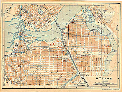
While the Citizen article correctly identifies the viaduct as being part of "Wellington Street", many non-official maps (and even the "1900 Conflagration" map above20) still call this Richmond Road. The latest one is from a pocket-sized map dating from around 1912 that I bought in 2012:59
Other maps from 1912 (below),60 1913,57 1914,61 and 192962 simply don't label this segment, but do label the segment west of it (in Hintonburg) as "Wellington Street", implying that this section goes by that name, too (and Scott Street wasn't yet connected).
1912 Re-renaming of George Street and Victoria Terrace
This could be because in on June 4, 1912, City Council officially made 29 paragraphs of street name changes in By-Law No. 3400,63 including duplicate renamings of Wellington and four others that had already been renamed in 1880:
...So, unlike in 18803 and 190864 when only portions of road were renamed Wellington, City Council made sure to declare that the entire stretch from Rideau to City Limits (there's that term again!) would be called "Wellington Street". I guess the City wasn't aware that the reason this street was "commonly known as" Wellington Street was because Council had already officially renamed it (maybe they had as much difficulty locating the 1880 street renaming bylaw as I did)!
And, whereas, certain portions of that street, in the said City, extending from the Rideau Canal to the westerly limits of the said City, which is commonly known as "Wellington Street," are described on plans in the Registry Office for the said City as "Victoria Terrace" and "George Street," and it is desirable in order to avoid confusion and inconvenience that the said Street should be known as "Wellington Street" throughout its entire length.
...
[Therefore the City approves]
4. That street, in the said City, extending from the Rideau Canal to the westerly limits of the said City, commonly known as "Wellington Street," shall hereafter be called and known as "Wellington Street" throughout its entire length and the names "Victoria Terrace" and "George Street," which are now applied to portions of the said street, are hereby changed to "Wellington Street."
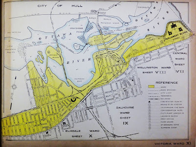
And so Wellington Street, forming Victoria Ward's southern boundary, extended from the Rideau Canal all the way through to City Limits at the far end of Hintonburg. This City of Ottawa map of Victoria Ward (from a book of ward maps in the Ottawa Room) is from 1932, but shows Wellington Street as it was by this point in the chronology.65
Wellington Street would remain mostly unchanged for the next 50 years, so next time, in Part 5*, we'll instead look at how Wellington Street fared during the rise of the era of suburbs, automobiles, and traffic. As always, I've done my best to filter out the wrong information and provide sources for the rest; corrections are welcome by email, tweet, or comment (all comments are moderated). (*When it's ready, I'll note the planned posting date in the full list of posts in the Introduction post)
Show/hide references
- 1: ▲ Carre, William H. Art Work on Ottawa, Canada, 1898, p. 2 vol 2.
- 2: ▲ Goad, Charles E. Insurance Plan of Ottawa Ontario, June 1878. Charles E. Goad, Civil Engineer [Montreal], 1878, Plates 4, 43, 46-49.
- 3: ▲▲ "By-Law No. [475]: By-Law to change the names of certain streets in the City of Ottawa." City of Ottawa Bylaws, 1879. City of Ottawa, 1880-01-16, pp. 507-512. City Council Minutes and By-Laws weren't split into separate volumes until 1890, so it is necessary to look through the minutes book for the relevant year (they also didn't have a topic index pre-1890 either). But the 1880 minutes book opens with a January 19th meeting which is composed primarily of the Mayor's speech. I eventually found the January 16 meeting minutes/bylaws at the end of the 1879 minutes book, and By-Law 475 was misnumbered in that volume as By-Law 175!
- 4: ▲▲ "18 VIC., CAP 23, An Act to erect the Town of By-town into a City under the name of the 'City of Ottawa'." City of Ottawa Bylaws, 1890 (Consolidated), 1854-12-18, pp. 356-365. Section 2 of the provincial Act establishing the City of Ottawa divides the city into five Wards: '...and the portion of the City lying westerly from the Rideau Canal shall constitute two wards, which latter two wards shall be divided by the centre of Wellington street, George street, Victoria terrace and the concession line known as the Richmond road, to the limits of the City...'.
- 5: ▲ "By-Law No. 470: To fix the places for holding the Election of Mayor and Aldermen for the City of Ottawa, for the year 1880, and to appoin tReturning Officers to hold the Nomination in each Ward, and to preside at the respective Polling Places." City of Ottawa Bylaws, 1879. City of Ottawa, 1879-12-16, pp. 373-378. This doesn't define the wards specifically, but the polling divisions within them for the 1880 year, but you get the picture.
- 6: ▲▲ Brault, Lucien. Ottawa Old & New. Ottawa Historical Information Institute, 1946, p. 192.
- 7: ▲ "Bytown and Prescott Railway." Wikipedia. Wikimedia Foundation, Accessed on 2020-01-09.
- 8: ▲ Mara & Maingy, patent agents. "Map of the City of Ottawa scale 16 chains to the inch 1874." Wikipedia. Wikimedia Foundation, Accessed on 2019-11-05.
- 9: ▲ Goad, Charles E. Lumber District Ottawa, Scale 400 Feet = 1 Inch [via Urbsite], 1885.
- 10: ▲ "51 VIC., CAP. 53: An Act to extend the limits of the City of Ottawa and to re-arrange the Wards thereof and for other purposes." City of Ottawa Bylaws, 1890 (Consolidated), 1888-03-23, pp. 366-374. This is a copy of the provincial Act reproduced in the 1890 bylaw book.
- 11: ▲ Elliott, Bruce S. The City Beyond: A History of Nepean, Birthplace of Canada's Capital 1792-1990. Corporation of the City of Nepean, 1991, p. 137.
- 12: ▲ Brault 1946 p. 28.
- 13: ▲ "City of Ottawa Street Name Changes." City of Ottawa website, Accessed on 2020-01-09, Bayview Road - From Slidell St. to Wellington St. W (addresses: 1 – 163) changed to Bayview Station Road on 2019-06-17.
- 14: ▲▲ "Schedule 'A' to By-law No. 2777." City of Ottawa Bylaws, 1908, 1908-06-25, Schedule A isn't included in the By-Law books. See a photo of it in the 'Viaduct' section of Part 4.
- 15: ▲▲ Elliott 1991 p. 123. Referencing National Archives NMC11413
- 16: ▲▲ Goad, Charles E. Insurance Plan of the City of Ottawa, Canada and adjoining Suburbs & Lumber Districts; Revised and Extended October 1898, Burnt District rearranged & revised January 1901. Charles R. Goad, Civil Engineer [Montreal], 1888, Plate 83. Plates 83 and 114 show the same location before and after the fire.
- 17: ▲ Wagner & Debes'. Map of Ottawa [ca 1894]. Wagner & Debes' Geological Establishment [Leipzig], 1894.
- 18: ▲ Map of Electroral District of Ottawa, (City,), Ont, 1895, Plate No 58. I'm not sure where this 1895 map came from; I downloaded the image in January 2014 (likely from Urbsite) but it obviously is from a book of maps, probably of Canadian electoral districts.
- 19: ▲ Reid, Basil. Twentieth Century Map of the City of Ottawa and Vicinity, Shewing Latest Surveys And Improvements. Basil Reid, 1909, A print/copy of this map was on a wall at the Ottawa Public Library's Ottawa Room. It shows streetcar routes in red.
- 20: ▲▲ Goad, Charles E. Plan showing extent of Ottawa-Hull Conflagration, Thursday, April 26th, 1900 [via Urbsite], 1900.
- 21: ▲ Bond, C.J. City on the Ottawa [Tour guide book]. Minister of Public Works. Queen’s Printer and Controller of Stationery, 1967, p. 97.
- 22: ▲ Goad, Charles E. Insurance Plan of the City of Ottawa, Ontario Volume II, December 1902. Charles E. Goad, Civil Engineer [Montreal & Toronto], 1912, Plate 114. Plate 114 shows the blocks bounded by Division (Booth), Spruce, Preston and Wellington/Albert; the composite image includes parts of plates 49, 48, 108, 111, 112, 113 and 114.
- 23: ▲▲ "West end of the city in ashes: hundreds once more homeless." Ottawa Journal, 1903-05-11, p. 1. Also from the same page: 'Council to aid sufferers; special meeting held to-day'.
- 24: ▲ "Ottawa Again Baptized With Fire." Ottawa Citizen, 1903-05-11, p. 1.
- 25: ▲ City Engineers Office Feb 1903. "Plan Shewing Water Distribution System of the City of Ottawa, Ont." Ottawa Historical Maps. Carleton University MacOdrum Library.
- 26: ▲▲▲ Elliott 1991 Annex 4.
- 27: ▲ "WESTERN AVENUE CHANGED FROM SKEAD'S ROAD / BY-LAW: 6865 (1930) FROM WELLINGTON STREET TO SCOTT STREET." An historical list of street name changes. City of Ottawa Archives, 2001, p. 128.
- 28: ▲ "Viaduct Opened." Ottawa Citizen, 1909-12-24, p. 5 Col 3.
- 29: ▲ "Wider Viaduct." Ottawa Citizen, 1907-09-26, p. 1.
- 30: ▲ "County must pay its share of Wellington St. Viaduct." Ottawa Journal, 1909-04-05, p. 1 Col 2.
- 31: ▲ "Inexcusable Delay." Ottawa Citizen, 1909-09-27, p. 1 Col 7. The grocers were at 922, 926 and 923 Wellington Street.
- 32: ▲ "Tracks Laid: Council Authorizes Another Level Crossing." Ottawa Citizen, 1900-06-14, pp. 5 Cols 4-5.
- 33: ▲ "Action May Be Taken." Ottawa Journal, 1901-02-11, pp. 4, Col 4.
- 34: ▲ Brault 1946 p. 30.
- 35: ▲ "By-Law No. 3024: A By-law to authorize the execution of an agreement with the International Marine Signal Company, Limited, for the construction of a railing on the Richmond Road Viaduct." City of Ottawa Bylaws, 1910, 1910-05-30, p. 117.
- 36: ▲ "By-Law No. 3011: A By-law to authorize the widening of Wellington Street between Merton Street and Holland Avenue, as a local improvement." City of Ottawa Bylaws, 1910, 1910-04-18, p. 82. Amended by By-Law No. 3071, Repealed by By-Law No. 3084.
- 37: ▲ "By-Law No. 3071: A By-law to amend By-law No. 3011." City of Ottawa Bylaws, 1910, 1910-08-15, p. 252. Repealed by By-Law No. 3084.
- 38: ▲ "By-Law No. 3074: A By-law to authorize the taking of certain lands for the widening of Wellington Street, between Merton Street and Holland Avenue." City of Ottawa Bylaws, 1910, 1910-08-24, pp. 258-274. Repealed by By-Law No. 3080.
- 39: ▲ "By-Law No. 3080: By-law (sic) to repeal By-Law No. 3074, intituled "A By-law to authorize the taking of certain lands for the widening of Wellington Street, between Merton Street and Holland Avenue"." City of Ottawa Bylaws, 1910, 1910-09-06, p. 286.
- 40: ▲ "By-Law No. 3081: A By-law to authorize the taking of certain lands for the widening of Wellington Street, between Merton Street and Holland Avenue." City of Ottawa Bylaws, 1910, 1910-09-06, pp. 287-303. Repealed by By-Law No. 3084.
- 41: ▲ "By-Law No. 3084: A By-law to repeal certain By-laws relating to the widening of Wellington Street, between Merton Street and Holland Avenue, as a local improvement." City of Ottawa Bylaws, 1910, 1910-10-03, p. 310.
- 42: ▲ "By-Law No. 3090: A By-law to authorize the widening of Wellington Street, between Merton Street and Holland Avenue, as a local improvement." City of Ottawa Bylaws, 1910, 1910-11-07, p. 316.
- 43: ▲ "By-Law No. 3124: A By-law to authorize the taking of certain lands for the widening of Wellington street, between Merton street and Holland avenue." City of Ottawa Bylaws, 1911, 1911-04-03, pp. 49-66. Amended by By-Laws No. 3137, No. 3152, No. 3153.
- 44: ▲ "By-Law No. 3137: A By-law to amend By-law Number 3124, entituled "A By-law to authorize the taking of certain lands for the widening of Wellington street, between Merton street and Holland avenue."." City of Ottawa Bylaws, 1911, 1911-05-15, pp. 90-92. Replaces definition of Parcel 14.
- 45: ▲ "By-law No. 3152: A By-law to amend By-law Number 3124, entituled "A By-law to authorize the taking of certain lands for the widening of Wellington street, between Merton street and Holland avenue."." City of Ottawa Bylaws, 1911, 1911-06-05, p. 141. Replaces definition of Parcel 13.
- 46: ▲ "By-law No. 3153: A By-law to amend By-law Number 3124, entituled "A By-law to authorize the taking of certain lands for the widening of Wellington street, between Merton street and Holland avenue."." City of Ottawa Bylaws, 1911, 1911-06-05, pp. 143-144. Replaces definition of Parcel 35.
- 47: ▲ "By-Law No. 3022: A By-law to authorize the execution of an agreement with the Barber Asphalt Paving Company for the paving of Wellington Street from the West limit of Broad Street to the South limit of Queen Street with Trinidad Pitch Lake Asphalt as a local improvement." City of Ottawa Bylaws, 1910, 1910-05-30, p. 115.
- 48: ▲ "By-Law No. 3085: A By-law to authorize the execution of an agreement with the Ottawa Construction Company, Limited, for paving of Wellington Street, from the west side of the lane between Irving Avenue and Spadina Avenue to east side of Pinhey Street, with Trinidad Pitch Lake Asphalt and Nepean Sand Stone Setts in track allowance as a local improvement." City of Ottawa Bylaws, 1910, 1910-10-03, p. 311.
- 49: ▲ "By-Law No. 3249: A By-law to authorize the execution of an Agreement with the Ottawa Construction Company, Limited, for the construction of an Asphalt and Nepean Sand Stone Block Pavement on Wellington street from Rosemount avenue to Parkdale avenue." City of Ottawa Bylaws, 1911, 1911-10-02, p. 479.
- 50: ▲ "By-Law No. 3251: A By-law to authorize the construction of a Trinidad Pitch Lake Asphalt and Nepean Sand Stone Block Pavement on Wellington street from Melrose avenue to Rosemount avenue as a Local Improvement." City of Ottawa Bylaws, 1911, 1911-10-02, pp. 483-484. Authorization only.
- 51: ▲ "By-Law No. 3254: A By-law to authorize the execution of an Agreement with the Ottawa Construction Company, Limited, for the construction of a Trinidad Pitch Lake Asphalt and Nepean Sand Stone Block Pavement on Wellington Street from Melrose Avenue to Rosemount Avenue." City of Ottawa Bylaws, 1911, 1911-10-02, p. 489. Approval of contract.
- 52: ▲ "By-Law No. 3121: A By-law to provide for the stopping up of a portion of the Original Allowance for Road between Concessions ''A'' and ''1'' Ottawa Front, Township of Nepean (now within the limits of the City of Ottawa) a portion of Alonzo street and Richmond street (sic) in the said City." City of Ottawa Bylaws, 1911, 1911-04-18, pp. 41-44.
- 53: ▲ "By-law No. 3180: A By-law to provide for the sale of a portion of the original road allowance between concessions ''A'' and ''1,'' Ottawa Front, Township of Nepean, (now within the limits of the City of Ottawa) and a portion of Alonzo street and Richmond street [sic], in the said City of Ottawa, to the Canadian Pacific Railway Company." City of Ottawa Bylaws, 1911, 1911-07-03, pp. 207-208.
- 54: ▲ Goad 1912 Plate 112.
- 55: ▲ "G.T.R. Ignores Board Order." Ottawa Journal, 1910-12-22, p. 2.
- 56: ▲ "Is suffering heavy loss." Ottawa Journal, 1911-01-06, p. 1 Col 2. $3,000/day is about $67,000/day in 2019 dollars.
- 57: ▲▲ Reid, Basil. City of Ottawa Canada January 1913. The Publicity and Industrial Bureau, City Hall, 1909, NMC4262. This is a photograph of a copy of the map located at the Ottawa Room, Ottawa Public Library.
- 58: ▲ V. "Ottawa [Map] Drawn Exclusively for Alert Advertising, 109 Holland Park Ave, Toronto, Ontario, 1940s." Ottawa Historical Maps. Carleton University MacOdrum Library, Accessed on 2019-11-25.
- 59: ▲ Wagner & Debes'. Map of Ottawa [ca 1912]. Wagner & Debes' Geological Establishment [Leipzig], 1912.
- 60: ▲ Cauchon & Haycock, Consulting Engineers [Ottawa]. "Map of the City of Ottawa and Vicinity, Prepared under the authority of Order in Council No. 1802 dated June 26th 1912." Ottawa Historical Maps. Carleton University MacOdrum Library, Accessed on 2019-11-25.
- 61: ▲ "Drawing No. 29: Plan of Ottawa, Hull and Vicinity 1914." Ottawa Historical Maps. Carleton University MacOdrum Library, Accessed on 2019-11-25, I believe this is from the 1915 Holt report, which explains why the map is clearly dated 1914 but Carleton has indicated 1915 in the filename.
- 62: ▲ The Mortimer Company Limited [Toronto]. "A MOTOR DRIVE through Ottawa's Parks and Driveways / Map of Ottawa and Hull also Suburbs Aylmer, Britannia, Carlinton, Deschênes, Eastview, Gatineau Point, McKellar, Rockcliffe, Westboro, Woodroffe." Ottawa Historical Maps. Carleton University MacOdrum Library, Accessed on 2019-11-25.
- 63: ▲ "By-law No. 3400: A By-law to change the names of certain streets." City of Ottawa Bylaws, 1912, 1912-06-04, pp. 273-281. The bylaw was approved by County Judge D.B. MacTavish on May 25.
- 64: ▲ "By-law No. 2777: A By-law to change the names of certain streets in the City of Ottawa." City of Ottawa Bylaws, 1908, 1908-06-25, pp. 179-181. Appendix ''A'' includes a long list of street name changes, but is not included in the 1908 bylaw book.
- 65: ▲ "Victoria Ward." City of Ottawa 1932 [Book of Ward maps]. Commissioner of Works, City of Ottawa, 1931, sheet XI.

![Section of an 1885 fire insurance map angled with extents Duke Street (North), diagonal of Wellington to Maple (Primrose)/Rochester to Spruce/Preston (East), Little Chaudiere (Bayview Station, South), and middle of Nepean Bay (West). Somerset Street between Preston and Richmond (Wellington) crosses the lower left corner of the map at a diagonal with a marker that it is a viaduct over two rail tracks coming from the south (Labelled C. P. Railway and [Canada Atla]ntic Ry.). The C.A.R. passes throu... Section of an 1885 fire insurance map angled with extents Duke Street (North), diagonal of Wellington to Maple (Primrose)/Rochester to Spruce/Preston (East), Little Chaudiere (Bayview Station, South), and middle of Nepean Bay (West). Somerset Street between Preston and Richmond (Wellington) crosses the lower left corner of the map at a diagonal with a marker that it is a viaduct over two rail tracks coming from the south (Labelled C. P. Railway and [Canada Atla]ntic Ry.). The C.A.R. passes through the J.R. Booth/Sparks Estate Yard in an area outside City Limits labelled BAYSWATER, then turns northeast and crosses Wellington just west of where Wellington makes a sharp 30 degree southwest turn at the City Limit. After crossing Wellington, the C.A.R. goes east around a building labelled 'Canada' before ending at the 'Atlantic Yard' in LeBreton Flats parallel and adjacent to Wellington Street just west of Broad Street. The C.P.R. splits just south of the diagonal section of Richmond Road, one part of which goes east into LeBreton Flats, parallel to and just north of the C.A.R. yard at Broad; the other part goes west to the Prince of Wales Bridge (not drawnn), and a switchback connects to the C.P.R. yards in LeBreton Flats parallel to Broad Street at Oregon, which splits into four tracks after crossing the Aqueduct. Two more switchbacks, both crossing the line that went to the bridge, go to the Engine House and to Pembroke on the right of way parallel to Scott Street (now the LRT Confederation Line alignment).](https://blogger.googleusercontent.com/img/b/R29vZ2xl/AVvXsEihyphenhyphendDkBcYknxK7z7uXQrDaj855G2L0_GGIIwHoc5uYBVzBdDRK_c7QnNs_0ETPsgueqnMgE2DvllOqFfP_j19TrZ05UclcZCdpMxveI683jeOJ8CK8HZTEyX2kQOREGN1CjA-oIyFSjx0/s400/fireinsur-1885-lumberdist-lebreton-flats-map-crop.jpg)






No comments:
Post a Comment