Showing posts with label Catherine. Show all posts

Wednesday, October 3, 2012

Peds on Weds: Why don't you have a seat?

This is under the entrance canopy of the Canadian Real Estate Association's national headquarters at 200 Catherine (to help locate it, you can see the nearby intersection of Bank and Catherine reflected in the building's mirror finish). The lot has plenty of landscaping at the fringes (like at Bank Street between Catherine and the 417), but the building itself is surrounded by parking and hard surfaces. This concrete planter box was installed at the entrance, perhaps to break up all the concrete, brick and glass.


But the flower planter seems to provide too much excitement, necessitating this hand-made sign shooing away people who might sit on it. The people who want to sit on the flower box are likely not doing so to spite the flowers, but because they want a place to sit. As the population ages, it's important to provide frequent seating opportunities around town to allow seniors to remain active but give them a place to rest (I know of many older adults who will walk to Hartman's and rest on the bench before going in to shop).

Considering that this is the only building on the block bounded by O'Connor, Catherine, Bank and the 417, my suspicion is that anybody who might want to sit there either works in the building or is visiting it (perhaps on a smoke break or waiting for a ride).

So why don't they just add a bench?

[Tune in on Wednesdays at noon for a new pedestrian-themed blog post. View the Pedestrians label for previous Peds on Weds posts]

[Look for more one-photo posts under the label Singles]

Monday, September 24, 2012

Lights out for the night

I recently passed by the station at night (around 10:30 p.m.) and was struck by the unusual absence of its usual blinding lights.


Once when arriving back in Ottawa on an evening flight, I noticed how brightly lit gas stations are. Looking down from over the city, gas stations stick out like sore thumbs, especially in the suburbs where gas stations are big and the streets are fairly dark.

I've since noticed it back on the ground also: every square inch of asphalt on a gas station's property is inundated with light. Normally, the MacEwen Ethanol gas station at Bank and Catherine is no exception—you risk a tan just driving by at night—but on this particular evening, it was refreshing to see them sparing the electricity.

[Look for more one-photo posts under the label Singles]

Monday, September 17, 2012

Beaver Barracks housewarming this Saturday

The CCOC is hosting a party this weekend to celebrate the housewarming of the 254 units in the five buildings that make up the Beaver Barracks project, next door to the YMCA. The second phase of the project is finished and people are moving in:

These two buildings are 100and 200 Victory Gardens Private, which are surrounded on three sides by the development's larger buildings along Argyle, Metcalfe and Catherine.

The party will be this Saturday, September 22 (which is also International Car Free Day*). Here are the details from the invitation e-mail (and yes, you are invited!):
One giant CCOC housewarming

Tenants, friends and neighbours are invited to join us in celebrating the completion of construction at Beaver Barracks and in welcoming 254 new households to Centretown.

Date: Saturday, September 22, 2012

Program: 1:00 pm - Welcome
1:15 - 1:45 pm - speeches
1:45 - 3:00 pm - tours, games

Place: 464 Metcalfe Street courtyard

­­­­­­­­­­­­­­­­­­­­­———

Nos locataires, amis et voisins sont invités à se joindre à nous pour célébrer la fin de la construction de Beaver Barracks et pour accueillir les 254 nouveaux ménages au centreville.

Date: le samedi 22 septembre 2012

Programme: 13 h - Bienvenue
13 h 15 à 13 h 45 - discours
13 h 45 à 15 h - visites, jeux

Place: Cour de 464 rue Metcalfe
I've got a big stockpile of photos and information related to this project that I'd like to eventually write up, but there's only so much time. You'll have to settle for searching my blog for posts with the Beaver Barracks label.

The CCOC has a dedicated Beaver Barracks website has many photos of the construction, designs, and other information about the development.

*Aside: Ottawa's Car Free Day celebrations used to be much more prominent, but has petered out from road closure, to partial road closure, to info fair outside City Hall, to essentially nothing. The City of Ottawa's contribution this year is little more than a media event to visit a business owner who rides a bicycle. The University of Ottawa has had Car Free Day celebrations for many years (including the 2007 edition which I recently posted about), and they have led to permanent changes that turn car space over to people space.

[Look for more one-photo posts under the label Singles]

Monday, September 12, 2011

Centretown Events and Updates for September 2011

The following message was sent to the CCCA's e-mail announcement list early this morning, announcing upcoming events. Contact ccca@centretowncitizens.ca to be among the first to receive CCCA e-mail updates a couple times per month.


Dear CCCA members and followers,

I hope you did a lot of resting up over the summer, because September is starting up at full speed!

Here's a summary of 25 upcoming events and issues in Centretown:

Friday, September 3, 2010

Bowling on Wellington

This is in Hintonburg, on Wellington Street West, but noteworthy nonetheless. On a June trip on the newly re-opened Wellington Street West, I noticed that the "G" on this sign has finally been replaced.

For quite a long time, West Park Bowling's large white-on-black letters spelled out only "B-O-W-L-I-N"--here's proof, from last August (this cropped image is the best photo of it I could find in my collection):

I believe this is the nearest place to Centretown to go bowling since the Kent Bowling Lanes on Catherine closed down and got converted to mini-storage. I remember they used to have disco bowling:

[Hm... I was going to give this post the label Singles, but there are two photos too many!]

Saturday, May 22, 2010

Museum of Nature reopens after three years of renovations

The Centretown News reports that the Museum of Nature is reopening this spring in the Victoria Memorial Museum building after three years of renovations. According to the report, it will reopen as two museums--the Museum of Man and the Museum of Natural Sciences.

"Gone are the days of the monumental exhibits that last for fifty years and look like it, [Mr. Bill Baldwin, assistant director of the museum] states emphatically."

Okay, that article is from 1972. (Click on it to view it in full size) There are a few obvious errors (it housed Parliament for a lot longer than one month), but there are nevertheless a few nuggets, like the Baldwin quote.

Regrettably, I didn't start taking photos of the museum renovations until April 2008, when they installed the columns for the lantern, and I didn't try to get access to the inside during construction. But here are a hanful of my photos from the renovations.

This shot from Metcalfe and Catherine shows the South side of the museum last June, when the Beaver Barracks building (site at left) was still in the early stages of construction:

This photo from last March shows the lantern more or less installed, with the leaded glass window still inside.

The original 1916 tower, which had been removed in 1919 becuase it was sinking in the leda clay, had an archway here. When the tower was removed, they had to fill in the archway with a window to protect it from the elements. With the current renovations and a new glass tower added, the windows can be removed and the archway restored to its original function.

Earlier this week, some finishing touches were added to the front entrance.

There is a parade today (should be on now) as part of the weekend celebration events.

Admission is free today as part of the reopening ceremonies, but that will mean it will be very busy so you should wait for another day. (Just kidding, I just want some space for when I visit today!)

The Ottawa Citizen has a lot of photos, articles, and historical views of the Museum of Nature on its special section at ottawacitizen.com/museum

Sunday, April 25, 2010

Freeway Moon

Taken Friday in Centretown. Can you guess where? (See the tags for a hint)

While the MTO's Queensway-widening project won't add any lanes in Centretown, they will do "offramp modifications" to "improve" the flow of traffic at offramps.

By "improve," they of course mean "increase": by as many as 600 more cars every day. Where will they go?

The plans also include demolishing the former OBE building on Bronson just South of the Queensway, and running the offramp through it to avoid those pesky jogs onto Isabella. The rest of the site will be turned to greenspace.

Series on T&L building construction coming soon...

[Look for more one-photo posts under the label Singles]

Saturday, February 20, 2010

Beaver Barracks fire

Long before it was reported in the Citizen, I got a phone call on Wednesday night alerting me to a fire at the Beaver Barracks housing development under construction.

I was just getting off the canal around Fifth Avenue, and managed to take a photo of some white puffs of smoke coming from the site. Major fires usually have large columns of black smoke.

Here's last photo I had taken of this building on the development, from late November:


The roads were closed at Catherine and Metcalfe:

By the time I got to the site, the fire was already extinguished, and firefighters were in the lengthy process of making sure the fire hadn't spread anywhere else.

While we've had a lot of fires lately, it was pretty clear that this one didn't do a whole lot of damage to the building. The word I've heard is that the fire was mainly on one of the scaffolding platforms, so the flames would have looked more severe to onlookers than if the fire were within the building.

I have a number of photos on the ongoing construction of the Beaver Barracks site, but I haven't spent much attention posting them because the CCOC has a good site, including photos of the progress and renderings, at beaverbarracks.ca

Sunday, November 8, 2009

Bank Street Phase III, Intro and part 1

Last year, I posted a single post on Phase II of the Bank Street reconstruction project, between Laurier West and Somerset West. This year, there's much more to post about: The new bike racks are up, and there are so many more blocks of construction to blog. I already blogged about the streetcar rail ties dug up from under Bank Street back in May.

While paring down last year's set was hard, I took many more photos of this year's work. In September, I selected the best photos, printed out thumbnails, and sorted them into groups over a cup of Earl Grey at Bridgehead:

Then I got busy, and by the time things had died down, I had taken many more photos that I wanted to incorporate into the series.

I've finally gotten around to sorting them out for posting. Click below to go to the relevant post:

Part 1: Sidewalks

Old sidewalks meet new on Bank near Catherine Street in this photo from last week. In the background is the Bank street Queensway underpass:

Here's a reminder of what the sidewalks looked like on Bank before the recent reconstruction. This shot looking South from Bank and Gloucester in front of the Tim Horton's shows a rather rather cluttered, claustrophobic, uncoordinated corner--and that's after they moved the newspaper boxes away shortly before this photos was taken in October 2007. Many intersections had an engraved stone block with the name of the intersecting street laid into the pavement. The one at this intersection had long been removed and filled in with asphalt. Another at Gladstone (photographed in this post) had been broken up through wear and tear.

Construction on Phase three of the five-phase Bank Street Reconstruction project began a year ago this week, with the removal of the sidewalk at the plagued South-East corner of Somerset and Bank.

Most of the other sidewalks down to Catherine survived until the majority of the utility work under the roads was complete. These squares of sidewalk in front of the James Street Pub were being delicately removed in late May.

Once the old sidewalks were removed and a bed of foundation gravel was laid at the right height, the new sidewalk was outlined with a guide rope suspended from a series of posts. In this mid-August photo at Bank and Gilmour, the bulbout outline is clearly visible, and guarded by yellow caution tape. The spool for the rope is visible in the foreground.

The wire is used to line up the wooden concrete forms, as shown here on Bank and MacLaren in front of the Quizno's restaurant. A gas-operated tamping machine is used to compress the gravel underneath to avoid damage to the sidewalk caused by settling.

On long, straight sections of sidewalk, they don't use wooden forms, but instead a curb-laying machine such as this one in front of the Rogers Plus store on Bank and Gilmour. It's faster, smoother, and more consistent. Eric Darwin has photos of one of these machines in use on Preston Street over at West Side Action.

Here's a closeup of the working end of the machine:

Here's the old sidewalk in front of Hartman's, looking South from Bank and Somerset. This was always a narrow block to walk down, especially where the Bank Street BIA's big black advertising box occupies a good portion of sidewalk real estate. (The old round Bank Street Promenade sign is also visible on the post in the foreground, and others are visible in the background in various rotations) This photo was taken in early December 2008.

During construction, the sidewalk had been removed. By mid-August, you can see some wooden stakes beginning to mark the new sidewalk outline on the other side of the Modu-Loc construction fence.

At the end of August, the curb was poured, and another tamping machine sits in this nighttime photo waiting to compress the gravel under the sidewalk to be poured.

Two days later, forms have been installed for the sidewalk, and a moving assembly line of Local 527 workers pour, level, and smoothen the sidewalk. The worker in the blue helmet is holding a paintbrush, which he's using to add a border around the street lamp.

And here's the finished sidewalk. The traveled portion of the new sidewalk is as wide as the entire old sidewalk, and there's an extra section for furniture to be installed. On the North half of the block, it's even wider. A new bus shelter was installed in the wider part of the sidewalk in the last couple days, which will be welcome to the many, many people who wait at that stop. Grooves increase traction at the intersection, and double as a guide for the visually-impaired.

I think the construction process was refined over last year (Bank will reopen two weeks ahead of schedule). For example, the section pictured in the photo below shows some squares of sidewalk yet to be poured in the Phase II part of the project between Laurier and Somerset. There's an earlier photo of that block in the aforementioned post from last year, showing just how many people walk through this block looking North from Gloucester:

These squares of sidewalk hold the foundations for the street lamps, and are reinforced with steel rebar. The sidewalk in front of Hartman's doesn't have rebar, and the squares with the lamps are poured at the same time as the rest of the sidewalk.

But the really peculiar thing with this stretch is that temporary wooden pole in the middle of the street!

Here's another peculiarity I spotted yesterday: six sewer grates are built into the sidewalk across from Lewis street. Six. One presumes a lot of water collects at this corner during storms. This in-curb design is great (pun unintended) for cyclists, because you don't have to swerve around them into traffic. Since they aren't in the asphalt portion of the street, cars don't run over them and break apart the surrounding asphalt, meaning they don't require repair nearly as often, meaning less patchwork of asphalt to be broken up. Sewer grates on the roadway make for vicious cycling.

All in all, the new sidewalks are much wider, fresher and cleaner than the old ones. Here's another old-and-new shot of the sidewalk in front of Herb & Spice at Bank and Lewis, December 2008:
And September 2009. Finally there will be room for adequate bike parking!

The Google Street View car went down Bank street in March, before most of the work was started. Pop a step or two down the cross-streets for a later view. While you're waiting two days for the next post, why don't you take a few minutes to check out what Bank Street used to look like on Google Street View, then take a stroll down Bank Street and notice the difference.

Tune in Tuesday for the Part II: Lights

Monday, August 25, 2008

The Iniksuit say: fix us!

On Bay Street just North of Catherine Street, there is a series of bollards keeping traffic from cutting through the neighbourhood. In the centre of the strip, there are pavers, and the outermost gaps are paved with concrete. (Unfortunately, the concrete hasn't settled as fast as the neighbouring asphalt, creating a big bump that, when I once rode it too fast, caused some usually-secure stuff to fall off my bike)

In late July, riding back from the Lansdowne Farmer's Market, I noticed the pavers were all displaced, some of them strewn about on the section where bikes are supposed to travel.

loose brick pavers in Fused Grid traffic protection on Bay Street, Ottawa
I tossed the ones blocking the cycle path into the centre area and took a photo with the intent of blogging it (uh... it took me a while).

Two new denizens of the site gave me a cute little reminder that I had not yet blogged it:


The two Inuksuit (plural of Inuksut) seem to say "hey! Look at us! Fix us!"

Let's hope they are laid to a proper and useful rest.

(As a completely geeky aside, these photos were number 4295 and 4529 on my camera, which is a neat coincidence.)

Friday, August 22, 2008

A Tempest in a Paramedic Po(s)t: a detailed historical analysis

The media are doing it again. They're falling for (and contributing to) neoconservative flamebait by sensationalizing a non-story that accuses City Council of wasting money it didn't spend. I hate it when they do that, because it inevitably results in me spending five hours into the night carefully deconstructing and documenting their errors.

It has to do with the paramedic post on the former Beaver Barracks site at 424 Metcalfe (intersection of Catherine), and accusations of "poor planning" relating to it.

The culprits:
- The Ottawa Sun (article in question) (link may not work after a while)
- CBC Online (article in question)
- The Canadian Taxpayer Federation (representatives of which are quoted in above articles)

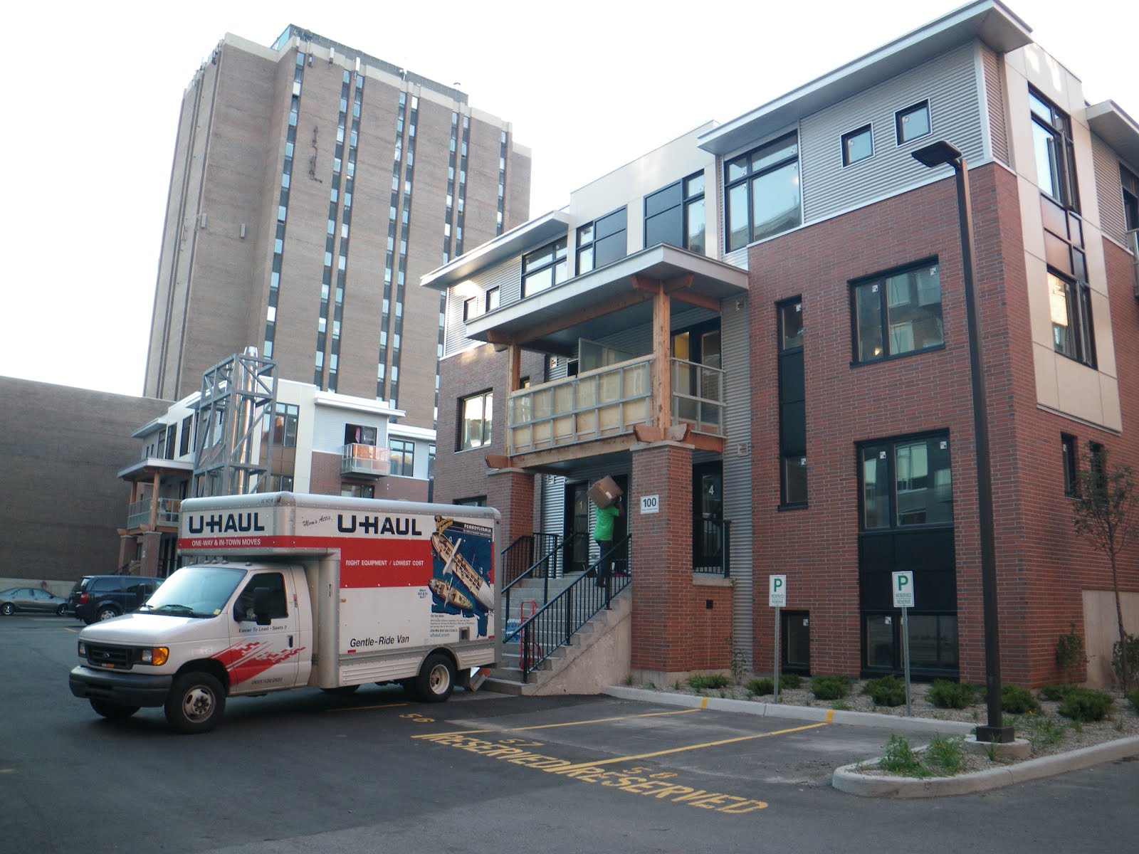
Here's a photo of the site in question:


Ottawa Sun Cover 2008-08-21 - 'POOR PLANNING' COSTS CITY. Copyright 2008 Sun Media Group - FAIR USE - COMMENTARYSo what's the issue? Well, a Paramedic Post built by the City of Ottawa for $600,000 in 2004 is being demolished and rebuilt on a different part of the same site. From this brief description, which is the same simplistic angle taken by the Sun (see yesterday's cover, inset) and CBC Online (the headline was "New $600K Ottawa ambulance station to be torn down, rebuilt"), you'd think that the City had just spent $600,000 with nothing to gain. And the taxpayer zealots are firing all guns.

Adam Taylor, research director for the Canadian Taxpayers Federation, says this is "poor planning at best and it's incompetence at worst." (CBC article)

Kevin Gaudet, the Ontario director for the CTF, cites his flawed dogma in the Sun article: 'To have a new building that has to be torn down to accommodate a newer building, at the initial expense of the taxpayer, is an absurd waste of money, Gaudet says.' (my emphasis; note, this is a quote from the article paraphrasing Gaudet, not a direct quote)

Some commenters on the CBC article take the bait and blame the city for gross incompetence, including Gary68, who "seriously demand[s]" that Councillor Diane Holmes resign.

Anyway, they're all completely wrong, many times over.


Now, I'm not an apologist for City Council (nor am I necessarily an opponent), but in the wake this bombardment of illogic I must come to the defense of Council and Councillor Holmes. You see, I did something most people didn't think to do: I actually looked at the evidence.

Let's start by explaining the current situation. The City of Ottawa owns some property (called the "Beaver Barracks site", named after the temporary buildings built during WWII for the Department of Defense) which is designated to be used for affordable housing. The site has also hosted community gardens since 1997. In 2004, the City of Ottawa constructed a building on the site for paramedics to rest while waiting for calls. This particular location is useful because the proximity to the Queensway and to Centretown arteries allows ambulances to serve Centretown well.

A new affordable housing development on the site will require this Paramedic Post to be relocated within the site (the new one will be completed before the old one is demolished).


Despite the initial cost of the Paramedic Post, both the Sun and the CBC report that this relocation will cost only $100,000, and that the cost will be borne by the CCOC. But these details are buried within both stories; the Sun and the CBC both chose to inflate the issue by parading the $600,000 figure, allowing the taxpayer "defenders" to stick to their dogma.

Gaudet claims that no matter the cost to relocate, $600,000 was misspent because that was the initial cost spent by the City, and that claim is absurd. If I were evicted from my apartment and had to move to a comparable apartment with equal rent, I would be out the money it costs to transport my furniture to a new house--not the price of my furniture!

When Taylor was told that the cost to replace the building was only $100,000, he still insists it's money wasted by the government, since the CCOC project is funded by the government.

Now let's start to deconstruct this.


First, was it a poor financial decision?

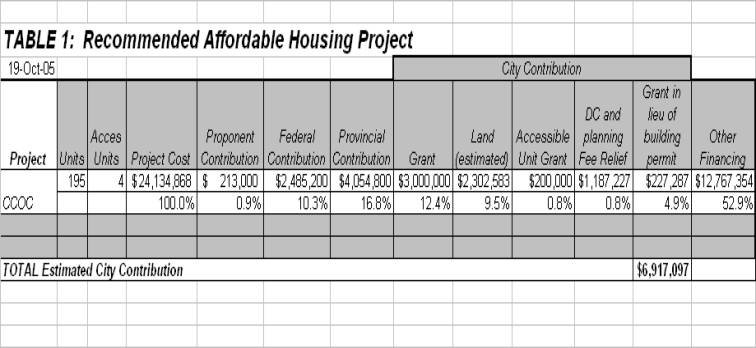
In mid 2007, the City issued an RFP (Request-for-Proposal) for social housing to be developed on the site. The Centretown Citizens Ottawa Corporation (CCOC), which is a non-profit organization specializing in providing affordable housing in central Ottawa, won the competition by a large margin at committee (Council approval here), with a $24.1 million proposal, 55% of which would be funded by governments (approx. $2.5M Federal, $4M Provincial, and $6.9M Municipal).

This means that of the $100,000 expense, only $55,000 is borne by governments at all levels.

When the Paramedic Post was approved, the City did not have any firm plans for the site (as I demonstrate in the last section below). In order to prevent conficts with a future development, the City would have had to wait until plans are drawn and executed, or build the paramedic post on another site.

To find another site would have required the city to purchase land from a private landholder, and land in Centretown would have certainly cost more than $55,000.

If they had waited, they would also have lost out. Inflation on the $600,000 investment between 2004 and 2008 would be $61,000, according to the Bank of Canada's Inflation Calculator (Yes, that uses the Consumer Price Index, which does not necessarily reflect construction costs, which I believe have risen faster than inflation).

Even if it didn't cost more, waiting would have been hazardous as well. Remember, it's not just about construction and spending, a Paramedic Post is about the safety of Citizens of Ottawa. The purpose of this Paramedic Post is to provide paramedics a place to park their ambulances so that they can swiftly respond to calls. Ambulance response times have been below targets in Ottawa for many years, and downtown was identified as needing more attention.

Now, take any of the figures, $100,000, $55,000, or $600,000 and divide by four years of operation (five, when you consider the CCOC-built Paramedic Post will not be ready until 2009), and it is much less than the cost of operating an ambulance with two paramedics (and that's only counting one shift!). Had we not built the building, how many more ambulance teams would we have had to sit on duty?

When the post was built in 2004 (or more specifically, when it was approved in 2003), there were no specific plans for the site. I dare anybody to look at interminably-undeveloped Albert Street and Transitway in the escarpment, or the lack of proper transit downtown, and try to claim that we should have waited for the City to implement plans before making this investment in safety.

It is not a waste to spend taxpayer money; only if it is spent poorly. Paradoxically, Council's poor record in planning suggest that it was actually a good planning decision for this project to go ahead as soon as was possible.


When did they make the decision to build it?


Logic and analysis aside, people are still calling for the heads of Diane Holmes and of Council. So let's take a look back in time and see where this all came from. The online minutes of Council and Committees are a good help. (as an aside, I think the Mayor's desire to spend $150,000 to go paperless is a much bigger waste of taxpayer money; the current online minutes seem to work well enough for this research...)

According to the Beaver Barracks development website, the RCAF Beaver Barracks were built on the site in the 1940s, with residences along Catherine, the Ottawa Auditorium along O'Connor, and a mess hall along Argyle. The site has a drawing from 1956 showing the site layout.

The site goes on to say that the auditorium was demolished to make way for the Metro Central Y in 1967, and the barracks themselves were taken down in 1991 leaving a field. It is now listed as a Brownfields site, according to this document from the province (translated in to html by Google). --Incidentally, the City is contributing $300,000 to clean up the toxic waste in the brownfields site, but I don't hear the Taxpayer's Federation whinging about that.--

At some point during this period, according to Councillor Cullen's recollection in a 2003 meeting, this site had been transferred to the City of Ottawa in a land swap between the Regional Municipality of Ottawa-Carleton (RMOC, precursor to the City of Ottawa), the Department of National Defense and the National Capital Commission.

Fast forward to September 2003. The City of Ottawa has identified the need to build 12 Paramedic Posts in high-density areas (reduced from an earlier estimate of 21 posts). Funds were already set aside to build them, they just needed to find places that were appropriately zoned. The Planning and Development Committee was urged by Staff to rezone this site to include such a Post in the permitted uses. Quoting from the Planning and Development Committee report's summary of the presentation by Anthony Di Monte, Director of the City's Emergency Medical Services department:

"In the Centretown area, 28% of the life-threatening calls emanate from this
high-density area, representing some 10,000 emergencies. It is an
essential public and health safety issue that needs to be
addressed.
... This area lacks the capacity to respond to an
extremely high level call volume. Having said that, funds were set aside
to build posts
where deemed necessary and through the planning process this area
was identified. It is City land and ideal because of the call
volume.
" (my emphasis)

--Let me pause the history lesson here for a moment to point out that at the time of this meeting in 2003, Diane Holmes was not a City Councillor, and nor were half of the 24 people on Council today in 2008. So Gary68's implication that Holmes is responsible for this alleged boondoggle is grossly misplaced, and arguably defamatory.--

The idea for using the site for affordable housing dates as far back as 1999, when the RMOC voted against having the site "be the subject of further planning studies and that a portion of the site be considered for affordable housing in the future." (PDF reference, or translated to HTML by Google). It's unclear whether it was already set aside for affordable housing by that point and the motion was to consider developing it, but by the 2003 PDC meeting, it was clear that affordable housing was to be one of the main purposes for this site.

Interestingly, affordable housing was not the sticking point in the debate on the Paramedic Post. Instead, it was concern that the Paramedic Post would push out the community gardens maintained on a portion of the site by the Bytowne Urban Garden Society (BUGS) since 1997.

An avalanche of community support called on the committee to make development of a Paramedic Post and affordable housing contingent on the existence of the garden. This contingency, staff said this does not represent "good planning". But this is not a foreboding of the "bad planning" accusations referred to in 2008--staff were still supportive of the ambulance post.

Councillor Cullen was very persistent in expressing his concern that the ambulance post would reduce the potential for affordable housing spaces, but it appears staff never answered his question of how many spaces could be gained by not locating the ambulance post there. This, of course, still begs the question of how much it would cost to locate it elsewere and whether that gain would have been worth it. In retrospect, we now know that the Post is incorporated as the ground level of a mixed-used building, so in an alternate reality, the CCOC might just as well have made the space into a convenience store and no additional housing units would have been gained.

Russell Mawby of the Housing Branch replied at the time that "EMS does not
significantly impact the housing development potential on the site" and "Housing is proceeding on the premise there will be an EMS facility on the site." Grant Lindsay, the City Manager answerable for the agenda item, said "the site could possibly accommodate all three uses quite comfortably."

The rezoning carried at Council, with Dwight Eastman (West Carleton) dissenting on the recommendation to include the community gardens.

As for the actual construction of the ambulance site, I can't find any reference for when it was built, or--more importantly--when it was approved. The closest is a few thousand dollars in approvals for Architectural ($51,000) and Environmental Consulting Services ($15,000)--ironically, one is listed for this "Ambulance Post" and the other for an unspecified "Proposed Paramedic Post" (the latter of which may not be the one in question). This lack of documentation implies the approval to build the paramedic post was buried in an annual budget, probably under project funding for EMS. So the decision was not exactly a prominent one, and the nuance of the now-acknowledged financial implications were far from apparent--even the CTF didn't catch it at the time!


Building the affordable housing

Finally, in August of 2004, the City issued an RFP for 220 units of affordable housing, 140 of which to be situated at the Beaver Barracks site. $7.3 million in funding was allocated to support this site.

This is probably after the paramedic post was built, likely after it was designed, and almost certainly after it was approved. Since my main point is to disprove the claim that it was a boondoggle, this timing confirms there were no plans for the housing when the paramedic post was built.

To further support this, in June 2006 on an unrelated issue at the Beaver Barracks site, it was reported that "A design plan is expected in 2006, and site development could begin as early as the summer of 2007."

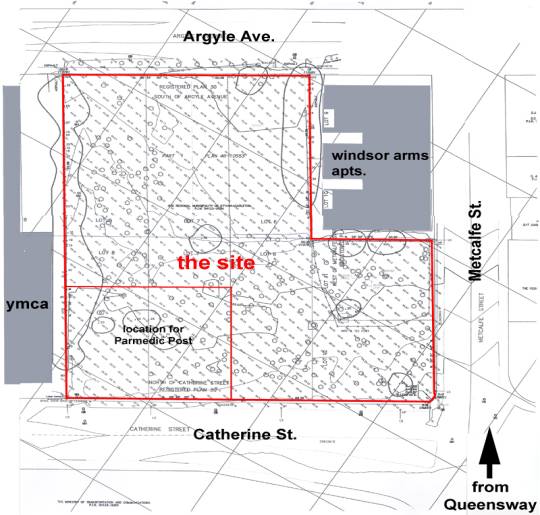
In July 2007, the Community and Protective Services Committee approved a proposal by the CCOC to build 100 affordable housing units on the site (approved by Council here). Even then, there was no detailed site plan, only an outline of the site, with a square in the corner marked "location for Paramedic Post" (at right).

This was the first opportunity for a developer or architect to look at the existing site layout and see where the Paramedic Post would fit in with the proposed number of units.

It wasn't until May of 2008 when the detailed design was presented to the Local Architectural Conservation Advisory Committee (PDF of proposed design). Detailed 3-D renderings are available online, as is an interactive plot of current, Phase I, and Phase II site plans. Remarkably, the CCOC's design proposal appears to include over 250 units, 175 of which qualify as affordable housing.

In Phase I, they will build a new building with 105 apartments and a new paramedic post on the ground floor. In Phase II, they will demolish the old paramedic post and build another building along Catherine Street.

Other virtues of the project put the nail in the coffin on the "wasting taxpayer dollars" argument. According to this proposal (PDF) for the project, Phase II expects a similar investment from the City of Ottawa as Phase I, except they will not need the City's $30,000 per door capital grant. They are also budgeting $56,000 for public art, and are making a number of inroads in sustainable development, including construction to LEED Silver and/or Gold standards, partnership with Vrtucar, and of course its neighbours the YMCA and BUGS.

After a careful and thorough analysis, I think that Council made a prudent decision at the time, and in retrospect, the investment in the safety of citizens was not excessive compared to any alternatives. When all is said and done in 2009, $700,000 will have been spent, $600,000 of it directly by the City, and we will have had the services a Paramedic Post for five years, situated in brand new facilities.

But then, it's easier to just scream "WASTE!", isn't it? Shame on the Sun and CBC for kowtowing to sensationalists and highlighting their misrepresentations in headlines and giant print.