Showing posts with label Commissioner. Show all posts

Monday, May 24, 2021

Wellington Street Part 7: Dawn of "Modern" Transportation Planning in Ottawa

Part 7: Dawn of "Modern" Transportation Planning in Ottawa

   [Show/Hide Contents]

If A.E.K. Bunnell's 1946 report covered in Part 5 recommended a few tweaks to the road network, and the 1949 Gréber report we looked at in Part 6 reimagined large swathes of the City's buildings and transportation network, a January 1955 report report on traffic and transportaion in Ottawa by consultants Wilbur Smith & Associates came in somewhere in the middle. No renamings or disconnections of Wellington Street in this installment, this time we're going on full traffic nerd mode.

This 245-page report1 took a detailed snapshot of traffic in Ottawa, and made a number of specific recommendations, many of which involved Wellington Street. In today's part of the Wellington Street blog series, we'll dive into this report and see what it had to say about traffic in general, and Wellington in particular, in the mid-1950s.

Image of the blue cover of the spiral-bound report in the Ottawa Public Library's Ottawa Room

Sunday, April 25, 2021

Wellington Street Part 6: Postwar traffic on Wellington

Part 6: Postwar traffic on Wellington

   [Show/Hide Contents]

Back in January 2020, we left off with Part 5, in which we watched traffic get heavier on Wellington Street from the 1910s to the 1940s. After a hiatus to do more research and life getting in the way, we're now back to look at government interventions in and around Wellington Street in the ten years following the end of World War II.

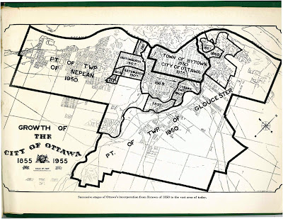
The biggest change for the City of Ottawa was on January 1, 1950,1 when Ottawa annexed nearly all nearby developed area, including Westboro, Ottawa West, Hampton Park, Highland Park, Woodroffe, Laurentian View, McKellar, Britannia, etc. Thich comprised 7,420 acres (3,000 hectares or 30 square kilometres) of Nepean and Gloucester Townships,2 as seen in the two large sections on the map below.3 Much of this was burgeoning suburban development which fed a daily stream of workers into downtown Ottawa.

Map of City of Ottawa from 1955 showing annexations/expansions up to that point, starting with Town of Bytown 1850 City of Ottawa 1855 in the middle and the largest expansions reading Pt of Twp of Nepean 1950 and Pt of Twp of Gloucester 1950.

Although Richmond Road was thus brought into the City limits, it retained its name west of Western Avenue, where Wellington ends.4 Since there were no major physical changes to Wellington Street specifically in this period, today's post will look at traffic in general on Ottawa's Wellington Street.

Wednesday, January 29, 2020

Wellington Street Part 5: Tinkering with traffic (1910s to 1940s)

   [Show/Hide Contents]


Let's continue with our journey exploring Wellington Street as the street was extended, renamed, and rerouted over its 200-year history. In today's post, we'll look at the many little clues that give us an idea of what traffic was like on Wellington Street from the 1910s to the mid 1940s.

During this time, Wellington street wasn't extended or curtailed, but traffic in the city got busier as more people drove automobiles and the City's response to this traffic problem had to mature to cope with it. To set the scene, here's LeBreton Flats from around 1930, with Wellington Street coming in from the left and winding up through to downtown:1

Black-and-white aerial photo taken from above Preston and Somerset with LeBreton Flats, Chaudière and Victoria Island, and Hull at left, and Somerset/Booth, Bronson/Laurier, and the Parliament buildings on the right. The Alexandra/Interprovincial bridge crosses the Ottawa River at the top. From the left near the bottom Wellington Street comes in and splits at Broad Street with Albert continuing straight and Wellington turning left at a shallow angle. On the north side of Wellington, west of Broad, is the Marine Signals building ('the longest in the British Empire') with trainyards and Nepean Bay beyond, and the blocks abutting Wellington on the South side are occupied by a few large industrial facilities. The other blocks further south are primarily residential.

Wednesday, January 1, 2020

The many traces of Wellington Street - Introduction

You may already know that Ottawa has both a Wellington Street and a Wellington Street West, but it was not always so simple. A man standing at the corner of Scott and Bayview in the pre-smartphone days of the early 2000s asked me for help finding an address on Wellington Street, and I had to confess that I didn't know which of three Wellington Streets to direct him to!


I was reminded of this recently and got curious about when these various geometric and name changes took place. I already knew that the City of Ottawa renamed many streets, including two of the Wellingtons, following amalgamation in 2001, and a quick look at an aerial photo reveals clues to how various physical changes broke Wellington Street up. Dennis Van Staalduinen tried his best to explain it on a couple of Jane's Walks in 2012 and 2013, the notes of which he has posted on his website, and a follow-up map in 2016. I even covered the topic myself in a 2010 blog post!

Photo of a green highway-style sign reading Wellington East and pointing to the right

But these were all snapshots; I wanted the whole story. I searched my own collection of books on LeBreton Flats, Ottawa, and the NCC, and found nothing describing the actual changes to Wellington Street. I searched the Web as well, but found only the most recent changes. It turns out that anybody who's written about LeBreton Flats has been more interested in the buildings, people, and land, than on the nomenclature and alignment of its primary artery! (I jest; this is entirely reasonable)

So I took a few trips to the Ottawa Room, bought a subscription to Newspapers.com, and collected a trove of information about Wellington Street, with many twists and turns along the way. Changing names and alignments is a Wellington Street tradition that goes back to the early 1800s and most recently this past September!

Over the past two months, I've painstakingly assembled this information into the following blog series to detail everything I can find out about Wellington Street—everything, that is, except for the buildings, people, and land! Depending on how you count it, Wellington Street was officially renamed between 7 and 21 times, and that doesn't even count all the times where it got physically disconnected or redirected! I've done my best to filter out the wrong information and provide sources for the rest; corrections are welcome by email, tweet, or comment (all comments are moderated).

The first part goes up tomorrow at noon, and the rest of the 10+ parts are in various stages of development and will be posted thereafter. The posts and the headings within them will be added to the bottom of this post as they are added. But first, a quick rundown of Wellington Street:

Monday, September 30, 2013

Bronson reopens for the last time

After two years of construction, Bronson Avenue reopens to through traffic today, whereas it had been closed between Laurier and Somerset (the headline of the linked PSA wrongly states Gladstone). I thought I'd post some snapshots to summarize the progress.


As with last year, the reopening isn't necessarily something to celebrate, as Bronson will no doubt return to its status as a traffic sewer for hasty drivers with little or no connection to Centretown, the roadway is the same width as before the reconstruction (despite the Community's strong desire to get it rebuilt otherwise), but without all the potholes to slow them down. There will hopefully be some degree of relief on the side streets which have been host to cut-through traffic when Bronson was closed.

Recall how disruptive the closure was to road users of all modes. Not only did it disrupt the patterns of people who were just passing through, but when the intersection of Somerset and Bronson was closed, bus riders had quite a walk to get to the nearest bus stop. Customer traffic to the businesses along Bronson slowed to a trickle when Gladstone was closed. There were some attempts to maintain temporary sidewalks for pedestrians also, as seen here in the muddy mess of a street, looking north along the former east sidewalk: