I'm looking mostly at YOU Wellingtons. You are unnatural and should not both exist.— Cassie 🚲🐈 (@cfulgham) August 15, 2016
I was reminded of this recently and got curious about when these various geometric and name changes took place. I already knew that the City of Ottawa renamed many streets, including two of the Wellingtons, following amalgamation in 2001, and a quick look at an aerial photo reveals clues to how various physical changes broke Wellington Street up. Dennis Van Staalduinen tried his best to explain it on a couple of Jane's Walks in 2012 and 2013, the notes of which he has posted on his website, and a follow-up map in 2016. I even covered the topic myself in a 2010 blog post!
But these were all snapshots; I wanted the whole story. I searched my own collection of books on LeBreton Flats, Ottawa, and the NCC, and found nothing describing the actual changes to Wellington Street. I searched the Web as well, but found only the most recent changes. It turns out that anybody who's written about LeBreton Flats has been more interested in the buildings, people, and land, than on the nomenclature and alignment of its primary artery! (I jest; this is entirely reasonable)
So I took a few trips to the Ottawa Room, bought a subscription to Newspapers.com, and collected a trove of information about Wellington Street, with many twists and turns along the way. Changing names and alignments is a Wellington Street tradition that goes back to the early 1800s and most recently this past September!
Over the past two months, I've painstakingly assembled this information into the following blog series to detail everything I can find out about Wellington Street—everything, that is, except for the buildings, people, and land! Depending on how you count it, Wellington Street was officially renamed between 7 and 21 times, and that doesn't even count all the times where it got physically disconnected or redirected! I've done my best to filter out the wrong information and provide sources for the rest; corrections are welcome by email, tweet, or comment (all comments are moderated).
The first part goes up tomorrow at noon, and the rest of the 10+ parts are in various stages of development and will be posted thereafter. The posts and the headings within them will be added to the bottom of this post as they are added. But first, a quick rundown of Wellington Street:
Summary of Wellington Street
Currently, Wellington Street goes from the Rideau Canal in the East, beyond which* is Rideau Street. Wellington goes west past Parliament Hill, past Library and Archives Canada to Portage Bridge, then continues into LeBreton Flats where it ends one block west of Booth Street at Vimy Place, beyond which* is the Sir John A Macdonald Parkway (or "SJAM" for short), which ends at Carling.
(*Beyond their ends, names in 2019 continue to change (literally) down the road: In the east, Rideau Street becomes Montreal Road east of the Rideau River, and then St. Joseph Boulevard through Orleans between highway 174 and Trim Road, before returning to "Old Montreal Road" which parallels and then ends at Highway 174 just before the eastern city limit. In the west, Richmond Road turns into Robertson Road (to which "Old Richmond Road" connects at a right angle) in Bells Corners, and Robertson turns into Hazeldean Road at Eagleson in Kanata South. Old Richmond Road splits off southbound from Robertson where it meets and follows the Jock River before turning west to the former town of Richmond, Ontario, which is now a 'village' in the middle of Ottawa's Ward 21. Through the Village of Richmond, the road is known as Perth St, after which it is called Franktown Road. Before it gets to its terminus at Franktown along Highway 15, it regains the name Richmond Road outside Ottawa's city limits! The SJAM Parkway, aside from having changed its name from Ottawa River Parkway in a surprise political move by the federal government, dutifully retains its name all the way to its terminus at Carling Avenue. ) [hide]
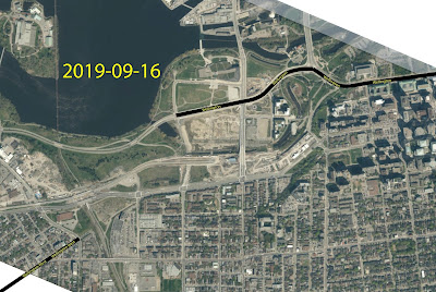
As of September 16, 2019, Wellington Street West goes from Bayview Station Road just west of the O-Train Trillium Line west to Island Park Drive where it turns into Richmond Road. Wellington St West was severed at Somerset during the 2010 reconstruction that I covered in a 15-part blog series, and most of the stub still carries the name Wellington Street West.
This blog series will be focusing on the area between these two, essentially through LeBreton Flats, because that is where most of the changes took place. There will be a detour to look at where Wellington meets Rideau in Part 3.
Up until the late 1960's, Wellington Street (the one going through downtown in the Parliamentary Precinct) continued through the Flats, curving along the aqueduct, then merging with Albert Street until Champagne Street (now City Centre Avenue), until it turned southwest in line with and connecting to the present Wellington Street West. Then, as now, Wellington Street turned into Richmond Road in the west end near Island Park Drive.
To connect over the CPR tracks (which were not sunken into a trench until 1965), Wellington Street went over a viaduct. As Dave Ashton writes in his Kitchissippi Museum blog,
from 1909 until 1969, this [viaduct] was the eastern link [of Hintonburg/West Ottawa] to downtown Ottawa. [...] It had a total length of 1,150 feet, including 550 feet of steelwork and 600 feet of approaches. It was 38 feet wide, with 30 feet of roadway and 8 feet of sidewalks. It was built at a cost of $75,000 in 1909, opening on December 23rd of that year, until it closed on August 13th, 1969.
Here's a photo of the Viaduct in 1940, from Urbsite:
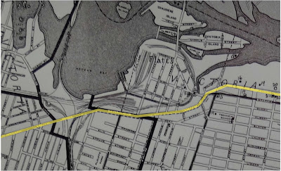
From the 1960s through the 1980s, various changes chopped up Wellington Street, including the removal of the viaduct and the completion of the Ottawa River Parkway, Portage Bridge, and Transitway. By the end of the millennium, there three (I'd argue more) disconnected segments of road called "Wellington Street", as shown in this 2004 report:
How did it all get this way? That's a bit of a longer story.
Join me over the next series of posts as we explore the history of Wellington Street in nitty-gritty detail. As I finish and publish the posts, I'll add links and summaries below. I hope to have them all published by the end of January.
Wellington Street: List of posts
Introduction (this post)
Part 1: Ottawa's earliest roads and their namesakes
[Show/Hide Part 1 headers]
Part 2: The west end's Muddy Trails to street rails (1828-1870s)
Part 3: Wellington and Rideau's on again, off again, connection (1820s-1913)
Part 4: As the City grows, so does Wellington (1880-1912)
- 1880 Renaming of George Street, Victoria Terrace, and Richmond Road
- Railway Crossings
- Great big fires
- 1908 Renaming of Richmond Road through Hintonburg
- Wellington Street Vidauct
- Wellington widening and paving through Hintonburg
- Clearing up the 'middle section' of Wellington
- 1912 Re-renaming of George Street and Victoria Terrace
Part 5: Tinkering with traffic (1910s to 1940s)
Part 6: Postwar traffic on Wellington
Part 7: Dawn of "Modern" Transportation Planning in Ottawa
Part 8: Viaduct traffic, Journaled
- History written by the whiners
- 'Battle of the Bridge'
- Bayview slip lane
- Westward city growth gets the wheel squeaking again
- Viaduct repairs 1920s to 1950s
- Wellington Bridge is Falling Down 1960s
- New Wellington Viaduct to be built
- Wellington Street Officially Severed
- 'Replacement' viaduct will disconnect Wellington
- Reaction to Wellington disconnection
- Demolition of the Wellington Street Viaduct
Part 9: The NCC's distractions (early-mid 1960s)
Part 10: Nepean Bay and the Ottawa River Parkway
Part 11: Portage Bridge
Part 12: 50 Years of Rapid Transit in Ottawa
Wellington Street Part 13: The Transitway
2025?
...more to be added here as I prepare them! (There will be ~15 in total)
I've done my best to filter out the wrong information and provide sources for the rest; corrections are welcome by email, tweet, or comment (all comments are moderated).


Great series of articles! I wanted to know where, officially, Richmond Road started in the east. I hope you're able to continue the posts at some point. Thanks for the research!
ReplyDeleteThanks for the feedback! I made some progress on the next batch of posts in the series back in December, but they still need a bit more work to polish them off when I get some spare time. Glad to know that someone's reading them :)
DeleteYou wrote: “Then, as now, Wellington Street turned into Richmond Road at Island Park Drive.”
ReplyDeleteActually, as you explained elsewhere in this blog series, it then ended at Western Avenue. They scooched in a couple of blocks (west to Island Park) in the name of wayfinding when the “Wellington Street West” name was created, post-2000.
Quite right. Thanks for catching my slip up!
Delete