Wednesday, January 29, 2020
Wellington Street Part 5: Tinkering with traffic (1910s to 1940s)
View other posts on these topics:
Albert,
Broad St,
Bronson,
Commissioner,
Hintonburg,
LeBreton Flats,
Parking,
Pedestrians,
Planning and Development,
Preston,
Roads,
Streetcars,
Traffic,
Wellington
Let's continue with our journey exploring Wellington Street as the street was extended, renamed, and rerouted over its 200-year history. In today's post, we'll look at the many little clues that give us an idea of what traffic was like on Wellington Street from the 1910s to the mid 1940s.
During this time, Wellington street wasn't extended or curtailed, but traffic in the city got busier as more people drove automobiles and the City's response to this traffic problem had to mature to cope with it. To set the scene, here's LeBreton Flats from around 1930, with Wellington Street coming in from the left and winding up through to downtown:1
Monday, January 13, 2020
Wellington Street Part 4: As the City grows, so does Wellington (1880-1912)
View other posts on these topics:
CHP,
City Centre,
Dalhousie,
Fire,
Hintonburg,
LeBreton Flats,
Preston,
Richmond,
Roads,
Streetcars,
Wellington
- 1880 Renaming of George Street, Victoria Terrace, and Richmond Road
- Railway Crossings
- Great big fires
- 1908 Renaming of Richmond Road through Hintonburg
- Wellington Street Vidauct
- Wellington widening and paving through Hintonburg
- Clearing up the 'middle section' of Wellington
- 1912 Re-renaming of George Street and Victoria Terrace
- References
Before our foray into the east end of Wellington Street in the previous post, we were talking in Part 2 about the first roads in Ottawa and how the fledgling town's road network began to develop in the new neighbourhood that would one day be called LeBreton Flats.
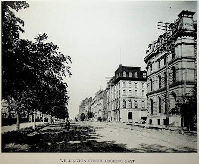
In this post we'll look at the period from about 1880 to 1912, during which time rail lines cross over Wellington at grade, fires ravage the western part of the street, Ottawa absorbs various suburbs, and an excessive number of bylaws authorize the renaming, widening, and paving of Wellington Street. To set the scene, here's what it looked like to walk in the middle of Wellington Street in 1898:1
Wednesday, January 8, 2020
Wellington Street Part 3: Wellington and Rideau's on again, off again, connection (1820s-1913)
View other posts on these topics:
Canal,
CHP,
Parliamentary Precinct,
Rideau,
Roads,
Sparks,
Wellington
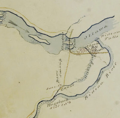
In this blog series about 200 years of physical and nominal changes to Wellington Street, most of the action is West of Bank Street, particularly in LeBreton Flats. The previous post showed the earliest of these changes. Today we will examine the changes to the east end of Wellington Street in the 1800s, as it dabbled with connections to Rideau.
Monday, January 6, 2020
Wellington Street Part 2: The west end's Muddy Trails to street rails (1828-1870s)
View other posts on these topics:
LeBreton Flats,
Roads,
Streetcars,
Victoria Island,
Wellington
In the previous post, we drew lines from the Dukes of Richmond and Wellington and connected them to the roads bearing their names in Ottawa via the Earl of Dalhousie and Colonel By. We ended with Colonel By establishing By Town and laying down Wellington and Rideau Streets in Upper Town and Lower Town, respectively.
Today we continue the saga of Ottawa's Wellington Street and start to look at its earliest connections with other roads and the names they've had. We'll be focusing on the western end of Wellington Street as it skirts around the edge of LeBreton Flats. (The full list of posts is in the Introductory post in this series, populated as each part is posted)
Thursday, January 2, 2020
Wellington Street Part 1: Ottawa's earliest roads and their namesakes (1800-1826)
View other posts on these topics:
CHP,
LeBreton Flats,
Richmond,
Somerset,
Sparks,
Victoria Island,
Wellington
To go beyond a simplified summary and conduct a thorough review of the history of changes to all the roads in Ottawa called "Wellington Street", we need to go back to Ottawa's earliest days as a settlement and where that all came from.
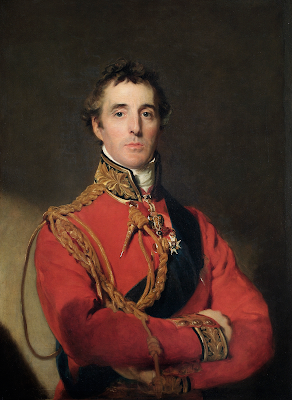
It's easy enough to say "Richmond Road was named after the Duke of Richmond and Wellington Street was named after the Duke of Wellington", but that doesn't answer the questions of who those people are and what relation they bore to Ottawa and to the people who built its first roads. So let's get into that.
It's easy enough to say "Richmond Road was named after the Duke of Richmond and Wellington Street was named after the Duke of Wellington", but that doesn't answer the questions of who those people are and what relation they bore to Ottawa and to the people who built its first roads. So let's get into that.
Wednesday, January 1, 2020
The many traces of Wellington Street - Introduction
View other posts on these topics:
417,
Albert,
Booth St,
Broad St,
CHP,
Cliff St,
Commissioner,
Fleet St,
Introduction,
LeBreton Flats,
NCC,
Portage Bridge,
Roads,
SJAM,
Wellington
You may already know that Ottawa has both a Wellington Street and a Wellington Street West, but it was not always so simple. A man standing at the corner of Scott and Bayview in the pre-smartphone days of the early 2000s asked me for help finding an address on Wellington Street, and I had to confess that I didn't know which of three Wellington Streets to direct him to!
I was reminded of this recently and got curious about when these various geometric and name changes took place. I already knew that the City of Ottawa renamed many streets, including two of the Wellingtons, following amalgamation in 2001, and a quick look at an aerial photo reveals clues to how various physical changes broke Wellington Street up. Dennis Van Staalduinen tried his best to explain it on a couple of Jane's Walks in 2012 and 2013, the notes of which he has posted on his website, and a follow-up map in 2016. I even covered the topic myself in a 2010 blog post!
But these were all snapshots; I wanted the whole story. I searched my own collection of books on LeBreton Flats, Ottawa, and the NCC, and found nothing describing the actual changes to Wellington Street. I searched the Web as well, but found only the most recent changes. It turns out that anybody who's written about LeBreton Flats has been more interested in the buildings, people, and land, than on the nomenclature and alignment of its primary artery! (I jest; this is entirely reasonable)
So I took a few trips to the Ottawa Room, bought a subscription to Newspapers.com, and collected a trove of information about Wellington Street, with many twists and turns along the way. Changing names and alignments is a Wellington Street tradition that goes back to the early 1800s and most recently this past September!
Over the past two months, I've painstakingly assembled this information into the following blog series to detail everything I can find out about Wellington Street—everything, that is, except for the buildings, people, and land! Depending on how you count it, Wellington Street was officially renamed between 7 and 21 times, and that doesn't even count all the times where it got physically disconnected or redirected! I've done my best to filter out the wrong information and provide sources for the rest; corrections are welcome by email, tweet, or comment (all comments are moderated).
The first part goes up tomorrow at noon, and the rest of the 10+ parts are in various stages of development and will be posted thereafter. The posts and the headings within them will be added to the bottom of this post as they are added. But first, a quick rundown of Wellington Street:
I'm looking mostly at YOU Wellingtons. You are unnatural and should not both exist.— Cassie 🚲🐈 (@cfulgham) August 15, 2016
I was reminded of this recently and got curious about when these various geometric and name changes took place. I already knew that the City of Ottawa renamed many streets, including two of the Wellingtons, following amalgamation in 2001, and a quick look at an aerial photo reveals clues to how various physical changes broke Wellington Street up. Dennis Van Staalduinen tried his best to explain it on a couple of Jane's Walks in 2012 and 2013, the notes of which he has posted on his website, and a follow-up map in 2016. I even covered the topic myself in a 2010 blog post!
But these were all snapshots; I wanted the whole story. I searched my own collection of books on LeBreton Flats, Ottawa, and the NCC, and found nothing describing the actual changes to Wellington Street. I searched the Web as well, but found only the most recent changes. It turns out that anybody who's written about LeBreton Flats has been more interested in the buildings, people, and land, than on the nomenclature and alignment of its primary artery! (I jest; this is entirely reasonable)
So I took a few trips to the Ottawa Room, bought a subscription to Newspapers.com, and collected a trove of information about Wellington Street, with many twists and turns along the way. Changing names and alignments is a Wellington Street tradition that goes back to the early 1800s and most recently this past September!
Over the past two months, I've painstakingly assembled this information into the following blog series to detail everything I can find out about Wellington Street—everything, that is, except for the buildings, people, and land! Depending on how you count it, Wellington Street was officially renamed between 7 and 21 times, and that doesn't even count all the times where it got physically disconnected or redirected! I've done my best to filter out the wrong information and provide sources for the rest; corrections are welcome by email, tweet, or comment (all comments are moderated).
The first part goes up tomorrow at noon, and the rest of the 10+ parts are in various stages of development and will be posted thereafter. The posts and the headings within them will be added to the bottom of this post as they are added. But first, a quick rundown of Wellington Street:
Subscribe to:
Comments (Atom)


