Showing posts with label Hintonburg. Show all posts

Tuesday, August 17, 2021

Wellington Street Part 8: Viaduct traffic, Journaled

Part 8: Viaduct traffic, Journaled

   [Show/Hide Contents]

Although I set out in October 2019 to write this Wellington Street blog series looking to learn about the street's various connections and disconnections, the last three parts, ending with a look at a 1950s traffic study were a bit of a sidetrack.

The last connection change was back in Part 4 when the Wellington Street Viaduct was built in 1909 (overtop an existing route). As it happens, the next major change to Wellington Street that we'll look at is when the viaduct was replaced.

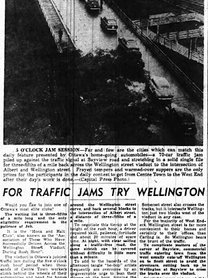
The Viaduct gets an entire post thanks to the Ottawa Journal's obsession with its role as a bottleneck for afternoon rush-hour traffic.1

1940s Newspaper article with heading For Traffic Jams Try Wellington, with a bird's eye photo of a line of cars on the Wellington St Viaduct, captioned 5 O'Clock Jam Session.

Sunday, April 25, 2021

Wellington Street Part 6: Postwar traffic on Wellington

Part 6: Postwar traffic on Wellington

   [Show/Hide Contents]

Back in January 2020, we left off with Part 5, in which we watched traffic get heavier on Wellington Street from the 1910s to the 1940s. After a hiatus to do more research and life getting in the way, we're now back to look at government interventions in and around Wellington Street in the ten years following the end of World War II.

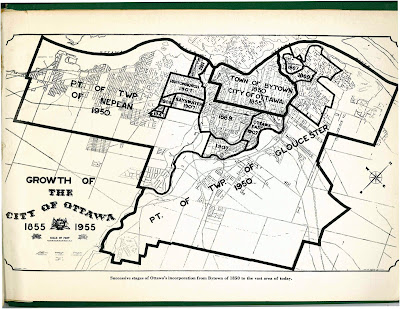
The biggest change for the City of Ottawa was on January 1, 1950,1 when Ottawa annexed nearly all nearby developed area, including Westboro, Ottawa West, Hampton Park, Highland Park, Woodroffe, Laurentian View, McKellar, Britannia, etc. Thich comprised 7,420 acres (3,000 hectares or 30 square kilometres) of Nepean and Gloucester Townships,2 as seen in the two large sections on the map below.3 Much of this was burgeoning suburban development which fed a daily stream of workers into downtown Ottawa.

Map of City of Ottawa from 1955 showing annexations/expansions up to that point, starting with Town of Bytown 1850 City of Ottawa 1855 in the middle and the largest expansions reading Pt of Twp of Nepean 1950 and Pt of Twp of Gloucester 1950.

Although Richmond Road was thus brought into the City limits, it retained its name west of Western Avenue, where Wellington ends.4 Since there were no major physical changes to Wellington Street specifically in this period, today's post will look at traffic in general on Ottawa's Wellington Street.

Wednesday, January 29, 2020

Wellington Street Part 5: Tinkering with traffic (1910s to 1940s)

   [Show/Hide Contents]


Let's continue with our journey exploring Wellington Street as the street was extended, renamed, and rerouted over its 200-year history. In today's post, we'll look at the many little clues that give us an idea of what traffic was like on Wellington Street from the 1910s to the mid 1940s.

During this time, Wellington street wasn't extended or curtailed, but traffic in the city got busier as more people drove automobiles and the City's response to this traffic problem had to mature to cope with it. To set the scene, here's LeBreton Flats from around 1930, with Wellington Street coming in from the left and winding up through to downtown:1

Black-and-white aerial photo taken from above Preston and Somerset with LeBreton Flats, Chaudière and Victoria Island, and Hull at left, and Somerset/Booth, Bronson/Laurier, and the Parliament buildings on the right. The Alexandra/Interprovincial bridge crosses the Ottawa River at the top. From the left near the bottom Wellington Street comes in and splits at Broad Street with Albert continuing straight and Wellington turning left at a shallow angle. On the north side of Wellington, west of Broad, is the Marine Signals building ('the longest in the British Empire') with trainyards and Nepean Bay beyond, and the blocks abutting Wellington on the South side are occupied by a few large industrial facilities. The other blocks further south are primarily residential.

Monday, January 13, 2020

Wellington Street Part 4: As the City grows, so does Wellington (1880-1912)

   [Show/Hide Contents]


Before our foray into the east end of Wellington Street in the previous post, we were talking in Part 2 about the first roads in Ottawa and how the fledgling town's road network began to develop in the new neighbourhood that would one day be called LeBreton Flats.

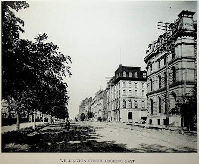
In this post we'll look at the period from about 1880 to 1912, during which time rail lines cross over Wellington at grade, fires ravage the western part of the street, Ottawa absorbs various suburbs, and an excessive number of bylaws authorize the renaming, widening, and paving of Wellington Street. To set the scene, here's what it looked like to walk in the middle of Wellington Street in 1898:1

Photo taken from Wellington Street, looking east, at around O'Connor Street, with the street extending into the horizon. From left to right: The stone and wrought iron fence at the perimeter of Parliament Hill, the north sidewalk (material unclear), a boulevard planted with a continuous row of trees, the roadway which is dirt and rutted, a bicyclist in the road heading straight toward the camera, a horse drawn carriage further away on the opposite side of the street, telephone poles each with nine rows of eight insulators, the south sidewalk (concrete?) with some trees, buildings on the south side of Wellington Street, all around 4 storeys tall. The photo has an all-caps caption at the bottom (from the book from which it was scanned), Wellington Street Looking East

Thursday, June 27, 2013

3D Thursday: Hydro pole hole

In advance of the upcoming reconstruction of Gladstone Avenue starting this summer, Hydro Ottawa is replacing the hydro poles along Gladstone from Cartier to Bank. Here, five buckets hoisted by three cherry picker trucks are holding workers as they anchor the fixtures for a replacement pole at O'Connor:


It's a tricky job, because they need to put the new pole in right next to the old one, dodging the wires along the way. To do this, they need to dig a hole for the new pole, using a big 'badger' vacuum truck. I took a 3D photo looking down into one of these holes:

Source photos for the 3D images:
Left, Right

In case you're wondering how deep those wooden poles go beneath the ground, here's a pole on Wellington West in Hintonburg where they dug out underneath the sidewalk, leaving the pole and sidewalk in place:


Since I know you're wondering, construction on Gladstone isn't supposed to start until mid-July at the earliest.

[Tune in on Thursdays at noon for a new 3D image. View the 3D label for other posts with 3D images. 3D FAQ]

Monday, April 9, 2012

Somerset Street Reconstruction Part 10: City Centre

In the previous part of the 15-part series on the 2011 reconstruction of Somerset Street West, I rounded out the reconstruction of the roads and sidewalks. But there is another project tied into it, the north-south pathway along the O-Train corridor. Much of this corridor goes along the City Centre complex and it's worthwhile to take a minute to make a brief tour around the complex before talking about the pathway in the next post.

The complex, officially 250 City Centre Avenue, is comprised of an office tower and industrial bays that span from Albert Street to Somerset Street West along the O-Train line. For many years its dingy white sides and illuminated red lettering were a familiar eyesore to residents of Ottawa, as seen here in a photo from September 2008:

Friday, March 23, 2012

Somerset Street Reconstruction Part 7: Trees & bike racks

We've had some very summer-like weather the last few days, and the bike counter on the Laurier segregated bike lane registered 1519 cyclists on Wednesday, 2/3 of the highest daily number ever counted at that location!

That makes a good opportunity to talk about the trees and bike racks in this installment of the 15-part series on the reconstruction of Somerset Street West. Previously, in part 6 the subject was poles and signals.

Ging Sing Chinese restaurantIn the seventeen meetings of the design committee, great persistence by the community representatives and creative thinking all around enabled many more trees to be fit into the design. A particular challenge was getting trees on the viaduct/bridges by the City Centre building, because the drainage patterns make a challenging environment for trees' chance of survival. The solution is described in the next post in the series, part 8*, but this preliminary diagram gives an idea of how many more new trees (the dark green circles) will be added to join the old ones (lighter green circles):

Monday, November 7, 2011

A Sidewalk Too Far

You'd think it would be easy enough to get from point A to point B, but sometimes in Ottawa you have to go through point C to get there.

I don't mean this metaphorically, but literally. In the diagram below, desire lines (a.k.a. "cowpaths") indicate that pedestrians want to get from A to B, but the sidewalk directs them to go from A to C to B. It's actually worse than this, which is why I'm showcasing it as an example for Diane Holmes' Sidewalk Summit, this Tuesday at 7pm at City Hall.

The story starts at Tom Brown arena in Hintonburg, where Albert and Scott Streets meet on the west side of the O-Train tracks. Last Tuesday, Citizens for Safe Cycling had its Annual General Meeting there and bike parking was at a premium (many had already left by the time I took this photo. At one point, every bench, tree, and signpost had a bike locked to it).

Friday, December 10, 2010

West Side from above

I've run out of time this weekend to prepare posts for this week (busy preparing for Tuesday's CCCA meeting), so instead of posting many photos of the same building, I'll post one photo of many buildings. Forgive me if most of them aren't in Centretown.

Taken from the top floor of Queen Elizabeth Towers, 500-530 Laurier in March at rush hour (click to see full size):

There's the Stonecliffe apartments and the Ottawa Builders' Exchange (now Ottawa Construction Association) headquarters on Bronson Avenue, St. Vincent hospital (Bruyère centre), the Dominican college, the Oak Street government warehouse, City Centre building (after the letters were removed but before it was repainted) and the Somerset Street bridge, Albert Street to Scott Street, Bayview transit station...

More distant items are visible, too. The Queensway on the left, Minto's Metropole condo tower (the tallest building in Ottawa), Holland Cross, and more condos on Richmond Road that I recognize but can't name. The Rideau River is also visible, but far out around Britannia Bay.

Which other buildings and landmarks can you recognize?

[Look for more one-photo posts under the label Singles]

Friday, September 3, 2010

Bowling on Wellington

This is in Hintonburg, on Wellington Street West, but noteworthy nonetheless. On a June trip on the newly re-opened Wellington Street West, I noticed that the "G" on this sign has finally been replaced.

For quite a long time, West Park Bowling's large white-on-black letters spelled out only "B-O-W-L-I-N"--here's proof, from last August (this cropped image is the best photo of it I could find in my collection):

I believe this is the nearest place to Centretown to go bowling since the Kent Bowling Lanes on Catherine closed down and got converted to mini-storage. I remember they used to have disco bowling:

[Hm... I was going to give this post the label Singles, but there are two photos too many!]

Thursday, July 8, 2010

Wellington Street, meet Wellington Street

With the current debate on the suggestion renaming Wellington Street in front of Parliament Hill after Sir John A. Macdonald, lots of people are wondering why we've got two Wellington Streets.

We actually had three of them: the third was that stretch that connects Scott Street to Albert/Slater, a section that is now called Albert Street. As seen in the map below, this stretch in 1894 was called Richmond Road (because the road went to Richmond, Ontario), so that stretch has had at least four different names to it! (I'll talk more about this map further down)

At one point they were connected, technically just one Wellington Street--not two or three. The roadway connecting Albert Street in Lebreton Flats to Wellington Street in front of Parliament Hill is still there, off Commissioner Street, but little used. It has a sign advertising the sidewalk as a shared sidewalk for cyclists, presumably dating from when there was regular motor traffic along there. At the end of it is Wellington Street coming off the Portage bridge, with the Library and Archives Canada square in front of us:

Before Lebreton Flats was razed, there was a bridge over the O-Train tracks connecting the 'middle' Wellington Street to what is now known as Wellington Street West. Here's a photo of that bridge from the Gréber report, with the bridge crossing the image. Behind it, you can also see the Prince of Wales railway bridge over Lemieux Island to Gatineau.

A similar view today, taken from the Somerset Street bridge looking North (bonus glamour shot of the O-Train). Where the track turns right is where the track turns right in the above photo. All the other tracks and buildings have been removed:

The right-of-way for this bridge is still there, going along the North edge of the City Centre building. In the photo below, looking West-ish, the City Centre building is at the left. The O-Train tracks are ahead (not visible), and we can see straight down Wellington West in Hintonburg. After a few blocks, it connects with Somerset Street West.

This isn't very intuitive, because Scott Street connects pretty much in line with Wellington/Albert, doesn't it? Well, Ottawa--even downtown Ottawa--is an agglomeration of a bunch of small villages and neighbourhoods that sprouted up pretty independently. The 1894 street map above (taken from this post on URBSite) shows duplicate street names (like two perpendicular "Arthur"s just blocks apart), often named in different neighbourhoods for the same royalty. Even by this time, the disparate road networks were connected, but it has led to some pretty strange intersections (e.g. pretty much any street crossing Bronson).

How does this look big-picture? Well that bridge is on the right in this aerial photo from May 1960. At the left is Nepean Bay, which is much smaller today than it was at the time. If you were to superimpose the Transitway, Ottawa River Parkway and pathways onto this photo, they would go right through the water. This is because it was filled in in the 60's or 70's for various city-building projects. The fill used was landfill (i.e. garbage), which is one of the main reasons it's so hard to get anything built there.

Also visible in the photo is the old Canadian Pacific Roundhouse, Lebreton Flats pre-demolition, the temporary buildings on the site now occupied by the Library and Archives Canada, the Alexandra (interprovincial) bridge in the background and buildings pre-dating the Canadian Museum of Civilization, and various former and existing landmarks.

And all this to explain why we've got two Wellington Streets.

PS: Those who want to rename Wellington after Macdonald and/or Cartier should know that we've already got a street named after Macdonald, running parallel to Cartier in the Golden Triangle, between Somerset and Frank: [Edit: It is observed by a commenter that the capitalization of that street is incorrect.]