Showing posts with label Bank. Show all posts

Monday, February 10, 2014

Snow removal on Bank Street (video)

On the left, the snow accumulation on Bank Street's west sidewalk from the previous snowfall. On the right, the mostly-bare road and sidewalk minutes after the City took the same snowbanks away from the east side of Bank Street last night:


I described the process in more detail in my 2012 post, "Snow removal on Kent." In summary, some very deft sidewalk plow operators push the snow from around various obstacles on the sidewalk into the road. Then graders like this one go by to arrange this snow into a straight row on the roadway:


Then, of course, the big snow blower machine comes by to whisk the snow (and ice!) all away with ease, while a lineup of trucks follow in wait of their turn to collect the snow from the blower:


I took a video of the blower going by. Watch it in stunning HD:


As described at a briefing last week at the City's Transportation Committee, snow removal (that is, physically removing it from the road and taking it someplace else, as opposed to snow clearing, which is just pushing it aside) makes up the biggest part of the City's winter maintenance budget. Of the $11.8M spent to clean up after the December 20 storm, most ($7.2M) was spent on snow removal. By contrast, $873,000 was spent on sidewalk clearing during and after that storm, which amounts to about a dollar per person for that one storm.

Wednesday, February 5, 2014

Peds on Weds: Part 4: A history of sidewalk design in Ottawa

Today for the fourth and final entry of the sidewalk-design series, I'm going to give a history of sidewalk design, starting at the establishment of the original City of Ottawa, in 1855 (and earlier!). In part 2 of this series, I already gave a "little history" of the Toronto-style sidewalk design, relating specifically to how they became standard back to the establishment of the current amalgamated City of Ottawa in 2001. This followed part 1, in which I described "Toronto-style" sidewalks and the problems they're meant to address, and part 3, in which I discussed some of the issues the Toronto-style sidewalk itself has faced.

Today's entry starts with the West Ward Market, built in 1848 by Nicholas Sparks. This was used as Ottawa's first City Hall, roughly where the NAC is today.

r

The first municipally-built sidewalks in Ottawa actually predate the City of Ottawa's 1855 incorporation: by-law number 37 of the Town of Bytown, approved the 23rd of September, 1850, was "To authorize the expenditure of £75 in making a Plank Sidewalk, S. side York Street":

Monday, February 3, 2014

Flashy bike

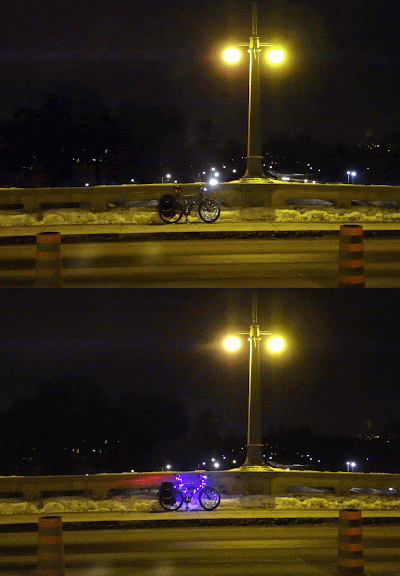
Near the end of December as the Rideau Canal skateway was agonizingly close to opening, I went on a Bike Ride along the canal one night to take some photos of the canal. With my bike resting on one side of the Bank Street bridge, I took a picture of it. Realizing I'd accidentally got it when the flashing purple lights were off, I took another. At the suggestion of a friend, I made it into an animated gif, and it works pretty well!


[Look for more one-photo posts under the label Singles]

Monday, December 2, 2013

Lifting Centretown's Spirits

Yes, there are decorations on streetlamps, lights in store windows, and powdery white snow on the ground, but last week's opening of the new LCBO at Bank and McLeod has not just spirits, but also wine and beer.


Ottawa Citizen columnist Joanne Chianello sparked a twitter conversation earlier this month about the location, and the relatively uncommon location of this LCBO at the base of a condo tower (certainly unprecedented in Ottawa).

A spin-off twitter conversation by Metroland's Laura Mueller sparked a discussion about the impact of this location on the other nearby LCBO locations. CBC's Giacomo Panico pointed out that this location was moving from 240 Sparks ... LCBO store locator [Edit: I got some stuff wrong here earlier. Fixed now, I think.]

Meanwhile, the LCBO 7 blocks down Bank Street in the Glebe, which would be visible from the Bank and McLeod location if not for the Queensway, isn't going anywhere anytime soon, apparently. (Sadly, all three of the large ash trees in front of that location succumbed last year to the Emerald Ash Borer beetle infestation).

Equidistant from those two locations, the LCBO next to the Loblaws on Pretoria is being rebuilt in the location of the former Beer Store (which, by contrast, is closed permanently) with nothing but air above it.

There is also supposed to be an LCBO at the new Lansdowne Park big box plaza/mall.


There's a lot I can't comment on by the mere fact that I don't drink alcoholic beverages, but it's still an interesting case study in terms of, "what do you put in a mid-size mainstreet commercial space when there's already a Shopper's Drug Mart only a block away?"

[Look for more one-photo posts under the label Singles]

Monday, November 18, 2013

Bad sectors in Centretown

Back in July, my hard disk drive crashed, losing two months' worth of photos (about 1600). At the end of October I got a surprise call from the guy I'd brought it to, who said he was able to recover over 90% of the data. I was able to push this to about 97% of the photos that I had taken since my previous backup.

Some of them, however, were damaged. The hard drive had bad sectors and in the recovery many of the photos were damaged (only a very small number were completely unreadable). The damage inflicted on them actually has a bit of an artistic tone to them. Here's a photo of 222 Queen Street (which is where the RMOC headquarters were before it moved to the building that's now City Hall):


I discovered that I actually had a more recent backup on an external drive, up to mid-June. From this, I was able to push the recovery rate to about 99% of my photos, since many of the damaged photos were taken before then. Here's the original of the photo above:

Wednesday, November 6, 2013

Metropolitan Centretown

Looking south at Bank and Gladstone on a rainy dusk in early September. (Sigh, at a quarter to 8pm!)


I'm not particularly fond of the development here, nor the way the former Metropolitan Tabernacle's façade has be entirely de-animated as it has succumbed to death-by-Shoppers. But because the building is so close to the street, the developer was forced to bury the power lines. That on its own is a plus, but in addition it has meant full-fledged streetlights instead of the light heads tacked on to wooden hydro poles.

I suppose that arguably there is a pedestrian component to that to warrant adding "Peds on Weds" to the title of this post, but really I just wanted to post this picture because I like the colours.

[Tune in on Wednesdays at noon for a new pedestrian-themed blog post. View the Pedestrians label for previous Peds on Weds posts]
[Look for more one-photo posts under the label Singles]

Friday, September 27, 2013

Autumn in Centretown

The brown-tinged leaves of the ginkgo tree are one of the signs of fall.


As you could probably tell, though, this photo isn't from the current season, with the tower crane for the Centropolis condos in the background. It's from mid-October 2011, so we still have some time to enjoy a touch of good weather here or there. And even in mid-October, the flower shop/café had its patio chairs set out.

[Look for more one-photo posts under the label Singles]

Thursday, July 25, 2013

Yellow dots are like loopy buttons for cyclists

(It's been a month since my last post; I'm slowly recovering from a long stint volunteering at RBC Royal Bank Bluesfest where I run the bike parking. This year we had record numbers again!)

A topic I'm eager to write about is the yellow dots on the pavement at intersections. You may recall my epic on pedestrian buttons, No Ifs, Ands or Buttons (and the follow-up supplementary post). Well cyclists have a way of activating the signals too, and what better place to describe it than the brand-new traffic control signal at Bronson and Arlington:


To recap the lowdown on ped buttons: when there is a traffic control signal with buttons, and there is a little yellow sign above the button, that means you must press the button if you want the walk signal to activate (though for some such intersections there might be some times of the day or week when the signal changes on a fixed timing whether or not the button is pressed).

Monday, April 15, 2013

Bixi's back for 2013

As of today, Capital Bixi is back in action! For subscribers like me, that means my key should work for the remainder of my one-year subscription (which I bought last June). And for you readers of my blog, that means I'm going to blog about it!


I never got around to blogging my Bixi photos last year (and the year before, my season-opener blog post used photos from the 2009 pilot), so I get to include some of those with this post. For example, the one above was taken last June at the Museum of Nature's east lawn, at Elgin and McLeod. On Saturday night, the bikes had been re-installed, though it was decidedly snowier:

Wednesday, November 14, 2012

Peds on Weds: Bench with a view?

The next Walk Ottawa meeting is this coming Monday, November 19, 2012 at 7pm at City Hall in the Honeywell Room. There is much to discuss since a Steering Committee was appointed at the September meeting. If you missed the group's October tour of the City's Traffic Operations Division building, you can relive the experience from a three part blog tour posted after a similar tour of the building in 2009.

Today's pedestrian content involves a curious discovery I made while having lunch this past summer at Burgers on Main. When Somerset Street was rebuilt between Elgin and Kent around 2006, the streetscaping in Somerset Village (the block of old houses-turned-restaurants on Somerset between O'Connor and Bank) included this bench:


The bench seems rather deliberately placed in front of that grey box, which doesn't make for very good viewing (nor does the partially-demolished Somerset House). However there is a lock on the box and it looks like there are doors that open. Maybe there is some sort of video screen inside intended as a forgotten piece of public art?

[Tune in on Wednesdays at noon for a new pedestrian-themed blog post. View the Pedestrians label for previous Peds on Weds posts]
[Look for more one-photo posts under the label Singles]

Friday, October 19, 2012

Five years since Somerset House collapse

While a petition and articles in both the Centretown News and Centretown Buzz have recently suggested that it happened in November 2007, the collapse of the wall at Somerset House in fact happened exactly five years ago, on Friday, October 19, 2007. In this post, which is the longest so far on this blog with 30 photos, I'll go over some of the highlights on and since that day that mark the ongoing saga of the historic building. Given the milestone, I'm publishing at 9am instead of noon.


As the Citizen reported the day after the collapse (I can't link directly to archived Citizen articles; you'll have to log in to the Proquest database with your Ottawa Public Library card and PIN and search for them), a 44-year old Bobcat operator was stuck under rubble for about two hours when the southeast part of the building collapsed on him just before 3pm.

When I got there around 7:30pm, the whole area was taped off by the fire department, and it was raining hard. The Fire Department had connected tethers from the north sidewalk across the street into the building.


An hour later, a large crane arrived on scene. I didn't stay around for much longer, since it looked like work would continue all night.

Monday, October 1, 2012

Winter & Summer across from Snider

Entirely by accident, I managed to take the exact same photo twice, six months apart. Just the tiniest amount of cropping and rotating was needed on these two photos of 353-355-357 Bank Street, on the east side between Laurier and Slater, across from Snider Plaza. Having done that, making an animated GIF of the two images was just irresistible:


From left to right, the stores are BabyFace, Bowitch, Jade Spa, and Kiddytown. It's interesting to see what changes and what doesn't. For example, unchanging are the "Summer Discount" signs in Kiddytown's windows, even in February. Under the 'change' heading, it is possible to see how the weight of the leaves weighs down the branches of the smaller tree.

Since the GIF reduces the image quality, here are the two source photos as JPGs (after rotation and cropping) in case you wanted to play with them. (Picasa 3.8 lets you view two photos side-by-side and zoom in, which is perfect for this). Click them to view/download larger. If you're sufficiently nerdy to want them, you'd probably also like to know that the summer photo was taken in August around 6:30pm, and the winter one in February around 3:30pm.


[Look for more one-photo posts under the label Singles]

Monday, September 24, 2012

Lights out for the night

I recently passed by the station at night (around 10:30 p.m.) and was struck by the unusual absence of its usual blinding lights.


Once when arriving back in Ottawa on an evening flight, I noticed how brightly lit gas stations are. Looking down from over the city, gas stations stick out like sore thumbs, especially in the suburbs where gas stations are big and the streets are fairly dark.

I've since noticed it back on the ground also: every square inch of asphalt on a gas station's property is inundated with light. Normally, the MacEwen Ethanol gas station at Bank and Catherine is no exception—you risk a tan just driving by at night—but on this particular evening, it was refreshing to see them sparing the electricity.

[Look for more one-photo posts under the label Singles]

Wednesday, September 19, 2012

Peds on Weds: L'Es try something different (or not)

Recently some workers have been spotted on Laurier Avenue affixing drywall to the central podium section of the l'Esplanade Laurier office tower:

Stepping back a bit, both literally and figuratively, the building is a full-block structure surrounded by Laurier, O'Connor, Gloucester and Bank streets.

Monday, September 3, 2012

Centretown time capsule: August/September 2007

Happy Labour Day everyone!

For today's post, I want to do something a little different. I wanted to give a snapshot of what was happening in Centretown five years ago in August and September 2007. With a high proportion of renters, many Centretown residents—even those active in community affairs—weren't here five years ago (nor was this blog!). For the rest of us, it'll be a trip down memory lane.

The 2007 Labour Day parade, organized by the Ottawa and District Labour Council, ended as usual at McNabb Park for the annual festival with free hotdogs, corn on the cob, and other attractions (if you're reading this post shortly after it goes up, head out there now! They should be there from the end of the parade until 4:30pm). You might recognize this photo of the wading pool as one of the four at the bottom of the CCCA's 'promo cards':

September 2007 marked the official opening of the Corktown Footbridge on the 11th (the bridge opened to traffic the previous September). Municipal politicians and interpreters in 1830's period dress were there to cut the ribbon.

Monday, July 30, 2012

384 MacLaren, before and after the June 2012 fire

One night back in early June (I'm catching up on my backlog!) there was a fire in a walkup apartment at the southwest corner of Bank and Maclaren. OpenFile ran some photos of the fire from Twitter user CasualMr who had a vantage point of the action from Bank Street. A couple of days later, signs of the fire were still there, and the building was cordoned off with a security guard keeping watch in the lobby:

There was a heroic story on CBC about a man who rescued his girlfriend and her pets from her fourth-floor apartment.

The ground floor of this building includes a few retail units, including the "Dirty Oak" and a Thai restaurant. Here's a photo of the building from a similar angle back in October 2009. Between the two photos, you can see that the fire did some damage to the cornice.

Monday, July 23, 2012

The last signs of urban rail in Centretown

[Sorry about the lack of posts. The Bluesfest Bike Park, while fun, is always a big interruption, and I'm just now starting to catch up on things. Hopefully I'll be back up to three posts again soon!]
Previous streetcar references on this blog have either been historical (such as the 50th anniversary of the last streetcar in Ottawa, or dealing with wooden streetcar rail ties dug up as part of major road reconstructions.

Streetcars were, of course, a part of daily life in Centretown from the 1890s up to April 20, 1959. this Canadian Encyclopedia article gives a concise overview of the history of streetcar technology.

Along with the streetcars are their less-celebrated accompanying infrastructure, including wires and the poles that held them up. These were all removed in the months and years after the streetcars stopped rolling. Here's a photo from the end of July, 1959, of workers removing the trolley poles at Confederation Square in the shadow of the Parliament buildings:

Wednesday, May 9, 2012

Peds on Weds: No ifs, ands or buttons

Today is Wednesday, which brings with it the weekly Peds on Weds post about walking issues. Being the second Wednesday of the month, tonight is also the monthly meeting of Walk Ottawa, the upstart pedestrian advocacy group. At tonight's meeting there will be representatives of the City's traffic signals department to take questions from the group.

I thought this was a good time to share what I know about how pedestrian traffic control signals work in Ottawa. I don't necessarily agree that this is the way things should be, but it is the way they are.

One of the biggest sources of confusion among pedestrians has to do with the signals and the buttons. Here's a traffic post at the top of Elgin at Sparks, which looks innocent enough:

What you can't see from the above angle is that there is a button for pedestrians to request the walk signal on the other side of this same post:

Monday, May 7, 2012

Hidden away

For decades, Higgerty's Shoes was on the corner of Bank and Frank. It closed a few months ago. Gradually, the front of its backlit sign came off, and then the sign structure itself was removed sometime in April:

It would appear that Hackett Shoemakers, in the basement of the unit next door, is still there. Almost exactly two years ago, URBSite did a blog post on the history of this building showing many of its intricacies.

[Look for more one-photo posts under the label Singles]

Wednesday, February 22, 2012

Peds on Weds: Tight squeezes on Bank Street

Street design is a finnicky thing. The City's standard clearance is 1.8 metres, and the bare minimum for new sidewalks is 1.5m. That's still pretty tight, this guy took about a minute to gingerly squeeze through this narrow channel:

Even with 1.5m though, sometimes they can't make it through. I measured exactly 150cm exactly between the tip of the 'nose' of hydrant and edge of bike rack (hope nobody parks their bike there when the plow needs to get by!)...

...but the clearance isn't straight! The slalom of three minimum-width clearances doesn't leave enough room for larger sidewalk plows to go through.

Eventually, one of the smaller, more nimble plows without the salt spreader on the back to go through a few days later.

This kind of detail can be easily overlooked in the consultations on street design, especially when many of the consultations happen throughout the Summer. Very often there are also last-minute changes to put in an extra utility box in what ends up to be a very inconvenient location.

The 1.8m rule applies not only to sidewalks, but also to bike facilities, like the bike cutout at Bank and McLeod.