A couple weeks ago, I was asked on Mastodon (the only social media where I'm active any more) for photos of car parking spaces converted to bike parking corrals. I figured I'd compile them into a blog post, as it's the kind of thing I used to blog about.
As it turns out, most of the examples I know of in Ottawa are actually onstreet car parking space conversions, and most of the photos I have of them will be in a large unsorted digital pile of photos. But I have two examples that fit the bill closely, and a bunch of other interesting examples:
Showing posts with label Bixi. Show all posts
Showing posts with label Bixi. Show all posts
Sunday, May 3, 2026
When car parking becomes bike parking
View other posts on these topics:
Bank,
Bixi,
Cycling,
Elgin,
Hartman's,
Hintonburg,
Jack Purcell,
Laurier,
MacLaren,
Montreal,
Parking,
Toronto,
Waverley,
Wellington
Friday, May 3, 2013
Jane's Walks this weekend!
View other posts on these topics:
Bixi,
Bluesfest,
Bridges,
Bronson,
Carling,
CHP,
Cycling,
Dalhousie,
Elgin,
Nighttime,
Parliamentary Precinct,
Pedestrians,
Plaza Bridge,
Preston,
Rochester,
Somerset,
War Museum,
Winter
In case you haven't heard, Jane's Walk Ottawa happens this weekend. I haven't given any since the Rescue Bronson Jane's Walk I gave two years ago. It was fun, but a lot of work. So instead I'll try to go out on a couple of other people's walks. Here are some I'm looking at that are within Somerset Ward, with the description on the Jane's Walk Ottawa website linked to the headings:
Apt613 Blog Walk of Somerset
Saturday, May 4, 2013, 2pm-3:30pm
Meet at Dundonald Park, Somerset and Bay
Staying on the Bronson theme of my 2011 walk, Apartment 613 is holding a walk in Chinatown, whose businesses are suffering from the closure of the Bronson/Somerset intersection. This one has a neat format, where they'll interview some of the business owners in the same way they do interviews for their blog entries, only it'll be live and you'll be there!

Local Confectionaries
Saturday, May 4, 2013, 4pm-5pm
Meet at Somerset and Preston
A great segue from the Apt613 walk, local cartoonist/illustrator Colin White is giving a tour of the corner stores which feature often in his drawings. I don't think I've met him in person, but I like his depictions of familiar hyperlocal landmarks.
Monday, April 15, 2013
Bixi's back for 2013
As of today, Capital Bixi is back in action! For subscribers like me, that means my key should work for the remainder of my one-year subscription (which I bought last June). And for you readers of my blog, that means I'm going to blog about it!

I never got around to blogging my Bixi photos last year (and the year before, my season-opener blog post used photos from the 2009 pilot), so I get to include some of those with this post. For example, the one above was taken last June at the Museum of Nature's east lawn, at Elgin and McLeod. On Saturday night, the bikes had been re-installed, though it was decidedly snowier:

I never got around to blogging my Bixi photos last year (and the year before, my season-opener blog post used photos from the 2009 pilot), so I get to include some of those with this post. For example, the one above was taken last June at the Museum of Nature's east lawn, at Elgin and McLeod. On Saturday night, the bikes had been re-installed, though it was decidedly snowier:
Monday, July 2, 2012
Capital Day
While we're still coming off yesterday's Canada Day high, I figured a photo of Capital symbols was appropriate for today.
I was over at the War Museum the other day having a look at the set up for Bluesfest and CfSC's free Bluesfest bike parking compounds when this photo opportunity presented itself:
 Three symbols of Canada's capital, the Canadian War Museum, a Capital Bixi bike share station, and an OC Transpo bus.
The fenced field area in the foreground is one of the two bike parking compounds I'll be in charge of during this year's Bluesfest. It's free, and anyone can use it, whether you're a Bluesfest patron, volunteer, or not even coming to see Bluesfest!
In addition to the bike parking service, we'll have lots of free safety information available, as well as maps and lights for sale. More information on the Citizens for Safe Cycling website.
[Look for more one-photo posts under the label Singles]
Wednesday, July 27, 2011
Bixiiiii
This photo is from back in April, on the bidirectional pathway along Mackenzie Avenue toward the Alexandra Bridge. I took it on my foray up to Nepean Point. This was very shortly after the launch of the Capital Bixi program: I saw five people on Bixis coming along, and managed to catch them all in the same shot on my first (and only) try:
 Parliament Hill is in the background, but I had neglected to consider its appearance in the photo.
[Look for more one-photo posts under the label Singles]
 Parliament Hill is in the background, but I had neglected to consider its appearance in the photo.
[Look for more one-photo posts under the label Singles]
Friday, May 20, 2011
Intermission
View other posts on these topics:
Bixi,
CCCA,
Introduction,
Singles
Sorry for the lack of posts, but you can get your fix of Centretown updates and photos by following me on Twitter (@Centretowner). This week I've tweeted many photos of the new Bixi stations, among other things. See just my Twitter posts with photos here. Since those are mostly photos I take with my Blackberry, I usually take another copy with my regular camera. Since some of those make it onto Images of Centretown, following me on twitter is like a sneak preview!
 The Centretown Citizens Community Association is also on Twitter: @CentretownCCA
[Look for more one-photo posts under the label Singles]
 The Centretown Citizens Community Association is also on Twitter: @CentretownCCA
[Look for more one-photo posts under the label Singles]
Monday, May 16, 2011
Capital Bixi opens Wednesday
The NCC has announced that the Bixi bike-sharing program is coming to the Capital. Well, coming back, that is. There was an NCC-led four-station pilot of the programme in 2009, with two stations in Ottawa and two in Gatineau. One of the stations was across from Confederation Square (not to be confused by the building, school or park of the same name), next to the National Arts Centre and within view of the Chateau Laurier:
 They planned to have it back in 2010, but there were no bids to the RFP. The NCC planned to team up with the Cities of Gatineau and Ottawa to have a 50 station, 500 bike system this year, but neither city wanted to put the money towards it. Ottawa instead decided to put the money toward a pathway tunnel under Somerset, a decision I supported, though it would of course have been nice to fund both. If you follow me on Twitter, You'd have seen my photo from Saturday of where the tunnel will go (I plan to do a proper write-up of it eventually). Anyway, here's a photo of the other 2009 station on this side of the River, in the Byward Market.
 They planned to have it back in 2010, but there were no bids to the RFP. The NCC planned to team up with the Cities of Gatineau and Ottawa to have a 50 station, 500 bike system this year, but neither city wanted to put the money towards it. Ottawa instead decided to put the money toward a pathway tunnel under Somerset, a decision I supported, though it would of course have been nice to fund both. If you follow me on Twitter, You'd have seen my photo from Saturday of where the tunnel will go (I plan to do a proper write-up of it eventually). Anyway, here's a photo of the other 2009 station on this side of the River, in the Byward Market.
 Monday, December 6, 2010
Montreal Part 8: Civic Aesthetic
Welcome to the eighth and final installment of the series "What I learned in Montréal," documenting the day trip a friend and I took in May to check out Montréal's cycling and transit infrastructure for lessons that can be applied in Ottawa. Previously, in Part 7, I talked about our experiences with Montréal's Bixi bicycle-sharing system, and some of their bicycle parking infrastructure.
While in Montréal, I took some photos of things that didn't belong in any particular themes. Just some interesting things and observations.
Montréal's old city hall was undergoing renovations during our visit.
 But instead of simply hiding this architectural gem behind plain construction material--as has been done with Parliament Hill--the likeness of the building was printed onto the construction webbing so that tourists like us could still get an idea of what was under there. That's a very sensitive way of restoring and appreciating heritage buildings.
 Note also in the above photo the Falun Dafa group in blue and white in the square next to City Hall. The group looked smaller than Ottawa's.
Montréal has what we in Ottawa call "kindness meters", which they refer to "Parcodon". In case you're not familiar with them, they're repurposed parking meters where you can give money for homelessness issues, and in Ottawa they're administered by the municipal government. I always found it ironic that small-government Larry O'Brien found a way to bureaucratize panhandling. Montréal's are gussied up more than Ottawa's, thanks to artwork added with sponsorship. There's also an interpretive plaque next to it, which you can read by viewing the full-size photo.
 In Old Montréal, this little piece of street art was in an alley. We were hoping to see a swap box, but alas we found none.
 When we got off the subway station at Côte-Vertu, we walked around to see some of the things Montréal in its further-out central neighbourhoods. This old mixed-used building has a steel exoskeleton:
 Walking around the neighbourhood, I was a bit unsettled by these oval-shaped street name signs. They seem to be of fixed size, and require relatively small print to fit the street name onto them.
 I noticed this downtown as well. As I remarked in part 2 of the series, Montréal doesn't have large street signs above major intersections like Ottawa does. This makes it hard to find where you're going if you're not familiar with an area, because you have to look for a small sign on the other side of major arterial to see where you are. I mentioned this to someone from Vélo Québec the other day, and he said the large signs help people go faster, and therefore is unsafe. I don't buy this argument: while yes people may slow down to look for the signs, while they're doing so they aren't paying attention to other traffic.
Riding back toward downtown, we went by some nice sights. This pavillion in Parc Saint-Viateur, for example.
 I noticed that the multi-unit houses in Montréal have a front door for each apartment, in contrast to Ottawa's tendency to have a single front door with internal separation of the apartments. It was interesting to go by row houses and see three or four doors on each one. I didn't get a photo of it, but it's not hard to find on Google Street View. Here's an example.
Continuing along, my eye was caught by these bicycle-themed decorations on the fence in front of a house. It wasn't as exciting when I went back to take a closer look, but it's a neat concept nonetheless.
 I'll finish off the series with a photo of a really nice mural on the side of a shop. Click to see the full-size photo to see all the intricate linework.
 And that is What I Learned in Montréal. I hope you enjoyed it and learned some things about Montréal and Ottawa along the way.
I've noticed that many posts on Images of Centretown lately have been focusing on issues in the south-west end of Centretown (that's where I work, so that's where I can take photos in daylight!), and on cycling issues. Now that the Montréal series is finished, I hope to get back to a wider variety of Centretown topics. I'll try to keep up the Monday-Wednesday-Friday noon updates, with the occasional extra post squeezed in here or there.
While in Montréal, I took some photos of things that didn't belong in any particular themes. Just some interesting things and observations.
Montréal's old city hall was undergoing renovations during our visit.
 But instead of simply hiding this architectural gem behind plain construction material--as has been done with Parliament Hill--the likeness of the building was printed onto the construction webbing so that tourists like us could still get an idea of what was under there. That's a very sensitive way of restoring and appreciating heritage buildings.
 Note also in the above photo the Falun Dafa group in blue and white in the square next to City Hall. The group looked smaller than Ottawa's.
Montréal has what we in Ottawa call "kindness meters", which they refer to "Parcodon". In case you're not familiar with them, they're repurposed parking meters where you can give money for homelessness issues, and in Ottawa they're administered by the municipal government. I always found it ironic that small-government Larry O'Brien found a way to bureaucratize panhandling. Montréal's are gussied up more than Ottawa's, thanks to artwork added with sponsorship. There's also an interpretive plaque next to it, which you can read by viewing the full-size photo.
 In Old Montréal, this little piece of street art was in an alley. We were hoping to see a swap box, but alas we found none.
 When we got off the subway station at Côte-Vertu, we walked around to see some of the things Montréal in its further-out central neighbourhoods. This old mixed-used building has a steel exoskeleton:
 Walking around the neighbourhood, I was a bit unsettled by these oval-shaped street name signs. They seem to be of fixed size, and require relatively small print to fit the street name onto them.
  I noticed this downtown as well. As I remarked in part 2 of the series, Montréal doesn't have large street signs above major intersections like Ottawa does. This makes it hard to find where you're going if you're not familiar with an area, because you have to look for a small sign on the other side of major arterial to see where you are. I mentioned this to someone from Vélo Québec the other day, and he said the large signs help people go faster, and therefore is unsafe. I don't buy this argument: while yes people may slow down to look for the signs, while they're doing so they aren't paying attention to other traffic.
Riding back toward downtown, we went by some nice sights. This pavillion in Parc Saint-Viateur, for example.
 I noticed that the multi-unit houses in Montréal have a front door for each apartment, in contrast to Ottawa's tendency to have a single front door with internal separation of the apartments. It was interesting to go by row houses and see three or four doors on each one. I didn't get a photo of it, but it's not hard to find on Google Street View. Here's an example.
Continuing along, my eye was caught by these bicycle-themed decorations on the fence in front of a house. It wasn't as exciting when I went back to take a closer look, but it's a neat concept nonetheless.
 I'll finish off the series with a photo of a really nice mural on the side of a shop. Click to see the full-size photo to see all the intricate linework.
 And that is What I Learned in Montréal. I hope you enjoyed it and learned some things about Montréal and Ottawa along the way.
 I've noticed that many posts on Images of Centretown lately have been focusing on issues in the south-west end of Centretown (that's where I work, so that's where I can take photos in daylight!), and on cycling issues. Now that the Montréal series is finished, I hope to get back to a wider variety of Centretown topics. I'll try to keep up the Monday-Wednesday-Friday noon updates, with the occasional extra post squeezed in here or there.
Wednesday, December 1, 2010
Montreal part 7: Bixis and Bike Parking
Welcome to Part 7 in the series "What I learned in Montréal," documenting the day trip a friend and I took in May to check out Montréal's cycling and transit infrastructure for lessons that can be applied in Ottawa. Previously, in Part 6, I talked about how Montréal cyclists interact with the Métro system.
Keeping on the cycling theme but climbing out of the subways, I next want to talk about Montréal's famous Bixi (Bicycle-Taxi) bicycle sharing system. And while I discussed segregated bicycle lanes and other cycling route infrastructure in Part 2, I'll also talk about what we saw that Montréal does for bicycle parking for those who don't use Bixi.
 As soon as we got off the Greyhound bus, we crossed the street and came upon a Bixi station, as pictured above. They Bixi stations are labelled on the big advertising poster boxes, and this one at Berri and Maisonneuve had a very big capacity. Just behind the bikes, you can make out the segregated bike lane I posted about in Part 2 of this series.
This other downtown station also has a large number of stalls; I'd guess between 40 and 50. In an ideal system, only half the spots would be occupied, to provide equal functionality to people who are arriving on a Bixi looking for a place to park, and to people who want to rent a Bixi to ride elsewhere. This station, however, is full.
 Further from the downtown core, it's a different story. This station at Bernard/Bloomfield has 20 spots, and all but four are occupied. Lots of people take bikes from the outer areas into the downtown, which is why these smaller stations are so empty, and the downtown ones are so big and full. I'm curious about the stop sign that seems to be loosely placed in the middle of the street. We sure don't get that in Ottawa. Is it permanent/semipermanent?
 At Saint-Viateur and Clark (the red L next to the street names indicates which street is which), this station was completely empty. At one point, only one of us could find a bike. I believe a console at a different station (which had the one bike that we rented) directed us to this one, telling us a bike was available. Alas, when we got there, it wasn't. While in theory the console directing you to the nearest station would be helpful, we found the interface confusing to get to that information, and when we got the information, we didn't know where to go to get to the station it was directing us to. It would have been better if it showed a map, or at least if it had said "1 block west". Luckily, the stations are so close together that we just had to walk around for a couple of blocks in either direction and we found other stations that had bikes.
 The Bixi stands are put right on the street, except where there are large, wide sidewalk areas like at the downtown stations we saw. When they're put on the street, they occupy about two car parking stalls. For non-Bixi cyclists, two parking stalls are taken over to accommodate bike racks that are delineated by yellow road paint and green bollards.
 Both the Bixi stands and the standard parking stalls are installed between April 1 and October 31 of each year; the rest of the time, they are used for car parking. Even with this parking, you can see lots of cyclists locking their bikes to pipes along the wall of a nearby building.
 There are a couple of key differences between Montréal and Ottawa on this. First, Montréal seems to have a lot more on-street parking spots than Ottawa, owing to its wider streets, so the loss of a couple parking spots to bicycles doesn't have the same impact as it would in Ottawa (where the loss of a single parking stall is met with hue and cry).
Second, Montréal has switched to centralized-payment parking, as Ottawa recently has. However, they have retained assigned parking spots. Ottawa's goal for Pay & Display is to increase revenues by removing designated spaces and thus squeezing more cars into the same parking zones. Montréal's goal is probably to increase payment options. As such, Montréal has kept the former parking meter posts, and has replaced the heads with information markers that identify the number of the parking spot, so that you pay for the correct one at the nearby kiosk (and don't need to put your receipt on your dashboard). The upshot for cyclists is that every one of these posts has a ring around it to allow cyclists to lock their bikes to the post. By contrast, Ottawa has removed the heads from parking meter posts (even ones with bikes attached!), and will be replacing only a fraction of them with Toronto-style post-and-ring racks.
 Where the parking stall is being used for Bixi or standard bike parking, the identification head is removed and a bag placed over the post, which is still usable for secure bike parking because of the little ring.
 That's the last I have to talk about regarding Montréal and cycling, though I'm sure I'd have more to share if I spent more time cycling there. Stay tuned for the last post in the series, Part 8, where I'll share some miscellaneous observations of the civic aesthetic in Montréal.
Friday, November 26, 2010
Montreal part 6: Bikes on Trains
Welcome to Part 6 in the series "What I learned in Montréal," documenting the day trip a friend and I took in May to check out Montréal's cycling and transit infrastructure for lessons that can be applied in Ottawa. Previously, in Part 5, I talked about the aesthetic aspects of the Métro stations.
In today's post, I'll talk about how Montréal integrates its subway system with its cycling network. Bicycles are allowed on metro cars, but they must use the front car, as indicated by these yellow decals on the platforms.
 As these "Bienvenue aux vélos" signs indicate, they are permitted all day on weekends, and on weekdays between 10am and 3pm, then from 7pm to midnight. The sign also lists other restricted hours for special events, and includes a general warning that bicycles may be refused at any time if it gets too busy:
 We only saw two bicyclists on the Saturday that we were there, though we didn't check out the front car, which can be a long walk from the stairs, as this cyclist demonstrates in Outremont:
 That cyclist took the escalator, but the fixie-rider in this photo at Berri-UQÀM opted instead for the stairs. The unicyclist was indecisive.
 At many stations, cyclists can't get through the turnstiles, and instead must get the attention of the ticket clerk to remotely open one of these gates.
 Unfortunately, these gates are often far from the ticket booth. Here in Côte-Vertu, the ticket booth is off camera, to the left of the turnstiles. At one station, the ticket person was so engrossed in her crossword that the cyclist couldn't get her attention; we had to knock on her window to get her attention on his behalf.
 Outside the stations, there is limited bicycle parking. Here at Lionel-Groulx, you can make out some racks on the other side of the glass. They're obviously difficult to get to, which is good for deterring thieves, but inconvenient, I'm sure, for cyclists. I don't know if the rack was empty because it was a weekend, or because it was too far out of the way.
 At Outremont, there were some more bike racks which had a number of flaws: they aren't bolted to the ground, they aren't spaced conveniently, and they aren't covered by a canopy. (see my June 2009 post on Bike Rack Blunders in Ottawa. Also, the APBP has released the second edition of its Bicycle Parking Guidelines, available to non-APBP members for $45. The first edition remains free for download). There is also a Bixi station around the corner.
 There are a few lessons for Ottawa, many of which are already a part of our Transitway and O-Train infrastructure. Good, secure, weather-protected bicycle parking is important at our major stations--especially those outside the downtown core. Elevators will be helpful for cyclists getting to the surface. Transit stations should also include room for bike rental stations, to help fill in the "last mile" of the trip.
Stay tuned for the next post in the What I learned in Montréal series: Part 7: Bixis and Bicycle Parking.
In today's post, I'll talk about how Montréal integrates its subway system with its cycling network. Bicycles are allowed on metro cars, but they must use the front car, as indicated by these yellow decals on the platforms.
 As these "Bienvenue aux vélos" signs indicate, they are permitted all day on weekends, and on weekdays between 10am and 3pm, then from 7pm to midnight. The sign also lists other restricted hours for special events, and includes a general warning that bicycles may be refused at any time if it gets too busy:
 We only saw two bicyclists on the Saturday that we were there, though we didn't check out the front car, which can be a long walk from the stairs, as this cyclist demonstrates in Outremont:
 That cyclist took the escalator, but the fixie-rider in this photo at Berri-UQÀM opted instead for the stairs. The unicyclist was indecisive.
 At many stations, cyclists can't get through the turnstiles, and instead must get the attention of the ticket clerk to remotely open one of these gates.
  Unfortunately, these gates are often far from the ticket booth. Here in Côte-Vertu, the ticket booth is off camera, to the left of the turnstiles. At one station, the ticket person was so engrossed in her crossword that the cyclist couldn't get her attention; we had to knock on her window to get her attention on his behalf.
 Outside the stations, there is limited bicycle parking. Here at Lionel-Groulx, you can make out some racks on the other side of the glass. They're obviously difficult to get to, which is good for deterring thieves, but inconvenient, I'm sure, for cyclists. I don't know if the rack was empty because it was a weekend, or because it was too far out of the way.
 At Outremont, there were some more bike racks which had a number of flaws: they aren't bolted to the ground, they aren't spaced conveniently, and they aren't covered by a canopy. (see my June 2009 post on Bike Rack Blunders in Ottawa. Also, the APBP has released the second edition of its Bicycle Parking Guidelines, available to non-APBP members for $45. The first edition remains free for download). There is also a Bixi station around the corner.
 There are a few lessons for Ottawa, many of which are already a part of our Transitway and O-Train infrastructure. Good, secure, weather-protected bicycle parking is important at our major stations--especially those outside the downtown core. Elevators will be helpful for cyclists getting to the surface. Transit stations should also include room for bike rental stations, to help fill in the "last mile" of the trip.
Stay tuned for the next post in the What I learned in Montréal series: Part 7: Bixis and Bicycle Parking.
Friday, October 22, 2010
Montreal Part 2: Bike Lanes (segregated vs. sharrows)
In the previous entry of the series on What I learned in Montréal, we looked at Montréal's Chinatown and gateway arches.
This time, I'd like to look at something Montréal is known for in Ottawa's cycling community: segregated bike lanes. There has been much talk in Ottawa about getting segregated bike lanes installed here (and while there was much controversy in the initial suggestion that Somerset was the best street, the latest suggestion is for Laurier Avenue - see here and here)
I wanted to see for myself how they worked, what they did well, and what they did poorly. Were the horror stories as bad as I'd heard? Can such lanes in Ottawa be compared apples-to-apples? Also, what else is different about Montréal's cycling infrastructure from Ottawas, and is that difference better or worse? I'll be looking at other cycling-related themes in parts 6 and 7 of the series, on Bikes on Métro and Bixi bikes/bike parking, respectively.
The intercity bus terminal is at Bérri and Maisonneuve, and underneath it is the massive Bérri/UQAM métro station, which serves three lines. Just across the street from the bus terminal was a large Bixi station and a segregated bike lane.
 The first thing you notice is that this is a very wide street, with large institutional buildings along it that don't have frequent intersections or driveways cutting across it. The segregated bike lane is bidirectional and reasonably wide, with a concrete median with green posts. I'd say the closest to this type of street in downtown Ottawa would be King Edward Avenue North of Rideau or Sussex around NDHQ. Most, if not all, streets in Centretown are much narrower than this.
Looking at the other direction, we see how the bidirectional Bérri lane interacts at the intersection of Maisonneuve. The bike lane is flush with the intersection, and there are sharrows through the intersection (as was done for Ottawa's newest bike lane on Lyon Street as it crosses through Somerset, as shown in Wednesday's post). Motorists turning onto Maisonneuve (like the silver car in the photo below) have a green straight arrow, and must wait for a solid green to turn right. This gives pedestrians and cyclists a protected crossing, though there isn't a dedicated traffic signal for cyclists. It looks like there's a bus stop on the median, but we didn't wait to see how that worked with the bike lane in the way.
 A bit further South along Bérri and Saint-Antoine, a new section of segregated bike lane has recently been completed, with sharrows solidly through the intersection. There are two traffic signals for all southbound traffic, each on the far edges of the road. It's been decades in Ottawa since we converted all our traffic signals to hang in the middle of the intersection, where they are much more visible. Also more visible in Ottawa are the large signs for major crossing streets that are mounted to these poles, making navigation much easier.
 If it looks like the sharrows in the above intersection direct cyclists onto the sidewalk, that's because it does. Here's what things look like one block earlier: sharrows from the on-street bike lane direct cyclists to the sidewalk, which is wide enough for a curb separation from traffic, two-way bike lane, fences, pedestrian passage (albeit a narrow one), and landscaping with benches.
 The closest we have to sidewalks that wide in Ottawa are along Wellington, which are well used by pedestrians, tourists, statues, and demonstrators. We do have a bike lane on a sidewalk, however--on the leadup to the Alexandra bridge around Major's Hill Park--and like this one it is annoying to go over the sidewalk ruts. A friend of mine crashed hen his wheel got stuck in the rut under the centreline on the Alexandra bridge sidewalk bike path.
Needless to say, a local cyclist we saw riding along this block had a much more comfortable time on the road than we did on the sidewalk!
Elsewhere downtown, there are on-street bike lanes like this one that seems to encourage cyclists to ride in the door zone (where a cyclist gets a "door prize" if a car door opens suddenly in front of them without enough time to stop or swerve). I'd be interested to see what happens when people are loading into or out of the car on the driver's side, or when motorists have to cross the bike lane to get into and out of the parallel parking.
 This lane on Saint-Urbain must also be relatively new, because you can see where the old lane markings were scraped off the street. While the lane appears to have been laid far enough from the curb to avoid the door zone, motorists park more lazily away from the curb, treating the bike like a buffer protecting their car from being hit by motorists.
Also note that parking is prohibited between 5 and 6 pm on weekdays, according to the sign at left. Does this mean that the curb lane is used for through traffic in rush hour? This would put motor traffic on both sides of cyclists, which mustn't be fun. That's an important thing to remember about bike lanes: the lane is in only one place, but the best place to ride your bike might differ depending on traffic and time of day/week/year.
 Montréal still has some room for improvement. These construction pylons are placed unceremoniously in the bike lane, and it doesn't look like provisions were made for cyclists (we were on foot at the time)
 Further out from downtown, some residential streets also had bidirectional segregated bike lanes, which are installed from April to November, like the many Bixi stations peppering the city. As with the Bérri lane, these are separated from cars by green posts, but a lane of parking was used as a buffer from moving traffic instead of a curb. Unfortunately, these lanes are also in the door zone.
 Riding down the street on a Saturday late afternoon, the street was deserted except for parked cars, and Meg and I instinctively rode down the centre of the street, as one would on MacLaren or Gilmour in Ottawa. It took us a block or two before we noticed that there was a bike lane on the other side of the parked cars. I wonder whether motorists are aware of the bike lanes when crossing them.
Here's how these lanes play out at intersections. A small, seasonal stop sign is required for the cyclists riding against the flow. Yellow sharrows are painted through the intersections, but these ones on Clark at Fairmount needed re-painting.
 It wasn't until I looked back at these photos that I realized that these streets weren't at all comparable to MacLaren and Gilmour. Just look at how wide they are! Take out the bike lanes and a one of thetwo rows of parking, and then you've got something approaching the width of Centretown's residential streets. Even Kent, MacLaren and Lyon aren't that wide. Laurier might be this wide, but it's two-way. There are few laneways, which isn't the case for most of Centretown's East-West streets. So you can't take Montréal's segregated bike lanes and plop them down in Ottawa.
But that doesn't mean there's nothing to learn from Montréal's on-road cycling infrastructure. For example, this anonymous one-way street crossing av. Laurier has sharrows going in the direction of traffic, with a painted contra-flow bike lane going in the opposite direction. (The view of the lane line is blocked by the cargo triker in this photo).
 I really like this facility, because it puts both directions of the cycling route on the same street, making directions much easier. In fact, I'd like to see this type of facility on Percy Street North of Flora (with parking moved to the West side), which would greatly help northbound cyclists coming from the Glebe who want to get to Chinatown without having to use Bronson, ride the wrong way on Percy, or jog a long block out of their way to Lyon. While the contra-flow lane is in the door zone in the above photo, you're facing traffic so passengers and oncoming cyclists can see each other--it wouldn't be an issue in Ottawa anyway, since we don't have enough room for parking on both sides.
As with the above intersection, sharrows connect the route through intersections. Interestingly, this street is one-way toward Saint-Joseph from both directions, so the contra-flow lane switches sides. A median prevents motorists from continuing through the intersection and going the wrong way, and the sharrows direct cyclists around it. Perhaps useful for Stewart at Waller?
 Even where there aren't bike lanes, sharrows are still used to denote cycling routes. For example, the sharrows in the photo below tell cyclists that the route continues straight. Where the route turned a corner, the sharrows indicated it (this is needed at the South end of Lyon's bike lane, where cyclists are supposed to turn right on to Arlington to get to Percy to cross under the Queensway. Councillor Holmes and I have been asking for sharrows and bike route signage at Lyon and Arlington, which will eventually come).
 Sharrows have the added benefit of reminding motorists that cyclists have a right to use the road, without constraining cyclists to a narrow lane that motorists expect cyclists to ride in--even if they're blocked by debris (glass/gravel), puddles, potholes, or parked cars.
Cycling advocates like bike lanes because they are a tangible reminder that says "you can cycle here", but as mentioned above, it's sometimes impossible to put down a bike lane because it has to be in the same place all day, but the best place to cycle isn't always the same during peak and off-peak hours. Sharrows prove a reasonable compromise that allows cyclists to ride on the part of the road/lane where they feel safest, but motorists still get that reminder.
Signs just aren't the same as they're often ignored or not recognized. Look at all the signs in this photo and tell me you'd notice, understand and follow them all while driving through this neighbourhood. The yellow sign at the right, for example, has a car and a bike on them, which I know means "[motorists] share the road [with cyclists]", because Ottawa has signs that show a motorist next to a cyclist and explicitly say "Share the Road / Partagez la route". If you zoom in, you'll notice that every other one replaces the car with an inline skate (definitely not a sign we use in Ottawa!)
 Stay tuned for part 3 of "What I learned in Montreal," where we go underground to see how the Métro stations function, and what this means for the proposed Downtown Ottawa Transit Tunnel. We'll come back to other cycling issues later in the series.
Edit: further reading on cycling route connectivity is available in the recently-posted Vélo Québec peer review (PDF) of Ottawa's segregated bike lane project. While much of the 23-page report is about segregated bike lanes, route connectivity is addressed as well.
This time, I'd like to look at something Montréal is known for in Ottawa's cycling community: segregated bike lanes. There has been much talk in Ottawa about getting segregated bike lanes installed here (and while there was much controversy in the initial suggestion that Somerset was the best street, the latest suggestion is for Laurier Avenue - see here and here)
I wanted to see for myself how they worked, what they did well, and what they did poorly. Were the horror stories as bad as I'd heard? Can such lanes in Ottawa be compared apples-to-apples? Also, what else is different about Montréal's cycling infrastructure from Ottawas, and is that difference better or worse? I'll be looking at other cycling-related themes in parts 6 and 7 of the series, on Bikes on Métro and Bixi bikes/bike parking, respectively.
The intercity bus terminal is at Bérri and Maisonneuve, and underneath it is the massive Bérri/UQAM métro station, which serves three lines. Just across the street from the bus terminal was a large Bixi station and a segregated bike lane.
 The first thing you notice is that this is a very wide street, with large institutional buildings along it that don't have frequent intersections or driveways cutting across it. The segregated bike lane is bidirectional and reasonably wide, with a concrete median with green posts. I'd say the closest to this type of street in downtown Ottawa would be King Edward Avenue North of Rideau or Sussex around NDHQ. Most, if not all, streets in Centretown are much narrower than this.
Looking at the other direction, we see how the bidirectional Bérri lane interacts at the intersection of Maisonneuve. The bike lane is flush with the intersection, and there are sharrows through the intersection (as was done for Ottawa's newest bike lane on Lyon Street as it crosses through Somerset, as shown in Wednesday's post). Motorists turning onto Maisonneuve (like the silver car in the photo below) have a green straight arrow, and must wait for a solid green to turn right. This gives pedestrians and cyclists a protected crossing, though there isn't a dedicated traffic signal for cyclists. It looks like there's a bus stop on the median, but we didn't wait to see how that worked with the bike lane in the way.
 A bit further South along Bérri and Saint-Antoine, a new section of segregated bike lane has recently been completed, with sharrows solidly through the intersection. There are two traffic signals for all southbound traffic, each on the far edges of the road. It's been decades in Ottawa since we converted all our traffic signals to hang in the middle of the intersection, where they are much more visible. Also more visible in Ottawa are the large signs for major crossing streets that are mounted to these poles, making navigation much easier.
 If it looks like the sharrows in the above intersection direct cyclists onto the sidewalk, that's because it does. Here's what things look like one block earlier: sharrows from the on-street bike lane direct cyclists to the sidewalk, which is wide enough for a curb separation from traffic, two-way bike lane, fences, pedestrian passage (albeit a narrow one), and landscaping with benches.
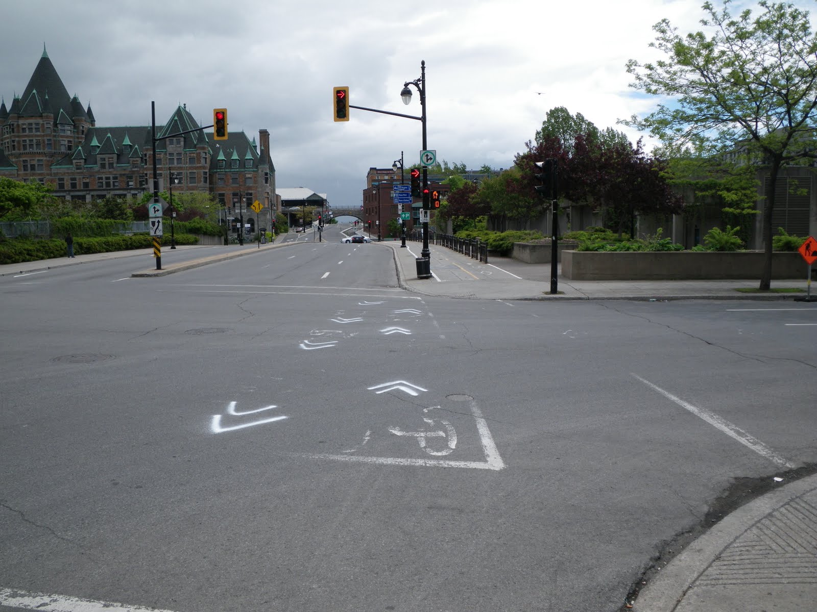 The closest we have to sidewalks that wide in Ottawa are along Wellington, which are well used by pedestrians, tourists, statues, and demonstrators. We do have a bike lane on a sidewalk, however--on the leadup to the Alexandra bridge around Major's Hill Park--and like this one it is annoying to go over the sidewalk ruts. A friend of mine crashed hen his wheel got stuck in the rut under the centreline on the Alexandra bridge sidewalk bike path.
Needless to say, a local cyclist we saw riding along this block had a much more comfortable time on the road than we did on the sidewalk!
Elsewhere downtown, there are on-street bike lanes like this one that seems to encourage cyclists to ride in the door zone (where a cyclist gets a "door prize" if a car door opens suddenly in front of them without enough time to stop or swerve). I'd be interested to see what happens when people are loading into or out of the car on the driver's side, or when motorists have to cross the bike lane to get into and out of the parallel parking.
 This lane on Saint-Urbain must also be relatively new, because you can see where the old lane markings were scraped off the street. While the lane appears to have been laid far enough from the curb to avoid the door zone, motorists park more lazily away from the curb, treating the bike like a buffer protecting their car from being hit by motorists.
Also note that parking is prohibited between 5 and 6 pm on weekdays, according to the sign at left. Does this mean that the curb lane is used for through traffic in rush hour? This would put motor traffic on both sides of cyclists, which mustn't be fun. That's an important thing to remember about bike lanes: the lane is in only one place, but the best place to ride your bike might differ depending on traffic and time of day/week/year.
 Montréal still has some room for improvement. These construction pylons are placed unceremoniously in the bike lane, and it doesn't look like provisions were made for cyclists (we were on foot at the time)
 Further out from downtown, some residential streets also had bidirectional segregated bike lanes, which are installed from April to November, like the many Bixi stations peppering the city. As with the Bérri lane, these are separated from cars by green posts, but a lane of parking was used as a buffer from moving traffic instead of a curb. Unfortunately, these lanes are also in the door zone.
 Riding down the street on a Saturday late afternoon, the street was deserted except for parked cars, and Meg and I instinctively rode down the centre of the street, as one would on MacLaren or Gilmour in Ottawa. It took us a block or two before we noticed that there was a bike lane on the other side of the parked cars. I wonder whether motorists are aware of the bike lanes when crossing them.
Here's how these lanes play out at intersections. A small, seasonal stop sign is required for the cyclists riding against the flow. Yellow sharrows are painted through the intersections, but these ones on Clark at Fairmount needed re-painting.
 It wasn't until I looked back at these photos that I realized that these streets weren't at all comparable to MacLaren and Gilmour. Just look at how wide they are! Take out the bike lanes and a one of thetwo rows of parking, and then you've got something approaching the width of Centretown's residential streets. Even Kent, MacLaren and Lyon aren't that wide. Laurier might be this wide, but it's two-way. There are few laneways, which isn't the case for most of Centretown's East-West streets. So you can't take Montréal's segregated bike lanes and plop them down in Ottawa.
But that doesn't mean there's nothing to learn from Montréal's on-road cycling infrastructure. For example, this anonymous one-way street crossing av. Laurier has sharrows going in the direction of traffic, with a painted contra-flow bike lane going in the opposite direction. (The view of the lane line is blocked by the cargo triker in this photo).
 I really like this facility, because it puts both directions of the cycling route on the same street, making directions much easier. In fact, I'd like to see this type of facility on Percy Street North of Flora (with parking moved to the West side), which would greatly help northbound cyclists coming from the Glebe who want to get to Chinatown without having to use Bronson, ride the wrong way on Percy, or jog a long block out of their way to Lyon. While the contra-flow lane is in the door zone in the above photo, you're facing traffic so passengers and oncoming cyclists can see each other--it wouldn't be an issue in Ottawa anyway, since we don't have enough room for parking on both sides.
As with the above intersection, sharrows connect the route through intersections. Interestingly, this street is one-way toward Saint-Joseph from both directions, so the contra-flow lane switches sides. A median prevents motorists from continuing through the intersection and going the wrong way, and the sharrows direct cyclists around it. Perhaps useful for Stewart at Waller?
 Even where there aren't bike lanes, sharrows are still used to denote cycling routes. For example, the sharrows in the photo below tell cyclists that the route continues straight. Where the route turned a corner, the sharrows indicated it (this is needed at the South end of Lyon's bike lane, where cyclists are supposed to turn right on to Arlington to get to Percy to cross under the Queensway. Councillor Holmes and I have been asking for sharrows and bike route signage at Lyon and Arlington, which will eventually come).
 Sharrows have the added benefit of reminding motorists that cyclists have a right to use the road, without constraining cyclists to a narrow lane that motorists expect cyclists to ride in--even if they're blocked by debris (glass/gravel), puddles, potholes, or parked cars.
Cycling advocates like bike lanes because they are a tangible reminder that says "you can cycle here", but as mentioned above, it's sometimes impossible to put down a bike lane because it has to be in the same place all day, but the best place to cycle isn't always the same during peak and off-peak hours. Sharrows prove a reasonable compromise that allows cyclists to ride on the part of the road/lane where they feel safest, but motorists still get that reminder.
Signs just aren't the same as they're often ignored or not recognized. Look at all the signs in this photo and tell me you'd notice, understand and follow them all while driving through this neighbourhood. The yellow sign at the right, for example, has a car and a bike on them, which I know means "[motorists] share the road [with cyclists]", because Ottawa has signs that show a motorist next to a cyclist and explicitly say "Share the Road / Partagez la route". If you zoom in, you'll notice that every other one replaces the car with an inline skate (definitely not a sign we use in Ottawa!)
 Stay tuned for part 3 of "What I learned in Montreal," where we go underground to see how the Métro stations function, and what this means for the proposed Downtown Ottawa Transit Tunnel. We'll come back to other cycling issues later in the series.
Edit: further reading on cycling route connectivity is available in the recently-posted Vélo Québec peer review (PDF) of Ottawa's segregated bike lane project. While much of the 23-page report is about segregated bike lanes, route connectivity is addressed as well.
Subscribe to:
Posts (Atom)