Showing posts with label Lisgar. Show all posts

Wednesday, May 7, 2014

Peds on Weds: Condo access fail

Suppose you're going to spend $18.5 million on a 12-storey (later 16-storey) condo building. You might build it with exclusively one-bedroom apartments that cater to young, single individuals. Such apartments aren't big enough to raise children, so you wouldn't need to worry about your residents getting in with a stroller. And your target market is decades away from using a wheelchair.

So despite legislation that gradually encourages more and more compliance to provide equal access to people with disabilities, you install a step at the front door:


If a resident loses a limb or is paid a visit by a wheelchair-using relative, there's a second-class entrance at the side of the building. When they're dropped off at the front of the building (as is customary), someone who is unable to walk up a step would of course have no difficulty walking 60 feet or so out of their way on a snowy sidewalk:


To add insult to (hopefully no) injury, the entrance was initially built with a direct ramp from the sidewalk. The step was added after the fact:


According to the Condo project website, a new development in "contemporary Canadian cities" has the following requirements: "a sharp and creative Development Team with a solid track record of success ... design innovation, marketing savvy, systematic project management, financial prowess and political acumen." (I won't go into the "partnership with...neighbours" bit where the first the community association heard of this development was the day before it went to the Committee of Adjustment)


But as the CCCA's Seniors Committee regularly writes in their column in the Centretown Buzz, our ageing population means that we also need to ensure that new buildings are built with accessibility and visitability in mind. These qualities are essential in ensuring that ageing individuals can continue to live in their homes, ensuring a healthy diversity of the community.

There's only so much you can do for older buildings that were constructed before universal accessibility was a consideration, but for new buildings there's no excuse a person with a mobility restriction can't enter the building with as much dignity as an able-bodied person from the first time they visit.

[Tune in on Wednesdays at noon for a new pedestrian-themed blog post. View the Pedestrians label for previous Peds on Weds posts]

Monday, April 28, 2014

Onramp houses on O'Connor

Christopher Ryan had a timely post on Ottawa Start about Connor Court, describing one of the low-rise apartment buildings built in the first half of the 20th Century. As he mentions, O'Connor Street is little more than an onramp to the 417 freeway all the way from the office buildings at the north end through the apartment/commercial district through Centretown.

South of a certain point, O'Connor is mostly mid-rise residential or low-rise commercial, there are a couple of exceptions. I noticed this house for the first time just earlier this month. It's 231 O'Connor, between Cooper and Somerset on the east side:


231 O'Connor is on the 1958 aerials on GeoOttawa, but it isn't on the 1902 (1912 revision) fire insurance maps (unsurprisingly, given the architecture). (Er, on closer look, it appears to also be commercial)

The same day I noticed the house above for the first time, I also took an appreciation for these two houses at numbers 312 and 314, on the west side of O'Connor just north of Frank Street:

Wednesday, February 5, 2014

Peds on Weds: Part 4: A history of sidewalk design in Ottawa

Today for the fourth and final entry of the sidewalk-design series, I'm going to give a history of sidewalk design, starting at the establishment of the original City of Ottawa, in 1855 (and earlier!). In part 2 of this series, I already gave a "little history" of the Toronto-style sidewalk design, relating specifically to how they became standard back to the establishment of the current amalgamated City of Ottawa in 2001. This followed part 1, in which I described "Toronto-style" sidewalks and the problems they're meant to address, and part 3, in which I discussed some of the issues the Toronto-style sidewalk itself has faced.

Today's entry starts with the West Ward Market, built in 1848 by Nicholas Sparks. This was used as Ottawa's first City Hall, roughly where the NAC is today.

r

The first municipally-built sidewalks in Ottawa actually predate the City of Ottawa's 1855 incorporation: by-law number 37 of the Town of Bytown, approved the 23rd of September, 1850, was "To authorize the expenditure of £75 in making a Plank Sidewalk, S. side York Street":

Wednesday, January 8, 2014

Peds on Weds: Toronto-style sidewalks part 1

For quite some time now, I've wanted to do a thorough writeup on what in Ottawa traffic-geek circles is referred to a "Toronto-style" sidewalk design. People love them and hate them, for reasons that I'll discuss over the next three weekly pedestrian-themed "Peds on Weds" posts, starting here.

The sidewalk seen below is an outstanding example of what people I know call a "Toronto-style sidewalk". I've no idea what people in Toronto call them, and for all I know the title might be apocryphal. The term refers to is a wide, flat surface for pedestrians, and the crosspath is ramped only to the minimum extent required for motor vehicles to get up to the height. This example is on the east side of Bronson looking north from Somerset to Cooper Street in August 2013, not long after it was installed. Pardon the spray paint markings:


The benefit is for pedestrians, but this is anathema to the car-centric roadbuilders who install them, as Eric Darwin described in a West Side Action post about the installation of the sidewalks on Bronson:
"I talked to the project / concrete foreman on the site [Bronson west side, north of Gladstone]. I complimented him on keeping so much of the walkway level. He, however, was much more interested in pointing out how gentle the motorists’ slopes were, so there wouldn’t be much of  bump for them."
The ramp is what gives the design its official name in the City of Ottawa, which has been the official standard in the City of Ottawa since June 2006: the "Ramp Style Vehicle Access Crossing" (being a traffic department term, naturally the title refers to its relationship to vehicles rather than to pedestrians or sidewalks). There is a gradual 2% grade over the flat part of the sidewalk to drain water away from the road (2% is not as steep as depicted here) which must be at least 1.05 m wide, and the ramp is 75 cm wide, assuming a curb height of 12.5 cm:

Thursday, November 7, 2013

3D Thursday: A tower comes down gently

When my hard drive crashed at the end of July, it took with it all the photos I had taken between May 30th to July 24th.

At Alex's suggestion, I had taken the drive to PC Perfect in the Glebe at the end of July. After a couple of weeks of no results, I gave up on it and moved on, but at the end of October I got a call saying that they'd been able to recover over 90% of the data! I've finally gotten it back and was able to reconstruct about 99% of the photos I'd lost.

While most of my photos were of long-term construction projects, I was particularly devastated by the loss of my photos from events like Bluesfest, Capital Vélo Fest and Doors Open Ottawa. But there was one group of construction photos that I couldn't reproduce, when Charlesfort was done with their tower crane on Lisgar:


Source photos for the 3D image: Left, Right

Most of the condo projects I've seen lately have taken their tower crane down all in one go on a Saturday, but this one, a climbing crane, un-climbed itself a couple days before the weekend. The result was a tower crane only about 7 floors up amid buildings two to three times its height.


Source photos for the 3D image: Left, Right

Considering we're used to seeing tower cranes high above their subjects, this was definitely a cool sight to be seen and captured!

(Another thing I had lost was the SVG graphic I started using as a watermark on my 3D photos. As you can see, I've got that back now too!)

[Tune in on Thursdays at noon for a new 3D image. View the 3D label for other posts with 3D images. 3D FAQ]

Monday, April 22, 2013

What's Happening in Centretown - April 2013 (CCCA)

Happy Earth Day, everyone!

Today's blog post is a message sent yesterday to the e-mail list of the Centretown Citizens Community Association by CCCA President Jordan Charbonneau. I've added the photos to this version.

I encourage all residents of Centretown to attend the Centretown Community Design Plan consultation meeting tomorrow night at 7pm at Dominion-Chalmers United Church. This will be an important opportunity for CCCA members and other Centretowners to learn more about the deal brokered by the CCCA and some members of the development industry. I should also note that I am on the Board of the CCCA. Of the 6 Board members who voted on this agreement on the second day of the February 2013 CCCA board meeting, I was one of the 4 who voted against (one of whom resigned after the motion was approved later by e-mail). I also remind readers, again in the interest of disclosure, that I work in the office of Councillor Diane Holmes, who has publicly objected to a number of provisions of the CCCA-developer agreement. Lots of information is in the April 2013 edition of the Centretown Buzz

Wednesday, June 27, 2012

Dominion-Chalmers in 3D

There's no Peds on Weds post today, as my list of pedestrian topics is full with complaints and problems, and I'd like to identify some more positive ones to balance it out.

Instead, I'd like to share another 3D image. I've refined my skills from the previous 3D image, showing a scene from the Bronson Avenue reconstruction, by taking better source photos and being more careful when processing them into something that looks good with red-blue glasses. This one's of the Dominion-Chalmers United Church on O'Connor Street between Cooper and Lisgar:

As with the previous 3D image I'm sharing the source images too. If you don't have 3D glasses you can theoretically "wiggle" quickly between these two images to approximate a 3D effect, though they would need some cropping before that would work well.

Unlike the previous one, I've made it full colour by retaining the green channel in this image (the two views were taken too far apart in the previous view, and when I tried to add the green channel it makes your eyes hurt to try to see the 3D). Since most of the 3D images I've seen growing up were red-and-blue line drawings, I didn't even know you could do this until I saw the instructions I followed. The way this still works, I suspect, is that one eye sees the blue and green channels, which are bold enough to tell your brain that this is what the object looks like, and the other eye sees the red channel, which the brain uses to add dimension to what it sees in the other eye. The three colours mix together as they would if they were all identical, creating the full colour. Photos with lots of bright primary colours don't do well with this because there isn't enough information for the two eyes to compare what they see.


Since I'm taking photos with a single camera, it's a bit harder for me to get the second shot to match the first (with two identical cameras you can simply take the photos from two different angles at the same time to capture live images). What I've found works reasonably well is to pay attention to the nearest object in the image (for the church photo, this would be the nearest corner of the garden curb) and where it is in the frame. Then pay attention to reference points on the four edges of the frame (For example making sure the door on the right isn't cut off and that the camera sees the far corner of the curb along the roadside at Cooper). There aren't many up/down cues to work with, which is evident from the discrepancy between the two shots, but it's not really a problem because I can just crop out the parts that don't overlap.

Another trick I learned is to look through the glasses the 'wrong' way when creating the 3D photo. My eyes don't see 3D images too well, so sometimes I'm unsure if I've successfully created the 3D image. If you accidentally filter out the colours in the reverse order, your brain can't simply compensate, but when you flip the glasses the image pops right out and the cursor floats above it. Unfortunately, in the GIMP, once you filter out the colour channels, you can't add them back in, so you have to start over if you make this mistake.

I've got other 3D photos in production for future blog posts, and I'm also looking into where you can get some cheap red-blue 3D glasses locally. I also have a second camera, which I might start carrying with me...

[Look for more one-photo posts under the label Singles]

Monday, February 13, 2012

Stairway to Centretown

Looking up the stairs to Queen Elizabeth Driveway from the Lisgar entrance to the Rideau Canal Skateway.


There's a new unofficial website for canal enthusiasts on the go. The page includes a colour-coded map of the ice conditions, in a format more suited to mobile phone browsers than the NCC's page: thebluefactor.com/canal. Winterlude wraps up on next week's long weekend, from Friday to Family Day on Monday. The canal is always open, weather permitting. So get out there and have some fun!

[Look for more one-photo posts under the label Singles]

Monday, December 26, 2011

Bert and Ernie go to Lisgar Collegiate

I bought this postcard at an antique show some years ago, a coloured print of Lisgar Collegiate Institute, the oldest school in Ottawa. While the date is hard to read, I think it says August 1918. Back then, the street continued straight past, and of course the 1960's south building hadn't been built yet.

This isn't an identical angle, but it's close enough to notice many changes to the roofline, not to mention the skyline behind it. Still, much of the building has survived well through many trials, including a fire in the 1890s and the major renovation in the 1970s.

But the kicker is the text of the postcard itself:
Dear Effie
[I] Was talking to Bert about Ernie & he says....
It was addressed to Mrs. E. S. Brown of Kirks Ferry, Quebec and stamped at a post office in Cascades, Quebec.

Friday, September 2, 2011

The Shape of Fog

Hey weather geeks! Remember when we had that stretch of rain in the middle of last winter? (I know, I wish I didn't either) It left us with lots of big puddles in the street, like this one in front of 307 Lisgar. I'm not usually so precise, but this photo was taken at 16:34

I mention the time because a mere 57 seconds later, a cloud of fog is pushing between the previously-visible Esplanade Laurier twin white towers. (I tweeted a similar photo taken from my Blackberry, though it's too old to show up in my Twitter photo archives.)

Normally when I think of fog in the city, it's just around. This image really shows that fog isn't necessarily shapeless.

And in case you're thinking I might have had a cloudy smudge on my lens, this one seals it, taken two and a half minutes on. The left tower now looks cloudy and the right one clear, suggesting the fog didn't expand much after passing through the gap between the buildings. In other words, whichever side I'm standing on, the nearer tower is clear and the further tower is obscured by the wall of fog. You can also (not) see the Mondrian at Bank and Laurier at the left.

It was quite serendipitous that I saw that house and decided to take a photo of it, because I obviously didn't realize the fog would roll in just a few seconds later. I was intrigued by the stark contrast of this little residential house sitting in the middle of parking lots, highrises and apartment buildings.

By the way... as I write up this post in early August, I don't know when I'll post it. Hopefully it's a hot day, and the reminder of the miserable winter helps you appreciate the heat.

Friday, July 30, 2010

CCCA Volunteers build new community garden

[Edit: See background information on this site at URBSite]

In the last couple of years, many people have observed that the grassed-over lot at the north-east corner of Lyon and Lisgar would make a good place for a community garden. I myself thought so when I was in the area taking photos for the post on 293 Lyon.

To my knowledge, the only other community gardens in the Centretown area are the Sweet Willow Organic Community Garden, the Nanny Goat Hill community garden near the Ottawa Tech High School field, one behind Umi Cafe, and the former BUGS garden at the CCOC's Beaver Barracks site, which is on hiatus during the construction of the new housing there.

The lot is owned by the Catholic school board, and is adjacent to the CCOC building at 455 Lisgar, where CBC Toronto lives (according to the text on this van, at least!).

The lot is fenced off with wooden posts, and an inner row of posts with chains. In between the rows of posts on the Lisgar side is a row of trees. Apparently it was a tough sell to the landowner to plant the trees, but they have taken nicely and are now bearing fruit.

In March, I noticed this ghostly face had been attached to one of the posts.

Since last year, the Centretown Citizens Community Association's Trees & Greenspace Committee has been working with the City of Ottawa, the Catholic School Board, the Just Food community garden network, and the CCOC to make this garden happen. The Committee's chair, Bonnie Mabee, deserves recognition for taking the lead on this, as does the CCOC's Meg McCallum. They worked out an arrangement among the School board, the City, the CCOC, and the garden, to get insurance coverage for the project, which was the biggest obstacle in getting the school board's permission to use the land. The CCOC will provide water to the garden.

This past Wednesday, Bonnie and her team delivered ground barrier material, and a big pile of sand was delivered today, which has already been partially spread around the site. For context, St. Patrick's church at Kent and Nepean is visible in the background of this shot, and the intersection of Lyon and Lisgar is just behind the camera:

The volunteers will be gathering bright and early tomorrow morning to assemble the boxes for the garden's 30 plots. Sorry--they're already all spoken for! Names were taken from the over 100 people on the waiting lists for the other area gardens.

A great congratulations and thanks are due to the many individuals and organizations responsible for making this new garden a reality. Good work, everyone!

Tuesday, July 20, 2010

Knox Church spruces up

Knox Presbyterian Church is a familiar site on Elgin Street at Lisgar. Anyone who attends Lisgar Collegiate or works at City Hall has probably walked past it hundreds of times on the way to Elgin. Here's the view from the kitty-corner:

As the Church's website explains, this is actually Ottawa's third Knox Church. The first one was in Sandy Hill. The second, opened in 1874, was on Elgin and Albert. This colourized postcard showing a photograph taken sometime between 1912 and 1915 from the old City Hall shows Knox Church in the foreground, with the still-extant First Baptist behind it on Elgin and Laurier, and Victoria Memorial Museum Building-with tower-in the background.

Monday, March 8, 2010

Images of Bronson

[Edit: visit RescueBronson.ca for information on the community-driven effort to get the City's engineers to redesign Bronson instead of lazily rebuilding it--with all its existing flaws]

Bronson Avenue is undergoing reconstruction beginning in 2011, all the way from Sparks to the Rideau Canal. It's being divided by the Queensway into two sections, each with its own Public Advisory Committee (PAC)--a group of business owners, community members, and other stakeholders. I'm the Centretown Citizens Community Association's representative on the section North of the Queensway. There are also representatives from the Dalhousie Community Association, the Centretown Citizens Ottawa Corporation, councillor Holmes' office, various condo boards, etc.

It will be the PAC's job to inform the consultant of what we'd like to see on the street in the redesign, and it will be the job of the Technical Advisory Committee to ensure our desires are met, and to work with the PAC to work out issues. I am similarly on the PAC (as the cycling representative) for the reconstruction of Somerset from Breezehill to Preston, and next year from Preston to Booth. I've found that to be a very fruitful process, with cooperative consultant who found ways to realize the goals of the community.

Not so much with Bronson. Their Technical Advisory Committee met twice and presented their results to Councillor Holmes, and the Public Advisory Committee hasn't even met yet! The consultant has actually tried to widen Bronson (presumably gaining space by shaving the bricks off the houses?), and has used a 1950's highway-expansion suburban model. Not a good sign so far. Councillor Holmes essentially told the City's engineers to start over, with more pedestrian-friendly engineers.

Anyway, I felt it was important that I familiarize myself better with Bronson, so on a nice day in early February, a friend and I took a walk down Bronson to take photos of the existing conditions. No doubt I'll take photos during and after construction as well.

I've tagged, geo-tagged, and uploaded the photos to a Picasa Web Album at http://picasaweb.google.com/centretown.ottawa/BronsonAvenue, and I've also uploaded them to Panoramio, which should eventually get them added as thumbnails on Google Maps. It was a very time-consuming process, but hopefully it will be useful during consultation.

Here are some highlights from the photos:

From the top. You can also see Bronson coming back up the hill at Laurier:


OMB supervillains on the Ottawa Tech wall:


Crosswalk/sidewalk near Bronson Centre. Note the precast concrete pavers in the crosswalk and the sidewalk. These should be replaced with something at least as good:


McPhail Memorial Baptist Church. You can see the recently-added elevator, built to match the existing style, as documented on West Side Action:


At Somerset. The on-street grates will be removed, a relief to cylcists. On the right you can see Peace Tower Church, formerly Erksine Presbyterian Church (also, wrongly, known as "Erskine"):


Nightmare sidewalk south of Somerset. A sidewalk snow plow requires 1.8m clearance to pass. Imagine trying to pass this sidewalk in a wheelchair!


I was admiring the decorative work above the side door of this house when my friend pointed out the strangely-placed window--in the chimney!


While the front door did not survive the fire at 346 Bronson, the stained-glass windows next to and above the front door did survive. Dr Tung Le has relocated a few blocks East, to O'Connor. (The above-door window and the sign with relocation details are in the album...click the photo)


My friend also pointed out that Gail's Hair Design is just the front of a building, and that there was a house buried inside there somewhere, which you can just make out here. Auntie Loo's is just a couple houses down.


Lastly, since we're ostensibly concerned with the street, the crosswalk at Catherine. I was rather surprised by the backup of traffic on Bronson all the way back up from, presumably, Carling.


A good chunk of the way through, maybe around Gladstone, it became really tiresome to continue taking photos. Partly because I hadn't brought warm enough gloves, but mainly because Bronson Avenue is so incredibly hostile to pedestrians, with largely uninteresting buildings, narrow sidewalks, and high traffic on many lanes. We made a point of using a side street to get back up to Somerset.

Hopefully the City will actually listen to the input of the community so that Bronson can be less depressing and difficult to traverse by foot, bicycle, and wheelchair.

Don't forget to have a look at the Picasa Web Album photos: http://picasaweb.google.com/centretown.ottawa/BronsonAvenue

There are some really nice photos in there!

Thursday, February 25, 2010

Stone's throw

I noticed this view in early February, which shows three stone buildings on Elgin Street: the former Normal School (Teacher's College) that is now the Heritage Building wing of City Hall, Knox Church at Lisgar, and the stone house (now rental apartments) behind the stores on Elgin at Cooper, the name of which escapes me.

The Fairmont Château Laurier is also in the background of the photo.

[Look for more one-photo posts under the label Singles]

Wednesday, February 24, 2010

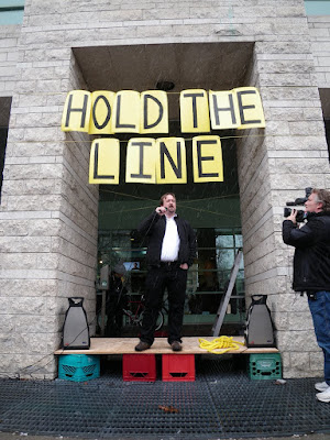
Photos: Hold the line rally reprise

The group Our Ottawa organized a rally today to oppose expansion of the urban boundary. More details in this Citizen article.

Among the speakers, Ecology Ottawa's Graham Saul made an excellent and impassioned speech:

The crowds were not too bad for a snowy Wednesday noon in February:

More photos here: http://picasaweb.google.com/ centretown.ottawa/HoldTheLineRepriseRally20100224

...also, if this rally sounds familiar, it's because Council already decided this issue back in June. There was even a rally, on May 12th:

A number of councillors were at last year's rally, and many of them spoke. Councillors Cullen and Jellett were both in the crowd at the rally today.

Photos from that rally are at http://picasaweb.google.com/centretown.ottawa/ HoldTheLineRallyForASustainableOttawaOnUrbanSprawl

Monday, February 8, 2010

Monday & Tuesday: Charlesfort 20-storey Lisgar tower proposal

Charlesfort Developments is going to the Committee of Adjustment on February 17th, 2010, to seek 'minor variances' for a 20-storey residential tower across from City Hall.

Doug Casey, President of Charlesfort, wants to speak to the CCCA at tonight's meeting of the CCCA's Planning & Development Review Committee (5:30pm at Second Cup on Elgin and Lisgar). There will also be a broader community consultation tomorrow (Tuesday, February 9, 2010) at 5:30 p.m. in the Billings Room at City Hall.

As shown in the diagram below, the proposed building is nearly 2/3 heigher than the maximum allowed 37.0 metres. Casey says that the total floorspace approximates that of a big box that fills the entire permitted building envelope, citing the many such boxes in the neighbourhood. But that's just the theoretical box if you build to the maximum dimensions--one is not obliged to build to the maximum, and one is not entitled to exceed one limit merely for staying within another.

As for the site, it's the parking lots at the corner of Lisgar and Cartier, directly across from City Hall and the Heritage Building of City Hall. There's a two-storey red brick house (now serving as offices) next door.

The submission also says that the stepped nature of the building helps to break up its massing. This it does, to an extent, but it does so by reducing the minimum east and west side lot setbacks from 1.5m to zero for the first 13 metres of the site, and by reducing the rear (southerly) setback to 3.5 metres. The red brick house next door will be dwarfed.

The flatness of the front of the building is also evident in the elevation diagram:

I set up some diagrams of my own, based on how the surrounding context would look with this building nearby. The scale is approximate.

Here, for example, is a photo I took this summer of the trees in the island in front of City Hall's Lisgar street entrance. The lot in question is behind it

And here's how it would look (approximately) with the proposed Charlesfort building:

As for the height, I tried to approximate how it would fit into this scene taken from Albert Street. I think the building would actually be a bit taller than how I set it up here, but even so it's clearly taller than anything else in the Golden Triangle.

There are a few opportunities to learn more and get involved:

  • Tonight: CCCA Planning & Development Review Committee meeting, 5:30 p.m., Second Cup, Elgin & Lisgar

  • Tomorrow, Tuesday, February 9: Community meeting to present/discuss the proposal (organized by Coun. Holmes and Charlesfort). 5:30 p.m. at City Hall (Billings Room - second floor)

  • Now to February 16th: Send your comments to the Committee of Adjustment (cofa@ottawa.ca), to Councillor Holmes (diane.holmes@ottawa.ca), and to the CCCA

  • February 17th: Make a presentation at the Committee of Adjustment's Public Hearings at Ben Franklin Place Client Service Centre, 101 Centrepoint Drive.