Showing posts with label NCC. Show all posts

Saturday, January 4, 2025

Wellington Street Part 12: 50 Years of Rapid Transit in Ottawa

Part 12: 50 Years of Rapid Transit in Ottawa

   [Show/Hide Contents]

I wanted to pick up the narrative of Wellington Street to line up with an important milestone in Ottawa transit history: the 50th anniversary of bus lanes in Ottawa. It doesn't involve much in the way of the theme of this blog series—the connections, disconnections, and renamings of Wellington Street—but there is a dash of that. Alas, I missed the 50th anniversary for this blog post (by over a year!) but I did get a September 2023 article on the topic published in the Centretown BUZZ newspaper.

In the previous post in the series, we left off with the 1974 opening of the Portage Bridge, connecting the west end of Wellington Street, at the Ottawa River Parkway, to Hull, and severing Wellington Street from itself in LeBreton Flats. Today, we'll rewind a couple of years to look at how rapid transit in Ottawa began to reshape traffic patterns on the various Wellington Streets, such as here on the Ottawa River Parkway:1

1974 photo of two lanes of cars curving toward the camera in a landscaped area, and two buses in the distance on a separate pair of lanes (i.e. the Ottawa River Parkway).

Friday, May 5, 2023

Wellington Street Part 11: The Portage Bridge

Part 11: Portage Bridge

   [Show/Hide Contents]

The Jane's Walks Ottawa walking tour festival takes place this weekend, with a launch event picnic dinner under the Booth Street bridge at Pimisi Station today from 6-8pm. This year's festival theme is Building Bridges, which fits in very well with the next section of my blog series on the many traces of Wellington Street: The Portage Bridge.

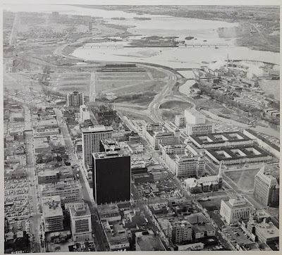
In the previous post, Part 10, we took a step back into the NCC's rearrangement of land and roads in LeBreton Flats in the 1960s. This resulted in the splitting of Wellington Street ending just west of Bay Street as it turns into the Ottawa River Parkway, and connecting to itself via offramps, as we can see here in this photo:1

Aerial view from above looking west in 1967. Centretown/Uppertown in the foreground including Place De Ville and Library and Archives Canada; LeBreton Flats in the midground; Ottawa River, Lemieux Island and Mechanicsville in the distance. Chaudière Island industry at work. West of Bay, Wellington Street becomes the Ottawa River Parkway with an offramp connection to Wellington Street through LeBreton Flats.

That arrangement would be relatively short-lived.

Thursday, December 29, 2022

Wellington Street Part 10: Nepean Bay and the Ottawa River Parkway

Part 10: Nepean Bay and the Ottawa River Parkway

   [Show/Hide Contents]

In the previous post, we talked about the peripheral effects on Wellington street from the Garden of the Provinces construction, the LeBreton Flats expropriations, and the lowering of the C.P.R. Prescott Subdivision (all NCC projects).

Today's post will look at the Ottawa River Parkway, whose history is not well documented insofar as it affects Wellington Street. We're still in the 1960s, prior to the breakup of Wellington at the viaduct covered in part 8.

To get us situated, this colour photo from the early 1960s shows Wellington Street winding up from the bottom of the photo up across the viaduct, through LeBreton Flats, and into downtown:1

Colour aerial photo of LeBreton Flats, Bayview, and Nepean Bay before removal of railroad infrastructure and before expropriation of LeBreton Flats. Wellington Street viaduct, O'Keefe brewery, railyards tracks roundhouse, Chaudière Victoria Albert islands, Ottawa River. Somerset viaduct.

Monday, January 24, 2022

Wellington Street Part 9: The NCC's distractions (early-mid 1960s)

Part 9: The NCC's distractions (early-mid 1960s)

   [Show/Hide Contents]

In the previous part of this series about the renamings, connections, and disconnections of Wellington Street, we looked at the Ottawa Journal campaign leading up to the August 1969 viaduct transplant that broke Wellington Street apart over the tracks to connect with Scott. Today we'll skip back a few years now to look at what the NCC was up to around Wellington Street in the early 1960s.

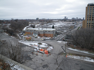
December 2012. Looking from the park atop the cliff at Bronson and Sparks down to LeBreton Flats including old Wellington Street, Pooley's Bridge, and Fleet street. Water pumping station is undergoing repairs. Condos south of Fleet not yet started construction. Transitway, no Booth Street bridge yet. A light dusting of snow.

Sunday, April 25, 2021

Wellington Street Part 6: Postwar traffic on Wellington

Part 6: Postwar traffic on Wellington

   [Show/Hide Contents]

Back in January 2020, we left off with Part 5, in which we watched traffic get heavier on Wellington Street from the 1910s to the 1940s. After a hiatus to do more research and life getting in the way, we're now back to look at government interventions in and around Wellington Street in the ten years following the end of World War II.

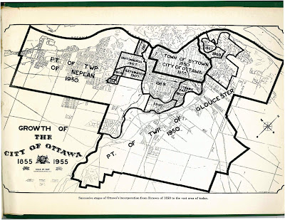
The biggest change for the City of Ottawa was on January 1, 1950,1 when Ottawa annexed nearly all nearby developed area, including Westboro, Ottawa West, Hampton Park, Highland Park, Woodroffe, Laurentian View, McKellar, Britannia, etc. Thich comprised 7,420 acres (3,000 hectares or 30 square kilometres) of Nepean and Gloucester Townships,2 as seen in the two large sections on the map below.3 Much of this was burgeoning suburban development which fed a daily stream of workers into downtown Ottawa.

Map of City of Ottawa from 1955 showing annexations/expansions up to that point, starting with Town of Bytown 1850 City of Ottawa 1855 in the middle and the largest expansions reading Pt of Twp of Nepean 1950 and Pt of Twp of Gloucester 1950.

Although Richmond Road was thus brought into the City limits, it retained its name west of Western Avenue, where Wellington ends.4 Since there were no major physical changes to Wellington Street specifically in this period, today's post will look at traffic in general on Ottawa's Wellington Street.

Wednesday, January 1, 2020

The many traces of Wellington Street - Introduction

You may already know that Ottawa has both a Wellington Street and a Wellington Street West, but it was not always so simple. A man standing at the corner of Scott and Bayview in the pre-smartphone days of the early 2000s asked me for help finding an address on Wellington Street, and I had to confess that I didn't know which of three Wellington Streets to direct him to!


I was reminded of this recently and got curious about when these various geometric and name changes took place. I already knew that the City of Ottawa renamed many streets, including two of the Wellingtons, following amalgamation in 2001, and a quick look at an aerial photo reveals clues to how various physical changes broke Wellington Street up. Dennis Van Staalduinen tried his best to explain it on a couple of Jane's Walks in 2012 and 2013, the notes of which he has posted on his website, and a follow-up map in 2016. I even covered the topic myself in a 2010 blog post!

Photo of a green highway-style sign reading Wellington East and pointing to the right

But these were all snapshots; I wanted the whole story. I searched my own collection of books on LeBreton Flats, Ottawa, and the NCC, and found nothing describing the actual changes to Wellington Street. I searched the Web as well, but found only the most recent changes. It turns out that anybody who's written about LeBreton Flats has been more interested in the buildings, people, and land, than on the nomenclature and alignment of its primary artery! (I jest; this is entirely reasonable)

So I took a few trips to the Ottawa Room, bought a subscription to Newspapers.com, and collected a trove of information about Wellington Street, with many twists and turns along the way. Changing names and alignments is a Wellington Street tradition that goes back to the early 1800s and most recently this past September!

Over the past two months, I've painstakingly assembled this information into the following blog series to detail everything I can find out about Wellington Street—everything, that is, except for the buildings, people, and land! Depending on how you count it, Wellington Street was officially renamed between 7 and 21 times, and that doesn't even count all the times where it got physically disconnected or redirected! I've done my best to filter out the wrong information and provide sources for the rest; corrections are welcome by email, tweet, or comment (all comments are moderated).

The first part goes up tomorrow at noon, and the rest of the 10+ parts are in various stages of development and will be posted thereafter. The posts and the headings within them will be added to the bottom of this post as they are added. But first, a quick rundown of Wellington Street:

Monday, February 19, 2018

That time I was on the Skate Patrol for ten years (Family Day finale)

Today is Family Day and the last day of Winterlude, which makes for a good place to finish my series about my time as a member of the Rideau Canal Skate Patrol. You may want to first read part 1 and part 2.

Starting in 2011, the NCC wanted a skate patroller to be up on the ground level for the annual flag-raising ceremony which marks the official opening of the canal, and I was that skate patroller. I wasn't in the scrum during the actual flag-raising, instead I stepped back to take a video of the flag raising. I believe this one was take 2, because some of the media photographers missed the flag going up the pole the first time:


I then posed for some photos, including this one with an Ice Hog mascot (think groundhog, but with ice) and someone who was introduced to me as a dignitary from the insurance company that sponsored the skate patrol that year:

Sunday, February 4, 2018

That time I was on the Skate Patrol for ten years (Part 2)

In Part 1 of this three-part series, I explained how I got my start on the Rideau Canal Skate Patrol. I left off in 2009, the year after we got new neon yellowish-green jackets. Here I am in said jacket at my favourite Ottawa footbridge:


2009 was a year with many changes, and not just the Obama bandwagon that Beavertails jumped on:

Saturday, February 3, 2018

That time I was on the Skate Patrol for ten years (Part 1)

The 40th edition of Ottawa's Winterlude festival has opened this weekend, and its crown jewel, the Rideau Canal Skateway, is enjoying a good season. This year has had the earliest start in four years, after a record short 18 skating days in 2016 and 25 skating days in 2017.

The official @NCC_Skateway Twitter account often posts tidbits about the skateway, for example, a tweet mentioning that there is a team of 60 skate patrollers on the canal.

As it happens, I served on the Rideau Canal Skate Patrol for ten years, and I've been meaning to write about it. Now that I've been off the patrol for a while, it's time for me to come out of the shadows...

Thursday, February 13, 2014

3D Thursday: Bicycles and icicles

This past weekend, Citizens for Safe Cycling's third annual Family Winter Bike Parade ended at 8 Locks' Flat, where a number of bike racks were laid out for us on the patio, which we diligently filled. A number of cyclists had already left by the time I took this photo:

Source photos for the 3D image: Left, Right

Mike from the Ottawa Bicycle Lanes Project posted a Vimeo video of the ride.

As I left 8 Locks' Flat, I noticed some people had hung some posters from the Corktown Footbridge. If you zoom in, you can make out the words "Marry Me Tia". Awww... (I didn't get a 3D photo of it)


I then headed to the Winterlude festivities in Confederation Park to check out the ice sculptures. As with previous years, there were plenty of military themes, in particular commemoration the start of World War I. This life-sized sculpture depicts women waving off their soldier husbands or boyfriends heading off to war by train.

Source photos for the 3D image: Left, Right

Another angle:

Source photos for the 3D image: Left, Right

Here's the official description of the sculpture, entitled "100 Years Later – The Beginning of the First World War"


This sculpture is presented by Veterans Affairs Canada, and Winterlude is for the first year being presented by the department of Canadian Heritage, as indicated by the banner at the bottom of the placard. (The NCC still maintains the Rideau Canal Skateway.)

The 36th edition of the three-weekend-long Winterlude festival continues in its final weekend this Saturday through Monday (Family Day) along the Rideau Canal, in Jacques Cartier Park, and at various venues elsewhere.

The skateway will remain open after Winterlude for as long as conditions permit. See current conditions on the official NCC Ice Conditions website or on this unofficial website which is more mobile-friendly.

[Tune in on Thursdays at noon for a new 3D image. View the 3D label for other posts with 3D images. 3D FAQ]

Monday, April 15, 2013

Bixi's back for 2013

As of today, Capital Bixi is back in action! For subscribers like me, that means my key should work for the remainder of my one-year subscription (which I bought last June). And for you readers of my blog, that means I'm going to blog about it!


I never got around to blogging my Bixi photos last year (and the year before, my season-opener blog post used photos from the 2009 pilot), so I get to include some of those with this post. For example, the one above was taken last June at the Museum of Nature's east lawn, at Elgin and McLeod. On Saturday night, the bikes had been re-installed, though it was decidedly snowier:

Wednesday, February 27, 2013

Peds on Weds: Pathway plows along the canal

Since the canal is not yet officially closed for the season (though it's "Temporarily" closed as of this morning), I figure a post about walking conditions along the canal is timely.

While the NCC doesn't plow any of its pathways*, the City does. And I don't just mean that the City clears snow from City pathways—the City also plows the NCC's pathways along the canal, both on the Queen Elizabeth Driveway and Colonel By Driveway sides. The plows used aren't necessarily the same as what we're used to seeing on sidewalks, though. Here is the Argyle entrance to the canal in the south end of the Golden Triangle, and a plow is going by:


Zooming in, perhaps you can see the trailer being pulled behind the vehicle?

Wednesday, July 11, 2012

Seeing green (#ottbike box Bay/Wellington)

Sorry for the lack of blog posts; I've been spending all my time and energy on the Bluesfest bike parking, which is Citizens for Safe Cycling's biggest fundraiser of the year. (By the way, we have not filled up yet, and the 'lineups' at the end of the night are rare, five minutes tops, so ride your bike and leave it securely with us!)

On my way back last night from the Blesfest office at 2:30am, I saw the City crews installing the thermoplastic green coating for the bike box at Bay and Wellington. This helps cyclists turn left, and avoids cyclists getting the 'right hook' from right-turning motorists. The thick plastic surface—the same stuff used in the intersections along the Laurier bike lanes—is melted on with torches and is pretty resilient. You can seee the workers melting on the final touches at the far end of the lane here, just in time for the one-year anniversary of the Laurier Segregated Bicycle Lane!

I chatted with the guy who was responsible for finalizing the design of the bike box. He also worked on the Laurier bike lanes and is working on the lane configuration for Rideau Street.

The bike box is to connect to the new segregated bicycle lane along Wellington street, which in turn connets to the pre-existing segregated bike lane on the NCC's Portage Bridge.

That whole intersection was completely redone in the last couple of months, adding crosswalks and bike lanes to the previously pedestrian-free intersection (pedestrians and bikes were expected to navigate a confusing route of paths and tunnels under the various corners of Wellington Street).

When you get to the Wellington/Portage intersection westbound, there's another new road device: since cyclists coming from Hull/Gatineau off the Portage bridge are on the wrong side of the street, they'll have to get to the south side of Wellington. This little drop-off area lets them pull away from the northbound cyclists and dismount to cross the intersection. Northbound cyclists (in the direction from which this photo was taken) can also dismount:

Dismounting is required because the Ontario Highway Traffic Act (rightly) prohibits cycling in the crosswalk. The City's cycling department wanted to install a "cross-ride" here—essentially a channel alongside the crosswalk in which you can cycle—but since the provincial law doesn't have provisions for such a facility, they couldn't. (psst: Ottawa—Centre's MPP is Yasir Naqvi, I'm sure he'll love to hear from you!)

Until it is, you'll have to get off your bike and walk. The paths and tunnels that weave under the intersection are unchanged, and still very much useable if you'd rather stay out of the intersection.

The next "missing link" in the cycling network on the City's list is the jog in the east-west Byron-Gladstone cycling route at Tyndall between Parkdale and Holland. Not in Centretown, or even in Somerset ward, but you're probably interested nonetheless.

Alright, back to Bluesfest for me! Once the festival's over, I'll have to get back through my considerable backlog in sorting my photos! Blogging will continue to be sporadic until the end of the month.

Wednesday, May 2, 2012

Peds on Weds: Steps in a pond

While looking for a vantage point recently to check out the work on the Portage/Wellington intersection roadwork (they're adding crosswalks), I stumbled upon this pond in the Garden of the Provinces and Territories, a park nestled between Lebreton Flats, the Parliamentary Precinct, Centretown, Dalhousie, and Cathdral Hill. The park has won a few awards, though I've never seen it with many visitors.

What struck me about this pond (I assume it's a pond in the summertime) is the little steps on the left. Presumably, this is a little walkway across the pond.

I had seen a similar formation in a park last summer when traveling in Ankara, Turkey. It pushed the concept further: it was a path that actually led someplace, and if you for whatever reason had to go around, it was a significant trip. Being built on a moutain/valley, Ankara has many steps and isn't very accessible to begin with (though they are making progress). But accessibility wasn't in my mind at the point so much as the thought that you'd never see such a thing in Ottawa, right? (click to enlarge)

Well, evidently you can. And while it doesn't quite pull off the look of the Myst computer games (despite being devoid of other people), it does look nice and has weathered well. I look forward to seeing it in the summer when the water is turned on!

For this week's Peds on Weds content, check out How Walkable is Ottawa? on Apt613, which has many links to pedestrian-related news and resources. Also make sure to check out JanesWalkOttawa.ca for a Jane's Walk this weekend near you.

Monday, February 13, 2012

Stairway to Centretown

Looking up the stairs to Queen Elizabeth Driveway from the Lisgar entrance to the Rideau Canal Skateway.


There's a new unofficial website for canal enthusiasts on the go. The page includes a colour-coded map of the ice conditions, in a format more suited to mobile phone browsers than the NCC's page: thebluefactor.com/canal. Winterlude wraps up on next week's long weekend, from Friday to Family Day on Monday. The canal is always open, weather permitting. So get out there and have some fun!

[Look for more one-photo posts under the label Singles]

Monday, January 30, 2012

Thunder and snow

Just over a decade ago, the National Aboriginal Veterans Monument was unveiled at Confederation Park, across from the Lord Elgin Hotel on Elgin Street. After a recent storm, snow covered the wings of the golden eagle, (representing the mythical Thunderbird).

I remember watching the monument being installed. For a number of months before the opening, the big square rock on which the statue is mounted sat on its own. Finally, a statue appeared and it made a lot more sense.

Snow also means winter, which in Ottawa means Winterlude. Confederation Park is one of the primary sites for Winterlude, and the Lord Elgin already has its banner up promoting the event. There's also a trailer for a vendor to set up a waffle tent during Winterlude. The timing couldn't be better, as local blog Apartment613 has been fuelling interest in local waffles.

[Look for more one-photo posts under the label Singles]

Monday, January 16, 2012

Rideau Canal Skateway now open for the 2012 season!

The Rideau Canal skateway opened at 10am on Sunday morning, with the NCC announcing it just an hour before. The rest area at Fifth Avenue/Holmwood is picture-perfect, with a fresh layer of snow on the evergreens. The ice is so glassy smooth that you can see the canal amenities reflected in it!

Of course, no NCC event would be complete without a hokey media event. Two of the official Winterlude mascots, the Ice Hogs, were out on the ice behind the speaker at the podium (as captured hugging adorably in a photo by CBC reporter Alistair Steele via Twitter). One of them climbed the stairs to raise the green flag, making the opening official. (Unfortunately my photo is from a bad angle to see the flag, again, but Steele got a good photo of that, too)

Wednesday, December 21, 2011

The miniature street sweeper

Back in October when the Occupy Ottawa protest was still well-established in Confederation Park, I went by a couple of times to see what there was to see. Someone with a generator, bucket, and various tools was at the NCC's miniature bronze map of downtown Ottawa-Gatineau. The more tourist-oriented streets appear to be brass, and this person was cleaning them with a Dremel and various abrasive sponges.

I didn't realize she wasn't with the protesters, as a gasoline generator and water jugs was the kind of thing the protesters would have with them. But it turns out she works for the firm of the original artist, which was hired by the NCC to do some cleaning and updating some features on the map (like adding the new Convention Centre and removing the Capital Infocentre).

I chatted with her briefly, but unfortunately it's been too long for me to remember any noteworthy details.

Click on the photos to view full-size. I think it's a neat throwback to the scale models used by Jacques Gréber to illustrate his plans for the capital (Such as #151 and others listed here)

Wednesday, July 27, 2011

Bixiiiii

This photo is from back in April, on the bidirectional pathway along Mackenzie Avenue toward the Alexandra Bridge. I took it on my foray up to Nepean Point. This was very shortly after the launch of the Capital Bixi program: I saw five people on Bixis coming along, and managed to catch them all in the same shot on my first (and only) try:

Parliament Hill is in the background, but I had neglected to consider its appearance in the photo.

[Look for more one-photo posts under the label Singles]

Monday, July 25, 2011

Follow the yellow line

Sorry for the absence. I was busy running the bicycle parking at Bluesfest 2011, which is a 100-hour-a-week volunteer gig. You'll be happy to hear that I've got over two weeks of posts pre-scheduled, so there won't be another gap for at least as long!

Most of the time, when a pathway in the national capital region splits, the yellow line will follow the direction where the pathway continues in whatever direction. For example, if you're trying to navigate the pathways under the Portage Bridge to get westward from behind the Parliament buildings, following the yellow line will help you get back to the pathway along the Ottawa River.

Many cyclists don't realize this, but they do get it at an unconscious level. Take here for example:

This is just under the Laurier bridge heading North toward the convention centre and Byward Market, on the pathway that runs along Colonel By Drive. This is a notoriously difficult place to navigate because it's not clear at all how to get from here to the other side of Rideau/Sussex.

Unfortunately, when I stopped to watch for a bit, I saw most cyclists followed the yellow line up to the abutment of the Laurier Bridge, which led them to a dead end and a hard curb along Colonel By Drive. They, as I had done just before them, ended up going down the steep cobbled footings of the bridge to get back to the pathway along the Rideau Canal and continue toward Union Station.

Unfortunately, even if this line gets fixed (which it might, there was still some construction going on when I took this photo in May 2011), there's not much place for people to go once they pass the bridge, it's still every cyclist to him- or herself to navigate Colonel By, Sussex, and the rest.

[Look for more one-photo posts under the label Singles]