Part 11: Portage Bridge
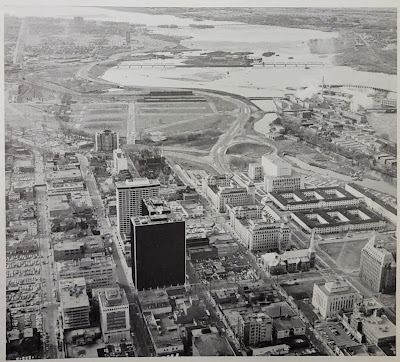
The Jane's Walks Ottawa walking tour festival takes place this weekend, with a launch event picnic dinner under the Booth Street bridge at Pimisi Station today from 6-8pm. This year's festival theme is Building Bridges, which fits in very well with the next section of my blog series on the many traces of Wellington Street: The Portage Bridge.In the previous post, Part 10, we took a step back into the NCC's rearrangement of land and roads in LeBreton Flats in the 1960s. This resulted in the splitting of Wellington Street ending just west of Bay Street as it turns into the Ottawa River Parkway, and connecting to itself via offramps, as we can see here in this photo:1
That arrangement would be relatively short-lived.
Options for crossing the Ottawa River
While there had been plans to extend the Parkway through downtown, "creating a future driveway from Government House via Sussex Drive, past Parliament Hill, and along the river to Britannia,"2 NCC Chair Douglas Fullerton, newly appointed in September 1969, "practically brought the parkways program to an abrupt halt." He had other plans, including bicycle paths, garden plots, and skating on the Rideau Canal.3
A new road bridge across the Ottawa River, connecting the downtowns of Ottawa and Hull, was proposed as far back as the 1915 Holt Commission plan:
Jacques Gréber's 1949 Capital Plan had a different take, proposing "reconstruction, in two stages, of the Chaudière Bridges from Wellington Street at the westerly end of Parliament Hill, to Eddy Park in Hull [and] Gradual park treatment of the Chaudière islands, peninsula and Ottawa River banks,"4 with an underlying goal of "the restoration of the Chaudiere Islands to their primitive beauty and wildness."5
This reconstruction would take the form of "a wide and graceful viaduct ... across the Ottawa river by way of the Chaudière islands. Its approach will be a graceful arc swinging riverward from Wellington Street just west of Bay Street,"6 as shown here:7
By November 1952, "plans for the new structure have already been drafted and have been submitted to E. P. Murphy, deputy minister of Public Works, and departmental engineers for approval," and the 4,000-foot (1.2 km) long bridge was expected to begin construction within two years. "The old Chaudiere Bridge would continue to be used to serve traffic to Middle Island and the E. B. Eddy and J. R. Booth Paper Mills."8 As you might have guessed, this plan was never carried out, but it continued to be shown on the Federal District Commission's Ottawa-Hull tourist map in 1958:9
The 1955 traffic study discussed in Part 7 also came to the conclusion that "existing bridges are inadequate for present traffic requirements," i.e. 38,000 daily Ottawa River crossings, expected to increase to 52,000 by 1965.10 The report proposed four new interprovincial bridges, the central-west of which to be not at Chaudière Falls but at Chaudière Rapids (along the west edge of Lemieux Island to St. Joseph Blvd.), "constructed concurrently with the section of north-south expressway [i.e. the Champagne expressway] which will connect the Chaudiere Rapids Bridge with the Queen's Way... Although not warranted by present traffic volumes and travel desires, it is expected that the future development of the area and the resultant traffic growth will be such that these bridges will be required by 1975."11
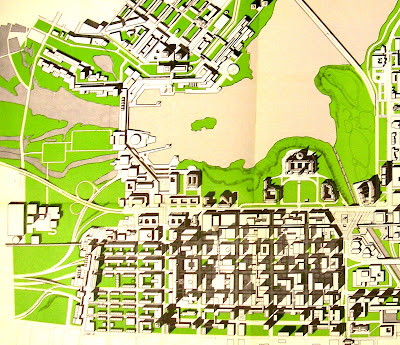
The 1969 Central Area Study, prepared by Philip Hammer for the City of Ottawa, NCC, and Ontario Department of Highways, envisioned a "Mini-Transport" incorporated in the mega office building complex that would span the River here, as part of its proposal to isolate pedestrians from motor vehicles.12
Despite the Hammer report's "misleadingly optimistic" population growth projection of 3.5 per cent compounded, "it was quite clear by 1967 that the great federal building boom [in Ottawa] was over," and an NCC study released in January 1970 instead forecast a growth rate of only 1.6 per cent.13
Bridge name, location decided
Of all these schemes, the oldest was closest to what they went ahead with. On 1970-02-26, Public Works Minister Arthur Laing and Regional Economic Expansion Minister Jean Marchand (no relation) announced a new NCC project that would further alter the course of Wellington Street: a $10,000,000 six-lane bridge between Ottawa and Hull crossing Victoria Island, with construction to start in the summer.
The bridge and its approaches would be funded fully by the NCC in order to avoid delays in negotiating with other levels of government, and so the bridge would be ready by the time the Place due Portage Phase 1 development was complete 20 months later.14,15 "The Department of Public Works is responsible for the design and construction of the bridge,"16 and "the National Capital Commission is responsible for the financing of the link system, its planning and urban character as well as the landscaping of the project."17 "Plans and specifications for the new Victoria Island bridge were drawn four years ago, disclosed Mr. Laing, and currently are being up-dated to cope with the vastly increased traffic demand" from the Place du Portage development.15
Of particular interest to Wellington Street, "congestion of Wellington Street West and the access to both the Ottawa River Parkway and the loop through LeBreton Flats to the Chaudiere Bridge will be circumvented by overpasses."15
On 1970-04-24, the bridge was announced again, this time with a tentative name: the "Portage Bridge". "We expect to have soil surveying underway within a few days and workmen may be on the site next week" said an aide to Marchand.18 The bit about avoiding negotiations with other levels of government may have been taken a bit too enthusiastically: Disgruntled City and Regional Municipality officials had to learn about the bridge from news reports!19 The City and RMOC would be responsible for changing the streets around the Ottawa side of the bridge,17 which they hadn't accounted for in their budgets.20,21 All parties, including the province,22 assumed that a connection from Bronson to Wellington would be required.
Ottawa Mayor Kenneth Fogarty alternately denied opposing23 and supporting24 the bridge, before eventually concluding that "We have no better location in mind" and "problems could be mutually worked out as they arise."25
In November, 1970, Laing blamed the NCC for delays, saying that if they could finalize talks with the City of Ottawa and Province of Ontario, "we could start building almost immediately, plans and specifications are that well in hand."26
Construction begins
The first of five contracts for the bridge and its abutments was tendered in August 197127 and contracted in October to C. A. Pitts Engineering Construction Limited of Toronto.28 That month, as rapid transit began to germinate as a topic of discussion in Ottawa (coming up in Part 12), Peter Korwin, head of the NCC's Quebec planning division, claimed optimistically that the bridge would be six lanes wide in order to accommodate two of them for buses.29
Contract awards for the subsequent phases, with the plans prepared by engineering consultants Demers-Parker Ltd. of Ottawa,30 were announced on 1971-11-19 to Pitts,30 on 1971-12-29 to Dominion Bridge Company Limited for the superstructure and road approaches,31 and 1972-05-03 to Dibblee Construction Co.32 for a substantial portion of the work including abutments, roadway, and other details like handrails and the parking garage for the Mill restaurant, with work "to be completed by Dec. 30, 1973."33
In contrast to 21st Century all-in-one P3 deals, this project appears to have come together quite quickly.34
Splitting Wellington again
During all this construction, Wellington Street and the Ottawa River Parkway were one uninterrupted ribbon all through LeBreton Flats, but the fourth phase of the Portage Bridge construction would finally sever Wellington Street from itself (westbound) in LeBreton Flats, chopping Wellington into three (after the demolition of the viaduct severed the link between LeBreton Flats and Hintonburg):19,35 On 1972-07-24, the 300-foot, six-year-old Wellington-Parkway cloverleaf offramp and access road to the Cliff Street heating and cooling plant on the north side of Wellington (which the Citizen referred to as the "ramp to Hull"19) would be closed, and on 1973-04-12, demolished,36 to make way for the construction of the Portage Bridge's Ottawa approach.
Downtown-bound traffic would have to take Slater, and until the Portage bridge is expected to open in December 1973, Hull-bound traffic on Wellington Street would have to detour down Lyon, Albert, and Commissioner streets to head toward Hull via "the usual route along Fleet, Duke and Booth Streets."37
A "Regional Roads Needs Study" approved by the RMOC on 1973-06-27 called for the removal of many streets from its jurisdiction across the region, including "Wellington Street [from] Commissioner [to] NCC Driveway" as "requested by the NCC as part of their program for the construction of the Portage Bridge crossing", and Broad, Oregon, and Duke streets, which were "not warranted as a Regional Road due to the present program to improve the traffic pattern in Lebreton (sic) Flats."38
The NCC gave regular updates on the Portage Bridge construction, including photos, in its annual reports:39
The interface between the Portage Bridge and Wellington Street was not pinned down yet at this point, however NCC Chair Douglas Fullerton revealed in July, 1972, that it would be a three-way intersection, "in the shape of a 'T' or possibly a 'Y'". To control this intersection, Fullerton said "There will be no 'spaghetti,' ... no underpasses, no overpasses, nothing fancy. Just lights."35
An undated NCC tourist map, presumably produced in 1972 or 1973, drew the intersection as a "T":40
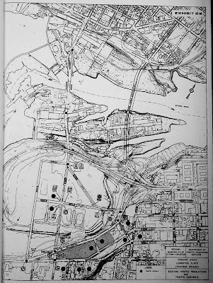
In case you hadn't noticed, this intersection was not built as a "T": This map from a 1973 RMOC study41 shows the old cloverleaf and Wellington-Parkway connection superimposed over the new Y-shaped intersection of Wellington, Portage, and the Parkway.
That study went to the RMOC's Roads and Traffic Committee on 1973-07-04 recommending "an immediate start on connecting roadways to channel traffic to and from the [Portage] bridge." In addition to four pages of recommendations to close, reconfigure, and renaming many of the streets in LeBreton Flats, the plan also recommended setting aside aside for exclusive bus use "the portion of Wellington Street known as the Wellington Street ramp, between Fleet Street and the Ottawa River Parkway."42
The LeBreton Flats changes appear to have been approved by RMOC Council on 1973-08-08, including with a request to the City of Ottawa "to consider a change in street name" whereby Wellington between Scott and Rochester be renamed to Scott, Wellington between Rochester and a new roadway link connecting Albert to Wellington be renamed Albert, and the section of Wellington between Hill and Commissioner be renamed "Wellington Crescent or Hill Street".43 I haven't yet looked for the City's response to this recommendation, but it's fairly clear that these name changes didn't happen.
When a similar report on reconfiguration of Wellington Street rose to Regional Council on 1973-10-24 (which I also need to look into), council referred the matter back for further study of "alternatives for eastbound and westbound traffic on Wellington Street west of Bay Street", and "Councillor W. Ryan ... requested an explanation as to why Wellington Street (in the vicinity of the National Library) was turned over to the National Capital Commission and what, if any, compensation was received."44
The report that came back to Regional Council on 1974-07-10 gave an insight into traffic patterns on the former loop ramp according to a 1970 traffic count: westbound traffic on Wellington approaching the former loop ramp had been mostly destined for the Ottawa River Parkway (61.6% a.m. peak, 72.4% p.m. peak), with 14% each destined in the morning for Chaudière bridge and the federal government parking lot, only 3.3-4.7% destined for Bronson southbound and 5.7%-7.9% destined for Wellington westbound (toward Scott Street). As for the disposition of Wellington Street, the report noted that, while Ottawa City Council had approved the connection of Wellington to the Ottawa River Parkway on 1967-04-17, "the Wellington Street right-of-way has never been turned over to the National Capital Commission and accordingly, there has been no compensation received for the right-of-way." Regional Council approved the LeBreton Flats road closures (including the portion of Wellington Street west of Hill Street) and left the matter of the "the conveyance of any part of the Wellington Street right-of-way to the National Capital Commission, to be dealt with in the context of a development plan for the Lebreton (sic) Flats area."44
This formal closure of the section of Wellington between Hill Street (now known as Brickhill St) and Broad Street was protested by west-end residents but ultimately approved.45 "This will force all east-bound Wellington traffic to funnel into the central core along Slater Street,"46 leaving Wellington in three-and-a-half pieces: From Rideau to the Ottawa River Parkway, Hill Street to west of Bay Street (eastbound only), Broad Street to Scott Street at Bayswater/Bayview, and west of the tracks to Western Avenue near Island Park Drive.
The westernmost portion of this section of Wellington still exists to this day, abandoned under the embankments of Albert Street and Booth Street toward the former Broad Street intersection:
Finishing touches
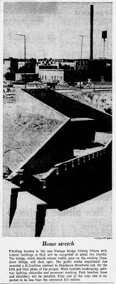
The fifth and final contract award for the Portage Bridge was announced on 1973-09-11 to Deschenes Structures Ltd. for "landscaping, pathway lighting, sidewalks and pavement marking." The "Home Stretch" as the Citizen called it:47
The NCC's 1974-1975 annual report shows the Portage Bridge completed in the distance, leading to the still-under-construction Place du Portage complex.48
There were a couple of final hiccups before the November 1973 opening, including a proposal to rename the bridge for Louis St. Laurent (instead "a bus lane across the Portage will be named in his memory").49 The other was an announcement of a delay until the Spring due to "new plans to integrate parking facilities of the new Place du Centre complex with Quebec-side approaches to the bridge".50
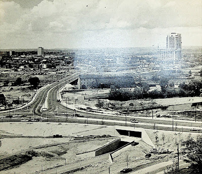
Without the landscaping, the tunnels under Wellington Street really stick out:51
But the bridge opened to motor traffic at 10 a.m. on either Friday, 1973-11-09,52 or Saturday, 1973-11-10;53,54 accounts differ in the Citizen and Journal. Pedestrian access was postponed until the Hull connections were completed.53 The first "road mishap"—a rollover in which the driver was brought to hospital in "satisfactory condition"—came on the following Friday.55
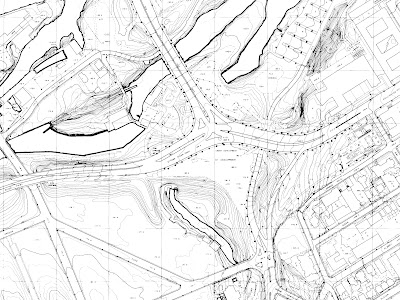
And here's how it looked from above, on a late-1970s topographic map, including only a vestigial eastbound connection between Wellington and its former self:56
Within days of opening, the NCC permitted commercial traffic up to 8,000 lbs on the bridge,57 either due to lifting of technical restrictions, or because traffic volumes so far had been manageable.58
"A brief ceremony" to officially open the Portage Bridge was held on 1973-12-17 by Public Works Minister Jean-Eudes Dubé and Urban Affairs Minister Ron Basford. Dubé attributed the bridge to "the close cooperation that exists between the governments and the NCC."59 But the opening was clouded by infighting between NCC Chair Douglas Fullerton and various current and former ministers. Basford was reported as being "curious as to why the new Portage Bridge has done nothing to lessen congestion on the parkway", as new traffic signals at Wellington and Portage backed up afternoon rush-hour traffic along Wellington Street all the way to Confederation Square.60 That must have been after this photo of minimal traffic volumes on the bridge was taken:61
Indeed, the bridge was called "Fullerton's Folly" by Controller Ernie Jones46,45 and by West End residents, after the man "whose baby it was,"60 but in the article announcing the bridge's official opening, Fullerton fought back:59
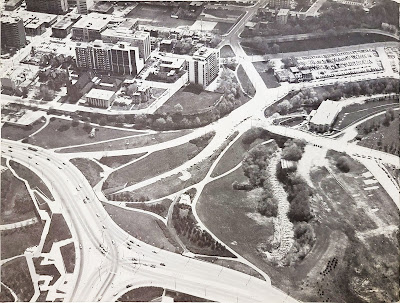
"It was Senator [Arthur] Laing, then the federal minister of public works, who made negotiations over the bridge with the Ontario provincial and the Ottawa municipal governments impossible..."To summarize, the insertion of the Portage Bridge caused Wellington to lose its cloverleaf connection to itself, leaving just this vestigial section of Wellington around to link up with the Cliff Street road under the bridge to the federal government parking lots, as seen in this aerial photo from a 1985 NCC report:62
"When cabinet gave the NCC the authority to proceed with the bridge," says Mr. Fullerton, "I was instructed to take time off – a month, if necessary – to negotiate with Ottawa city hall and Queen's Park on the approaches and resulting traffic flow.
"But almost at the same time, giving me no chance to even approach city hall or the Ontario people, Arthur Laing called in the press and spilled the whole story of the bridge plans.
"He made the bridge an accomplished fact as a firm policy decision of the federal cabinet."
According to this privately-produced (and therefore not official) map dated 1976, the Ottawa River Parkway connected to Wellington at its eastbound link, and Wellington still connected to its Broad-to-Bayview section eastbound via its previous route, and westbound via Lyon and Albert. This map also shows the cleaned up road configuration in LeBreton Flats.63
The next post in the series will be about the impact of rapid transit on Wellington Street (again, the LeBreton Flats section), but I have a lot more work to do on that one, and at the current pace it could be over a year until it's ready. Until then, why not check out this URBSite post on the Brutalist architectural elements of the Portage Bridge? Perhaps by the time I get to present day the federal and local governments will have sorted out what will happen to Wellington in front of the Parliament buildings.
As always, I've done my best to filter out the wrong information and provide sources for the rest; corrections are welcome by email, tweet, or comment (all comments are moderated).
Show/hide references
- 1: ▲ "PA-145782." Library and Archives Canada, Aerial photo via Taylor, John H., Ottawa, an Illustrated History, p. 195.
- 2: ▲ Hume, J. A. "10 Govt. Buildings Planned To 'Beautify' Central Area." Ottawa Citizen, 1962-04-19, p. 1.
- 3: ▲ Bond, Courtney C. J. Where Rivers Meet: An Illustrated History of Ottawa. Windsor Publications, 1984, p. 131. Bond also notes that Fullerton 'blocked or weakened municipal and regional arterial road plans, assisted public transport, and generally set out to make Ottawa a very liveable and attractive city' and he initiated both the pathway programme and skating on the Rideau Canal.
- 4: ▲ Gréber, Jacques. ""Part III: Schedule of execution: Long range operations"." Plan for the National Capital. National Capital Planning Service, Ottawa, 1950, pp. 267, item 22.
- 5: ▲ Gréber 1950 p. 250.
- 6: ▲ "Restoring Old Beauty Of Chaudiere Falls." Ottawa Citizen, 1949-04-30, p. 23.
- 7: ▲ "Enhance Beauty Of Ottawa And Hull (photo with caption)." Ottawa Citizen, 1949-04-30, p. 21.
- 8: ▲ Lynch, Charles. "Start New Chaudiere Bridge Within 2 Years." Ottawa Journal, 1952-11-07, pp. 3, Cols 1-3.
- 9: ▲ Information Division, Federal District Commission. The National Capital Ottawa & Environs (Map), 1958, The anticipated bridge cuts through the second D (sic) of Baldwin Street on the map to connect to Montcalm.
- 10: ▲ Smith, Wilbur & Associates. Traffic and Transportation Plan for Ottawa, Canada. Wilbur Smith and Associates (New Haven, CT), 1955, p. 168.
- 11: ▲ Smith 1955 pp. 170-171.
- 12: ▲ Hammer, Philip. Ottawa Central Area Study, 1969. Hammer, Greene, Siler Associates, 1969, No page number; fold-out plate at the back.
- 13: ▲ Campbell, Norman. "MP raps mayor on growth report." Ottawa Citizen, 1970-01-06, p. 3.
- 14: ▲ Connolley, Greg. "New bridge over Ottawa to be builtin 20 months." Ottawa Citizen, 1970-02-26, p. 1.
- 15: ▲▲▲ Jackson, Richard. "New 6-Lane Bridge to Hull." Ottawa Journal, 1970-02-26, p. 1 & 4. The article continues on Page 4.
- 16: ▲ NCC Annual Report (1969-1970), part one. National Capital Commission, 197, p. 13.
- 17: ▲▲ National Capital Commission. NCC Annual Report (1970-1971), part one. National Capital Commission, 1971, p. 10.
- 18: ▲ "NCC repeats Hull bridge, sewer plan." Ottawa Citizen, 1970-04-24, p. 3.
- 19: ▲▲▲ "$13 million bridge focus of fight." Ottawa Citizen, 1972-07-21, p. 1.
- 20: ▲ "Controllers blast bridge decision." Ottawa Citizen, 1970-04-25, pp. 3, Cols 3-4.
- 21: ▲ "Can City Afford 'Gift' of Bridge?." Ottawa Journal, 1970-04-28, pp. 4, Cols 1-2.
- 22: ▲ Jackman, Peter. "Not opposed to Ottawa-Hull Bridge Plans–Robarts." Ottawa Journal, 1970-04-28, pp. 4, Cols 1-2.
- 23: ▲ "Views on bridge misunderstood." Ottawa Citizen, 1970-05-28, pp. 16, Col 1.
- 24: ▲ "Hull Bridge Plan Support Denied." Ottawa Journal, 1970-06-25, p. 5.
- 25: ▲ Clingen, Ron. "Marchand Cools bridge Controversy." Ottawa Journal, 1970-07-30, pp. 1, 8.
- 26: ▲ "Britannia Bridge by 1974?." Ottawa Journal, 1970-11-12, p. 1.
- 27: ▲ "Ontario rejects Portage Bridge project." Ottawa Citizen, 1971-07-08, p. 3.
- 28: ▲ "Portage Bridge contract signed." Ottawa Citizen, 1971-10-06, p. 3.
- 29: ▲ "Ottawa-Hull rapid transit [from page one]." Ottawa Journal, 1971-10-20, p. 2.
- 30: ▲▲ "$1.5 million contract let for Portage Bridge work." Ottawa Journal, 1971-11-19, p. 1.
- 31: ▲ "Montreal firm wins contract for new bridge." Ottawa Citizen, 1971-12-29, p. 3.
- 32: ▲ "Portage phase four tenders in." Ottawa Journal, 1972-05-03, p. 10.
- 33: ▲ "$5,331,092 Portage Bridge project granted Dibblee." Ottawa Citizen, 1972-06-19, p. 48.
- 34: ▲ "City of Ottawa Archives/MG159/CA011668." Alex Onoszko collection (aerial photography). City of Ottawa Archives, Accessed on 2022-01-12, This photo also appears in the Journal 1972-08-26 (https://www.newspapers.com/clip/40267937/aerial-photo-of-portage-under-constructi/) and a cropped version on page 96 of the Ottawa Construction Association's 125th anniversary book.
- 35: ▲▲ Jackson, Richard. "Traffic lights to help ease Portage bind." Ottawa Journal, 1972-07-21, p. 1.
- 36: ▲ "Mighty 'whoomp' clears way for Portage Bridge access." Ottawa Journal, 1973-04-13, pp. 2, Cols 4-6.
- 37: ▲ "Wellington Street ramp to Hull will close." Ottawa Journal, 1972-07-20, p. 16.
- 38: ▲ "The Regional Municipality of Ottawa-Carleton Council Minutes No 10: Executive Committee Report Number 6/59: Regional Road System." RMOC Minutes, 1973. Regional Municipality of Ottawa-Carleton, 1973-06-27, pp. 1333,1336,1352. This doesn't necessarily mean the closure of these streets, merely that they would no longer be considered arterial streets under the RMOC's jurisdiction.
- 39: ▲ National Capital Commission. NCC Annual Report (1972-1973), part one. National Capital Commission, 1973, p. 15.
- 40: ▲ The Heart of the Capital (Map). National Capital Commission, ca. 1972, This map is an enlarged reproduction from the NCC's Guide to Canada's Capital. A copy appears in the OPL's Ottawa Room.
- 41: ▲ Department of Traffic Engineering Services. "Exhibit 2.2: Existing Traffic Regulations and Traffic Controls." Traffic Study: LeBreton Flats (Portage Bridge). The Regional Municipality of Ottawa-Carleton, 1973, p. 5.
- 42: ▲ ""Work planned for roads up to Portage bridge." Ottawa Journal, 1973-07-05, p. 3. From the article: 'The plan will also require closing of small sections of several streets in the LeBreton Flats area near the bridge approaches, some street name changes, as well as numerous traffic signal and parking adjustments. / The one-way designations on Booth Street, from Fleet to Oregon Streets; on Duke, from Fleet to Booth; and on Fleet from Booth to Duke will be rescinded. / Albert Street, as well as the new roadway link connecting it to Wellington, and Wellington Street between Hill and Broad Streets will be designated one-way westbound. Albert Street, between Rochester and Slater, will become one-way eastbound.'.
- 43: ▲ "Executive Committee report 8/81, Roads and Traffic Committee report number 9 to the executive committee: LeBreton Flats (Portage Bridge) - Traffic Study." RMOC Minutes, 1973. Regional Municipality of Ottawa-Carleton, 1973-08-08, pp. 1800-1806.
- 44: ▲▲ "Regional Council Minutes, July 10th, 1974, Roads and Traffic Committee Report 11 (pp. 14-21)." RMOC Minutes, 1974. Regional Municipality of Ottawa-Carleton, pp. 2292-2299. Note that the description of the 1973 RMOC meeting is from the 1974 minutes.
- 45: ▲▲ "Jones blasts region, NCC." Ottawa Citizen, 1974-07-11, p. 4.
- 46: ▲▲ Lyons, Rick. "NCC traffic policies draw fire from council." Ottawa Journal, 1974-07-11, p. 3.
- 47: ▲ "Home stretch (photo and caption)." Ottawa Citizen, 1973-09-11, p. 2.
- 48: ▲ National Capital Commission. NCC Annual Report (1974-1975), part one. National Capital Commission, 1975, p. 32.
- 49: ▲ "Bridge to stay Portage–not Louis St. Laurent." Ottawa Citizen, 1973-11-07, p. 1.
- 50: ▲ "New parking scheme stalls bridge opening." Ottawa Citizen, 1973-10-02, p. 1.
- 51: ▲ Minton, Eric. "The view from Christ Church Cathedral Hill ca. 1880, & 1974." Ottawa...the way we were. Nelson, Foster and Scott Ltd., Willowdale, Ontario, 1975, p. 31.
- 52: ▲ "Portage Bridge open for traffic." Ottawa Citizen, 1973-11-10, p. 2.
- 53: ▲▲ "Portage bridge opens Saturday." Ottawa Journal, 1973-11-09, p. 1.
- 54: ▲ "New Bridges (Photo with caption)." Ottawa Journal, 1973-11-12, p. 3.
- 55: ▲ "Woman dies, others hurt in crashes." Ottawa Journal, 1973-11-17, p. 2.
- 56: ▲ "Ottawa 1:2,500 Scale Topographic Maps (1966-1980) 366060." Ottawa Resource Collection: Historical. Carleton University MacOdrum Library, Accessed on 2019-11-24.
- 57: ▲ "Advertisement by NCC." Ottawa Journal, 1973-11-16, p. 58.
- 58: ▲ "Bridge Use Light." Ottawa Citizen, 1973-11-13, p. 3.
- 59: ▲▲ "Won't be 'fall-guy': Fullerton blames Laing for Portage hassle." Ottawa Journal, 1973-12-17, p. 1.
- 60: ▲▲ "Parkway plug: West End traffic flush-out eyed by NCC." Ottawa Journal, 1973-12-14, p. 3.
- 61: ▲ National Capital Commission. NCC Annual Report (1973-1974), part one. National Capital Commission, 1974, p. 40.
- 62: ▲ Urban Design Guidelines: Bronson-Portage Link with the Ceremonial Routes. National Capital Commission, 1985, p. 6.
- 63: ▲ Ottawa-Hull & Environs (map, revised 1976). AllMaps?, 1976, Map is in the Ottawa Room at the OPL.








One of the pictures posted in this blog has those streetlights that I remember seeing in my childhood (I'm born in the 2nd half of the 1980's), when other people (like my parents) were crossing the Portage bridge while driving me. However, these streetlights did get replaced at some point, around the year 2000 if I'm not mistaken.
ReplyDeleteOne of the pictures posted in this blog has those streetlights that I remember seeing in my childhood (I'm born in the 2nd half of the 1980's), when my parents or other people used to cross the Portage bridge while driving me. However, the streetlights did get replaced at some point (around the year 2000 if i'm not mistaken).
ReplyDeleteUnfortunately, I'm having a hard time finding other old/archived pictures of the Portage bridge with the old street lamps (not counting the pictures with the bridge at bird's-eye view in which the streetlights are only seen as faint vertical lines).