Tuesday, August 17, 2021

Wellington Street Part 8: Viaduct traffic, Journaled

Part 8: Viaduct traffic, Journaled

   [Show/Hide Contents]

Although I set out in October 2019 to write this Wellington Street blog series looking to learn about the street's various connections and disconnections, the last three parts, ending with a look at a 1950s traffic study were a bit of a sidetrack.

The last connection change was back in Part 4 when the Wellington Street Viaduct was built in 1909 (overtop an existing route). As it happens, the next major change to Wellington Street that we'll look at is when the viaduct was replaced.

The Viaduct gets an entire post thanks to the Ottawa Journal's obsession with its role as a bottleneck for afternoon rush-hour traffic.1
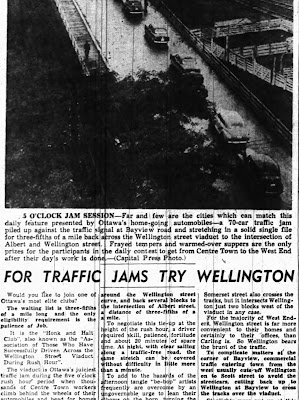
1940s Newspaper article with heading For Traffic Jams Try Wellington, with a bird's eye photo of a line of cars on the Wellington St Viaduct, captioned 5 O'Clock Jam Session.

Monday, May 24, 2021

Wellington Street Part 7: Dawn of "Modern" Transportation Planning in Ottawa

Part 7: Dawn of "Modern" Transportation Planning in Ottawa

   [Show/Hide Contents]

If A.E.K. Bunnell's 1946 report covered in Part 5 recommended a few tweaks to the road network, and the 1949 Gréber report we looked at in Part 6 reimagined large swathes of the City's buildings and transportation network, a January 1955 report report on traffic and transportaion in Ottawa by consultants Wilbur Smith & Associates came in somewhere in the middle. No renamings or disconnections of Wellington Street in this installment, this time we're going on full traffic nerd mode.

This 245-page report1 took a detailed snapshot of traffic in Ottawa, and made a number of specific recommendations, many of which involved Wellington Street. In today's part of the Wellington Street blog series, we'll dive into this report and see what it had to say about traffic in general, and Wellington in particular, in the mid-1950s.

Image of the blue cover of the spiral-bound report in the Ottawa Public Library's Ottawa Room

Sunday, April 25, 2021

Wellington Street Part 6: Postwar traffic on Wellington

Part 6: Postwar traffic on Wellington

   [Show/Hide Contents]

Back in January 2020, we left off with Part 5, in which we watched traffic get heavier on Wellington Street from the 1910s to the 1940s. After a hiatus to do more research and life getting in the way, we're now back to look at government interventions in and around Wellington Street in the ten years following the end of World War II.

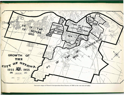
The biggest change for the City of Ottawa was on January 1, 1950,1 when Ottawa annexed nearly all nearby developed area, including Westboro, Ottawa West, Hampton Park, Highland Park, Woodroffe, Laurentian View, McKellar, Britannia, etc. Thich comprised 7,420 acres (3,000 hectares or 30 square kilometres) of Nepean and Gloucester Townships,2 as seen in the two large sections on the map below.3 Much of this was burgeoning suburban development which fed a daily stream of workers into downtown Ottawa.

Map of City of Ottawa from 1955 showing annexations/expansions up to that point, starting with Town of Bytown 1850 City of Ottawa 1855 in the middle and the largest expansions reading Pt of Twp of Nepean 1950 and Pt of Twp of Gloucester 1950.

Although Richmond Road was thus brought into the City limits, it retained its name west of Western Avenue, where Wellington ends.4 Since there were no major physical changes to Wellington Street specifically in this period, today's post will look at traffic in general on Ottawa's Wellington Street.