Showing posts with label City Hall. Show all posts

Friday, November 15, 2019

Confirmed: Fleet Street uses water to pump water

I'd like to correct the record.

On October 1 of this year, while attending a drop-in Open House about the City of Ottawa's plans to rehabilitate the Booth Street heritage bridge (more on that to come in a future blog post), a City representative mentioned offhandedly that the Fleet Street water pumping station had been converted to electric pumps "decades ago", like in the 1950s.

One of the LeBreton Flats residents in attendance, echoing the sentiment of many, expressed dismay that he'd been telling people for years that it was a water-powered water pumping station. I, myself, had made this claim in my 2012 blog post 3D Through the Aqueduct (part 2).


While still at the Open House, I did a quick Google search on my phone, and found only unsubstantiated claims. A City employee working on a project about one of the aqueduct's bridges is a pretty compelling authority. My next step was to send out a Tweet calling on the crowdsourcing power of Twitter to confirm or deny these electric claims.


That yielded nothing conclusive. There was a City report describing the pumping station as water-powered, but that report was prepared by the Councillor's office, not the water department.

I eventually (Oct 17) emailed Councillor McKenney, who sent the request down the bureaucratic ladder, and the very next day I got this wonderfully clear and detailed response from Paul Montgomery of the City's water department. (Emphasis added, slightly edited).
Mr. Akben-Marchand,

There are five water turbine powered centrifugal pumps at the Fleet Street pumping station; all are still used and in service. A small amount of electrical power is required, for automated controls, lighting and such, but the primary sources of motive power for the station's installed pumps is water and, of course, gravity.

Many people incorrectly assume that we use the river, at Fleet Street, to drive generators which would then drive electric motors and, in turn, to drive pumps. Rather, we use water powered turbines to drive mechanical gear boxes / speed increases to then directly drive the installed pumps.

Approximately 20m3/s of Ottawa River water flows, through a headworks control gate structure located along the shore of Nepean Bay, through the covered Aqueduct below the former Ottawa Street, to the Fleet Street Pumping Station and then down through the turbines. The approximate head, across the turbines, is 27 feet.

Treated drinking water flows by gravity, through a large buried watermain from the Lemieux Island Water Treatment Plant, to supply the five pumps at Fleet. At full capacity, the Fleet Street pumping station can supply approximately 200ML/day to the City.

Thanks,

M. Paul Montgomery, P. Eng.
Plant Manager, Water Production - East
Water Services, PWES

That settles that! I publish it here for posterity, and for the next person who hears rumours of the plant's electrification!

By the way, that "200ML/day" refers to Megalitres per day, or 200,000,000 litres! I discussed the underground Ottawa Street aqueduct in this 2012 blog post.

LeBreton Flats updates/errata


On the topic of corrections and updates, here are some to some previous blog posts about LeBreton Flats:
  • In the 2012 post, 3D Thursday: 3D through the aqueduct, part 2 of 2, I didn't know the purpose of the wooden bracing on the Fleet Street Pumping Station building. A CBC Ottawa News video from 2013 says that the City was doing repairs to cracks that developed on both the pumping station and Pooley's Bridge following blasting at the site of nearby condo development on Lett Street.
  • The tree featured in the 2014 post, The Lonely Elm was cut down in Winter 2014-2015 (literally: the two nearest photos showing the tree present and absent were on 2014-12-21 and 2015-03-28). The price of progress for LRT and, it would seem from aerial photos, the Combined Sewage Storage Tunnel (CSST) access shaft.
  • Also in the Lonely Tree post, I referred to a section of Wellington Street as "Old Wellington", which was incorrect. It would have just been "Wellington".

I actually have a number of LeBreton Flats related blog posts in various stages of development that I hope to publish soon, including the results of quite a bit of research about Wellington Streets.

[Look for more one-photo posts under the label Singles]

Thursday, May 9, 2013

3D Thursday: 1966 Batmobile at Ottawa City Hall in 3D

This mornming, the Batmobile is visiting City Hall as a publicity stunt for Ottawa Comicon, and will be at Marion Dewar Plaza at 11:45am. I grabbed a 3D shot of it as it was being prepared for its appearance. Click for full size:


I also tweeted a photo of four By-Law officers (including a By-Law supervisor) eyeing the car, but none of them were up to giving it a parking ticket.
[Tune in on Thursdays at noon for a new 3D image. View the 3D label for other posts with 3D images. 3D FAQ] [Look for more one-photo posts under the label Singles]

Monday, April 15, 2013

Bixi's back for 2013

As of today, Capital Bixi is back in action! For subscribers like me, that means my key should work for the remainder of my one-year subscription (which I bought last June). And for you readers of my blog, that means I'm going to blog about it!


I never got around to blogging my Bixi photos last year (and the year before, my season-opener blog post used photos from the 2009 pilot), so I get to include some of those with this post. For example, the one above was taken last June at the Museum of Nature's east lawn, at Elgin and McLeod. On Saturday night, the bikes had been re-installed, though it was decidedly snowier:

Wednesday, March 27, 2013

Painting on the Mackenzie-King Bridge

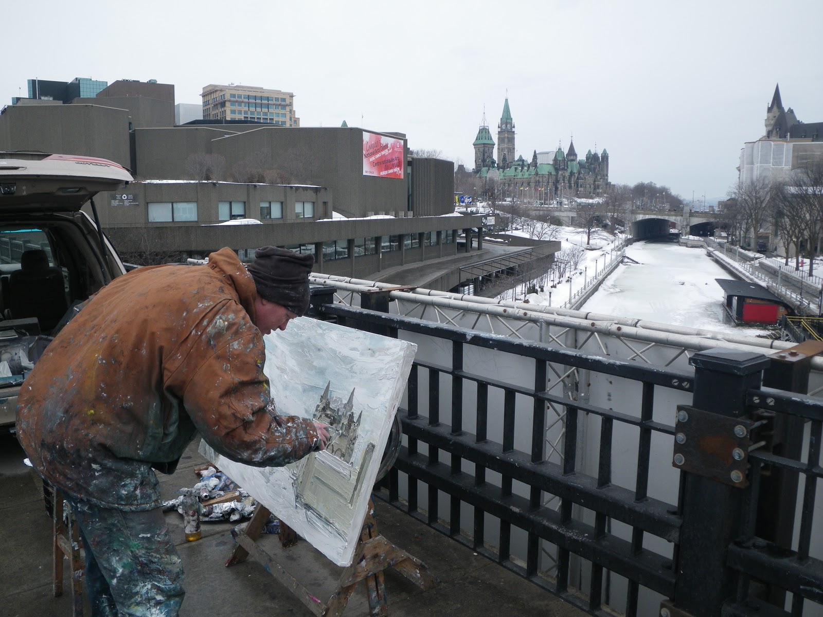
You might have heard earlier this month about Patrick Mills painting every day in March on the Mackenzie-King Bridge. I made a point of going to visit him shortly after that story broke, chatted with him a bit, and of course took a photo:


He has a blog where he keeps track of his regular progress.

A couple days after reading about his work, I recognized one of them staring me in the face as I walked out of the office on the second floor of City Hall (between the elevator bank near the Laurier entrance and the rotunda):


This had just recently been installed, as part of the recent trend to spill out the City's art collection on the otherwise unused wall space.

Patrick is painting every day in March, of which there aren't too many left. So if you want to check him out in person, don't wait too long!

Monday, March 18, 2013

One last (hopefully) blast of winter

The weather forecast suggests that we'll be getting another 20-centimetre blast of snow in the next couple of days. This might be my last chance this year to get some of my winter-related photos out before trying to forget that season and focus on spring and summer. So here goes.

Here's an inuksuk I built outside Bridgehead on Elgin after a snowstorm in December. It was one of those ones with really sticky snow. A couple of days after falling, that sticky snow had hardened into snow you could cut chunks from.


That was actually from the storm pictured below on Gladstone, where the snow 'flakes' were the size of frosted mini wheats. I hope this week's storm doesn't bring us this heavy stuff:

Tuesday, March 5, 2013

Winter cycling, Ottawa, 2013

Even though Citizens for Safe Cycling's 2nd Ottawa Family Winter Bike Ride was over a month ago, I got some photos at unique angles that are worth sharing. Plus, you know, we're still cycling and (despite all protests) it's still Winter.

One of the neat photos I got was this one, from the second floor of City Hall. Get a load of the shadow on that bike at the bottom:


Here's another shot, of CfSC President Hans Moor giving a pre-ride pep talk to the group. He had his own writeup on the ride, which includes a photo of yours truly. That thing on my pant pocket in his photo is the tripod I used to get this high-angle shot:


I went ahead of the group on Laurier to get some shots of the group approaching. People were dismounting to cross the barricade because the snowbank had not been cleared in the opening at Percy to allow a left turn. Cars in both directions waited very patiently for the cyclists to cross.


On another note, there is a public open house tonight to reveal the City's plans for Albert Street through LeBreton Flats. This will (hopefully) show the outcome of the pedestrian report devised from the walkabout in October. It is at 7-9pm at the Dalhousie Community Centre, room 31. As far as I understand, it's a drop-in type event so you don't have to come for the whole duration.

Monday, August 27, 2012

Capital Pride 2012

Yesterday was the annual Capital Pride Parade, which is orders of magnitude more populous than the last time I was able to get to Pride, back in 2005.

My usual group, the Human Powered Vehicle Operators of Ottawa (who won Best Float in the 2004 Pride parade) didn't participate this year, so instead I hitched along with the fine folks from the Dusty Owl Reading Series.

The parade was huge, and the crowds were immense. At the end of the parade, everyone files into Marion Dewar Plaza at City Hall for the Pride celebrations (or otherwise disperses). We were float number 80 of 84, so most of the parade was already in by the time we got there. And yet there were still hundreds, if not thousands, of people still clamouring toward the Plaza behind us:

China Doll (centre) is a fixture of Ottawa's Pride parade, harking from the Shanghai Restaurant, the first Chinese restaurant to open in what is now considered Chinatown. China Doll puts on a raucous Karaoke on Saturday nights that is hilariously over-the-top.

I hope you had a chance to make it to the celebrations, and if not, come next year!

Wednesday, April 25, 2012

Peds on Weds: Footpath of dreams

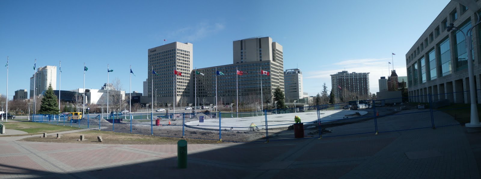
When the Rink of Dreams was built—hastily—last fall, the work naturally disrupted the flow of pedestrians around Marion Dewar Plaza between heading north and east from the Laurier street entrance of Ottawa City Hall. The early thaw highlighted this disruption even further, but workers are now restoring the pathways, as seen in this panoramic view from earlier this month (click to view full size):

Since the boards around the rink are removed in the off-season, it will be possible to walk on it unobstructed. Indeed, one of the former paths is restored, directing pedestrians right over the surface. It will also be used for events in the summertime, such as the upcoming second annual Capital Vélo Fest in early June.

For more Pedestrians On Wednesday reading, I recommend The Invention of Jaywalking, published yesterday in The Atlantic. The article is acommpanied by a 1909 editorial cartoon which depicts a motorist speeding through newspaper headlines of pedestrians struck by cars. Eric Darwin has also posted this morning a review of recent research conducted on walkability and socio-economic status in different neighbourhoods in Ottawa over at West Side Action.

[Look for more one-photo posts under the label Singles]

Friday, February 17, 2012

Rink of Dreams

As has been widely reported, the Rink of Dreams is now open on the Laurier side of Ottawa City Hall, on Marion Dewar Plaza. It's refrigerated, so it will still be open this weekend even if weather forces the canal to close. It's also free to use.

Mayor Watson is hosting a Family Day skating party this coming Monday from 11am to 2pm, with free hot chocolate. Details available on Jim Watson's website

[Look for more one-photo posts under the label Singles]

Friday, January 27, 2012

CfSC's winter parade

This past Sunday, Citizens for Safe Cycling organized Ottawa's first winter bike parade. Many others have posted their photos and writeups already, and I've put links to those at the end of this post.

The cyclists gathered at the snowed-over community garden along Laurier at Percy Street. It was encouraging just getting there, as there were three other cyclists in the bike lane on Bay Street as I was heading up.

Monday, October 31, 2011

Ottawa City Hall: my new haunt

[Edit: I left City Hall in October, 2015, after four years working in the Somerset Ward office for Diane Holmes (2011-2014) and Catherine McKenney (2014-2015)]

Mayor Watson decorated City Hall's heritage building (which is the part of City Hall that houses his office) for Hallowe'en, and it looked great! It appears that I only have one previous Hallowe'en-themed post, which also included a photo of City Hall, back from the first year of this blog.

Sorry for the gap in posts; I've been busy at a conference, and getting settled in to my new job. In case you hadn't heard the news (or the Buzz), I stepped down last month as president of the Centretown Citizens Community Association to take a job in the office of Councillor Diane Holmes.

Two weeks ago I was busy at a conference and didn't have time to prepare any blog posts for last week, which was my first week at the new one. A complicating factor is that I'll be part-time at both, and the transition is a bit time-consuming.

Nevertheless, I already enjoy being back on Elgin Street, after my office moved away last year. Commuting to City Hall will give me a chance to cross the neighbourhood a few times a week to keep an eye on things, and keep my camera on them too. Similarly, commuting to my West office will have me crossing Bronson Avenue a couple of times a week and keeping an eye on Chinatown, Little Italy, and the rest of the former Dalhousie ward.

It's a lot to handle, but keeping all those balls in the air is a challenge I'll enjoy.

Happy Hallowe'en!

[Look for more one-photo posts under the label Singles]
Monday, August 29, 2011

Andrew S. Haydon Hall

City Council hasn't met for a couple of months, as City Hall for the most part goes on summer holidays. It'll be back in September, which is just around the corner!

[Look for more one-photo posts under the label Singles]

Friday, August 5, 2011

Accessible Upgrades at City Hall

Over at OpenFile, there's a thread on accessibility; specifically, spaces that aren't designed with all users in mind. This comment reminded me of a recent renovation to Ottawa City Hall's information desk in the rotunda, seen here during an art exhibit in mid-June:

For reference, here's a December 2009 file photo showing what the info desk used to look like:

In May, I saw workers installing a countertop. Once I clued in to the gap cut into the counter, I realized it was to allow wheelchair users to communicate with the person behind the desk.

Since I'm a tall person (I took some of these photos from the second floor--I'm not that tall!), this accessibility obstacle hadn't occurred to me until I saw them fixing it.

It's good to see it occurred to someone. And it didn't require a whole new desk, either. Just some small modifications.

Friday, July 1, 2011

Happy Canada Day from Ottawa! #ottbike

Happy Canada Day! Here's a photo of my bike decked out in red and white Christmas lights at Capital Vélo Fest.

Mine was one of the many HPVOoO bikes on the June 4, 2011 night ride. There are more photos linked from the HPVOoO 2011 events Gallery and on the Capital Vélo Fest website

I'll be busy at the Bluesfest Bicycle Parking for Citizens for Safe Cycling the next couple weeks, so I might miss a few posts. See previous posts with the Bluesfest label.

[Look for more one-photo posts under the label Singles]

Monday, June 20, 2011

The City Hall link

One of the reasons I have so many photos of Ottawa City Hall, aside from being there a lot on community association business, is that it has lots of interesting architectural features.

Take, for example, the second floor connection between the main building and the Heritage building. It looks great at night (this photo is from before they redid the floors in 2009):

It's also arched to mimic the windows on the heritage building:

But a detail I didn't notice until this year was the extra two little pieces of metal to turn this semi-circular vent grill into two pointed arches:

Friday, April 29, 2011

Elgin Promenade

Parallel to Elgin Street, just a few metres East, there's a wide pathway that connects Laurier to Lisgar, going past the Universal Declaration of Human Rights memorial, City Hall's Heritage Building (the former Ottawa Normal School), and the Ontario Courthouse.

It's great in concept, except I don't think it really works. The sidewalk along Elgin there is as narrow as it can be to make this walkway as wide as possible, and as a result there's not enough room for people to stand as they wait for the bus.

Not that there would be a pedestrian crossing so close to the intersection, but even if there were the promenade couldn't continue north of Laurier or south of Lisgar: to the north is Confederation Park, whose layout isn't really compatible with this vista; and to the south is Knox Presbyterian Church's third location. It's previous location, further up Elgin Street, "was expropriated for the widening of Elgin approach to the proposed Confederation Square. Granted a new lot at Elgin and Lisgar in compensation, the church is in possession of a letter from Prime Minister WL Mackenzie King promising that they would never be moved again." (from URBSite).

Even though it's not along the path of a pedestrian going along Elgin, it's still a reassuring example of space reserved for pedestrians instead of being swallowed up by parking and turning lanes.

[Look for more one-photo posts under the label Singles]

Friday, March 4, 2011

Envirocentre

EnviroCentre, according to their website, "is a non-profit organization that works to reduce greenhouse gas emissions by delivering energy-efficiency goods and services." They have a number of programs to help households and building/property owners improve their energy efficiency, including energy efficiency audits to help you get a tax credit to renovate your home.

EnviroCentre's offices are located at City Hall, which is provided in-kind by the City. They've recently opened a second EnviroBoutique on Rideau Street.

[Look for more one-photo posts under the label Singles]

Monday, January 10, 2011

Fixed! Streetpost at Bank and Queen

Riding around town on December 30, I was standing at the corner of Bank and Queen streets, and noticed that the lamppost was crooked at the north-west corner. It looked like there was a kink in the post behind the poster collar, dangerously threatening to fall into traffic on Queen Street.

I don't know how long it had been like that (or if it had been previously noticed and reported), but I phoned it in to 3-1-1 anyway just in case. By January 5, when I was next around there, it was already replaced with a brand new post:

Nice to see the prompt response by the City over the holidays.

[Look for more one-photo posts under the label Singles]

Monday, November 8, 2010

Rescue Bronson Avenue this Wednesday!


By now you have hopefully heard of the Rescue Bronson Avenue initiative at RescueBronson.ca. The group was started by the Centretown Citizens Community Association, the Dalhousie Community Association, the Centretown Citizens Ottawa Corporation and councillor Diane Holmes in response to the reconstruction plans for Bronson Avenue from Sparks Street to the Rideau Canal.

We're holding a public meeting on Wednesday, November 10, 2010 at 7pm at McNabb Community Centre, assembly hall, to Rescue Bronson Avenue!

See below for how you can help and the background.

Rescue Bronson: What can you do?

Background on Rescue Bronson Avenue

The underground infrastructure beneath Bronson Avenue is over a century old and needs replacement. As a result, there is an opportunity to revise the way Bronson Avenue looks on the surface. At this point, it looks like work will be done in 2011 from Arlington to Gladstone, 2012 for Gladstone to Gloucester, and 2013 for Gloucester to Sparks.

The City's engineers (and the consultants they hired) want to rebuild Bronson Avenue exactly as it is: a four-lane arterial with no room for cyclists, pedestrians, or front yards. In some places, they even want to widen Bronson's lanes and narrow the sidewalks.

While we invited to a public consultation group, our feedback fell on deaf ears. The road would be rebuilt first, then plans could be made for landscaping. When the community said we want more trees on Bronson Avenue, the consultants replied there wasn't enough room, and proposed fake trees instead.

When we asked for a pedestrian crossing between Gladstone and Catherine, they proposed one at Flora--because it was halfway between--instead of at Arlington, where most pedestrians cross.

When we pointed out that traffic volumes are much lower north of Gladstone, and were low enough to look at a road diet (which would reduce crossing distances for pedestrians and provide space for landscaping, while carrying the same amount of motorized traffic), we were stonewalled.

Here's Bronson Avenue today. The City's engineers want to make the outer lanes wider, which will encourage motorists to speed past each other on the outside lane around left-turning vehicles in the centre lane. Any cyclists or crossing pedestrians in the way won't be seen until it's too late.

By contrast, here's just one way Bronson can be reconfigured to improve flow. No more jockeying for position.

Other alternatives include parking lanes with bulbouts for trees, a middle lane that changes direction during the day, and others (see more examples in Eric's post on a recent Toronto road diet). The point is that the City isn't even considering any of these ideas. The numbers we've seen indicate that traffic north of Gladstone is low enough to warrant a road diet, but the City insists on the status quo.

The same "status quo" message goes for the triangle at the north end, between Albert and Slater. This slanted section through the escarpment is unfriendly to all modes of travel, yet the most the City would propose is a slight narrowing to reduce pedestrian crossing times, or perhaps a "refuge island" so pedestrians could cross in two stages. Surely this is the right opportunity to look at reconfiguring this awkward triangle?

The City's engineers and consultants haven't proposed any solutions because they've prepared their designs before even listening to what the community's problems are.

While Rescue Bronson has identified some problems (like those above), we're sure there are more out there. So please come to the public meeting on Wednesday and help show your support to Rescue Bronson Avenue!

Wednesday, October 20, 2010

Cycling Updates

I made two cycling-related posts in September, and have some updates on both of them...


New Post-and-Ring racks: are there enough?
(Original post)

At the Copenhagen talk, the City's presentations aid 600 racks would be installed, up from the 550 racks I'd previously reported. After the talk, I spoke with Robin Bennett, the City's cycling coordinator. He said that the 600 figure is final, now that the study is finished, and he described the methodology of the study, which includes a buffer for growth in demand.

Robin gave two important take-home messages:

(1) The City will be holding onto the posts from the removed parking meters, and the rings are cheap--the main cost in installing more bike racks is labour; and

(2) The City will be installing them where their study said they'd be necessary. If there are places that need more racks, the City will add them, but need feedback from cyclists where these places are. Contact 311@ottawa.ca if there are places that need racks.

[Edit: I have since seen the complete list of where existing parking meters are located and how many post-and-ring racks are to replace them, and can confirm that the replacement numbers are grossly inadequate. In response to my complaints, Robin now says that there is no budget to add bike racks. Furthermore, the blue Velocity bike racks have been removed for the season.]

Lyon Street Repaved: Cyclists get their sharrows?...
(original post)

A bike lane has indeed been installed on Lyon Street through Centretown, and Sharrows have been installed at key locations, like here crossing Somerset Street West. (see image above)

Sharrows have a dual goal of directing cyclists along a route (e.g. around turns or through intersections), and of reminding motorists to expect cyclists there (particularly where a lane isn't practical, like through intersections).

Unfortunately, where the bike route turns right onto Arlington to take people over to Percy to continue South, the lane just ends. It needs some sharrows going around the corner and continuing to Bay.

I'm a big fan of sharrows, and I describe their use in Montreal in part 2 of the upcoming series.