In the previous entry of the series on
What I learned in Montréal, we looked at Montréal's Chinatown and gateway arches.
This time, I'd like to look at something Montréal is known for in Ottawa's cycling community: segregated bike lanes. There has been much talk in Ottawa about getting segregated bike lanes installed here (and while there was much controversy in the initial suggestion that Somerset was the best street, the latest suggestion is for Laurier Avenue - see
here and
here)
I wanted to see for myself how they worked, what they did well, and what they did poorly. Were the horror stories as bad as I'd heard? Can such lanes in Ottawa be compared apples-to-apples? Also, what else is different about Montréal's cycling infrastructure from Ottawas, and is that difference better or worse? I'll be looking at other cycling-related themes in parts 6 and 7 of the series, on Bikes on Métro and Bixi bikes/bike parking, respectively.
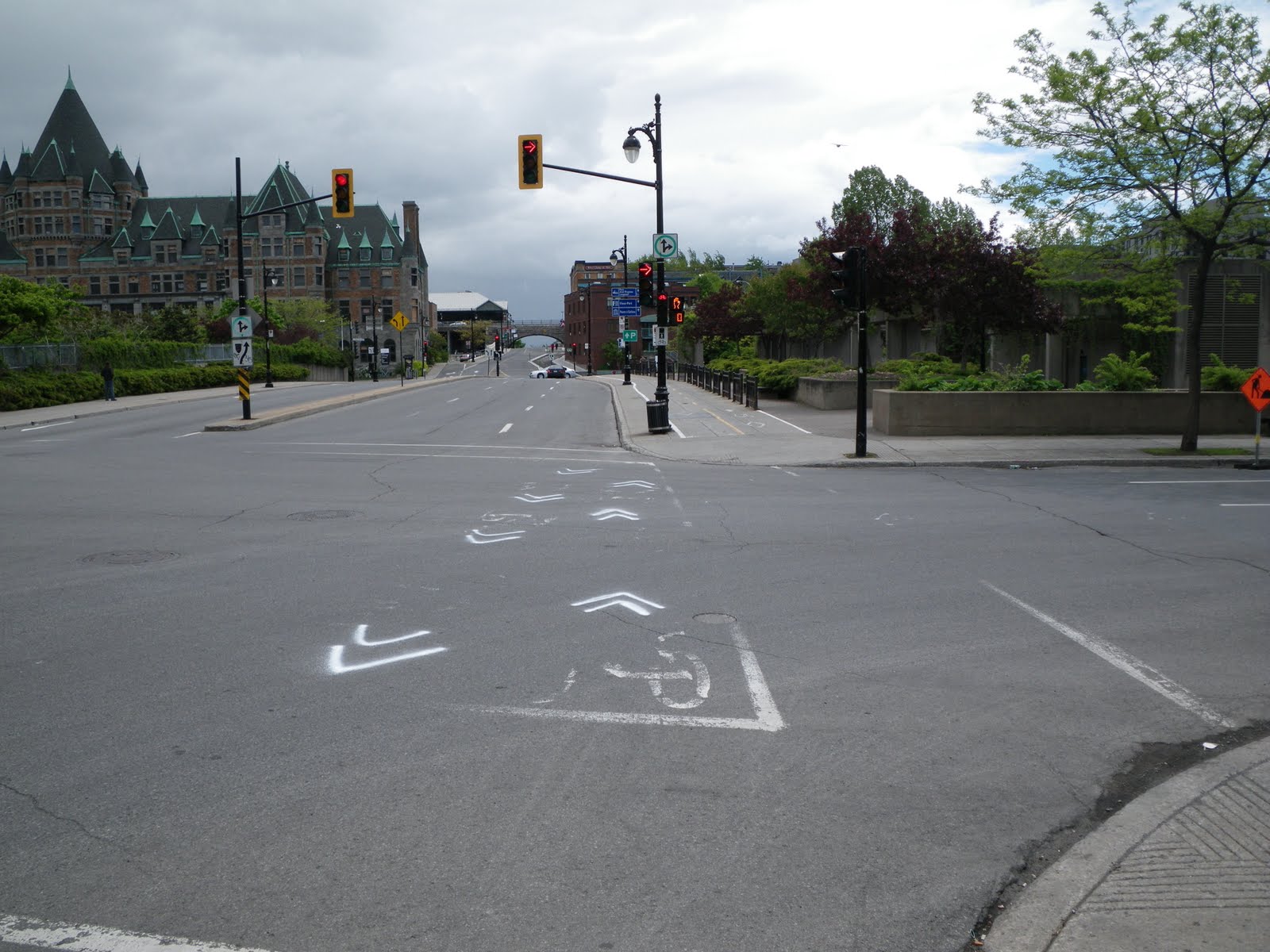
The intercity bus terminal is at Bérri and Maisonneuve, and underneath it is the massive Bérri/UQAM métro station, which serves three lines. Just across the street from the bus terminal was a large Bixi station and a segregated bike lane.

The first thing you notice is that this is a very wide street, with large institutional buildings along it that don't have frequent intersections or driveways cutting across it. The segregated bike lane is bidirectional and reasonably wide, with a concrete median with green posts. I'd say the closest to this type of street in downtown Ottawa would be King Edward Avenue North of Rideau or Sussex around NDHQ. Most, if not all, streets in Centretown are much narrower than this.
Looking at the other direction, we see how the bidirectional Bérri lane interacts at the intersection of Maisonneuve. The bike lane is flush with the intersection, and there are sharrows through the intersection (as was done for Ottawa's newest bike lane on Lyon Street as it crosses through Somerset, as shown in Wednesday's post). Motorists turning onto Maisonneuve (like the silver car in the photo below) have a green straight arrow, and must wait for a solid green to turn right. This gives pedestrians and cyclists a protected crossing, though there isn't a dedicated traffic signal for cyclists. It looks like there's a bus stop on the median, but we didn't wait to see how that worked with the bike lane in the way.

A bit further South along Bérri and Saint-Antoine, a new section of segregated bike lane has recently been completed, with sharrows solidly through the intersection. There are two traffic signals for all southbound traffic, each on the far edges of the road. It's been decades in Ottawa since we converted all our traffic signals to hang in the middle of the intersection, where they are much more visible. Also more visible in Ottawa are the large signs for major crossing streets that are mounted to these poles, making navigation much easier.

If it looks like the sharrows in the above intersection direct cyclists onto the sidewalk, that's because it does. Here's what things look like one block earlier: sharrows from the on-street bike lane direct cyclists to the sidewalk, which is wide enough for a curb separation from traffic, two-way bike lane, fences, pedestrian passage (albeit a narrow one), and landscaping with benches.

The closest we have to sidewalks that wide in Ottawa are along Wellington, which are well used by pedestrians, tourists, statues, and demonstrators. We do have a bike lane on a sidewalk, however--on the leadup to the Alexandra bridge around Major's Hill Park--and like this one it is annoying to go over the sidewalk ruts. A friend of mine crashed hen his wheel got stuck in the rut under the centreline on the Alexandra bridge sidewalk bike path.
Needless to say, a local cyclist we saw riding along this block had a much more comfortable time on the road than we did on the sidewalk!
Elsewhere downtown, there are on-street bike lanes like this one that seems to encourage cyclists to ride in the door zone (where a cyclist gets a "door prize" if a car door opens suddenly in front of them without enough time to stop or swerve). I'd be interested to see what happens when people are loading into or out of the car on the driver's side, or when motorists have to cross the bike lane to get into and out of the parallel parking.

This lane on Saint-Urbain must also be relatively new, because you can see where the old lane markings were scraped off the street. While the lane appears to have been laid far enough from the curb to avoid the door zone, motorists park more lazily away from the curb, treating the bike like a buffer protecting their car from being hit by motorists.
Also note that parking is prohibited between 5 and 6 pm on weekdays, according to the sign at left. Does this mean that the curb lane is used for through traffic in rush hour? This would put motor traffic on both sides of cyclists, which mustn't be fun. That's an important thing to remember about bike lanes: the lane is in only one place, but the best place to ride your bike might differ depending on traffic and time of day/week/year.

Montréal still has some room for improvement. These construction pylons are placed unceremoniously in the bike lane, and it doesn't look like provisions were made for cyclists (we were on foot at the time)

Further out from downtown, some residential streets also had bidirectional segregated bike lanes, which are installed from April to November, like the many Bixi stations peppering the city. As with the Bérri lane, these are separated from cars by green posts, but a lane of parking was used as a buffer from moving traffic instead of a curb. Unfortunately, these lanes are also in the door zone.

Riding down the street on a Saturday late afternoon, the street was deserted except for parked cars, and Meg and I instinctively rode down the centre of the street, as one would on MacLaren or Gilmour in Ottawa. It took us a block or two before we noticed that there was a bike lane on the other side of the parked cars. I wonder whether motorists are aware of the bike lanes when crossing them.
Here's how these lanes play out at intersections. A small, seasonal stop sign is required for the cyclists riding against the flow. Yellow sharrows are painted through the intersections, but these ones on Clark at Fairmount needed re-painting.

It wasn't until I looked back at these photos that I realized that these streets weren't at all comparable to MacLaren and Gilmour. Just look at how wide they are! Take out the bike lanes and a one of thetwo rows of parking, and then you've got something approaching the width of Centretown's residential streets. Even Kent, MacLaren and Lyon aren't that wide. Laurier might be this wide, but it's two-way. There are few laneways, which isn't the case for most of Centretown's East-West streets. So you can't take Montréal's segregated bike lanes and plop them down in Ottawa.
But that doesn't mean there's nothing to learn from Montréal's on-road cycling infrastructure. For example, this anonymous one-way street crossing av. Laurier has sharrows going in the direction of traffic, with a painted contra-flow bike lane going in the opposite direction. (The view of the lane line is blocked by the cargo triker in this photo).

I really like this facility, because it puts both directions of the cycling route on the same street, making directions much easier. In fact, I'd like to see this type of facility on Percy Street North of Flora (with parking moved to the West side), which would greatly help northbound cyclists coming from the Glebe who want to get to Chinatown without having to use Bronson, ride the wrong way on Percy, or jog a long block out of their way to Lyon. While the contra-flow lane is in the door zone in the above photo, you're facing traffic so passengers and oncoming cyclists can see each other--it wouldn't be an issue in Ottawa anyway, since we don't have enough room for parking on both sides.
As with the above intersection, sharrows connect the route through intersections. Interestingly, this street is one-way toward Saint-Joseph from both directions, so the contra-flow lane switches sides. A median prevents motorists from continuing through the intersection and going the wrong way, and the sharrows direct cyclists around it. Perhaps useful for
Stewart at Waller?

Even where there aren't bike lanes, sharrows are still used to denote cycling routes. For example, the sharrows in the photo below tell cyclists that the route continues straight. Where the route turned a corner, the sharrows indicated it (this is needed at the South end of Lyon's bike lane, where cyclists are supposed to turn right on to Arlington to get to Percy to cross under the Queensway. Councillor Holmes and I have been asking for sharrows and bike route signage at Lyon and Arlington, which will eventually come).

Sharrows have the added benefit of reminding motorists that cyclists have a right to use the road, without constraining cyclists to a narrow lane that motorists expect cyclists to ride in--even if they're blocked by debris (glass/gravel), puddles, potholes, or parked cars.
Cycling advocates like bike lanes because they are a tangible reminder that says "you can cycle here", but as mentioned above, it's sometimes impossible to put down a bike lane because it has to be in the same place all day, but the best place to cycle isn't always the same during peak and off-peak hours. Sharrows prove a reasonable compromise that allows cyclists to ride on the part of the road/lane where they feel safest, but motorists still get that reminder.
Signs just
aren't the same as they're often ignored or not recognized. Look at all the signs in this photo and tell me you'd notice, understand and follow them all while driving through this neighbourhood. The yellow sign at the right, for example, has a car and a bike on them, which I know means "[motorists] share the road [with cyclists]", because Ottawa has signs that show a motorist
next to a cyclist and explicitly say "Share the Road / Partagez la route". If you zoom in, you'll notice that every other one replaces the car with an inline skate (definitely
not a sign we use in Ottawa!)

Stay tuned for
part 3 of "What I learned in Montreal," where we go underground to see how the Métro stations function, and what this means for the proposed Downtown Ottawa Transit Tunnel. We'll come back to other cycling issues later in the series.
Edit: further reading on cycling route connectivity is available in the recently-posted Vélo Québec peer review (PDF) of Ottawa's segregated bike lane project. While much of the 23-page report is about segregated bike lanes, route connectivity is addressed as well.
 In the front lawn was a large tree in full fall colours:
 In early November, the tree was removed. While the by-law requires a sign to be posted one week before and one week after the tree removal, this doesn't apply to diseased trees that are a safety hazard (a permit is still required, just no sign).
  Unfortunately, this makes it impossible to distinguish between an illegal tree removal and the legal removal of a diseased tree, as explained by David E. Barkley, Manager of Forestry Services at the City of Ottawa, that month in response to my inquiry:
 Finally, in October 2010, the City installed new trees on the boulevard.
  Down the block and across the street, the Executive apartments at 305 Metcalfe had some landscaping work done in July 2009, removing some brush:
 In this shot from mid-August, there's a fair size tree on the boulevard, maybe eight inches in diameter at chest height.
 But by March 2010, that tree was removed--I'm not sure by whom--leaving just a stump. As you can see in the photo from in front of 296 Metcalfe above, it looks like there weren't any new trees planted in front of the Executive.
 Then not too far away, the Chancery of the Nigerian High Commission has done some exterior renovations as well. At the end of March 2010, we can see three trees along Metcalfe, each three and a half storeys tall, plus shrubs along Lewis:
 By late June, they had removed the trees and shrubs and were preparing to re-sod the lawn.
 They took this opportunity to apply a marble finish to the bare concrete bed at the ground level. This was complicated by the fence right in front of that surface.
 In mid-October, a second fence was added to the building's perimeter, and two small saplings were planted to replace the three large trees. Hopefully they will survive in that narrow grassy boulevard like the three old trees did on the lawn.
 While the loss of five mature trees is troublesome, in a couple of decades the five new trees planted will be big enough to help restore Metcalfe to its former glory, like Kent Street before it was widened, or Bronson Avenue after it is narrowed.


