The Petro Canada at Bronson and Somerset quietly reopened this past Friday after about six months of construction, which started shortly after the reopening of newly reconstructed Bronson Avenue. It comes complete with a convenience store at the corner, seen best at night in HDR.
Even though about three-quarters of Centretown residents walk, bus and bike as part of their regular commute to work and school, the car ownership rate in Centretown is about 1.3 cars per household. So when residents of Centretown, Chinatown and Dalhousie eventually have to fill their tanks, they have to go somewhere. After the closure of the Shell station at Gloucester, this station just on the far side of Centretown's Bronson border is one of the closest to downtown. (I'm not saying I regret the closure of the gas stations that used to pepper Centretown much more heavily!)
But just because a gas station is a car-oriented business, it doesn't mean it can't also fit into the fabric of a walkable urban neighbourhood. Before the construction photos, let's look at how the station used to look:
Showing posts with label Demolition. Show all posts
Monday, March 10, 2014
An urban gas station in Centretown
View other posts on these topics:
Bronson,
Chinatown,
Construction,
DCA,
Demolition,
HDR,
Pedestrians,
Planning and Development,
Somerset,
Stores
Wednesday, February 13, 2013
Peds on Weds: In case of fire hydrant, block sidewalk
View other posts on these topics:
90 Elgin,
Construction,
Demolition,
Pedestrians,
Sidewalks
Ever hear someone talk about a pole in the middle of a sidewalk or path but you suspect they're exaggerating the degree to which it's blocking pedestrians? Well I've got one for you, with a photo to prove it!
I'll quickly run through how it got there (why it did remains unknown...). The fixture in question is on Albert Street, at the site of the Lorne building, which I've blogged about in posts with the label 90 Elgin.
Here's the back of the Lorne building in May 2011, and the Albert Street sidewalk, looking east toward Elgin, with a fire hydrant and street light more or less at the edge of the sidewalk at the left:
Similar angle in August, after exterior demolition started. A rendering of the new building is on a sign:
In late November 2011, the sidewalk was incised down its length about a foot and a half behind the curb line:
The back two thirds of the sidewalk were removed by the end of November. The fire hydrant from previous photos is just on the other side of the streetlight. Ever wonder what's under the concrete of a sidewalk? Well, here's a photo of it anyway:
Piles were driven right at the cut line and wooden 4x4 fenceposts were strapped to them. Early December 2011.
The same scene from the Slater Street side, looking across to Albert. The piles are interleaved with wooden boards to hold the street up, as I described in detail for the EDC building at 150 Slater in a post in August 2009.
While the wasteland of the site is fun, here's a cropped closeup of the same shot. The hydrant is gone. I only noticed looking at these photos that the streetlight was actually strapped to an I-beam pile during this phase of construction. Weird, but I guess it works!
Since Elgin Street is along Confederation Boulevard, the slightly-less-ugly-than-normal NCC spec hoarding was attached to the fenceposts seen in the previous scene. Needless to say, the sidewalk was closed.
...Unless you work there. (Ever notice how big a tower crane's hook block actually is? If I were as far away from it was the tower crane's operator is, I'd be pretty spooked to have it so close to workers!)
The above shot was from June 2012, and it looked more or less the same as it did at the end of 2011.
By Mid-September, the wooden fencing was taken down and replaced with temporary modular metal fencing.
Cropping in again on the photo, the fire hydrant is still there, and, with the blue top indicating it's apparently still in service.
By the end of October, 2012, the streetlight was removed, and the hydrant is yellow. It's actually not the same hydrant as the one before, which suggests it might have been moved also.
In mid-November, they reinstated the sidewalk and put scaffolding over it since the towers were (and are) still under construction right next to it.
Only, uh...
I'm not sure why the hydrant is in the middle of the sidewalk (the one we've been following is in the distance; the one seen here is mid-block, closer to Metcalfe). Maybe the builder and the City couldn't agree on whether to put it at the front or back of sidewalk, so they split the difference.
For now, the scaffolding over it seems to be keeping the snow away. But when that's gone, I'm not sure how sidewalk plows are supposed to make their way along here.
Luckily, it's just a 'temporary' situation. In all likelihood, there will be a standpipe built into the wall of the building, and the sidewalk will be redone with the final, fancy landscaping.
[Tune in on Wednesdays at noon for a new pedestrian-themed blog post. View the Pedestrians label for previous Peds on Weds posts]
I'll quickly run through how it got there (why it did remains unknown...). The fixture in question is on Albert Street, at the site of the Lorne building, which I've blogged about in posts with the label 90 Elgin.
Here's the back of the Lorne building in May 2011, and the Albert Street sidewalk, looking east toward Elgin, with a fire hydrant and street light more or less at the edge of the sidewalk at the left:
Similar angle in August, after exterior demolition started. A rendering of the new building is on a sign:
In late November 2011, the sidewalk was incised down its length about a foot and a half behind the curb line:
The back two thirds of the sidewalk were removed by the end of November. The fire hydrant from previous photos is just on the other side of the streetlight. Ever wonder what's under the concrete of a sidewalk? Well, here's a photo of it anyway:
Piles were driven right at the cut line and wooden 4x4 fenceposts were strapped to them. Early December 2011.
The same scene from the Slater Street side, looking across to Albert. The piles are interleaved with wooden boards to hold the street up, as I described in detail for the EDC building at 150 Slater in a post in August 2009.
While the wasteland of the site is fun, here's a cropped closeup of the same shot. The hydrant is gone. I only noticed looking at these photos that the streetlight was actually strapped to an I-beam pile during this phase of construction. Weird, but I guess it works!
Since Elgin Street is along Confederation Boulevard, the slightly-less-ugly-than-normal NCC spec hoarding was attached to the fenceposts seen in the previous scene. Needless to say, the sidewalk was closed.
...Unless you work there. (Ever notice how big a tower crane's hook block actually is? If I were as far away from it was the tower crane's operator is, I'd be pretty spooked to have it so close to workers!)
The above shot was from June 2012, and it looked more or less the same as it did at the end of 2011.
By Mid-September, the wooden fencing was taken down and replaced with temporary modular metal fencing.
Cropping in again on the photo, the fire hydrant is still there, and, with the blue top indicating it's apparently still in service.
By the end of October, 2012, the streetlight was removed, and the hydrant is yellow. It's actually not the same hydrant as the one before, which suggests it might have been moved also.
In mid-November, they reinstated the sidewalk and put scaffolding over it since the towers were (and are) still under construction right next to it.
Only, uh...
I'm not sure why the hydrant is in the middle of the sidewalk (the one we've been following is in the distance; the one seen here is mid-block, closer to Metcalfe). Maybe the builder and the City couldn't agree on whether to put it at the front or back of sidewalk, so they split the difference.
For now, the scaffolding over it seems to be keeping the snow away. But when that's gone, I'm not sure how sidewalk plows are supposed to make their way along here.
Luckily, it's just a 'temporary' situation. In all likelihood, there will be a standpipe built into the wall of the building, and the sidewalk will be redone with the final, fancy landscaping.
[Tune in on Wednesdays at noon for a new pedestrian-themed blog post. View the Pedestrians label for previous Peds on Weds posts]
Thursday, January 17, 2013
3D Thursday: St. Paul Church (Aylmer, QC)
View other posts on these topics:
3D,
Aylmer,
Demolition,
Fire,
Winter
St. Paul's church in Aylmer is obviously not in Centretown, but it's in the Ottawa area and its ruins will be demolished today. It was consumed by fire after it was struck by arsonist on the evening of June 11, 2009, and has been in ruin ever since. Click on this 3D photo to see it full screen for better effect:
A number of people posted videos of the fire to YouTube, including this shocking one of the high wooden steeple falling into a plume of fire.
A colleague of mine who lives within sight of the church sent me photos the following day, including this one:
When I was in the area a couple of months later, in August 2009, I snapped this photo, which shows signs of some tidying up of the stone walls:
St. Paul's church was a focal point of the town of Aylmer, which was home to many of my ancestors, for example: my grandmother was born in and grew up in a house practically across the street from the church, and her father was Mayor of Aylmer for a few years in the first half of the 20th century (as was his brother-in-law). Both married their respective spouses at St. Paul's.
Recent articles in the Ottawa Citizen and CBC summarize the bureaucratic gridlock that led to the decision to demolish the remains. That conclusion was partly due to the church not being insured sufficiently to allow a full reconstruction, partly due to the local governments' unwillingness to preserve the heritage, and largely due to lawyers' overabundance of caution.
In anticipation of the imminent demolition, I went by for the last time this past Christmas Day to take some 3D photos for posterity.
At least in Centretown, when the Somerset House partially collapsed, we held on to what is left until it can be restored. By contrast, once you tear the buliding down, it's gone forever. Then it, and the history it represents, is easily forgotten.
Which do you remember better: Ottawa's former City Hall at Elgin and Queen, or Lisgar Collegiate Institute?
[Tune in on Thursdays at noon for a new 3D image. View the 3D label for other posts with 3D images]
A number of people posted videos of the fire to YouTube, including this shocking one of the high wooden steeple falling into a plume of fire.
A colleague of mine who lives within sight of the church sent me photos the following day, including this one:
When I was in the area a couple of months later, in August 2009, I snapped this photo, which shows signs of some tidying up of the stone walls:
St. Paul's church was a focal point of the town of Aylmer, which was home to many of my ancestors, for example: my grandmother was born in and grew up in a house practically across the street from the church, and her father was Mayor of Aylmer for a few years in the first half of the 20th century (as was his brother-in-law). Both married their respective spouses at St. Paul's.
Recent articles in the Ottawa Citizen and CBC summarize the bureaucratic gridlock that led to the decision to demolish the remains. That conclusion was partly due to the church not being insured sufficiently to allow a full reconstruction, partly due to the local governments' unwillingness to preserve the heritage, and largely due to lawyers' overabundance of caution.
In anticipation of the imminent demolition, I went by for the last time this past Christmas Day to take some 3D photos for posterity.
At least in Centretown, when the Somerset House partially collapsed, we held on to what is left until it can be restored. By contrast, once you tear the buliding down, it's gone forever. Then it, and the history it represents, is easily forgotten.
Which do you remember better: Ottawa's former City Hall at Elgin and Queen, or Lisgar Collegiate Institute?
[Tune in on Thursdays at noon for a new 3D image. View the 3D label for other posts with 3D images]
Friday, October 19, 2012
Five years since Somerset House collapse
View other posts on these topics:
Bank,
Construction,
Demolition,
Hartman's,
Needs Repair,
Nighttime,
Pedestrians,
Planning and Development,
Police,
Renovation,
Roads,
Somerset
While a petition and articles in both the Centretown News and Centretown Buzz have recently suggested that it happened in November 2007, the collapse of the wall at Somerset House in fact happened exactly five years ago, on Friday, October 19, 2007. In this post, which is the longest so far on this blog with 30 photos, I'll go over some of the highlights on and since that day that mark the ongoing saga of the historic building. Given the milestone, I'm publishing at 9am instead of noon.
As the Citizen reported the day after the collapse (I can't link directly to archived Citizen articles; you'll have to log in to the Proquest database with your Ottawa Public Library card and PIN and search for them), a 44-year old Bobcat operator was stuck under rubble for about two hours when the southeast part of the building collapsed on him just before 3pm.
When I got there around 7:30pm, the whole area was taped off by the fire department, and it was raining hard. The Fire Department had connected tethers from the north sidewalk across the street into the building.
An hour later, a large crane arrived on scene. I didn't stay around for much longer, since it looked like work would continue all night.
As the Citizen reported the day after the collapse (I can't link directly to archived Citizen articles; you'll have to log in to the Proquest database with your Ottawa Public Library card and PIN and search for them), a 44-year old Bobcat operator was stuck under rubble for about two hours when the southeast part of the building collapsed on him just before 3pm.
When I got there around 7:30pm, the whole area was taped off by the fire department, and it was raining hard. The Fire Department had connected tethers from the north sidewalk across the street into the building.
An hour later, a large crane arrived on scene. I didn't stay around for much longer, since it looked like work would continue all night.
Monday, September 3, 2012
Centretown time capsule: August/September 2007
Happy Labour Day everyone!
For today's post, I want to do something a little different. I wanted to give a snapshot of what was happening in Centretown five years ago in August and September 2007. With a high proportion of renters, many Centretown residents—even those active in community affairs—weren't here five years ago (nor was this blog!). For the rest of us, it'll be a trip down memory lane.
The 2007 Labour Day parade, organized by the Ottawa and District Labour Council, ended as usual at McNabb Park for the annual festival with free hotdogs, corn on the cob, and other attractions (if you're reading this post shortly after it goes up, head out there now! They should be there from the end of the parade until 4:30pm). You might recognize this photo of the wading pool as one of the four at the bottom of the CCCA's 'promo cards':
September 2007 marked the official opening of the Corktown Footbridge on the 11th (the bridge opened to traffic the previous September). Municipal politicians and interpreters in 1830's period dress were there to cut the ribbon.
For today's post, I want to do something a little different. I wanted to give a snapshot of what was happening in Centretown five years ago in August and September 2007. With a high proportion of renters, many Centretown residents—even those active in community affairs—weren't here five years ago (nor was this blog!). For the rest of us, it'll be a trip down memory lane.
The 2007 Labour Day parade, organized by the Ottawa and District Labour Council, ended as usual at McNabb Park for the annual festival with free hotdogs, corn on the cob, and other attractions (if you're reading this post shortly after it goes up, head out there now! They should be there from the end of the parade until 4:30pm). You might recognize this photo of the wading pool as one of the four at the bottom of the CCCA's 'promo cards':
Thursday, August 23, 2012
New Series - 3D Thursdays: Lansdowne Coliseum demolition
View other posts on these topics:
3D,
Construction,
Demolition,
Introduction,
Lansdowne Park
Since I posted my earlier 3D images, I've refined the process to get the 3D images looking pretty good, and I'm getting a collection of them going. Which means it's time to start putting them out on the blog!
So here it is: every Thursday, I'll post a new 3D image. Standard red/blue 3D glasses* are required. I'll also post the two source images that went into it, in case you think you can do it better (or if you want to use the wiggle method to view them).
Today's 3D image is of the lamentable demolition of the Coliseum building at Lansdowne Park. The Ottawa Citizen has a number of photos, including historical photos, accompanying its writeup of the demolition. (CBC also has an article)
I'd wanted to share this photo of the Aberdeen Pavillion and Horticulture Buliding, with a "DANGER" sign in front of it, in a separate post, but I'd might as well stick it here:
Here are the source images for the 3D Coliseum image. There are plenty of tutorials online to show you how to combine them into a 3D image. Here's the left image:
And here's the right image:
As a special treat to those of you who've read this far, here's my public Picasa web album of 3D photos. It updates automatically when I make a new one on my computer, so there isn't always a description for it (that's what the blog posts are for!). As you can see, I have a lot of them to work with, though many of them are in related sets. There's apparently an RSS feed on the album which might work; I don't currently have a functional RSS reader. Tip: click on the image to view the full resolution image, and zoom in to see things in the background pop out.
I hope you enjoy now getting four days a week of regular updates!
*If you don't have a pair of 3D glasses kicking around at home from the promotional poster you got in high school, you can buy them for $2.99 at the Comic Book Shoppe on Bank at Lisgar (they're on the display next to the front caah). Let me know if you find any other places to find them in Centretown. I have a few extra and usually have a spare pair with me to give to people.
[Tune in on Thursdays at noon for a new 3D image. View the 3D label for other posts with 3D images]
So here it is: every Thursday, I'll post a new 3D image. Standard red/blue 3D glasses* are required. I'll also post the two source images that went into it, in case you think you can do it better (or if you want to use the wiggle method to view them).
Today's 3D image is of the lamentable demolition of the Coliseum building at Lansdowne Park. The Ottawa Citizen has a number of photos, including historical photos, accompanying its writeup of the demolition. (CBC also has an article)
I hope you enjoy now getting four days a week of regular updates!
*If you don't have a pair of 3D glasses kicking around at home from the promotional poster you got in high school, you can buy them for $2.99 at the Comic Book Shoppe on Bank at Lisgar (they're on the display next to the front caah). Let me know if you find any other places to find them in Centretown. I have a few extra and usually have a spare pair with me to give to people.
[Tune in on Thursdays at noon for a new 3D image. View the 3D label for other posts with 3D images]
Wednesday, August 8, 2012
Peds on Weds: Not half bad for a temporary fix
View other posts on these topics:
Construction,
Demolition,
Pedestrians,
Sidewalks,
Singles,
Sparks
With the already-narrow west end of Sparks Street reduced further between Bay and Bronson to accommodate construction work at Christ Church Cathedral, pedestrians were relegated to the north sidewalk, which is all of a couple feet wide. It looks like the firm doing the work has widened the sidewalk temporarily with asphalt to allow pedestrians and wheelchair users to continue to Bronson.
A hack job, but it does the trick. (A previous version actually proposed to close this section of roadway once the condo was built and install a large piazza in front of the church, but as I understand it, that idea was dropped due to red tape with the City)
[Tune in on Wednesdays at noon for a new pedestrian-themed blog post. View the Pedestrians label for previous Peds on Weds posts]
[Tune in on Wednesdays at noon for a new pedestrian-themed blog post. View the Pedestrians label for previous Peds on Weds posts]
Monday, February 27, 2012
Tools of the dig
View other posts on these topics:
90 Elgin,
Albert,
Construction,
Demolition,
Elgin,
Singles
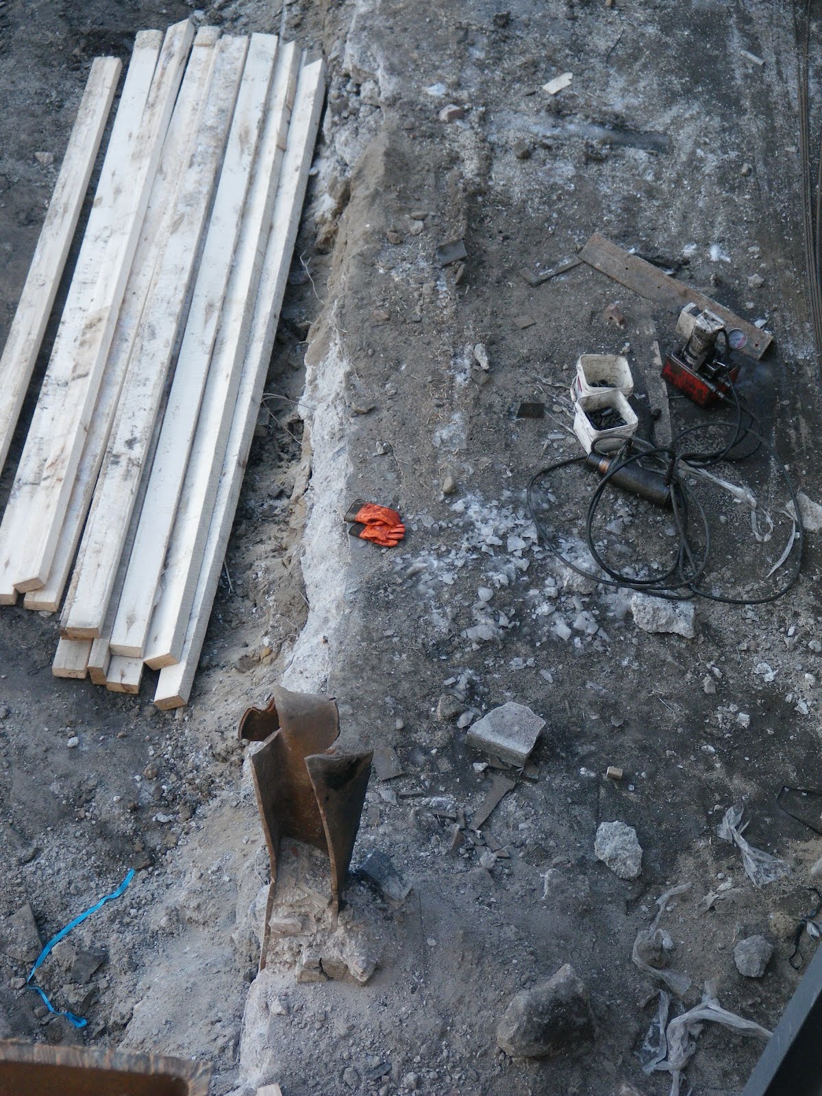
Over at 90 Elgin's construction site, they've dug as far as the footings of the former Lorne Building, and are using that as a ledge while they continue digging within the boundaries of the new building's basement. A twisted I-beam and some tools are resting on the ledge. You can watch the construction on this site. Click on the still image to see a live video feed from the site.

(The following text is repeated from the September 2011 post, Centretown Flyover)
I wrote a post on the context and history of the Lorne Building in October 2009.
There are also three articles on the Lorne Building at URBSite:
(The following text is repeated from the September 2011 post, Centretown Flyover)
I wrote a post on the context and history of the Lorne Building in October 2009.
There are also three articles on the Lorne Building at URBSite:
- Renderings of the proposed building
- History of the development of the Lorne building (the one being demolished, and its predecessors)
- The Lorne building's opening, early photos of it after opening, and related architecture
Monday, January 23, 2012
Uppertown Winter Walk
View other posts on these topics:
Demolition,
Parking,
Parliamentary Precinct,
Pedestrians,
Sidewalks,
Singles,
Supreme Court of Canada,
Winter
On the same day I took photos of the Temporary Building, I took a lot of other photos, despite the frigid cold freezing my batteries. For all the talk of snow clearing on Laurier, this path (for pedestrians) between the Supreme Court and Library and Archives Canada was a lot clearer than many other sidewalks.
The Temporary building (a.k.a. the Justice Annex) is in the background on the left, with its white wooden siding removed.
[Look for more one-photo posts under the label Singles]
[Look for more one-photo posts under the label Singles]
Wednesday, January 18, 2012
Imminently, Temporary to be "formerly" permanently
View other posts on these topics:
CHP,
Demolition,
Parliamentary Precinct,
Singles
I figured a tongue-twister would be a good follow-up to the previous post on the subject of an eye-twister. The demolition order was issued last week, and work has begun with removal of the trim and siding.
Incidentally, this street is called "Vittoria", a name that long predates the current federal buildings surrounding it.
Links to more details on this building are in the post from last month, Temporary Eyetwister.
[Look for more one-photo posts under the label Singles]
Incidentally, this street is called "Vittoria", a name that long predates the current federal buildings surrounding it. Links to more details on this building are in the post from last month, Temporary Eyetwister.
[Look for more one-photo posts under the label Singles]
Monday, December 12, 2011
Temporary eyetwister
View other posts on these topics:
CHP,
Demolition,
Parliamentary Precinct,
Singles
The last temporary building, a.k.a the "Justice Annex", is slated for imminent demolition. The federal office building, built during World War II to house federal workers, was last occupied in 1998--the same year it received federal heritage designation.
These are its side doors. I have other photos of this building, some of which were used by URBSite in its posts about the building and about the temporary buildings more generally.
Public Works and Government Services Canada (PWGSC), the agency responsible for maintaining federal buildings, has decided that it is too expensive to repair this building, and instead will demolish it. This reminds me of some quips made earlier this year that it would be cheaper to demolish and replace 24 Sussex Drive than the estimates to repair it (thankfully, I no longer find any such references).
The CCCA has written to Public Works and MP Paul Dewar to oppose the demolition of this building, as has Heritage Ottawa in a letter supporting the CCCA's position. This is the last of the wartime buildings, and its loss will remove a reminder of the enormous effort that went into fighting the war--even on the home front by the civil servants who worked in these buildings. It is inevitable that veterans will eventually die, but buildings can be repaired and maintained. It is quite a disappointment that we will lose this heritage.
[Look for more one-photo posts under the label Singles]
These are its side doors. I have other photos of this building, some of which were used by URBSite in its posts about the building and about the temporary buildings more generally.Public Works and Government Services Canada (PWGSC), the agency responsible for maintaining federal buildings, has decided that it is too expensive to repair this building, and instead will demolish it. This reminds me of some quips made earlier this year that it would be cheaper to demolish and replace 24 Sussex Drive than the estimates to repair it (thankfully, I no longer find any such references).
The CCCA has written to Public Works and MP Paul Dewar to oppose the demolition of this building, as has Heritage Ottawa in a letter supporting the CCCA's position. This is the last of the wartime buildings, and its loss will remove a reminder of the enormous effort that went into fighting the war--even on the home front by the civil servants who worked in these buildings. It is inevitable that veterans will eventually die, but buildings can be repaired and maintained. It is quite a disappointment that we will lose this heritage.
[Look for more one-photo posts under the label Singles]
Friday, September 23, 2011
Centretown flyover
Small planes over Centretown aren't that uncommon; there is a regular route by a historic biplane that does tours from the Aviation museum and for $100 they'll take you all the way downtown (I'll have to try that myself some day).
This one was flying behind the crane at the demolition site of the Lorne building on Elgin street.
I wrote a post on the context and history of the Lorne Building in October 2009.
There are also three articles on the Lorne Building at URBSite:
This one was flying behind the crane at the demolition site of the Lorne building on Elgin street.
There are also three articles on the Lorne Building at URBSite:
- Renderings of the proposed building
- History of the development of the Lorne building (the one being demolished, and its predecessors)
- The Lorne building's opening, early photos of it after opening, and related architecture
Friday, September 16, 2011
Reflections on the Crowne
View other posts on these topics:
Albert,
Demolition,
Hotels,
Lyon,
Pedestrians,
Queen Street,
Renovation
Both URBSite and West Side Action covered the renovations to the entrance to the Delta Ottawa City Centre hotel (previously the Crowne Plaza hotel and originally the Skyline), on September 5 and 7, respectively. WSA also has a post from February showing renderings of the new entrance displayed in the lobby. [Sep 2013: updated WSA links, both originals were broken]
Well, I've taken a few photos of the hotel over the years myself, and a couple days after the other two did, I went down to get my own shots of the renovations. I tried to get some angles that weren't covered in the other blogs, like this one of the hotel reflected in the glass of Constitution Square:
You can sorta make it out in that picture, but it's much clearer in this crop of a photo from August: the door on the 24th floor coming out the side of the building, which Eric refers to in one of his above-referenced WSA posts. As he mentions, it was used to access the inside of a former illuminated sign on the side of the building, in order to replace the bulbs without having to hoist a crane.
Well, I've taken a few photos of the hotel over the years myself, and a couple days after the other two did, I went down to get my own shots of the renovations. I tried to get some angles that weren't covered in the other blogs, like this one of the hotel reflected in the glass of Constitution Square:
Wednesday, June 15, 2011
340 McLeod demolition
View other posts on these topics:
Bank,
Construction,
Demolition,
McLeod,
Metropolitan Bible Church
We've known for a long time that the former "Medical Building" at 340 McLeod (near Bank) would likely be demolished for Phase 3 of the Central condos at Bank and McLeod (Phase 1 is currently under construction, with the Metropolitan Bible Church façade). This was recently confirmed at City Hall, where the rezoning application was approved with adjustments made based on CCCA feedback.
Most people see the building from Bank Street (like at Tommy & Lefebvre), but here's another view looking across the block from Argyle, here in late May...
And again just this past weekend, where they have begun demolition. While 340 McLeod goes down for Central Phase 3, Central Phase 1 is well on its way up behind it.
I haven't been by there since the weekend so I don't know how far along the progress is on demolition. If you know, please leave a comment.
Most people see the building from Bank Street (like at Tommy & Lefebvre), but here's another view looking across the block from Argyle, here in late May...
Wednesday, October 13, 2010
Yellow House going down today
View other posts on these topics:
Demolition,
Gladstone,
Guest Posts,
Yellow House
The Yellow House on Gladstone is finally being demolished today, after the demolition permit was approved by City Council on September 8, 2010.
Images of Centretown reader Eric Russell submitted the following photos and video, which he must have taken just minutes before I got there:


Thanks, Eric!
For background on the Yellow House, start with the post Yellow House Redevelopment from June 2009, then check out other posts (including this one) with the Yellow House label.
Thanks, Eric!
For background on the Yellow House, start with the post Yellow House Redevelopment from June 2009, then check out other posts (including this one) with the Yellow House label.
Thursday, April 29, 2010
Tommy & Lefebvre Reconstruction: Part 5
View other posts on these topics:
Bank,
Construction,
Demolition,
McLeod,
Planning and Development,
Tommy and Lefebvre
The new T&L store opened yesterday at noon. I got there shortly thereafter and got some photos of the inside... which will wait until the end of this series.
Last time, I talked about the demolition of the last bit of the building. Today there are some things to see on the site preparations. Non-Construction site groupies might want to look away.
Toward the end of May 2009, a few days after the demolition started, the empty shell of the basement was cleared of debris, though the interior walls remained.
A week later, those walls were removed, too. If you zoom in, you can see where the floor joists used to fit into the wall. The hodepodge of colours, surfaces, and textures on the remaining wall looks like a piece of abstract art.
Not to mention the somewhat out-of-place chimney.
I'm not quite sure what these two holes were for; possibly they had been columns in the basement, or possibly the floor was simply broken up.
These two holes are where the ceiling beams connected to the wall, which are also visible in the Previous post.
The rest of the site has been covered over with sand until construction starts.
And in this view we see the whole site from further back on McLeod. The Bio-Ped Foot Care Centre sign isn't there any longer (it and the Café McLeod sign have been repurposed for the roof of the pedestrian walkway on Bank between Gladstone and McLeod. Look up next time you're walking through there).
The T&L demolition happened to occur at the same time as the Bank Street reconstruction was doing its digging. As a result, pedestrians had to walk along what was essentially a narrow ledge of ground lined by 6' Modu-Loc fencing. This photo was taken in late July 2009.
And it was around this time that T&L was applying for approvals, which were obtained in record time with the support of the CCCA. This is an early rendering, which was later modified to increase signage and enhance the cornice.
This is the last part of the series that looks at the demolition--the next part will be twice the usual length, and we'll get knee-deep in construction! Tune back in in two days.
Last time, I talked about the demolition of the last bit of the building. Today there are some things to see on the site preparations. Non-Construction site groupies might want to look away.
This is the last part of the series that looks at the demolition--the next part will be twice the usual length, and we'll get knee-deep in construction! Tune back in in two days.
Tuesday, April 27, 2010
Tommy & Lefebvre Reconstruction: Part 4
View other posts on these topics:
Bank,
Demolition,
McLeod,
Tommy and Lefebvre
This post is the fourth in a series on the resurrection of the Tommy & Lefebvre store at Bank and McLeod. In this part, we'll look at the demolition of the third building that made up the former store.
The first two buildings were sufficiently damaged by the fire that they could be taken down immediately, but the third portion required a Council-approved permit for demolition, because it's in a Heritage Conservation District. The uncontroversial permit was approved by City Council on 22 April 2009.
This set of photos are a bit more interesting because I managed to get there while they were tearing it down. Here's the front of the building, with the pit of Bank Street under reconstruction at the left:
Toward the back of the site, the debris was being loaded into a large bin. You can also make out some of the second-storey rooms.
This one still had a poster hanging on the wall.
But it had fallen by the next day. I like it when the diggers frame each other like this. The yellow one on the right is from the Bank Street reconstruction.
Here's another angle, showing the pile of debris being cleared. It looks like there may have been some smoke or fire damage near the floor of the front room.
I was rather surprised at the size of the second storey, which was entirely obscured when you looked at it from the ground level. The horizontal windows near the front of the second storey are interesting.
Inside the store. If I recall correctly, this was the cycling department--at least in the summer. They've cut the floor joists and the walls so that the adjoining building doesn't get damaged when the machines pull this one apart.
Looking back toward McLeod.
This is the next building over, at Flora Street. I suppose the façade of this building also dates from when Bank Street was widened, and might be hiding multiple conjoined buildings behind it. The Vietnamese Kitchen put a sign in its window reading "closed for renovations," which was still there last time I checked.
The wall connecting the Vietnamese Kitchen building and the T&L building was at least five bricks thick.
The façade bricks peppered the pavement when demolished, sometimes in intact blocks. The bricks look as though they could be re-used.
I'm not sure if they were, though. Looks like everything was just taken away as quickly as possible. Can't say I blame them; they wanted to rebuild as fast as possible--remember, they're in the business of selling sports equipment, not real estate.
Tune in in another two days at noon for the next installment. For a sneak preview of that one, check out the Google Street View Time Machine (which is to say that the Street View photos taken along Bank Street are from the time of Part 3, but if you click to go down McLeod, the photos are from the time of the Part 5.
Also, the T&L website says that the opening date and details will be posted there on Wednesday:
The first two buildings were sufficiently damaged by the fire that they could be taken down immediately, but the third portion required a Council-approved permit for demolition, because it's in a Heritage Conservation District. The uncontroversial permit was approved by City Council on 22 April 2009.
This set of photos are a bit more interesting because I managed to get there while they were tearing it down. Here's the front of the building, with the pit of Bank Street under reconstruction at the left:
Tune in in another two days at noon for the next installment. For a sneak preview of that one, check out the Google Street View Time Machine (which is to say that the Street View photos taken along Bank Street are from the time of Part 3, but if you click to go down McLeod, the photos are from the time of the Part 5.
Also, the T&L website says that the opening date and details will be posted there on Wednesday:
Subscribe to:
Posts (Atom)