A couple weeks ago, I was asked on Mastodon (the only social media where I'm active any more) for photos of car parking spaces converted to bike parking corrals. I figured I'd compile them into a blog post, as it's the kind of thing I used to blog about.
As it turns out, most of the examples I know of in Ottawa are actually onstreet car parking space conversions, and most of the photos I have of them will be in a large unsorted digital pile of photos. But I have two examples that fit the bill closely, and a bunch of other interesting examples:
Showing posts with label Cycling. Show all posts
Showing posts with label Cycling. Show all posts
Sunday, May 3, 2026
When car parking becomes bike parking
View other posts on these topics:
Bank,
Bixi,
Cycling,
Elgin,
Hartman's,
Hintonburg,
Jack Purcell,
Laurier,
MacLaren,
Montreal,
Parking,
Toronto,
Waverley,
Wellington


Wednesday, April 30, 2014
Jane's Walk Ottawa 2014 this weekend
This weekend (May 3-4, 2014) is the annual Jane's Walk Ottawa series of free urbanist walking tours, and as with last year, I'm publishing a list of walks in Somerset Ward.
I mentioned two of the walks I went on last year in my blog posts The Lonely Elm (Dennis van Staalduinen's walk on Wellington Street, who this year is giving a walk in Champlain Park) and The stones don't fall far from the hill (Quentin Gall's talk on Ottawa's Building and Monument Stones), both of which seem to have been one-offs.
Here's the rundown of Jane's Walks in Centretown for this year:
Monday, March 17, 2014
How the Corktown Footbridge got its name
View other posts on these topics:
Canal,
CCCA,
Cycling,
Footbridge,
Media,
Pedestrians,
Planning and Development,
Somerset
I know I just posted a blog post about the Corktown Footbridge, and I've previously covered the opening, but in honour of St. Patrick's Day—and my just-over-one-eighth Irish heritage—I'm reprinting the article I wrote in this month's issue of the Centretown Buzz, telling the story of my time on the naming committee for what is now the Corktown Footbridge.


Thursday, February 13, 2014
3D Thursday: Bicycles and icicles
View other posts on these topics:
3D,
Canal,
Confederation Park,
Cycling,
Footbridge,
NCC,
Winter
This past weekend, Citizens for Safe Cycling's third annual Family Winter Bike Parade ended at 8 Locks' Flat, where a number of bike racks were laid out for us on the patio, which we diligently filled. A number of cyclists had already left by the time I took this photo:

Mike from the Ottawa Bicycle Lanes Project posted a Vimeo video of the ride.
As I left 8 Locks' Flat, I noticed some people had hung some posters from the Corktown Footbridge. If you zoom in, you can make out the words "Marry Me Tia". Awww... (I didn't get a 3D photo of it)

I then headed to the Winterlude festivities in Confederation Park to check out the ice sculptures. As with previous years, there were plenty of military themes, in particular commemoration the start of World War I. This life-sized sculpture depicts women waving off their soldier husbands or boyfriends heading off to war by train.

Another angle:

Here's the official description of the sculpture, entitled "100 Years Later – The Beginning of the First World War"

This sculpture is presented by Veterans Affairs Canada, and Winterlude is for the first year being presented by the department of Canadian Heritage, as indicated by the banner at the bottom of the placard. (The NCC still maintains the Rideau Canal Skateway.)
The 36th edition of the three-weekend-long Winterlude festival continues in its final weekend this Saturday through Monday (Family Day) along the Rideau Canal, in Jacques Cartier Park, and at various venues elsewhere.
The skateway will remain open after Winterlude for as long as conditions permit. See current conditions on the official NCC Ice Conditions website or on this unofficial website which is more mobile-friendly.
[Tune in on Thursdays at noon for a new 3D image. View the 3D label for other posts with 3D images. 3D FAQ]


Mike from the Ottawa Bicycle Lanes Project posted a Vimeo video of the ride.
As I left 8 Locks' Flat, I noticed some people had hung some posters from the Corktown Footbridge. If you zoom in, you can make out the words "Marry Me Tia". Awww... (I didn't get a 3D photo of it)

I then headed to the Winterlude festivities in Confederation Park to check out the ice sculptures. As with previous years, there were plenty of military themes, in particular commemoration the start of World War I. This life-sized sculpture depicts women waving off their soldier husbands or boyfriends heading off to war by train.


Another angle:


Here's the official description of the sculpture, entitled "100 Years Later – The Beginning of the First World War"

This sculpture is presented by Veterans Affairs Canada, and Winterlude is for the first year being presented by the department of Canadian Heritage, as indicated by the banner at the bottom of the placard. (The NCC still maintains the Rideau Canal Skateway.)
The 36th edition of the three-weekend-long Winterlude festival continues in its final weekend this Saturday through Monday (Family Day) along the Rideau Canal, in Jacques Cartier Park, and at various venues elsewhere.
The skateway will remain open after Winterlude for as long as conditions permit. See current conditions on the official NCC Ice Conditions website or on this unofficial website which is more mobile-friendly.
[Tune in on Thursdays at noon for a new 3D image. View the 3D label for other posts with 3D images. 3D FAQ]
Monday, February 3, 2014
Flashy bike
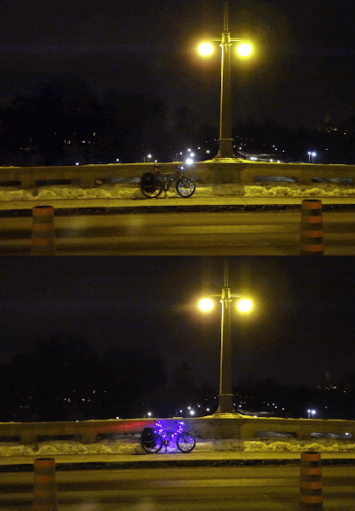
Near the end of December as the Rideau Canal skateway was agonizingly close to opening, I went on a Bike Ride along the canal one night to take some photos of the canal. With my bike resting on one side of the Bank Street bridge, I took a picture of it. Realizing I'd accidentally got it when the flashing purple lights were off, I took another. At the suggestion of a friend, I made it into an animated gif, and it works pretty well!
[Look for more one-photo posts under the label Singles]

[Look for more one-photo posts under the label Singles]
Thursday, January 16, 2014
3D Thursday: Snowbikes
Over at the Kenniston Apartments, which is the name of the retail/apartment complex that contains the Lieutenant's Pump, there are three bike racks used primarily by the residents.
After a mid-December snowfall, they were frozen in time:

I ride a bike in the winter—enthusiastically—but I understand that many people don't. If you're interested in trying, Citizens for Safe Cycling's annual winter family bike ride should be coming up sometime later this month. It's a great way to try with lots of company around, and hot chocolate with marshmallows at the end! Stay tuned to their website and Twitter for details. It's usually a Sunday late-morning in late January.
[Tune in on Thursdays at noon for a new 3D image. View the 3D label for other posts with 3D images. 3D FAQ]
[Look for more one-photo posts under the label Singles]
After a mid-December snowfall, they were frozen in time:


I ride a bike in the winter—enthusiastically—but I understand that many people don't. If you're interested in trying, Citizens for Safe Cycling's annual winter family bike ride should be coming up sometime later this month. It's a great way to try with lots of company around, and hot chocolate with marshmallows at the end! Stay tuned to their website and Twitter for details. It's usually a Sunday late-morning in late January.
[Tune in on Thursdays at noon for a new 3D image. View the 3D label for other posts with 3D images. 3D FAQ]
[Look for more one-photo posts under the label Singles]
Thursday, November 28, 2013
3D Thursday: Nuit Blanche Ottawa Gatineau #nbog13
I took a number of photos during this year's rainy-but-well-attended Nuit Blanche Ottawa+Gatineau on September 21/22, but only two 3D photos. I no longer have two cameras and it's hard to take a pair of stills with moving people in the shot.
Both of the 3D photos I took were in the Market. This tree was nicely done up on George Street, I think by the O-Town [Yarn-]Bombers:

You can see the two exposures by closing one eye, then the other. I think between exposures, a couple of the lights were turned off in the condo building in the background.
With brightly-coloured things like this, the colour shots don't work quite as well because red objects only appear in one eye and blue objects only appear in the other. Here's the same photo again with the colours removed before converting the layers to red and cyan:

The next one is a photographic sculpture by Susy Oliviera at SAW Gallery, called Have Everything and Die. The wall behind was red, so I didn't even bother trying to do the 3D conversion in colour (but I've left the colour in the source photos below).
This sculpture is ideal for photographing in 3D, because a regular photo doesn't capture the essence of it. It's a bunch of pieces of photo moulded together into a kind of sculpture (she had another, photographed on Peter Simpson's Big Beat blog here), but instead of the face put convex (with the nose pointing out), it's concave (with the cheeks and nose going inward):

That's a pretty important part of the piece that you don't get with a regular photo of the sculpture.
But a really neat thing about the 3D photos is if you flip your 3D glasses around (i.e. the red filter on your right eye instead of your left eye), it looks convex! This is a neat twist on the old paper dragon illusion or the rotating mask illusion.
While I'm talking about Nuit Blanche 2013, I should mention that I happened to be in Toronto this October to see Ai Weiwei's Forever Bicycles sculpture, which was installed outside Toronto City Hall for their Nuit Blanche. The colour-changing lighting scheme prevented me from taking any photos in 3D (since I'd need to take two photos in succession), but it's still really neat:

The description says that it's made up of 3,144 bicycles, and the title is a play on the name of China's largest bicycle brand, Yong Jiu, which translates as "forever".

They're not real bicycles, but rather a steel representation of bicycle frames. But the wheels are real bicycle wheels and they all spin freely!

It's possible I'm just imagining it, but from a distance, it looks like the shape of the sculpture is a pair of giant bicycles heading each other off on Nathan Phillips Square:

Truly mesmerising! A shame I couldn't get this shot in 3D!

[Tune in on Thursdays at noon for a new 3D image. View the 3D label for other posts with 3D images. 3D FAQ]
Both of the 3D photos I took were in the Market. This tree was nicely done up on George Street, I think by the O-Town [Yarn-]Bombers:


You can see the two exposures by closing one eye, then the other. I think between exposures, a couple of the lights were turned off in the condo building in the background.
With brightly-coloured things like this, the colour shots don't work quite as well because red objects only appear in one eye and blue objects only appear in the other. Here's the same photo again with the colours removed before converting the layers to red and cyan:

The next one is a photographic sculpture by Susy Oliviera at SAW Gallery, called Have Everything and Die. The wall behind was red, so I didn't even bother trying to do the 3D conversion in colour (but I've left the colour in the source photos below).
This sculpture is ideal for photographing in 3D, because a regular photo doesn't capture the essence of it. It's a bunch of pieces of photo moulded together into a kind of sculpture (she had another, photographed on Peter Simpson's Big Beat blog here), but instead of the face put convex (with the nose pointing out), it's concave (with the cheeks and nose going inward):


That's a pretty important part of the piece that you don't get with a regular photo of the sculpture.
But a really neat thing about the 3D photos is if you flip your 3D glasses around (i.e. the red filter on your right eye instead of your left eye), it looks convex! This is a neat twist on the old paper dragon illusion or the rotating mask illusion.
While I'm talking about Nuit Blanche 2013, I should mention that I happened to be in Toronto this October to see Ai Weiwei's Forever Bicycles sculpture, which was installed outside Toronto City Hall for their Nuit Blanche. The colour-changing lighting scheme prevented me from taking any photos in 3D (since I'd need to take two photos in succession), but it's still really neat:

The description says that it's made up of 3,144 bicycles, and the title is a play on the name of China's largest bicycle brand, Yong Jiu, which translates as "forever".

They're not real bicycles, but rather a steel representation of bicycle frames. But the wheels are real bicycle wheels and they all spin freely!

It's possible I'm just imagining it, but from a distance, it looks like the shape of the sculpture is a pair of giant bicycles heading each other off on Nathan Phillips Square:

Truly mesmerising! A shame I couldn't get this shot in 3D!

[Tune in on Thursdays at noon for a new 3D image. View the 3D label for other posts with 3D images. 3D FAQ]
Thursday, September 19, 2013
3D Thursday: Darkness
Back in mid-May, before the finishing touches were done on the O-Train pathway, I swung by at night and took some photos. I had my tripod with me and some time, so I thought I'd see if I could get the right shots for some 3D photos. I think they turned out pretty well.
This one is of the stairs leading down to Louisa Street off the pathway. The railing had just been installed: (click on the image to see it larger, you can even make out the depth of the blades of grass!)

When you're using one camera to take two exposures for a 3D shot, it's difficult enough in the daytime. The colours or lighting levels don't always match, you need to make sure the subject is stationary, and that the camera location is moved enough to have an effect, but not too much to spoil it. At nighttime, it's even harder. Night photos all but demand a tripod, and my point-and-shoot cameras aren't always consistent in producing the same settings for the same shot.
At the time, they were making rapid progress on installing the ramp in the sidewalk along the Somerset Street viaduct where the pathway comes uphill to meet it, so that cyclists could safely cross the sidewalk. They had left it for the night with the rebar installed and a fence segment laid over it, for safety I guess. This provides a great contrast of depths that works really well in 3D photos.

While I wanted to come back to take a 3D photo the next day, I knew that there was a good chance they'd have poured the concrete, so I went ahead and poked my camera through the construction fence, held it still as best as I could, and took a photo. Then I poked it through the next hole over and did it again. And it turned out pretty good!
As it happened, I had to go by there anyway the next day, and they hadn't yet poured the concrete! But it was a good thing I had taken the photo the night before as I was in a hurry and could only snap a quick photo or two from across the street:

I hope you're enjoying the O-Train pathway, especially now that the O-Train is back in service!
[Tune in on Thursdays at noon for a new 3D image. View the 3D label for other posts with 3D images. 3D FAQ]
This one is of the stairs leading down to Louisa Street off the pathway. The railing had just been installed: (click on the image to see it larger, you can even make out the depth of the blades of grass!)


When you're using one camera to take two exposures for a 3D shot, it's difficult enough in the daytime. The colours or lighting levels don't always match, you need to make sure the subject is stationary, and that the camera location is moved enough to have an effect, but not too much to spoil it. At nighttime, it's even harder. Night photos all but demand a tripod, and my point-and-shoot cameras aren't always consistent in producing the same settings for the same shot.
At the time, they were making rapid progress on installing the ramp in the sidewalk along the Somerset Street viaduct where the pathway comes uphill to meet it, so that cyclists could safely cross the sidewalk. They had left it for the night with the rebar installed and a fence segment laid over it, for safety I guess. This provides a great contrast of depths that works really well in 3D photos.


While I wanted to come back to take a 3D photo the next day, I knew that there was a good chance they'd have poured the concrete, so I went ahead and poked my camera through the construction fence, held it still as best as I could, and took a photo. Then I poked it through the next hole over and did it again. And it turned out pretty good!
As it happened, I had to go by there anyway the next day, and they hadn't yet poured the concrete! But it was a good thing I had taken the photo the night before as I was in a hurry and could only snap a quick photo or two from across the street:

I hope you're enjoying the O-Train pathway, especially now that the O-Train is back in service!
[Tune in on Thursdays at noon for a new 3D image. View the 3D label for other posts with 3D images. 3D FAQ]
Thursday, July 25, 2013
Yellow dots are like loopy buttons for cyclists
(It's been a month since my last post; I'm slowly recovering from a long stint volunteering at RBC Royal Bank Bluesfest where I run the bike parking. This year we had record numbers again!)
A topic I'm eager to write about is the yellow dots on the pavement at intersections. You may recall my epic on pedestrian buttons, No Ifs, Ands or Buttons (and the follow-up supplementary post). Well cyclists have a way of activating the signals too, and what better place to describe it than the brand-new traffic control signal at Bronson and Arlington:

To recap the lowdown on ped buttons: when there is a traffic control signal with buttons, and there is a little yellow sign above the button, that means you must press the button if you want the walk signal to activate (though for some such intersections there might be some times of the day or week when the signal changes on a fixed timing whether or not the button is pressed).
Friday, May 3, 2013
Jane's Walks this weekend!
View other posts on these topics:
Bixi,
Bluesfest,
Bridges,
Bronson,
Carling,
CHP,
Cycling,
Dalhousie,
Elgin,
Nighttime,
Parliamentary Precinct,
Pedestrians,
Plaza Bridge,
Preston,
Rochester,
Somerset,
War Museum,
Winter
In case you haven't heard, Jane's Walk Ottawa happens this weekend. I haven't given any since the Rescue Bronson Jane's Walk I gave two years ago. It was fun, but a lot of work. So instead I'll try to go out on a couple of other people's walks. Here are some I'm looking at that are within Somerset Ward, with the description on the Jane's Walk Ottawa website linked to the headings:
Apt613 Blog Walk of Somerset
Saturday, May 4, 2013, 2pm-3:30pm
Meet at Dundonald Park, Somerset and Bay
Staying on the Bronson theme of my 2011 walk, Apartment 613 is holding a walk in Chinatown, whose businesses are suffering from the closure of the Bronson/Somerset intersection. This one has a neat format, where they'll interview some of the business owners in the same way they do interviews for their blog entries, only it'll be live and you'll be there!

Local Confectionaries
Saturday, May 4, 2013, 4pm-5pm
Meet at Somerset and Preston
A great segue from the Apt613 walk, local cartoonist/illustrator Colin White is giving a tour of the corner stores which feature often in his drawings. I don't think I've met him in person, but I like his depictions of familiar hyperlocal landmarks.
Monday, April 15, 2013
Bixi's back for 2013
As of today, Capital Bixi is back in action! For subscribers like me, that means my key should work for the remainder of my one-year subscription (which I bought last June). And for you readers of my blog, that means I'm going to blog about it!

I never got around to blogging my Bixi photos last year (and the year before, my season-opener blog post used photos from the 2009 pilot), so I get to include some of those with this post. For example, the one above was taken last June at the Museum of Nature's east lawn, at Elgin and McLeod. On Saturday night, the bikes had been re-installed, though it was decidedly snowier:

I never got around to blogging my Bixi photos last year (and the year before, my season-opener blog post used photos from the 2009 pilot), so I get to include some of those with this post. For example, the one above was taken last June at the Museum of Nature's east lawn, at Elgin and McLeod. On Saturday night, the bikes had been re-installed, though it was decidedly snowier:
Tuesday, March 5, 2013
Winter cycling, Ottawa, 2013
Even though Citizens for Safe Cycling's 2nd Ottawa Family Winter Bike Ride was over a month ago, I got some photos at unique angles that are worth sharing. Plus, you know, we're still cycling and (despite all protests) it's still Winter.
One of the neat photos I got was this one, from the second floor of City Hall. Get a load of the shadow on that bike at the bottom:

Here's another shot, of CfSC President Hans Moor giving a pre-ride pep talk to the group. He had his own writeup on the ride, which includes a photo of yours truly. That thing on my pant pocket in his photo is the tripod I used to get this high-angle shot:

I went ahead of the group on Laurier to get some shots of the group approaching. People were dismounting to cross the barricade because the snowbank had not been cleared in the opening at Percy to allow a left turn. Cars in both directions waited very patiently for the cyclists to cross.

On another note, there is a public open house tonight to reveal the City's plans for Albert Street through LeBreton Flats. This will (hopefully) show the outcome of the pedestrian report devised from the walkabout in October. It is at 7-9pm at the Dalhousie Community Centre, room 31. As far as I understand, it's a drop-in type event so you don't have to come for the whole duration.
Wednesday, September 5, 2012
Peds on Weds: No; more ifs, ands, or buttons
View other posts on these topics:
Booth St,
Bronson,
Congress Centre,
Cycling,
Gladstone,
LeBreton Flats,
Needs Repair,
Pedestrians,
Portage Bridge,
Sandy Hill/Market,
Sidewalks,
Wellington
Back in May I had a lengthy blog post titled No ifs, ands or buttons which described in detail how terribly complicated pedestrian buttons are in a road environment that is designed for cars.
Since that post, I noticed a few more situations I omitted about pedestrian buttons. These examples are all at the edge of Centretown or just outside it.
Outside the fancy new Ottawa Convention Centre at Colonel By Drive and Daly on the other side of the Rideau Canal, some of the concrete pavers are lined up with grooves in the middle. This is an accessibility feature so that the visually impaired can safely direct themselves to the crosswalk safely, and stop before getting to the edge. The grooves in poured concrete sidewalks perform the same function (and most streets that have precast pavers for sidewalks will use a concrete pad at the intersection to provide these accessibility features). Can you see the problem?
 The groove takes you to the centre of the crosswalk, but the buttons you need to press to activate the pedestrian signal are at the edges of the crosswalk. And this crosswalk is so wide that the button on the right side didn't even fit into the shot.
But at least at that intersection, the button is necessary for anyone to use the crosswalk—not just the visually impaired—so at least there's someone else there to activate the crossing signal. As mentioned in the May entry, this is discernible by the sign above the button on the pole. If our blind pedestrian is lucky, the sighted pedestrian will press the button for three or more seconds, activating the audible signal, instead of just the quick press required to request the crossing.
Monday, September 3, 2012
Centretown time capsule: August/September 2007
Happy Labour Day everyone!
For today's post, I want to do something a little different. I wanted to give a snapshot of what was happening in Centretown five years ago in August and September 2007. With a high proportion of renters, many Centretown residents—even those active in community affairs—weren't here five years ago (nor was this blog!). For the rest of us, it'll be a trip down memory lane.
The 2007 Labour Day parade, organized by the Ottawa and District Labour Council, ended as usual at McNabb Park for the annual festival with free hotdogs, corn on the cob, and other attractions (if you're reading this post shortly after it goes up, head out there now! They should be there from the end of the parade until 4:30pm). You might recognize this photo of the wading pool as one of the four at the bottom of the CCCA's 'promo cards':
 September 2007 marked the official opening of the Corktown Footbridge on the 11th (the bridge opened to traffic the previous September). Municipal politicians and interpreters in 1830's period dress were there to cut the ribbon.
Wednesday, July 11, 2012
Seeing green (#ottbike box Bay/Wellington)
View other posts on these topics:
Bay,
Cycling,
NCC,
Roads,
Wellington
Sorry for the lack of blog posts; I've been spending all my time and energy on the Bluesfest bike parking, which is Citizens for Safe Cycling's biggest fundraiser of the year. (By the way, we have not filled up yet, and the 'lineups' at the end of the night are rare, five minutes tops, so ride your bike and leave it securely with us!)
On my way back last night from the Blesfest office at 2:30am, I saw the City crews installing the thermoplastic green coating for the bike box at Bay and Wellington. This helps cyclists turn left, and avoids cyclists getting the 'right hook' from right-turning motorists. The thick plastic surface—the same stuff used in the intersections along the Laurier bike lanes—is melted on with torches and is pretty resilient. You can seee the workers melting on the final touches at the far end of the lane here, just in time for the one-year anniversary of the Laurier Segregated Bicycle Lane!
 I chatted with the guy who was responsible for finalizing the design of the bike box. He also worked on the Laurier bike lanes and is working on the lane configuration for Rideau Street.
The bike box is to connect to the new segregated bicycle lane along Wellington street, which in turn connets to the pre-existing segregated bike lane on the NCC's Portage Bridge.
That whole intersection was completely redone in the last couple of months, adding crosswalks and bike lanes to the previously pedestrian-free intersection (pedestrians and bikes were expected to navigate a confusing route of paths and tunnels under the various corners of Wellington Street).
When you get to the Wellington/Portage intersection westbound, there's another new road device: since cyclists coming from Hull/Gatineau off the Portage bridge are on the wrong side of the street, they'll have to get to the south side of Wellington. This little drop-off area lets them pull away from the northbound cyclists and dismount to cross the intersection. Northbound cyclists (in the direction from which this photo was taken) can also dismount:
 Dismounting is required because the Ontario Highway Traffic Act (rightly) prohibits cycling in the crosswalk. The City's cycling department wanted to install a "cross-ride" here—essentially a channel alongside the crosswalk in which you can cycle—but since the provincial law doesn't have provisions for such a facility, they couldn't. (psst: Ottawa—Centre's MPP is Yasir Naqvi, I'm sure he'll love to hear from you!)
Until it is, you'll have to get off your bike and walk. The paths and tunnels that weave under the intersection are unchanged, and still very much useable if you'd rather stay out of the intersection.
The next "missing link" in the cycling network on the City's list is the jog in the east-west Byron-Gladstone cycling route at Tyndall between Parkdale and Holland. Not in Centretown, or even in Somerset ward, but you're probably interested nonetheless.
Alright, back to Bluesfest for me! Once the festival's over, I'll have to get back through my considerable backlog in sorting my photos! Blogging will continue to be sporadic until the end of the month.
Monday, July 2, 2012
Capital Day
While we're still coming off yesterday's Canada Day high, I figured a photo of Capital symbols was appropriate for today.
I was over at the War Museum the other day having a look at the set up for Bluesfest and CfSC's free Bluesfest bike parking compounds when this photo opportunity presented itself:
 Three symbols of Canada's capital, the Canadian War Museum, a Capital Bixi bike share station, and an OC Transpo bus.
The fenced field area in the foreground is one of the two bike parking compounds I'll be in charge of during this year's Bluesfest. It's free, and anyone can use it, whether you're a Bluesfest patron, volunteer, or not even coming to see Bluesfest!
In addition to the bike parking service, we'll have lots of free safety information available, as well as maps and lights for sale. More information on the Citizens for Safe Cycling website.
[Look for more one-photo posts under the label Singles]
Monday, April 30, 2012
Somerset Street Reconstruction Part 13: O-Train Pathway — Cantilevered Boardwalk
View other posts on these topics:
Construction,
Cycling,
Dalhousie,
O-Train,
Pathways,
Pedestrians,
Roads,
Somerset,
Utilities,
Vehicles
This is part 13 in the 15-part series on last year's reconstruction of Somerset Street West. Last time, I showed the construction of the tunnel that was built under the Somerset Street viaduct for the O-Train pathway.
In order to retain pedestrian connectivity while Somerset was completely dug up, a temporary boardwalk was installed off the side of the viaduct.
The bridge's railings were temporarily removed to provide access. You can see the oval-shaped railings sitting on the sidewalk here, with some connecting pieces standing on their ends in a couple of piles:
 The mere removal of the railings—in another context—was a significant behind-the-scenes controversy in its own right, which I'll cover in the next post in the series.
While the boardwalk was being prepared, and before the hole was excavated, pedestrians crossing the bridge were directed by two rows of fencing to the middle of the roadway, which was closed to cars.
Friday, April 27, 2012
Somerset Street Reconstruction Part 12: Buliding the O-Train Pathway Tunnel
View other posts on these topics:
City Centre,
Construction,
Cycling,
Dalhousie,
O-Train,
Pathways,
Pedestrians,
Roads,
Somerset,
Vehicles
This is part 12 in the 15-part series on last year's reconstruction of Somerset Street West. In the previous post I described the planning behind the pathway that will go along the O-Train corridor (to be called the Champagne Pathway, I've just learned). Today I'll show the construction of the tunnel that had to be installed under Somerset to make this pathway happen. Eric Darwin of West Side Action blogged frequently during this construction process and I've included links to his relevant posts at the appropriate points.


Monday, April 16, 2012
Somerset Street Reconstruction Part 11: Planning the O-Train Pathway
View other posts on these topics:
City Centre,
Cycling,
Dalhousie,
O-Train,
Pathways,
Pedestrians,
Planning and Development,
Somerset
In the previous part of the 15-part series on the reconstruction of Somerset Street West, we looked at the City Centre complex, shown here with one of the many piles of garbage scattered behind the building.
 The City Centre's connection to the Somerset Street reconstruction has to do with the tunnel built under Somerset last year, which will connect a new pathway in an existing corridor between the City Centre building and the O-Train tracks. Here's that corridor from the Somerset Street bridge, looking North to Albert and Bayview station.
 The City Centre's connection to the Somerset Street reconstruction has to do with the tunnel built under Somerset last year, which will connect a new pathway in an existing corridor between the City Centre building and the O-Train tracks. Here's that corridor from the Somerset Street bridge, looking North to Albert and Bayview station.
Friday, March 23, 2012
Somerset Street Reconstruction Part 7: Trees & bike racks
View other posts on these topics:
Chinatown,
Construction,
Cycling,
Dalhousie,
Hintonburg,
Preston,
Roads,
Sidewalks,
Somerset,
Trees
We've had some very summer-like weather the last few days, and the bike counter on the Laurier segregated bike lane registered 1519 cyclists on Wednesday, 2/3 of the highest daily number ever counted at that location!
That makes a good opportunity to talk about the trees and bike racks in this installment of the 15-part series on the reconstruction of Somerset Street West. Previously, in part 6 the subject was poles and signals.
 In the seventeen meetings of the design committee, great persistence by the community representatives and creative thinking all around enabled many more trees to be fit into the design. A particular challenge was getting trees on the viaduct/bridges by the City Centre building, because the drainage patterns make a challenging environment for trees' chance of survival. The solution is described in the next post in the series, part 8*, but this preliminary diagram gives an idea of how many more new trees (the dark green circles) will be added to join the old ones (lighter green circles):
Subscribe to:
Posts (Atom)