This Wednesday, November 21, 2012, the Centretown Citizens Community Association is holding its Annual General Meeting at McNabb Community Centre. In addition to the regular business of the association's members, such as electing directors to the Board, there will be presentations about issues affecting Centretown.
Back in May, the CCCA held a meeting, also at McNabb, to bring attention to the Centretown Community Design Plan. The meeting was very well attended by Centretown residents, many of whom hadn't heard of the CDP before the meeting.
The plan was already a year overdue in May and is still. After the City recently released a "final draft" of the plan a few years into the process, the development industry produced a lenghty document with line-by-line edits they want made to the plan. An update will be provided at the AGM on this recent development (pardon the pun) which will yet again postpone the plan going to Planning Committee for approval by City Council.
There will also be two presentations at Wednesday's meeting: "Achieving Results for Communities at City Hall," by Christopher Collmorgan, President of our neighbour association, Action Sandy Hill; and "Development — Yes! Lifeless Streetscapes — No!" by Paul Kariouk, Centretown resident and Associate Professor of Architecture at Carleton University.
The agenda and reports are available on the CCCA website (permalink), and the flyer contains bios of the two keynote presenters.
You can become a CCCA member (so long as you're from the area bounded by Bronson, the 417, the Ottawa River and the 417) at the meeting for only $5 per year, or if you can't make it you can also join and/or donate online. Your participation of time or money is what keeps the CCCA going as a voice for residents at City Hall on decisions affecting Centretown, and will also help us finance what promises to be an expensive OMB appeal of City Council's decision to rezone 96 Nepean Street for a 27 storey tower (I discussed that project and its context in this lengthy post.
At the meeting on Wednesday, you can also put your name forward for one of the eight positions (6 for two years, 2 for one year) on the Board of Directors for the election. As it happens, I am chairing the Nominations Committee, whose report is at the end of the longform agenda (a briefer one will be in hard copy at the meeting), so you can contact me (centretown dot ottawa at gmail dot com) if you would like to put your name forward or if you want more information. As you can read in the report, there is a shortage of candidates in the area west of Elgin and north of Somerset, and there are so far only 7 candidates. The Board members elected at the AGM will join those of us in the second year of our terms and from this group will be selected the Executive members: Vice-President, Corporate Secretary, Membership Secretary and Treasurer.
See you on Wednesday!
PS: Bronson Avenue should partially re-open to traffic tonight or tomorrow, one lane in each direction from Gladstone south. Ongoing work in the intersection at Somerset means a the section from Gladstone to Somerset won't reopen to through traffic for some months yet. Somerset to Laurier will fully close for construction some time next year.
Showing posts with label Zoning. Show all posts
Monday, November 19, 2012
Annual Centretown meeting on Wednesday
View other posts on these topics:
CCCA,
McNabb,
Planning and Development,
Zoning
Friday, May 25, 2012
CCCA News & Events May 2012
View other posts on these topics:
CCCA,
Minto Park,
Planning and Development,
Zoning
The following message was recently sent to the e-mail list of the Centretown Citizens Community Association by CCCA President Jordan Charbonneau. I've added the photos to this version. Join the CCCA, follow @CentretownCCA on Twitter, and get on the e-mail list to receive 2-3 updates per month from the CCCA. Note that Images of Centretown is my personal blog and not a blog of the CCCA.
Good evening,
I've outlined below some of the events and initiatives of note in Centretown. More information on upcoming events is available on the CCCA website, which I encourage you to check often.Centretown Community Design Plan Meeting: This is certainly the biggest CCCA-sponsored event so far this year, and probably for the last few years! Members of the CCCA, in particular Joan Spice and Judy Forrest, have been working extremely hard to prepare for this meeting on 30 May 2012, which is intended to inform and engage Centretown residents regarding the soon-to-be-finalized Centretown Community Design Plan. George Dark, the consultant who led the creation of the plan, and several CCCA and City figures will be in attendance and presenting on the plan. See the attached poster for more information (which I encourage you to print and post around the community or send electronically to your networks) and come out to the meeting to take part in the discussion of this extremely important document!
Minto Park Sale: While the community design plan meeting is our main focus at the moment, don't forget that Councilor Diane Holmes' annual Minto Park Sale will take place from 8 a.m. to 2 p.m. on Saturday, 16 June 2012 in Minto Park! If you're interested in participating, send an email with your home address and a contact phone number to MintoParkSale@ottawa.ca ($10 per table rented). The event will include a CCCA BBQ, bake sale, plant sale and electronic waste collection service (see the Recycle Your Electronics website for exactly what we can take as part of this service. Note that it does not include light bulbs or things like toasters). I have attached the poster for this event; feel free to distribute it as well!
Volunteer Opportunities:
Heritage Conservation District Study: A reminder that, this summer, Heritage Ottawa is helping conduct a study of heritage conservation districts (HCD) in four Ottawa neighbourhoods: Rockcliffe Park, New Edinburgh, Lowertown and Centretown. In order to pull it off, however, they need volunteers! There will be a two-hour training session in the evening of Monday, 4 June 2012, and conducting the survey itself takes just a few hours. If you're interested, please respond to this email by next Tuesday, 22 May 2012.Buzz Deliverer: Don't forget that the Centretown Buzz newspaper is always looking for volunteers to help with delivery. In particular, they need individuals with a vehicle to make some of the larger deliveries (gas reimbursement negotiable). Let me know if you're interested, or if you'd like more information.
Transportation Committee Chair: We are currently looking for a chair for our Transportation Committee. If you have an interest in transportation-related issues (and that's pretty broad!), let me know. The committee usually meets once a month to review and discuss transportation developments, but the role could be yours to shape! Many thanks to Robert Dekker, CCCA vice-president and co-chair of the Planning and Development Review Committee, for his excellent work in this role.For more information on the CCCA, including its meetings, see our website.
Have a great long weekend!
Wednesday, May 25, 2011
The Bell Machine
View other posts on these topics:
Elgin,
Planning and Development,
Singles,
Zoning
As a cyclist, I'd never had a reason to enter the parkade at Place Bell (160 Elgin) until recently. Even though its 10 floors are shorter than a regular one (since it's just exposed concrete), it's still dwarfed by the 27-storey Place Bell. This is looking from the roof of the parkade to the top of Place Bell.
In addition to learning the parkade's height, I also discovered that the parkade is square. If I understand correctly, they needed to build it above-ground because of the soft soil underneath the site.
Claridge is building four more towers of the same height next door to this parkade--two across Nepean as part of the 187 Metcalfe development (the one that Council sped through the approvals on the promise of a portrait gallery--since changed to a grocery store), and two more at 89-91 Nepean. 70 Gloucester, the twin of 89-91 Nepean, went to Planning Committee on Tuesday.
When the Centretown Plan was developed, it went up to Gloucester Street, except for a notch to exclude Place Bell due to its obvious incongruence with the neighbourhood. It's a shame, then, that Claridge got away with using 1960s buildings to justify heights far above those in the development plans for the neighbourhood.
[Look for more one-photo posts under the label Singles]
Claridge is building four more towers of the same height next door to this parkade--two across Nepean as part of the 187 Metcalfe development (the one that Council sped through the approvals on the promise of a portrait gallery--since changed to a grocery store), and two more at 89-91 Nepean. 70 Gloucester, the twin of 89-91 Nepean, went to Planning Committee on Tuesday.
When the Centretown Plan was developed, it went up to Gloucester Street, except for a notch to exclude Place Bell due to its obvious incongruence with the neighbourhood. It's a shame, then, that Claridge got away with using 1960s buildings to justify heights far above those in the development plans for the neighbourhood.
[Look for more one-photo posts under the label Singles]
Wednesday, March 23, 2011
Upcoming meetings and events in Centretown - including tonight!
View other posts on these topics:
CCCA,
Gloucester,
Lyon,
Minto Park,
Planning and Development,
Transit,
Zoning
The following message was sent to the e-mail list of the Centretown Citizens Community Association early this morning. Join the CCCA and get on the e-mail list to receive 2-3 updates per month from the CCCA. Note that Images of Centretown is my personal blog and not a blog of the CCCA.

Dear CCCA members and followers,
There are some important meetings coming up in the next couple of weeks:
Tonight, Wednesday, March 23, 7-9pm
Public meeting on 224 Lyon (at Gloucester) development
7pm, Ottawa City Hall, 110 Laurier (Richmond Room)
The CCCA has already submitted comments lauding many positive aspects of the plan, but asking that the height and setback limits not be increased. The CCCA has also asked that mature trees removed for this development be replaced by more trees (on site or elsewhere), asking for visitor parking to be included, and asking that, if the City grants the height increase, that it seek a Section 37 agreement for the increased density.
The City of Ottawa has more information on this proposal here:
http://app01.ottawa.ca/postingplans/appDetails.jsf?lang=en&appId=__7FKLD1

Other rezoning applications
Dear CCCA members and followers,
There are some important meetings coming up in the next couple of weeks:
Tonight, Wednesday, March 23, 7-9pm
Public meeting on 224 Lyon (at Gloucester) development
7pm, Ottawa City Hall, 110 Laurier (Richmond Room)
The CCCA has already submitted comments lauding many positive aspects of the plan, but asking that the height and setback limits not be increased. The CCCA has also asked that mature trees removed for this development be replaced by more trees (on site or elsewhere), asking for visitor parking to be included, and asking that, if the City grants the height increase, that it seek a Section 37 agreement for the increased density.
The City of Ottawa has more information on this proposal here:
http://app01.ottawa.ca/

Other rezoning applications
Wednesday, March 2, 2011
Centretown updates for March 2011
View other posts on these topics:
CCCA,
Museum of Nature,
Planning and Development,
Zoning
The following message was sent to the e-mail list of the Centretown Citizens Community Association early this morning. Join the CCCA and get on the e-mail list to receive 2-3 updates per month from the CCCA. Note that Images of Centretown is my personal blog and not a blog of the CCCA.

Dear CCCA members and followers,
Here are some dates to mark on your calendars for upcoming meetings and events in Centretown:
Dear CCCA members and followers,
Here are some dates to mark on your calendars for upcoming meetings and events in Centretown:
Monday, February 21, 2011
Tuesday at City Hall: Tower on a postage stamp
View other posts on these topics:
CCCA,
Nepean St,
Planning and Development,
Zoning
On Tuesday morning, the City of Ottawa's Planning Committee will be Considering an application for a 27-storey tower on Nepean Street, on a tiny site the size of a postage stamp. I had hoped to write this up much sooner, but better late than never...
Back in December 2010, FoTenn consultants came to the Centretown Citizens Community Association's Planning & Development Review Committee to seek community input on a 27-storey building their client, Claridge, wants to build at 89-91 Nepean Street. Here's a map of the site:
That map is based on the map (PDF) in the Centretown Secondary Plan. The white area at the top is the Central Business District, outside Centretown. The pink area is the "mid-rise" zone, which was envisioned to max out at about 9 storeys. The brown area where this site sits is supposed to be a "transition zone" between the central area (which generally has tall buildings), and the mid-rise area to the south.
Here's 89 and 91 Nepean Street, looking North-Westish (assuming Nepean runs East-West on Ottawa's skewed grid), in April 2010. The grassy lot is 89 Nepean, and there is a gravel parking lot at 91 Nepean next to it. They're pretty small sites. One of them has a "for sale" sign, though I can't tell for sure which:
Back in December 2010, FoTenn consultants came to the Centretown Citizens Community Association's Planning & Development Review Committee to seek community input on a 27-storey building their client, Claridge, wants to build at 89-91 Nepean Street. Here's a map of the site:
That map is based on the map (PDF) in the Centretown Secondary Plan. The white area at the top is the Central Business District, outside Centretown. The pink area is the "mid-rise" zone, which was envisioned to max out at about 9 storeys. The brown area where this site sits is supposed to be a "transition zone" between the central area (which generally has tall buildings), and the mid-rise area to the south.Here's 89 and 91 Nepean Street, looking North-Westish (assuming Nepean runs East-West on Ottawa's skewed grid), in April 2010. The grassy lot is 89 Nepean, and there is a gravel parking lot at 91 Nepean next to it. They're pretty small sites. One of them has a "for sale" sign, though I can't tell for sure which:
Friday, June 4, 2010
June's another busy month in Centretown
View other posts on these topics:
CCCA,
City Hall,
Cycling,
DCA,
Minto Park,
Planning and Development,
Roads,
Traffic,
Yellow House,
Zoning
I thought that last month had a lot going on, but this month is even busier!
First up, I was in the Ottawa Sun and on the cover of its free commuter daily affiliate, 24 Hours today. The topic of discussion was the yellow house on Gladstone, which I previously blogged about here, and the Bay & Nepean site, which I blogged about here.
There's also Doors Open Ottawa this weekend. For the armchair tourist, check out some of the sites (and others) that I've blogged under the "Tours label"
Next week there are a gazilion and a half meetings, including:
Bronson Consultation:
DCA President Eric Darwin has a series of posts going up on West Side Action regarding the reconstruction of Bronson Avenue. He and I are both on the Public Advisory Committee, whose goal is to shape the vision of Bronson post-redevelopment. I blogged about that previously here.
Many of us on the PAC aren't satisfied with the level of consultation and want to hold our own consultations and talks. We've secured a table-sized printout of the existing conditions on Bronson, and we'll be meeting sometime next week (TBD) to discuss opportunities, prior to the next PAC meeting on the 15th (which is for PAC members only, unfortunately). Contact me at centretown.ottawa -at- gmail - dot- com if you're interested or if you have feedback.
Mid-Centretown Community Design Plan
The CCCA's Planning & Development Review Committee is taking a pro-active role in providing input to the consultation for the Mid-Centretown Community Design Plan. The consulting team will be holding an open house next Tuesday, June 8th from 5:30 to 7pm at Woodside Hall in Dominion-Chalmers United Church on Lisgar/Cooper/O'Connor.
This is an important planning document that will set guidelines for Mid-Centretown (Elgin-Kent, Gloucester to the 417) as development in that corridor picks up pace, giving it a coordinated shape that makes sense.
The consulting team have developed a blog on the project at midcentretown.wordpress.com
Segregated Bicycle Lanes
The Segregated Bicycle Lane pilot study, which I previously summarized here and whose website is at www.ottawa.ca/bikelane, is having four open houses in the next couple weeks:
June 7 – Dalhousie Community Centre, Somerset at Empress (6:30-8:30)
June 8 – McNabb Community Centre, Percy at Gladstone/James/Florence (6:30-8:30)
June 10 – Dominion-Chalmers United Church, Lisgar/O'Connor/Cooper (6:30-8:30)
June 14 – City Hall (5-7)
Minto Park Sale and CCCA BBQ
Councillor Holmes is again hosting the Minto Park Sale, a yard sale for those of us without yards, on Saturday, June 12, 9am-3pm in Minto Park (Elgin at Gilmour/Lewis). Book a table for $10 at mintoparksale@ottawa.ca . The CCCA's Trees & Greenspace Committee will be holding its annual plant sale at the event.
The CCCA will also be hosting a fundraiser BBQ like last year, with yours truly at the grill. We'll be serving all-beef hotdogs and veggie dogs, plus soft drinks, and a water station to refill your water bottle, and we'll also be selling CCCA memberships. Funds raised by the BBQ will be split among the CCCA and the Minto Park Sale's beneficiary for 2010, the Well at St. John the Evangelist Church. Note: We're still trying to locate a decent-sized barbecue to borrow from someone near Minto Park. Contact me if you can help (we have one that we can borrow but it may not be big enough)
This is our second-biggest fundraiser of the year, so please come by and grab a dog and support your local community association!
Monthly CCCA meeting
The monthly meeting of the Centretown Citizens Community Association is on the third Tuesday of the month, as always, at City Hall at 7pm (Honeywell Room). The guest this month will be mayoral candidate Alex Cullen.
This follows the previous day's meeting of the CCCA's Planning & Development Review Committee, which meets on the second Monday of the month at 5:30, usually at the Second Cup on Elgin at Lisgar (though we may be migrating to a reserved room at City Hall).
Cycling blogs
The Ottawa Sun has a new cycling-related blog called the SpokesMan, at blogs.canoe.ca/spokesman, by Kris Westwood.
There's also the new-to-me blog, and new on the Blogawa feed, The Incidental Cyclist, by Kate and her bike, Mike. Kate talks a lot about issues pertaining to people who cycle for transportation.
Carling Avenue reconstruction
Carling Avenue is being reconstructed between the O-Train tracks and Bronson Avenue. There will be an open house on the project on Tuesday, June 22, 2010 from 7-8pm at the Dow's Lake Pavillion, Vista Room.
All of these events are open to the public, there are a few other things going on this month that aren't that I haven't listed here, but some of which I'll be able to blog about as they happen.
Again, remember that your local community associations participate in all of these events. Please support them by coming out to meetings and events, becoming a member, and donating generously!
First up, I was in the Ottawa Sun and on the cover of its free commuter daily affiliate, 24 Hours today. The topic of discussion was the yellow house on Gladstone, which I previously blogged about here, and the Bay & Nepean site, which I blogged about here.
There's also Doors Open Ottawa this weekend. For the armchair tourist, check out some of the sites (and others) that I've blogged under the "Tours label"
Next week there are a gazilion and a half meetings, including:
Bronson Consultation:
DCA President Eric Darwin has a series of posts going up on West Side Action regarding the reconstruction of Bronson Avenue. He and I are both on the Public Advisory Committee, whose goal is to shape the vision of Bronson post-redevelopment. I blogged about that previously here.
Many of us on the PAC aren't satisfied with the level of consultation and want to hold our own consultations and talks. We've secured a table-sized printout of the existing conditions on Bronson, and we'll be meeting sometime next week (TBD) to discuss opportunities, prior to the next PAC meeting on the 15th (which is for PAC members only, unfortunately). Contact me at centretown.ottawa -at- gmail - dot- com if you're interested or if you have feedback.
Mid-Centretown Community Design Plan
The CCCA's Planning & Development Review Committee is taking a pro-active role in providing input to the consultation for the Mid-Centretown Community Design Plan. The consulting team will be holding an open house next Tuesday, June 8th from 5:30 to 7pm at Woodside Hall in Dominion-Chalmers United Church on Lisgar/Cooper/O'Connor.
This is an important planning document that will set guidelines for Mid-Centretown (Elgin-Kent, Gloucester to the 417) as development in that corridor picks up pace, giving it a coordinated shape that makes sense.
The consulting team have developed a blog on the project at midcentretown.wordpress.com
Segregated Bicycle Lanes
The Segregated Bicycle Lane pilot study, which I previously summarized here and whose website is at www.ottawa.ca/bikelane, is having four open houses in the next couple weeks:
June 7 – Dalhousie Community Centre, Somerset at Empress (6:30-8:30)
June 8 – McNabb Community Centre, Percy at Gladstone/James/Florence (6:30-8:30)
June 10 – Dominion-Chalmers United Church, Lisgar/O'Connor/Cooper (6:30-8:30)
June 14 – City Hall (5-7)
Minto Park Sale and CCCA BBQ
Councillor Holmes is again hosting the Minto Park Sale, a yard sale for those of us without yards, on Saturday, June 12, 9am-3pm in Minto Park (Elgin at Gilmour/Lewis). Book a table for $10 at mintoparksale@ottawa.ca . The CCCA's Trees & Greenspace Committee will be holding its annual plant sale at the event.
The CCCA will also be hosting a fundraiser BBQ like last year, with yours truly at the grill. We'll be serving all-beef hotdogs and veggie dogs, plus soft drinks, and a water station to refill your water bottle, and we'll also be selling CCCA memberships. Funds raised by the BBQ will be split among the CCCA and the Minto Park Sale's beneficiary for 2010, the Well at St. John the Evangelist Church. Note: We're still trying to locate a decent-sized barbecue to borrow from someone near Minto Park. Contact me if you can help (we have one that we can borrow but it may not be big enough)
This is our second-biggest fundraiser of the year, so please come by and grab a dog and support your local community association!
Monthly CCCA meeting
The monthly meeting of the Centretown Citizens Community Association is on the third Tuesday of the month, as always, at City Hall at 7pm (Honeywell Room). The guest this month will be mayoral candidate Alex Cullen.
This follows the previous day's meeting of the CCCA's Planning & Development Review Committee, which meets on the second Monday of the month at 5:30, usually at the Second Cup on Elgin at Lisgar (though we may be migrating to a reserved room at City Hall).
Cycling blogs
The Ottawa Sun has a new cycling-related blog called the SpokesMan, at blogs.canoe.ca/spokesman, by Kris Westwood.
There's also the new-to-me blog, and new on the Blogawa feed, The Incidental Cyclist, by Kate and her bike, Mike. Kate talks a lot about issues pertaining to people who cycle for transportation.
Carling Avenue reconstruction
Carling Avenue is being reconstructed between the O-Train tracks and Bronson Avenue. There will be an open house on the project on Tuesday, June 22, 2010 from 7-8pm at the Dow's Lake Pavillion, Vista Room.
All of these events are open to the public, there are a few other things going on this month that aren't that I haven't listed here, but some of which I'll be able to blog about as they happen.
Again, remember that your local community associations participate in all of these events. Please support them by coming out to meetings and events, becoming a member, and donating generously!
Sunday, March 21, 2010
Bay and Nepean demo, Intro and Part 1 of 6: 249-251 Bay Street
View other posts on these topics:
Bay,
CCCA,
Demolition,
Nepean St,
Planning and Development,
Tours,
Zoning
Back in December, I was interviewed by the CBC to talk on behalf of the CCCA about the long-abandoned houses around Bay and Nepean Streets. The houses were bought years ago by the developer Richcraft, who had posted large billboards advertising the condo development to be built there.
There were a few problems with this project. While they did get many successive increases in height for the site, the owners of the buildings on the corners would not sell. The resulting T-shaped site made it difficult to build a particularly substantial building, so the plans never went very far.
Meanwhile, the houses were left virtually abandoned. They were certainly unused, as the project went from being very soon to not in the foreseeable future. As they were unused, they became decrepit, attracting graffiti taggers, vandals and break-ins. Really, these houses should not have been emptied of tenants so swiftly, as (legal) occupants would have allowed them to be kept in decent shape. Instead, we're left with tinder boxes that are falling apart.
Richcraft even applied for a demolition permit for the houses, but when you get such a permit, you are required to build a replacement building within five years. This deters people from demolishing the houses that define our neighbourhoods and leaving our neighbourhoods filled with empty lots and parking lots. Because of this clause, they refused to sign off on the permit (thus accepting its five-year limit) and instead have left the houses to fall apart, threatening the neighbouring buildings.
Finally, in mid-December when the City threatened to replace these unsafe houses with landscaping and bill the property owner, Richcraft applied for another permit, asking for an eight-year timeframe to rebuild, which was approved.
The houses were demolished last week.
As with the Bank Street reconstruction, I've broken this topic into a series of posts. After much wrangling with the photo set, I settled on breaking it up on one post per house, plus a sixth post later in the year once the work is done. The list below will be updated as the entries are posted, every four days:
Here is how the East side of Bay Street looked from Nepean to Gloucester in mid-November 2008, shortly after the installation of the speed humps on Bay Street (part of the Centretown Traffic Calming plan). Indeed, it would have looked pretty similar until last week as far as the structures are concerned. At the corner of Bay and Nepean is Ricardo's Pizza, which I hear makes very good pizza.
Last Thursday, it was certainly a bit emptier, with demolition progressing.

The building we'll be looking at today is the one furthest from the camera in the above photos. With the address 249-251 Bay Street, this building housed a Bed & Breakfast known as The Bay Guest House. In this photo from late May 2009, it looks more or less as it did for many years, except for more graffiti and fewer stairs. There are even patio tables still on the second-floor balcony.
And on Thursday morning, most of it was gone.
Even much of the graffiti is years-old, as seen in this photo from late November 2007. There's a piece of flashing on the cornice that was falling off, and less graffiti on the building and the "Lifestyle Condos coming soon!" sign, but more or less the same. The "Bayscorner" corner store, which has a faded painted sign from its former life as a drug store, is not being demolished, but someone must have forgotten to tell the graffiti taggers.

Again, it is demolished. You can make out some of the distinguishing porch features in the rubble. The couple portrayed on the sign are still grasped in each other's arms.
Here's a closer shot of the porch from late May 2009. The weeds in the planter boxes were a nice, if unintended, touch. You can also see three pink sheets on the boarded-up front door. These are notices from the City posted after some of the rear porches were removed from some of the buildings without a permit to do so.
And rubble. One of the columns still stands, marking the address of the former building, and a patio table lies atop the rubble. You can make out the top of one of the Hudson Park buildings in the background.
Here's a closeup of the top of one of the columns, plus the brick detail under the cornice.
Here's the same column, fallen. I had originally thought of breaking up these posts chronologically instead of by site, but I figured this way gives better context. Besides, the photos of the buildings are the main point; following them with a post full of photos of debris would be pretty dry.
At the back of the Bay Guest House there used to be an addition, shown here in late November 2007.
This rear addition was demolished in late May 2009, without a permit (hence the pink notices on the front door)
Here you can see a bunch of graffiti along the side of the house, again in late May 2009. Near the back of the side wall, a couple bricks were drilled out of the wall, with the brick dust covering the former driveway.
Here's a closeup of that gap in the bricks. You can see there's a gap of a couple inches between the brick layer and the wall behind it.
By Saturday afternoon, most of the rubble had been removed. Obviously I don't have any photos from the rear of the building, since the site is now fenced off.
So that's the Bay Guest House, 249-251 Bay Street. Tune in Thursday at noon for Part 2: 255 Bay Street.
There were a few problems with this project. While they did get many successive increases in height for the site, the owners of the buildings on the corners would not sell. The resulting T-shaped site made it difficult to build a particularly substantial building, so the plans never went very far.
Meanwhile, the houses were left virtually abandoned. They were certainly unused, as the project went from being very soon to not in the foreseeable future. As they were unused, they became decrepit, attracting graffiti taggers, vandals and break-ins. Really, these houses should not have been emptied of tenants so swiftly, as (legal) occupants would have allowed them to be kept in decent shape. Instead, we're left with tinder boxes that are falling apart.
Richcraft even applied for a demolition permit for the houses, but when you get such a permit, you are required to build a replacement building within five years. This deters people from demolishing the houses that define our neighbourhoods and leaving our neighbourhoods filled with empty lots and parking lots. Because of this clause, they refused to sign off on the permit (thus accepting its five-year limit) and instead have left the houses to fall apart, threatening the neighbouring buildings.
Finally, in mid-December when the City threatened to replace these unsafe houses with landscaping and bill the property owner, Richcraft applied for another permit, asking for an eight-year timeframe to rebuild, which was approved.
The houses were demolished last week.
As with the Bank Street reconstruction, I've broken this topic into a series of posts. After much wrangling with the photo set, I settled on breaking it up on one post per house, plus a sixth post later in the year once the work is done. The list below will be updated as the entries are posted, every four days:
- Part 1: 249-251 Bay Street (The Bay Guest House, below)
- Part 2: 255 Bay Street
- Part 3: 259 Bay Street
- Part 4: 357-359 Nepean Street
- Part 5: 355 Nepean Street
Part 6: Site and landscaping
Part 1: 249-251 Bay Street
Here is how the East side of Bay Street looked from Nepean to Gloucester in mid-November 2008, shortly after the installation of the speed humps on Bay Street (part of the Centretown Traffic Calming plan). Indeed, it would have looked pretty similar until last week as far as the structures are concerned. At the corner of Bay and Nepean is Ricardo's Pizza, which I hear makes very good pizza.
The building we'll be looking at today is the one furthest from the camera in the above photos. With the address 249-251 Bay Street, this building housed a Bed & Breakfast known as The Bay Guest House. In this photo from late May 2009, it looks more or less as it did for many years, except for more graffiti and fewer stairs. There are even patio tables still on the second-floor balcony.
Again, it is demolished. You can make out some of the distinguishing porch features in the rubble. The couple portrayed on the sign are still grasped in each other's arms.
Monday, February 22, 2010
Snider Plaza: Standard-Life Phase III
View other posts on these topics:
Bank,
CHP,
Laurier,
Planning and Development,
Slater,
Snider Plaza,
Zoning
[Edit November 2010: I hear that this project will not be going forward.]
Tomorrow, Tuesday 23 February 2010, the City of Ottawa's Planning & Environment Committee (agenda) will be considering an application to alter the zoning at Laurier, Bank and Slater, to accommodate the third phase of the Standard-Life buildings in addition to the ones at 280 Slater Street and 333 Laurier.
Here's an overhead shot from Bing Live Maps. The tall red-ish building at the top is 333 Laurier, and its fraternal twin to the North (below it in the photo) is 280 Slater.
The parking lot between it and the buildings along Bank are to be part of the proposed new 18-storey building, and the facades of the heritage buildings are to be incorporated into the new development. More on that later. The block at the corner of Bank and Laurier, once a furniture store and now owned (or at least occupied) by a forestry workers union, is not part of the development.
Here's an aerial shot from 1926 that includes the site. At the centre of the shot is the Jackson building, and the block south of it (to the lower-right) is the subject block. It's certainly changed a lot since 1926.
Tomorrow, Tuesday 23 February 2010, the City of Ottawa's Planning & Environment Committee (agenda) will be considering an application to alter the zoning at Laurier, Bank and Slater, to accommodate the third phase of the Standard-Life buildings in addition to the ones at 280 Slater Street and 333 Laurier.
Here's an overhead shot from Bing Live Maps. The tall red-ish building at the top is 333 Laurier, and its fraternal twin to the North (below it in the photo) is 280 Slater.
The parking lot between it and the buildings along Bank are to be part of the proposed new 18-storey building, and the facades of the heritage buildings are to be incorporated into the new development. More on that later. The block at the corner of Bank and Laurier, once a furniture store and now owned (or at least occupied) by a forestry workers union, is not part of the development.
Here's an aerial shot from 1926 that includes the site. At the centre of the shot is the Jackson building, and the block south of it (to the lower-right) is the subject block. It's certainly changed a lot since 1926.Monday, February 8, 2010
Monday & Tuesday: Charlesfort 20-storey Lisgar tower proposal
View other posts on these topics:
Cartier,
City Hall,
Lisgar,
Planning and Development,
Zoning
Charlesfort Developments is going to the Committee of Adjustment on February 17th, 2010, to seek 'minor variances' for a 20-storey residential tower across from City Hall.
Doug Casey, President of Charlesfort, wants to speak to the CCCA at tonight's meeting of the CCCA's Planning & Development Review Committee (5:30pm at Second Cup on Elgin and Lisgar). There will also be a broader community consultation tomorrow (Tuesday, February 9, 2010) at 5:30 p.m. in the Billings Room at City Hall.
As shown in the diagram below, the proposed building is nearly 2/3 heigher than the maximum allowed 37.0 metres. Casey says that the total floorspace approximates that of a big box that fills the entire permitted building envelope, citing the many such boxes in the neighbourhood. But that's just the theoretical box if you build to the maximum dimensions--one is not obliged to build to the maximum, and one is not entitled to exceed one limit merely for staying within another.
As for the site, it's the parking lots at the corner of Lisgar and Cartier, directly across from City Hall and the Heritage Building of City Hall. There's a two-storey red brick house (now serving as offices) next door.
The submission also says that the stepped nature of the building helps to break up its massing. This it does, to an extent, but it does so by reducing the minimum east and west side lot setbacks from 1.5m to zero for the first 13 metres of the site, and by reducing the rear (southerly) setback to 3.5 metres. The red brick house next door will be dwarfed.
The flatness of the front of the building is also evident in the elevation diagram:
I set up some diagrams of my own, based on how the surrounding context would look with this building nearby. The scale is approximate.
Here, for example, is a photo I took this summer of the trees in the island in front of City Hall's Lisgar street entrance. The lot in question is behind it
And here's how it would look (approximately) with the proposed Charlesfort building:
As for the height, I tried to approximate how it would fit into this scene taken from Albert Street. I think the building would actually be a bit taller than how I set it up here, but even so it's clearly taller than anything else in the Golden Triangle.
There are a few opportunities to learn more and get involved:
Doug Casey, President of Charlesfort, wants to speak to the CCCA at tonight's meeting of the CCCA's Planning & Development Review Committee (5:30pm at Second Cup on Elgin and Lisgar). There will also be a broader community consultation tomorrow (Tuesday, February 9, 2010) at 5:30 p.m. in the Billings Room at City Hall.
As shown in the diagram below, the proposed building is nearly 2/3 heigher than the maximum allowed 37.0 metres. Casey says that the total floorspace approximates that of a big box that fills the entire permitted building envelope, citing the many such boxes in the neighbourhood. But that's just the theoretical box if you build to the maximum dimensions--one is not obliged to build to the maximum, and one is not entitled to exceed one limit merely for staying within another.
As for the site, it's the parking lots at the corner of Lisgar and Cartier, directly across from City Hall and the Heritage Building of City Hall. There's a two-storey red brick house (now serving as offices) next door.
The submission also says that the stepped nature of the building helps to break up its massing. This it does, to an extent, but it does so by reducing the minimum east and west side lot setbacks from 1.5m to zero for the first 13 metres of the site, and by reducing the rear (southerly) setback to 3.5 metres. The red brick house next door will be dwarfed.
The flatness of the front of the building is also evident in the elevation diagram:
I set up some diagrams of my own, based on how the surrounding context would look with this building nearby. The scale is approximate.Here, for example, is a photo I took this summer of the trees in the island in front of City Hall's Lisgar street entrance. The lot in question is behind it
As for the height, I tried to approximate how it would fit into this scene taken from Albert Street. I think the building would actually be a bit taller than how I set it up here, but even so it's clearly taller than anything else in the Golden Triangle.
There are a few opportunities to learn more and get involved:- Tonight: CCCA Planning & Development Review Committee meeting, 5:30 p.m., Second Cup, Elgin & Lisgar
- Tomorrow, Tuesday, February 9: Community meeting to present/discuss the proposal (organized by Coun. Holmes and Charlesfort). 5:30 p.m. at City Hall (Billings Room - second floor)
- Now to February 16th: Send your comments to the Committee of Adjustment (cofa@ottawa.ca), to Councillor Holmes (diane.holmes@ottawa.ca), and to the CCCA
- February 17th: Make a presentation at the Committee of Adjustment's Public Hearings at Ben Franklin Place Client Service Centre, 101 Centrepoint Drive.
Saturday, December 12, 2009
Central Phase II - what do you think?
View other posts on these topics:
Bank,
CCCA,
Construction,
McLeod,
Metropolitan Bible Church,
Planning and Development,
Zoning
Buried at the end of the previous post, I mentioned that Councillor Holmes orgnized a public meeting at Centretown United Church for the builders of the Central condominiums to share their plans to build a second building at Bank and McLeod.
Here's a panoramic view of the area on Bank Street, looking East (click to enlarge). On the left is the Metropolitan Bible Church, under disassembly/demolition, then McLeod Street, then the Medical Building at 340 McLeod with large parking lot at Bank, then the CLV building (whose tenants include Vistek, where I got this new camera), the tower of Centretown United, and finally Bank Street. This is across the street from Tommy & Lefebvre's flagship store, under reconstruction after the fire this past March.
Below is a rendering of roughly how this same view might look. On the left is the Central Phase I (permits already approved, construction underway) with the Metropolitan Bible Church's façade retained. In the middle, across McLeod Street, would be Central Phase II, separated from the CLV building by the CLV building's parking lot.
Thanks to Natalie at FoTenn for getting me a electronic copies of the panels from Tuesday's presentation. The graphics were prepared by Core Architects, the Toronto-based firm whose Ottawa developments include the East Market building, the Mondrian, and of course the Central Phase I. Note that the renderings are all preliminary, and no applications have been submitted to the City at this point.
Here's the site as it sits today at Bank and McLeod. That brown building with the tall windows is the Medical building, and it has sat vacant for eight years. Along the Bank Street frontage is a large parking lot, all part of the same parcel as the Medical building. David Wex of the development company said they purchased the site a month or so ago, with some final paperwork left. Note the bike cutout on McLeod at Bank, so cyclists can go straight or turn left from McLeod, but motorists must turn right. This will likely be retained.
A corollary of the building having been vacant for eight years is that these signs at Bank Street are unnecessary clutter. (This photo was taken last December, before the reconstruction)
Here's a view of the site and zoning from the City of Ottawa's eMap application. You can see that the medical building and the parking lot are all the same property, and the way the parking lots fit together like a jigsaw.
The eMaps property report shows that the zoning is TM H(19) - Traditional Mainstreet, maximum 6 floors, maximum height 19m, with a Heritage Overlay. The developers will be asking for variances for an additional two storeys, plus a reduction in setback requirements along Bank.
As for the proposed development, they want to build on the popularity of the Central Phase I development (Matt Richling has a good writeup of it on his Ottawa Real Estate blog), which has already sold 200 units of 240. Instead of the U-shaped building of Phase I, Phase II will be an L-shaped building of similar style hugging McLeod and Bank streets. The medical building will be leased or sold (and if they can't find any takers, they'll consider a Central Phase III). Here's a comparison of Phases I and II, again from the Core Architects document:
And here's an aerial rendering from Core Architects of what the two buildings are proposed to look like on the site. We're looking West, with Phase I on the right, and Phase II on the left, with the Medical building in front of it.
Here's another rendering of the street view looking West along McLeod toward Bank. The Medical building holds up better to the mass of Phase II than the houses on McLeod do to Phase I.
For comparison, here's a similar angle in Google Street View (the embedded street view was causing errors, so you'll have to click to explore):
Now, it's hard to make it out in this flat elevation, but we're looking at the building from the South, with Bank Street on the left and 340 McLeod on the right. The bottom of the "L" is at the left in red brick, and the rest of the building is further back. In the spirit of the LEED design principles, the developers are planning to build a Green Wall along the single-storey wall abutting the CLV parking lot. Above this first storey will be a landscaped courtyard for the residents.
On the ground floor of the building, they've got some interesting proposals going on, as shown in the rendering below. The greyish area represents ground-floor retail. They're suggesting the possibility of an urban-format grocery store in that space. The red bit is the lobby, and the yellow squares are "loft-houses," essentially two-storey townhouses at the base of the condo tower with entrances on McLeod. At the back of the site (inside the building) is the entrance to the two-level parking garage, which will have room for residents and visitors (retail parking for both phases will be provided in the Phase I building, which has only sold 70-80 parking spots of the 138 allocated to residences, leaving many available to add to the 40 spots already reserved for public parking). Lastly, a loading dock at the south-east corner of the building interior will share the same set of doors as the garage.
The timeline for the applications process was described on this panel. We're currently in the 'pre-consultations' phase, and the developers expect to submit their applications around the end of January 2010. This is when the formal public process will begin. At the meeting, Councillor Holmes suggested that residents should wait for the applications to be submitted before sending comments to the City, but I am of the opinion that it's never too early.
There was a wide variety of opinions expressed by those in attendance at the meeting on Tuesday. Some neighbours to the site were worried about the building being two stories higher than what the zoning allowed. A couple of people who recently bought houses in the area enthusiastically welcomed the increase to their property's values, "so keep going," they said. Other concerns included the loss of parking and whether the green wall would get enough light to survive, or if it instead would become an alley attracting graffiti.
The proponents said that the pair of developments would create an "European feel" with a consistent building form across multiple streets.
What do you think?
The CCCA's Planning and Development Review Committee will be discussing this proposal, likely at their January committee meeting, and I'd like to hear feedback from residents to bring to the committee to inform the Community Association's position. Leave your comments in the "comments" section below, or drop me an e-mail at Centretown.Ottawa -at- gmail -dot- com
Lastly, here's the latest view of the Metropolitan Bible Church. They've finished dismantling the top of the Façade and have removed the scaffolding.
Here's a panoramic view of the area on Bank Street, looking East (click to enlarge). On the left is the Metropolitan Bible Church, under disassembly/demolition, then McLeod Street, then the Medical Building at 340 McLeod with large parking lot at Bank, then the CLV building (whose tenants include Vistek, where I got this new camera), the tower of Centretown United, and finally Bank Street. This is across the street from Tommy & Lefebvre's flagship store, under reconstruction after the fire this past March.
Thanks to Natalie at FoTenn for getting me a electronic copies of the panels from Tuesday's presentation. The graphics were prepared by Core Architects, the Toronto-based firm whose Ottawa developments include the East Market building, the Mondrian, and of course the Central Phase I. Note that the renderings are all preliminary, and no applications have been submitted to the City at this point.
Here's the site as it sits today at Bank and McLeod. That brown building with the tall windows is the Medical building, and it has sat vacant for eight years. Along the Bank Street frontage is a large parking lot, all part of the same parcel as the Medical building. David Wex of the development company said they purchased the site a month or so ago, with some final paperwork left. Note the bike cutout on McLeod at Bank, so cyclists can go straight or turn left from McLeod, but motorists must turn right. This will likely be retained. The eMaps property report shows that the zoning is TM H(19) - Traditional Mainstreet, maximum 6 floors, maximum height 19m, with a Heritage Overlay. The developers will be asking for variances for an additional two storeys, plus a reduction in setback requirements along Bank.
As for the proposed development, they want to build on the popularity of the Central Phase I development (Matt Richling has a good writeup of it on his Ottawa Real Estate blog), which has already sold 200 units of 240. Instead of the U-shaped building of Phase I, Phase II will be an L-shaped building of similar style hugging McLeod and Bank streets. The medical building will be leased or sold (and if they can't find any takers, they'll consider a Central Phase III). Here's a comparison of Phases I and II, again from the Core Architects document:| 340 McLeod Street and 453 Bank Street - Statistics Summary Date: 08 December 2009 Projects: 09-205 and 07-160 | ||
| Central Phase 1 | Central Phase 2 | |
| Total Residential Units | 237 | 131 |
| Total Floors | 9 | 8 |
| Building Height | 31.8m (Top of Level 9) | 28.7m (Top of Level 8) |
| Parking | 138 spaces provided for residential parking 40 spaces provided for retail parking | 91 spaces of which 67 are residential and 24 visitor |
| Commercial Area (m2) | 1,856 | 688.4 |
Here's another rendering of the street view looking West along McLeod toward Bank. The Medical building holds up better to the mass of Phase II than the houses on McLeod do to Phase I.
For comparison, here's a similar angle in Google Street View (the embedded street view was causing errors, so you'll have to click to explore):
Now, it's hard to make it out in this flat elevation, but we're looking at the building from the South, with Bank Street on the left and 340 McLeod on the right. The bottom of the "L" is at the left in red brick, and the rest of the building is further back. In the spirit of the LEED design principles, the developers are planning to build a Green Wall along the single-storey wall abutting the CLV parking lot. Above this first storey will be a landscaped courtyard for the residents.
On the ground floor of the building, they've got some interesting proposals going on, as shown in the rendering below. The greyish area represents ground-floor retail. They're suggesting the possibility of an urban-format grocery store in that space. The red bit is the lobby, and the yellow squares are "loft-houses," essentially two-storey townhouses at the base of the condo tower with entrances on McLeod. At the back of the site (inside the building) is the entrance to the two-level parking garage, which will have room for residents and visitors (retail parking for both phases will be provided in the Phase I building, which has only sold 70-80 parking spots of the 138 allocated to residences, leaving many available to add to the 40 spots already reserved for public parking). Lastly, a loading dock at the south-east corner of the building interior will share the same set of doors as the garage.
The timeline for the applications process was described on this panel. We're currently in the 'pre-consultations' phase, and the developers expect to submit their applications around the end of January 2010. This is when the formal public process will begin. At the meeting, Councillor Holmes suggested that residents should wait for the applications to be submitted before sending comments to the City, but I am of the opinion that it's never too early.
There was a wide variety of opinions expressed by those in attendance at the meeting on Tuesday. Some neighbours to the site were worried about the building being two stories higher than what the zoning allowed. A couple of people who recently bought houses in the area enthusiastically welcomed the increase to their property's values, "so keep going," they said. Other concerns included the loss of parking and whether the green wall would get enough light to survive, or if it instead would become an alley attracting graffiti.The proponents said that the pair of developments would create an "European feel" with a consistent building form across multiple streets.
What do you think?
The CCCA's Planning and Development Review Committee will be discussing this proposal, likely at their January committee meeting, and I'd like to hear feedback from residents to bring to the committee to inform the Community Association's position. Leave your comments in the "comments" section below, or drop me an e-mail at Centretown.Ottawa -at- gmail -dot- com
Lastly, here's the latest view of the Metropolitan Bible Church. They've finished dismantling the top of the Façade and have removed the scaffolding.
Thursday, December 3, 2009
Metropolitan Bible Church demolition PLUS TWO SURPRISES
View other posts on these topics:
Bank,
CHP,
Construction,
Demolition,
Gladstone,
McLeod,
Metropolitan Bible Church,
Planning and Development,
Zoning
The Metropolitan Bible Church (future "Central" condos) demolition/construction site is just full of surprises. Last time, it was the affectionately titled photo Bucket Feet. This time there's even more, which I'll get to at the end of this post...
For the uninitiated, the Metropolitan Bible Church is a former church on Bank Street between Gladstone and McLeod. It was built as the Metropolitan Tabernacle from 1934-1936, and is in the Centretown Heritage Conservation District. The congregation moved to new digs on Prince of Wales Drive a couple years ago, leaving the building vacant. It was used as the returning office for Ottawa Centre in the 2008 general election.
In April 2008, the City of Ottawa's Planning & Environment Committee made a controversial decision to approve its demolition, save the façade. A nine-storey condo building would be constructed in its place on the site zoned for four storeys, a decision that unwelcome in the community. The builder is the same as that of the Mondrian and the East Market. This demo suite was installed at the corner of Bank and Gladstone, and the decals covering its windows were peeled back in late March 2008:
In this shot you can see all the way to the rear of the building, plus the demo suite at the corner. There's a parking lot behind the building (unpictured) running the width of Gladstone to McLeod, and is twice as deep from Bank as the rear of the building.
One of the heritage features of the building is its hanging marquee awning, shown here framing a pathway during this Summer's Bank Street reconstruction:
The tiles on the underside of the awning were removed, revealing its construction. Mostly wood.
In 1967, this annex was added to the South side of the building, running along Bank to bring the building all the way to McLeod. It's less decorated than the façade of the main building (ironic, given the relative economic conditions of each time), but the semicircular decorations above the second storey windows give the annex just a hint of character.
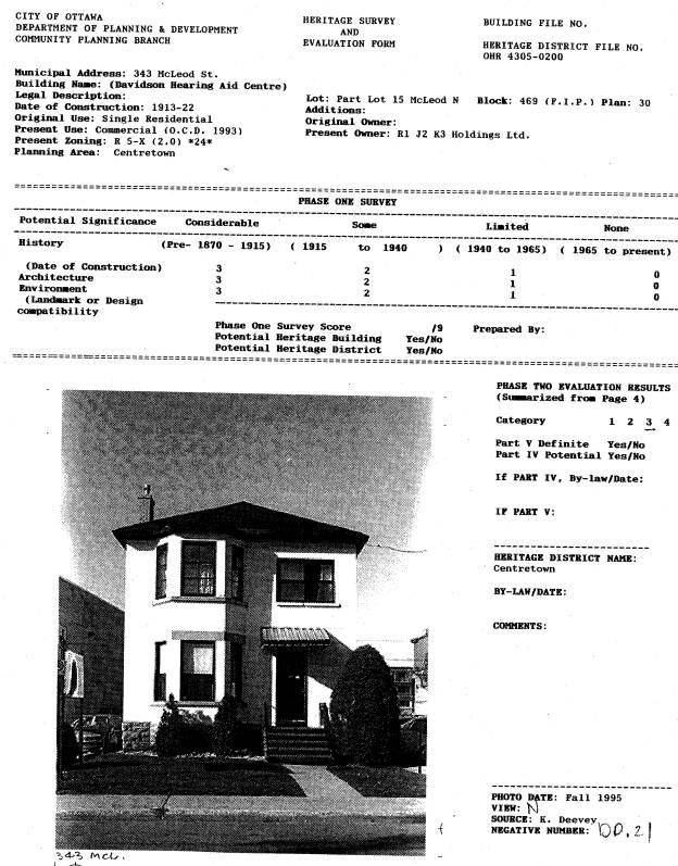
At the rear of the building, amidst a lot of parking spaces, sits 343 McLeod, a white-painted house formerly home to Davidson Hearing Centre. The heritage survey and evaluation form, created in 1996 as part of the Centretown Heritage Conservation District study, estimates the date of construction at around 1913-1922. The houses in the background will be spared its fate, but will have to contend with seven storeys of condo wall immediately adjacent.
By mid-October, the hydro connection (visible in the above photo) had been cut, but there were still blinds in the windows, which would presumably be removed before demolishing the house. The Central is, after all, destined for LEED certification.
The house was one of the first things to go, in late November.
In this shot (actually a night shot taken with long exposure), you can see that 343 McLeod was in fact a red-brick house, like so much of Centretown.
At the front of the building, a large green banner had been added to advertise the condos, and was starting to fall apart when they removed the awning (for safe keeping during construction) in November 2009.
Scaffolding was installed on the façade (the entirety of which can be captured in one frame with my new camera), and this scaffolding was covered with green mesh to minimize dust and debris falling to the ground. A couple of the workers poked their heads out to have a look.
The scaffolding is for the protection of the façade. As approved in September, the façade will be integrated into the new building, but first it will be disassembled brick-by-brick to the roofline, then the rest of it will be secured against a metal frame. The frame and façade will be moved aside, and the new foundation will be built. The façade will be replaced, and the top bit rebuilt brick-by-brick. This engineer's report (PDF) explains the process, the different options, and also shows some close-up images of the architectural details.
Moving along to the 1967 addition, demolition of it began in mid-November, with careful debricking of the rear wall, as mentioned at the time in the Bucket Feet post.
Shortly thereafter, the machines started munching away at it:
On the inside, even an institutional building is generic enough to be familiar. It's always jarring for the insides to be visible from the outside, exposed for all to see like a cut-away diagram.
Here's the de-bricked rear wall of the annex, with the window cap decorations still in place. I presume they saved the bricks for re-use with the finished product. Note also the hole punched into the main building, at the far right of this shot.
In the foreground is one of the window caps laying on the ground. Like the awning, it too was made of wood, and faced with plaster.
The implements of demolition, foreground and background.
A couple more days and a few more rooms chewed away. The surprise is starting to reveal. Do you see it?
Here it is, a remnant of a painted sign on the wall. You can also make out the shadow of the rest of it. It read "Metropolitan Tabernacle". The blog Vanished Ottawa collects photos of these old painted signs.
Surprise number two has to do with the site next door. It seems that the company that is building the Central has bought the site next door at Bank and McLeod (directly across from Tommy & Lefebvre), including the medical building. More condos are apparently on their way.
Councillor Holmes has organized a public information meeting on this new develompent on Tuesday, December 8th, 2009 at 5:30 pm at Centretown United Church (Bank & Argyle, basement), and the developer will be on hand to present plans and concept drawings.
According to Councillor Holmes' release, a mixed-use project with retail at grade and residential units above is being proposed. Not unlike the Central condominiums, whose ground-floor retail will apparently consist of yet another Shoppers Drug Mart.
For the uninitiated, the Metropolitan Bible Church is a former church on Bank Street between Gladstone and McLeod. It was built as the Metropolitan Tabernacle from 1934-1936, and is in the Centretown Heritage Conservation District. The congregation moved to new digs on Prince of Wales Drive a couple years ago, leaving the building vacant. It was used as the returning office for Ottawa Centre in the 2008 general election.
The scaffolding is for the protection of the façade. As approved in September, the façade will be integrated into the new building, but first it will be disassembled brick-by-brick to the roofline, then the rest of it will be secured against a metal frame. The frame and façade will be moved aside, and the new foundation will be built. The façade will be replaced, and the top bit rebuilt brick-by-brick. This engineer's report (PDF) explains the process, the different options, and also shows some close-up images of the architectural details.
Shortly thereafter, the machines started munching away at it:
According to Councillor Holmes' release, a mixed-use project with retail at grade and residential units above is being proposed. Not unlike the Central condominiums, whose ground-floor retail will apparently consist of yet another Shoppers Drug Mart.
Subscribe to:
Posts (Atom)