A couple weeks ago, I was asked on Mastodon (the only social media where I'm active any more) for photos of car parking spaces converted to bike parking corrals. I figured I'd compile them into a blog post, as it's the kind of thing I used to blog about.
As it turns out, most of the examples I know of in Ottawa are actually onstreet car parking space conversions, and most of the photos I have of them will be in a large unsorted digital pile of photos. But I have two examples that fit the bill closely, and a bunch of other interesting examples:
Showing posts with label Laurier. Show all posts
Showing posts with label Laurier. Show all posts
Sunday, May 3, 2026
When car parking becomes bike parking
View other posts on these topics:
Bank,
Bixi,
Cycling,
Elgin,
Hartman's,
Hintonburg,
Jack Purcell,
Laurier,
MacLaren,
Montreal,
Parking,
Toronto,
Waverley,
Wellington


Tuesday, May 20, 2014
Tulips & tower cranes sprouting up
View other posts on these topics:
Construction,
Gardens,
Laurier,
Singles,
Slater
In the first weekend of May, the tower crane for Broccolini's hotel/condo at 199 Slater went up. This is right across the street from the BMO building at 280 Laurier, at the Slater Street "Bank" Transitway station. The BMO building had some nice flowers by its windows to go along with the view.

[Look for more one-photo posts under the label Singles]

[Look for more one-photo posts under the label Singles]
Monday, September 30, 2013
Bronson reopens for the last time
View other posts on these topics:
Bronson,
Chinatown,
Commissioner,
Construction,
Cooper,
Florence,
Gladstone,
James,
Laurier,
McNabb,
Pedestrians,
Roads,
Sidewalks,
Somerset,
Stores,
Streetcars,
Utilities
After two years of construction, Bronson Avenue reopens to through traffic today, whereas it had been closed between Laurier and Somerset (the headline of the linked PSA wrongly states Gladstone). I thought I'd post some snapshots to summarize the progress.

As with last year, the reopening isn't necessarily something to celebrate, as Bronson will no doubt return to its status as a traffic sewer for hasty drivers with little or no connection to Centretown, the roadway is the same width as before the reconstruction (despite the Community's strong desire to get it rebuilt otherwise), but without all the potholes to slow them down. There will hopefully be some degree of relief on the side streets which have been host to cut-through traffic when Bronson was closed.
Recall how disruptive the closure was to road users of all modes. Not only did it disrupt the patterns of people who were just passing through, but when the intersection of Somerset and Bronson was closed, bus riders had quite a walk to get to the nearest bus stop. Customer traffic to the businesses along Bronson slowed to a trickle when Gladstone was closed. There were some attempts to maintain temporary sidewalks for pedestrians also, as seen here in the muddy mess of a street, looking north along the former east sidewalk:

As with last year, the reopening isn't necessarily something to celebrate, as Bronson will no doubt return to its status as a traffic sewer for hasty drivers with little or no connection to Centretown, the roadway is the same width as before the reconstruction (despite the Community's strong desire to get it rebuilt otherwise), but without all the potholes to slow them down. There will hopefully be some degree of relief on the side streets which have been host to cut-through traffic when Bronson was closed.
Recall how disruptive the closure was to road users of all modes. Not only did it disrupt the patterns of people who were just passing through, but when the intersection of Somerset and Bronson was closed, bus riders had quite a walk to get to the nearest bus stop. Customer traffic to the businesses along Bronson slowed to a trickle when Gladstone was closed. There were some attempts to maintain temporary sidewalks for pedestrians also, as seen here in the muddy mess of a street, looking north along the former east sidewalk:
Monday, June 3, 2013
Google Charles View
Google Street View first launched in Ottawa in October 2009, using photos taken in the spring of that year.
In summer of 2012, they came back to take more photos, and these started to go live this past winter. This time around they used branded cars so you knew they were Google Street view. I saw them a few times myself, like here on Wellington Street in late April 2012:

When you view that location in Street View, it does say that the imagery is from April 2012, but clearly from a different day since the weather and traffic are both different.
However, there were some other spots where I saw (and hastily photographed) the Google Street View car where the corresponding images also captured me. Here's the Google Street View car on Gladstone Avenue at Bell Street:

And here's the corresponding photo of me in Street View, a few seconds before I noticed the Google car was there:
Here's another sighting, on Kent Street around Gloucester and Laurier on a mid-April morning in 2012. I had chased it for a couple blocks, tying to get close enough to photograph it. The only two photos I did manage to get are pretty blurry:

I had to get to work, though, and it caught a photo of me peeling off at the Laurier Segregated Bike Lane:
But by chasing it for a couple blocks, I had inadvertently managed to get my picture taken a number times by Google Street View.
It gets better: because I was chasing the Street View car but never quite catching up to it, when you click on the arrow in the above Street View shot to move the view south, I'm still in the same part of the frame for a number of shots until here:
Fun ;)
While we're on the topic of maps, check out the City's new GeoOttawa Maps. These replace the less-user-friendly eMaps, and have a number of new features, including:
In summer of 2012, they came back to take more photos, and these started to go live this past winter. This time around they used branded cars so you knew they were Google Street view. I saw them a few times myself, like here on Wellington Street in late April 2012:

When you view that location in Street View, it does say that the imagery is from April 2012, but clearly from a different day since the weather and traffic are both different.
However, there were some other spots where I saw (and hastily photographed) the Google Street View car where the corresponding images also captured me. Here's the Google Street View car on Gladstone Avenue at Bell Street:

And here's the corresponding photo of me in Street View, a few seconds before I noticed the Google car was there:

Here's another sighting, on Kent Street around Gloucester and Laurier on a mid-April morning in 2012. I had chased it for a couple blocks, tying to get close enough to photograph it. The only two photos I did manage to get are pretty blurry:

I had to get to work, though, and it caught a photo of me peeling off at the Laurier Segregated Bike Lane:

But by chasing it for a couple blocks, I had inadvertently managed to get my picture taken a number times by Google Street View.

It gets better: because I was chasing the Street View car but never quite catching up to it, when you click on the arrow in the above Street View shot to move the view south, I'm still in the same part of the frame for a number of shots until here:


Fun ;)
While we're on the topic of maps, check out the City's new GeoOttawa Maps. These replace the less-user-friendly eMaps, and have a number of new features, including:
- Click "I want to..." at the top and then "View the historical air photos" to see aerials of Ottawa as far back as 1958! (Some of which were used by the URBSite author for this recent post)
- Click on a property to bring up a property report, including a link to the zoning for the site
- Click the little yellow street view icon on the left above the zoom bar and then click a spot on the map to go straight to that location in Google Street View (although it takes you to a limited-feature version of Google Street View hosted by the City)
Monday, March 11, 2013
Around 150 Slater
View other posts on these topics:
150 Slater,
Bridgehead,
Laurier,
Nighttime,
O'Connor,
Slater,
Stores
I haven't written much about the Export Development Canada building at 150 Slater since the three-part series on the demolition and excavation. I doubt there's much interest in construction photos, but here are a few shots of the building itself.
Here is the building at nighttime, from Slater and O'Connor. Notice the spotlights on the underside of the podium canopy:

The finishes make for some interesting surfaces. You can see the exposed concrete pillar inside the building, next to the shell that surrounds the podium.

Within the podium enclosure is a two-storey marble projection above the ground floor. The counterpart is a set back ground floor with retail (the Slater Street frontage seen below is still vacant in 2013).

Along O'Connor, a Bridgehead and a Marcello's have opened up. Like the other small downtown locations, this Bridgehead closes at 6pm. If I recall correctly, the Albert and Bank location is the only one north of Somerset to open late, and even then it still closes earlier than the ones in residential areas.

In contrast to the Slater and O'Connor frontages, the Laurier Avenue frontage on the south side of the lot (separated from the corner by a smaller office building) is very unflattering and hostile to the streetfront. Not one, but two sets of garage doors and a bleak surrounding.

The massing of this side is similar to the Laurier Computer building that was torn down for 150 Slater (I assume this is merely a coincidence). Although that building used to be larger, as covered in a history of the Rideau Winter Club and other curling rinks in the city over at URBSite.
Here is the building at nighttime, from Slater and O'Connor. Notice the spotlights on the underside of the podium canopy:

The finishes make for some interesting surfaces. You can see the exposed concrete pillar inside the building, next to the shell that surrounds the podium.

Within the podium enclosure is a two-storey marble projection above the ground floor. The counterpart is a set back ground floor with retail (the Slater Street frontage seen below is still vacant in 2013).

Along O'Connor, a Bridgehead and a Marcello's have opened up. Like the other small downtown locations, this Bridgehead closes at 6pm. If I recall correctly, the Albert and Bank location is the only one north of Somerset to open late, and even then it still closes earlier than the ones in residential areas.

In contrast to the Slater and O'Connor frontages, the Laurier Avenue frontage on the south side of the lot (separated from the corner by a smaller office building) is very unflattering and hostile to the streetfront. Not one, but two sets of garage doors and a bleak surrounding.

The massing of this side is similar to the Laurier Computer building that was torn down for 150 Slater (I assume this is merely a coincidence). Although that building used to be larger, as covered in a history of the Rideau Winter Club and other curling rinks in the city over at URBSite.
Tuesday, March 5, 2013
Winter cycling, Ottawa, 2013
Even though Citizens for Safe Cycling's 2nd Ottawa Family Winter Bike Ride was over a month ago, I got some photos at unique angles that are worth sharing. Plus, you know, we're still cycling and (despite all protests) it's still Winter.
One of the neat photos I got was this one, from the second floor of City Hall. Get a load of the shadow on that bike at the bottom:

Here's another shot, of CfSC President Hans Moor giving a pre-ride pep talk to the group. He had his own writeup on the ride, which includes a photo of yours truly. That thing on my pant pocket in his photo is the tripod I used to get this high-angle shot:

I went ahead of the group on Laurier to get some shots of the group approaching. People were dismounting to cross the barricade because the snowbank had not been cleared in the opening at Percy to allow a left turn. Cars in both directions waited very patiently for the cyclists to cross.

On another note, there is a public open house tonight to reveal the City's plans for Albert Street through LeBreton Flats. This will (hopefully) show the outcome of the pedestrian report devised from the walkabout in October. It is at 7-9pm at the Dalhousie Community Centre, room 31. As far as I understand, it's a drop-in type event so you don't have to come for the whole duration.
One of the neat photos I got was this one, from the second floor of City Hall. Get a load of the shadow on that bike at the bottom:

Here's another shot, of CfSC President Hans Moor giving a pre-ride pep talk to the group. He had his own writeup on the ride, which includes a photo of yours truly. That thing on my pant pocket in his photo is the tripod I used to get this high-angle shot:

I went ahead of the group on Laurier to get some shots of the group approaching. People were dismounting to cross the barricade because the snowbank had not been cleared in the opening at Percy to allow a left turn. Cars in both directions waited very patiently for the cyclists to cross.

On another note, there is a public open house tonight to reveal the City's plans for Albert Street through LeBreton Flats. This will (hopefully) show the outcome of the pedestrian report devised from the walkabout in October. It is at 7-9pm at the Dalhousie Community Centre, room 31. As far as I understand, it's a drop-in type event so you don't have to come for the whole duration.
Wednesday, September 19, 2012
Peds on Weds: L'Es try something different (or not)
View other posts on these topics:
Bank,
CHP,
Glebe,
Laurier,
Needs Repair,
Nighttime,
Pedestrians,
Renovation,
Sky,
Toronto
Recently some workers have been spotted on Laurier Avenue affixing drywall to the central podium section of the l'Esplanade Laurier office tower:
 Stepping back a bit, both literally and figuratively, the building is a full-block structure surrounded by Laurier, O'Connor, Gloucester and Bank streets.
 Stepping back a bit, both literally and figuratively, the building is a full-block structure surrounded by Laurier, O'Connor, Gloucester and Bank streets.
 Monday, September 3, 2012
Centretown time capsule: August/September 2007
Happy Labour Day everyone!
For today's post, I want to do something a little different. I wanted to give a snapshot of what was happening in Centretown five years ago in August and September 2007. With a high proportion of renters, many Centretown residents—even those active in community affairs—weren't here five years ago (nor was this blog!). For the rest of us, it'll be a trip down memory lane.
The 2007 Labour Day parade, organized by the Ottawa and District Labour Council, ended as usual at McNabb Park for the annual festival with free hotdogs, corn on the cob, and other attractions (if you're reading this post shortly after it goes up, head out there now! They should be there from the end of the parade until 4:30pm). You might recognize this photo of the wading pool as one of the four at the bottom of the CCCA's 'promo cards':
 September 2007 marked the official opening of the Corktown Footbridge on the 11th (the bridge opened to traffic the previous September). Municipal politicians and interpreters in 1830's period dress were there to cut the ribbon.
For today's post, I want to do something a little different. I wanted to give a snapshot of what was happening in Centretown five years ago in August and September 2007. With a high proportion of renters, many Centretown residents—even those active in community affairs—weren't here five years ago (nor was this blog!). For the rest of us, it'll be a trip down memory lane.
The 2007 Labour Day parade, organized by the Ottawa and District Labour Council, ended as usual at McNabb Park for the annual festival with free hotdogs, corn on the cob, and other attractions (if you're reading this post shortly after it goes up, head out there now! They should be there from the end of the parade until 4:30pm). You might recognize this photo of the wading pool as one of the four at the bottom of the CCCA's 'promo cards':
 September 2007 marked the official opening of the Corktown Footbridge on the 11th (the bridge opened to traffic the previous September). Municipal politicians and interpreters in 1830's period dress were there to cut the ribbon.
Monday, August 27, 2012
Capital Pride 2012
Yesterday was the annual Capital Pride Parade, which is orders of magnitude more populous than the last time I was able to get to Pride, back in 2005.
 My usual group, the Human Powered Vehicle Operators of Ottawa (who won Best Float in the 2004 Pride parade) didn't participate this year, so instead I hitched along with the fine folks from the Dusty Owl Reading Series.
The parade was huge, and the crowds were immense. At the end of the parade, everyone files into Marion Dewar Plaza at City Hall for the Pride celebrations (or otherwise disperses). We were float number 80 of 84, so most of the parade was already in by the time we got there. And yet there were still hundreds, if not thousands, of people still clamouring toward the Plaza behind us:
 China Doll (centre) is a fixture of Ottawa's Pride parade, harking from the Shanghai Restaurant, the first Chinese restaurant to open in what is now considered Chinatown. China Doll puts on a raucous Karaoke on Saturday nights that is hilariously over-the-top.
 I hope you had a chance to make it to the celebrations, and if not, come next year!
 My usual group, the Human Powered Vehicle Operators of Ottawa (who won Best Float in the 2004 Pride parade) didn't participate this year, so instead I hitched along with the fine folks from the Dusty Owl Reading Series.
The parade was huge, and the crowds were immense. At the end of the parade, everyone files into Marion Dewar Plaza at City Hall for the Pride celebrations (or otherwise disperses). We were float number 80 of 84, so most of the parade was already in by the time we got there. And yet there were still hundreds, if not thousands, of people still clamouring toward the Plaza behind us:
 China Doll (centre) is a fixture of Ottawa's Pride parade, harking from the Shanghai Restaurant, the first Chinese restaurant to open in what is now considered Chinatown. China Doll puts on a raucous Karaoke on Saturday nights that is hilariously over-the-top.
 I hope you had a chance to make it to the celebrations, and if not, come next year!
Monday, August 20, 2012
Centretown Good Food Market this Saturday
Mark your calendars! This Saturday is the second Good Food Market at the Nanny Goat Hill Community Garden. The market was made possible with support from a community steering committee including other members of the Nanny Goat Hill Community Garden, the Centretown Community Health Centre, the City of Ottawa, and, with my participation, Councillor Diane Holmes' office, the CCCA and the DCA.
But the real legwork was done by Rosemary Tayler, shown here (holding lettuce) with Lesley-Anne, one of the other volunteers.
 The volunteer-run market runs on similar principles to the "Good Food Box", also sponsored principally by the CCHC. The goal is to provide fresh fruits and vegetables in areas where this is not accessible or affordable.
 There are three other Good Food Markets in the city, not all on the same day, however they're all new this year. The plan is see this year if it will work, and to work from there next year. The July market was a great success. (In case you're wondering, you can't sell produce from a community garden plot, so none of the produce is from there).
 This year's second (and final) Good Food Market at Nanny Goat Hill takes place this Saturday, August 25, from 9am to 1pm, at Laurier just west of Bronson. Walk, bike, or bus there, because parking is limited, some in the Ottawa Technical High School lot (enter off Slater), or on Gloucester, one block south.
But the real legwork was done by Rosemary Tayler, shown here (holding lettuce) with Lesley-Anne, one of the other volunteers.
 The volunteer-run market runs on similar principles to the "Good Food Box", also sponsored principally by the CCHC. The goal is to provide fresh fruits and vegetables in areas where this is not accessible or affordable.
  There are three other Good Food Markets in the city, not all on the same day, however they're all new this year. The plan is see this year if it will work, and to work from there next year. The July market was a great success. (In case you're wondering, you can't sell produce from a community garden plot, so none of the produce is from there).
 This year's second (and final) Good Food Market at Nanny Goat Hill takes place this Saturday, August 25, from 9am to 1pm, at Laurier just west of Bronson. Walk, bike, or bus there, because parking is limited, some in the Ottawa Technical High School lot (enter off Slater), or on Gloucester, one block south.
Wednesday, April 25, 2012
Peds on Weds: Footpath of dreams
View other posts on these topics:
City Hall,
Construction,
Laurier,
Pedestrians,
Singles
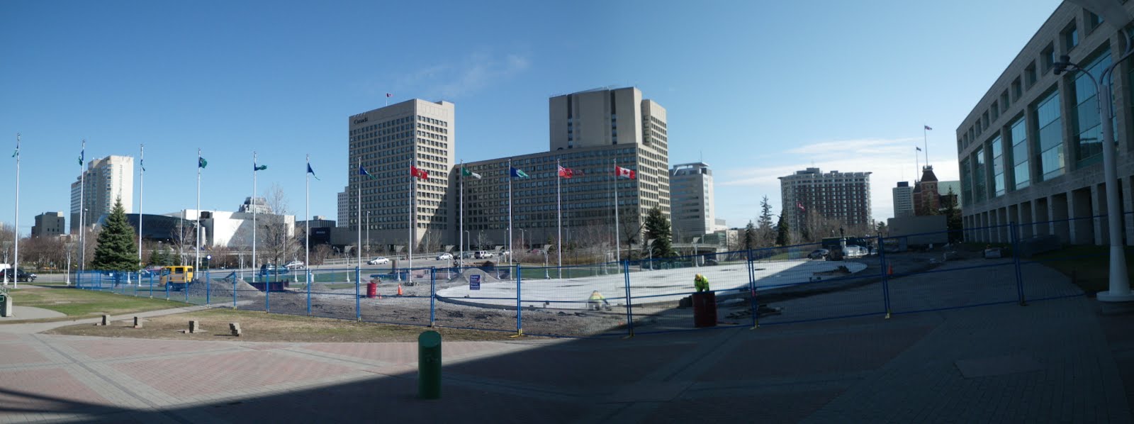
When the Rink of Dreams was built—hastily—last fall, the work naturally disrupted the flow of pedestrians around Marion Dewar Plaza between heading north and east from the Laurier street entrance of Ottawa City Hall. The early thaw highlighted this disruption even further, but workers are now restoring the pathways, as seen in this panoramic view from earlier this month (click to view full size):
 Since the boards around the rink are removed in the off-season, it will be possible to walk on it unobstructed. Indeed, one of the former paths is restored, directing pedestrians right over the surface. It will also be used for events in the summertime, such as the upcoming second annual Capital Vélo Fest in early June.
For more Pedestrians On Wednesday reading, I recommend The Invention of Jaywalking, published yesterday in The Atlantic. The article is acommpanied by a 1909 editorial cartoon which depicts a motorist speeding through newspaper headlines of pedestrians struck by cars. Eric Darwin has also posted this morning a review of recent research conducted on walkability and socio-economic status in different neighbourhoods in Ottawa over at West Side Action.
[Look for more one-photo posts under the label Singles]
 Since the boards around the rink are removed in the off-season, it will be possible to walk on it unobstructed. Indeed, one of the former paths is restored, directing pedestrians right over the surface. It will also be used for events in the summertime, such as the upcoming second annual Capital Vélo Fest in early June.
For more Pedestrians On Wednesday reading, I recommend The Invention of Jaywalking, published yesterday in The Atlantic. The article is acommpanied by a 1909 editorial cartoon which depicts a motorist speeding through newspaper headlines of pedestrians struck by cars. Eric Darwin has also posted this morning a review of recent research conducted on walkability and socio-economic status in different neighbourhoods in Ottawa over at West Side Action.
[Look for more one-photo posts under the label Singles]
Friday, February 17, 2012
Rink of Dreams
As has been widely reported, the Rink of Dreams is now open on the Laurier side of Ottawa City Hall, on Marion Dewar Plaza. It's refrigerated, so it will still be open this weekend even if weather forces the canal to close. It's also free to use.
 Mayor Watson is hosting a Family Day skating party this coming Monday from 11am to 2pm, with free hot chocolate. Details available on Jim Watson's website
[Look for more one-photo posts under the label Singles]
 Mayor Watson is hosting a Family Day skating party this coming Monday from 11am to 2pm, with free hot chocolate. Details available on Jim Watson's website
[Look for more one-photo posts under the label Singles]
Friday, January 27, 2012
CfSC's winter parade
This past Sunday, Citizens for Safe Cycling organized Ottawa's first winter bike parade. Many others have posted their photos and writeups already, and I've put links to those at the end of this post.
 The cyclists gathered at the snowed-over community garden along Laurier at Percy Street. It was encouraging just getting there, as there were three other cyclists in the bike lane on Bay Street as I was heading up.
 The cyclists gathered at the snowed-over community garden along Laurier at Percy Street. It was encouraging just getting there, as there were three other cyclists in the bike lane on Bay Street as I was heading up.
Wednesday, December 21, 2011
The miniature street sweeper
View other posts on these topics:
Arts,
Confederation Park,
Elgin,
Laurier,
Models,
NCC,
Parks,
Renovation,
Statues
Back in October when the Occupy Ottawa protest was still well-established in Confederation Park, I went by a couple of times to see what there was to see. Someone with a generator, bucket, and various tools was at the NCC's miniature bronze map of downtown Ottawa-Gatineau. The more tourist-oriented streets appear to be brass, and this person was cleaning them with a Dremel and various abrasive sponges.
 I didn't realize she wasn't with the protesters, as a gasoline generator and water jugs was the kind of thing the protesters would have with them. But it turns out she works for the firm of the original artist, which was hired by the NCC to do some cleaning and updating some features on the map (like adding the new Convention Centre and removing the Capital Infocentre).
 I chatted with her briefly, but unfortunately it's been too long for me to remember any noteworthy details.
 Click on the photos to view full-size. I think it's a neat throwback to the scale models used by Jacques Gréber to illustrate his plans for the capital (Such as #151 and others listed here)
 I didn't realize she wasn't with the protesters, as a gasoline generator and water jugs was the kind of thing the protesters would have with them. But it turns out she works for the firm of the original artist, which was hired by the NCC to do some cleaning and updating some features on the map (like adding the new Convention Centre and removing the Capital Infocentre).
 I chatted with her briefly, but unfortunately it's been too long for me to remember any noteworthy details.
 Click on the photos to view full-size. I think it's a neat throwback to the scale models used by Jacques Gréber to illustrate his plans for the capital (Such as #151 and others listed here)
Monday, November 21, 2011
Skateboard Lane
Someone spray-painted this in the Laurier Segregated Bike Lane.
 I knew the cycling lobby was getting ahead, but the skateboarders too now? (Uphill, no less) The pedestrians really ought to catch up soon!
[Look for more one-photo posts under the label Singles]
 I knew the cycling lobby was getting ahead, but the skateboarders too now? (Uphill, no less) The pedestrians really ought to catch up soon!
[Look for more one-photo posts under the label Singles]
Friday, September 2, 2011
The Shape of Fog
Hey weather geeks! Remember when we had that stretch of rain in the middle of last winter? (I know, I wish I didn't either) It left us with lots of big puddles in the street, like this one in front of 307 Lisgar. I'm not usually so precise, but this photo was taken at 16:34
 I mention the time because a mere 57 seconds later, a cloud of fog is pushing between the previously-visible Esplanade Laurier twin white towers. (I tweeted a similar photo taken from my Blackberry, though it's too old to show up in my Twitter photo archives.)
 Normally when I think of fog in the city, it's just around. This image really shows that fog isn't necessarily shapeless.
And in case you're thinking I might have had a cloudy smudge on my lens, this one seals it, taken two and a half minutes on. The left tower now looks cloudy and the right one clear, suggesting the fog didn't expand much after passing through the gap between the buildings. In other words, whichever side I'm standing on, the nearer tower is clear and the further tower is obscured by the wall of fog. You can also (not) see the Mondrian at Bank and Laurier at the left.
 It was quite serendipitous that I saw that house and decided to take a photo of it, because I obviously didn't realize the fog would roll in just a few seconds later. I was intrigued by the stark contrast of this little residential house sitting in the middle of parking lots, highrises and apartment buildings.
By the way... as I write up this post in early August, I don't know when I'll post it. Hopefully it's a hot day, and the reminder of the miserable winter helps you appreciate the heat.
 I mention the time because a mere 57 seconds later, a cloud of fog is pushing between the previously-visible Esplanade Laurier twin white towers. (I tweeted a similar photo taken from my Blackberry, though it's too old to show up in my Twitter photo archives.)
 Normally when I think of fog in the city, it's just around. This image really shows that fog isn't necessarily shapeless.
And in case you're thinking I might have had a cloudy smudge on my lens, this one seals it, taken two and a half minutes on. The left tower now looks cloudy and the right one clear, suggesting the fog didn't expand much after passing through the gap between the buildings. In other words, whichever side I'm standing on, the nearer tower is clear and the further tower is obscured by the wall of fog. You can also (not) see the Mondrian at Bank and Laurier at the left.
 It was quite serendipitous that I saw that house and decided to take a photo of it, because I obviously didn't realize the fog would roll in just a few seconds later. I was intrigued by the stark contrast of this little residential house sitting in the middle of parking lots, highrises and apartment buildings.
By the way... as I write up this post in early August, I don't know when I'll post it. Hopefully it's a hot day, and the reminder of the miserable winter helps you appreciate the heat.
Friday, May 27, 2011
Stonecliffe Bare
View other posts on these topics:
Bronson,
Laurier,
Renovation,
Singles
Here's a shot of the Stonecliffe apartments at Bronson and Laurier. I've posted photos of them before, but only from afar and above. I believe the off-blog photoset of mine I linked to from the post Images of Bronson includes a good one.
 All that to say that I had aunts and uncles living there whom I visited dozens of times as a child, and I've passed by it a fair number of times in my adulthood, but never noticed until the day I took this photo that there was a flagpole there. (The balconies are under repair, hence the lack of railings)
[Look for more one-photo posts under the label Singles]
 All that to say that I had aunts and uncles living there whom I visited dozens of times as a child, and I've passed by it a fair number of times in my adulthood, but never noticed until the day I took this photo that there was a flagpole there. (The balconies are under repair, hence the lack of railings)
[Look for more one-photo posts under the label Singles]
Thursday, January 13, 2011
My take on the Laurier Segregated Bike Lane
View other posts on these topics:
CCCA,
Cycling,
Laurier,
Planning and Development,
Roads
Edit: see also Kate Jaimet's push for the Segregated Bike Lane in an editorial in Friday's Citizen
I sent the following message (sans photos) tonight to Citizens for Safe Cycling's public discussion e-mail list in advance of CfSC's Board meeting, where they will be considering their position on the Laurier Segregated Bike Lane pilot project (see ottawa.ca/bikelane). You can view the message in the archives here. It is unfortunate that nobody on Council seems to want to champion this project.
 I will not be at the [CfSC Board] meeting tonight [where the Board will be considering whether or not to support the Laurier Segregated Bike Lane pilot project], but I hope that CfSC's Board chooses to support this pilot project and would like to share my thoughts on the topic.
This proposed lane goes entirely across Centretown, from the Rideau Canal to Bronson, and as President of the Centretown Citizens Community Association (www.centretowncitizens.ca) I have heard many concerns from residents.
These concerns are not unfounded, but as CfSC's policy on bike lanes states, these issues must be addressed. On Tuesday, the CCCA's Transportation Committee met with the City's SBL project manager, Colin Simpson, who explained how these issues would be addressed. The committee was satisfied and will be recommending to the CCCA's Board of Directors that the CCCA support the project.
I sent the following message (sans photos) tonight to Citizens for Safe Cycling's public discussion e-mail list in advance of CfSC's Board meeting, where they will be considering their position on the Laurier Segregated Bike Lane pilot project (see ottawa.ca/bikelane). You can view the message in the archives here. It is unfortunate that nobody on Council seems to want to champion this project.
 I will not be at the [CfSC Board] meeting tonight [where the Board will be considering whether or not to support the Laurier Segregated Bike Lane pilot project], but I hope that CfSC's Board chooses to support this pilot project and would like to share my thoughts on the topic.
This proposed lane goes entirely across Centretown, from the Rideau Canal to Bronson, and as President of the Centretown Citizens Community Association (www.centretowncitizens.ca) I have heard many concerns from residents.
These concerns are not unfounded, but as CfSC's policy on bike lanes states, these issues must be addressed. On Tuesday, the CCCA's Transportation Committee met with the City's SBL project manager, Colin Simpson, who explained how these issues would be addressed. The committee was satisfied and will be recommending to the CCCA's Board of Directors that the CCCA support the project.
Wednesday, November 24, 2010
Lyon Bike Lane: Sharrows on Arlington
As speculated in the post Lyon Street Repaved: Cyclists get their sharrows in September and in Cycling Updates in October, sharrows have been added to Arlington to connect the end of the Lyon Street southbound bike lane to the pathway at Percy.
Someone e-mailed me the day they were applied and I went over to check them out. Here's the view along Lyon Street, with the sharrows on Arlington going West (to the right side of the screen):
 Unfortunately, and as I mentioned in a post to Citizens for Safe Cycling's public e-mail discussion list, they're not exactly the most ambitious application of sharrows. For example, you can't even see them from Lyon, which defeats the purpose of having them out there to show cyclists where to go next when the lane ends.
Once you do make it onto Arlington, you see two problems. First, the sharrows are very close to the curb, which is an area always full of debris and which promotes the idea of "cyclists move out of motorists' way, even on quiet side streets". A Google Images search for Sharrows turns up lots of examples of proper sharrow positioning.
Second, there are only three per block, one at each end and one in the middle. Not exactly rolling out the red carpet. It makes you wonder if they'll do a similarly half-hearted implementation of the Segregated Bike Lane on Laurier, causing that pilot project to fail.
 Here's what they should have done at Lyon and Arlington: sharrows going around the corner so that cyclists can see well in advance where the cycling route goes.
 Once you get along Arlington to Percy Street, there also isn't much indication that you're supposed to turn left here. (Of course, in my cycling route plan for Percy, you'd also be able to continue straight on Arlington).
 In Montreal, where I fell in love with Sharrows, they use them properly: to indicate (a) that cyclists have a right to use the road, and (b) where the otherwise invisible cycling route goes when you get to an intersection. When the cycling route takes a turn, the sharrows make it painless to follow the route, as in this Google Street View of Stuart and Saint-Viateur (click the image to go to the location in Google Street View):
 As with Ottawa's ever-cautious bureaucracy, a small step in the right direction is still a step in the right direction. Let's hope these sharrow show them the way to implementing them more boldly to connect cycling routes.
Check out the public open house on Thursday at City Hall for the Segregated Bike Lane pilot project. The latest proposal is for Laurier Avenue, which actually isn't all that bad.
 Visit www.ottawa.ca/bikelane for more details, including the draft drawings of how the street would be configured and Vélo Québec's review of the proposals. The public meeting on Thursday is from 6:30pm to 8:30pm with a presentation at 7pm.
Someone e-mailed me the day they were applied and I went over to check them out. Here's the view along Lyon Street, with the sharrows on Arlington going West (to the right side of the screen):
 Unfortunately, and as I mentioned in a post to Citizens for Safe Cycling's public e-mail discussion list, they're not exactly the most ambitious application of sharrows. For example, you can't even see them from Lyon, which defeats the purpose of having them out there to show cyclists where to go next when the lane ends.
 Once you do make it onto Arlington, you see two problems. First, the sharrows are very close to the curb, which is an area always full of debris and which promotes the idea of "cyclists move out of motorists' way, even on quiet side streets". A Google Images search for Sharrows turns up lots of examples of proper sharrow positioning.
Second, there are only three per block, one at each end and one in the middle. Not exactly rolling out the red carpet. It makes you wonder if they'll do a similarly half-hearted implementation of the Segregated Bike Lane on Laurier, causing that pilot project to fail.
 Here's what they should have done at Lyon and Arlington: sharrows going around the corner so that cyclists can see well in advance where the cycling route goes.
 Once you get along Arlington to Percy Street, there also isn't much indication that you're supposed to turn left here. (Of course, in my cycling route plan for Percy, you'd also be able to continue straight on Arlington).
 In Montreal, where I fell in love with Sharrows, they use them properly: to indicate (a) that cyclists have a right to use the road, and (b) where the otherwise invisible cycling route goes when you get to an intersection. When the cycling route takes a turn, the sharrows make it painless to follow the route, as in this Google Street View of Stuart and Saint-Viateur (click the image to go to the location in Google Street View):
Check out the public open house on Thursday at City Hall for the Segregated Bike Lane pilot project. The latest proposal is for Laurier Avenue, which actually isn't all that bad.
 Visit www.ottawa.ca/bikelane for more details, including the draft drawings of how the street would be configured and Vélo Québec's review of the proposals. The public meeting on Thursday is from 6:30pm to 8:30pm with a presentation at 7pm.
Monday, September 20, 2010
New post-and-ring bike racks: are there enough?
View other posts on these topics:
150 Slater,
Cycling,
Laurier,
Sidewalks
Back in July, an Ottawa Citizen article by Kate Jaimet announced that the City of Ottawa would be installing permanent post-and-ring racks on the posts formerly used by parking meters.
They're starting to appear on the streets now:

While the article makes it sound like the City came up with this idea on their own, it has been done in Toronto since 1984.
When the City issued a news release in April 2008 announcing that it was looking into replacing parking meters with a Pay & Display system, members of Citizens for Safe Cycling contacted the City to urge them to use the Toronto model to ensure that cyclists will continue to have a year-round place to lock their bikes. At the time, the City was hesitant to commit to this option.
Pay & Display procurement was again an agenda item on the City's Transportation Committee in December 2009, and report didn't mention bike racks. I e-mailed again to ask for them to confirm that enough replacement bike parking would be included in the budget for P&D. During the subsequent friendly e-mail exchange, I directed them to an article in Momentum Magazine, issue 43 (no longer availble online) on how other cities approached the problem of bicycle parking loss during P&D conversion. I also directed them to two articles on this blog, Bike Rack Blunders and Bike Rack Design for Aesthetic and Function.
City Staff assured me that they are "committed to effectively addressing cyclists' parking needs during the P&D implementation process and into the future."
I'm still worried that cyclists will end up having fewer places to lock their bikes, at a time when the numbers of cyclists are increasing.
Have a look at this stretch of Elgin between Laurier and Cooper.
That big grey thing is the new Pay & Display machine. There are four existing parking meters that will be removed, plus a blue Velocity bike rack that is only there between April and November.
They're starting to appear on the streets now:

While the article makes it sound like the City came up with this idea on their own, it has been done in Toronto since 1984.
When the City issued a news release in April 2008 announcing that it was looking into replacing parking meters with a Pay & Display system, members of Citizens for Safe Cycling contacted the City to urge them to use the Toronto model to ensure that cyclists will continue to have a year-round place to lock their bikes. At the time, the City was hesitant to commit to this option.
Pay & Display procurement was again an agenda item on the City's Transportation Committee in December 2009, and report didn't mention bike racks. I e-mailed again to ask for them to confirm that enough replacement bike parking would be included in the budget for P&D. During the subsequent friendly e-mail exchange, I directed them to an article in Momentum Magazine, issue 43 (no longer availble online) on how other cities approached the problem of bicycle parking loss during P&D conversion. I also directed them to two articles on this blog, Bike Rack Blunders and Bike Rack Design for Aesthetic and Function.
City Staff assured me that they are "committed to effectively addressing cyclists' parking needs during the P&D implementation process and into the future."
I'm still worried that cyclists will end up having fewer places to lock their bikes, at a time when the numbers of cyclists are increasing.
Have a look at this stretch of Elgin between Laurier and Cooper.
That big grey thing is the new Pay & Display machine. There are four existing parking meters that will be removed, plus a blue Velocity bike rack that is only there between April and November.
Subscribe to:
Posts (Atom)