Showing posts with label Ottawa River. Show all posts

Saturday, January 4, 2025

Wellington Street Part 12: 50 Years of Rapid Transit in Ottawa

Part 12: 50 Years of Rapid Transit in Ottawa

   [Show/Hide Contents]

I wanted to pick up the narrative of Wellington Street to line up with an important milestone in Ottawa transit history: the 50th anniversary of bus lanes in Ottawa. It doesn't involve much in the way of the theme of this blog series—the connections, disconnections, and renamings of Wellington Street—but there is a dash of that. Alas, I missed the 50th anniversary for this blog post (by over a year!) but I did get a September 2023 article on the topic published in the Centretown BUZZ newspaper.

In the previous post in the series, we left off with the 1974 opening of the Portage Bridge, connecting the west end of Wellington Street, at the Ottawa River Parkway, to Hull, and severing Wellington Street from itself in LeBreton Flats. Today, we'll rewind a couple of years to look at how rapid transit in Ottawa began to reshape traffic patterns on the various Wellington Streets, such as here on the Ottawa River Parkway:1

1974 photo of two lanes of cars curving toward the camera in a landscaped area, and two buses in the distance on a separate pair of lanes (i.e. the Ottawa River Parkway).

Friday, May 5, 2023

Wellington Street Part 11: The Portage Bridge

Part 11: Portage Bridge

   [Show/Hide Contents]

The Jane's Walks Ottawa walking tour festival takes place this weekend, with a launch event picnic dinner under the Booth Street bridge at Pimisi Station today from 6-8pm. This year's festival theme is Building Bridges, which fits in very well with the next section of my blog series on the many traces of Wellington Street: The Portage Bridge.

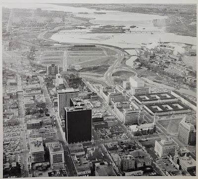
In the previous post, Part 10, we took a step back into the NCC's rearrangement of land and roads in LeBreton Flats in the 1960s. This resulted in the splitting of Wellington Street ending just west of Bay Street as it turns into the Ottawa River Parkway, and connecting to itself via offramps, as we can see here in this photo:1

Aerial view from above looking west in 1967. Centretown/Uppertown in the foreground including Place De Ville and Library and Archives Canada; LeBreton Flats in the midground; Ottawa River, Lemieux Island and Mechanicsville in the distance. Chaudière Island industry at work. West of Bay, Wellington Street becomes the Ottawa River Parkway with an offramp connection to Wellington Street through LeBreton Flats.

That arrangement would be relatively short-lived.

Thursday, December 29, 2022

Wellington Street Part 10: Nepean Bay and the Ottawa River Parkway

Part 10: Nepean Bay and the Ottawa River Parkway

   [Show/Hide Contents]

In the previous post, we talked about the peripheral effects on Wellington street from the Garden of the Provinces construction, the LeBreton Flats expropriations, and the lowering of the C.P.R. Prescott Subdivision (all NCC projects).

Today's post will look at the Ottawa River Parkway, whose history is not well documented insofar as it affects Wellington Street. We're still in the 1960s, prior to the breakup of Wellington at the viaduct covered in part 8.

To get us situated, this colour photo from the early 1960s shows Wellington Street winding up from the bottom of the photo up across the viaduct, through LeBreton Flats, and into downtown:1

Colour aerial photo of LeBreton Flats, Bayview, and Nepean Bay before removal of railroad infrastructure and before expropriation of LeBreton Flats. Wellington Street viaduct, O'Keefe brewery, railyards tracks roundhouse, Chaudière Victoria Albert islands, Ottawa River. Somerset viaduct.

Monday, November 18, 2013

Bad sectors in Centretown

Back in July, my hard disk drive crashed, losing two months' worth of photos (about 1600). At the end of October I got a surprise call from the guy I'd brought it to, who said he was able to recover over 90% of the data. I was able to push this to about 97% of the photos that I had taken since my previous backup.

Some of them, however, were damaged. The hard drive had bad sectors and in the recovery many of the photos were damaged (only a very small number were completely unreadable). The damage inflicted on them actually has a bit of an artistic tone to them. Here's a photo of 222 Queen Street (which is where the RMOC headquarters were before it moved to the building that's now City Hall):


I discovered that I actually had a more recent backup on an external drive, up to mid-June. From this, I was able to push the recovery rate to about 99% of my photos, since many of the damaged photos were taken before then. Here's the original of the photo above:

Thursday, December 27, 2012

3D Thursday: Victoria Island #idlenomore

The Idle No More movement has been embodied by Chief Theresa Spence's hunger strike.

I took some 3D photos of the island back in October, including this one with the Peace Tower in the background.


Source photos for the 3D images:
Left, Right

Spence is Chief of the Attawapiskat First Nation. She's been hunger striking since December 10 to meet with Prime Minister Stephen Harper and Governor General David Johnston. So far, she's still striking. There is plenty of mainstream and alternative media coverage for the latest updates, as well as, of course, the #idlenomore Twitter hashtag.

[Tune in on Thursdays at noon for a new 3D image. View the 3D label for other posts with 3D images]

[Look for more one-photo posts under the label Singles]

Monday, October 15, 2012

Prince of Wales rail bridge

I've been out of town working at a conference, and am even further behind in my blogging and photo-sorting than when I left. So here's a quick blog post to get me started again:

Here is the Prince of Wales railway bridge, silhouetted by a recent sunset with the Ottawa River rippling in the foreground. It connects Ottawa and Gatineau, Ontario and Québec, with Lemieux Island partway along.


As you probably know, this is at the north end of the O-Train line. There is a pathway currently under construction that will run along the O-Train line to connect the Ottawa River Parkway to Dow's Lake, effectively closing the pathway loop for pedestrians and cyclists. When complete, the pathway will have the Prince of Wales bridge on the north end, and Prince of Wales drive at the other end.

[Look for more one-photo posts under the label Singles]

Monday, June 18, 2012

Courting behind the court

The Supreme Court of Canada is a spectacular building, with its iconic façade reproduced in photographs, paintings, and even LEGO.

But have you ever been behind it?

The Court sits on a castle-like stone wall that extends behind the building, out to the top of the cliff over the Ottawa River.

Rather than keeping visitors out, the area behind the courthouse is a spot where tourists can come to get a great vantage point of the Ottawa River, Gatineau, and the Parliament Buildings.

The semicircular wall surrounding this outcrop carries graffiti of visitors from years past. As in the castles of Europe, some of these etchings have become more bold with time. The most popular are couples' names, often circled with a heart. Here we see "Ken & Casey '74" and "Claudie G. Ginis, Greece Aug 27 '72". The capstones of the wall are covered with these names, with the highest concentration closest to the river.

Looking down from this wall, to the west, there is a secluded little park along the edge of the cliff.

This is accessed by a set of stairs across the driveway from the rear of the building. Continuing in the castle theme, the curving walls stone walls are built with narrow window openings to protect from intrusion. However, behind these walls is the Court's underground parking garage—a reminder that this building was built in the age of the automobile.

The view from this place is stunning. In the Winter, you can see the nighttime lights of Gatineau reflected in the ice sheet that covers the Ottawa River.

The Gatineau Tissue Mill, owned by Kruger products, is one of the last remaining facilities of this area, where a vast forest products industry used to extend across the Chaudiere and Victoria islands and through Lebreton Flats. According to an info sheet on the company's website, this plant produces some familiar paper products you see on supermarket shelves: Scotties®, White Swan® facial tissues, White Swan® Napkins and Cashmere® and White Swan® bathroom tissues.