In this blog series about 200 years of physical and nominal changes to Wellington Street, most of the action is West of Bank Street, particularly in LeBreton Flats. The previous post showed the earliest of these changes. Today we will examine the changes to the east end of Wellington Street in the 1800s, as it dabbled with connections to Rideau.
To recap the story so far, Wellington Street and Rideau Street were laid down by Colonel By in 1826, forming the respective backbones of the Uppertown and Lowertown neighbourhoods.
The Fortress at Barrack Hill
Rideau Street—sharing its name with the Rideau Falls, River, and Canal—and Wellington Street, named after the Duke of Wellington (see part 1), were in line with each other, but Wellington only officially extended a little east of Kent Street. The two were separated not just by the alignment of the future Rideau Canal, but also by a section of land reserved for government use as a future military fortification. This 1831 plan of By Town,1 a portion of which we saw in Part 2, shows what that citadel might have looked like along the south shore of the Ottawa River:
However the site at the time only contained a 20-bed military hospital and three stone barrack houses built in 1827,2 giving it the name Barrack Hill. That year, Colonel By also acquired 104 acres of land cut out from the middle of Nicholas Sparks' Concession C2 for Ordnance purposes,3 i.e., construction of the canal and the future fortress. He had a sturdy stone bridge built by the Royal Sappers and Miners across the newly-excavated canal cut.4
Wagon Trail to Sappers' Bridge
The Sappers' Bridge connects with Rideau Street in the east and extends south-west across the Canal. The west approach of the bridge is in the unimproved Ordnance no-man's land reserved for the fort, so instead of a proper street being built, it winds to Wellington Street via a "wagon trail that winds between large boulders, many of which weigh several tons".4
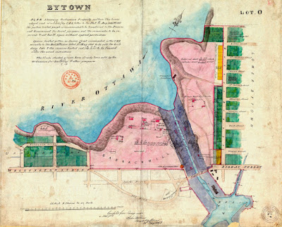
This section from a plan drawn by District Surveyor Donald Kennedy, dated December 4, 1842,5 shows the extent of the Sparks property (outlined in yellow), and the "Part of Lots taken by Government the Property of Mr. N Sparks" which I've outlined in red. This version of the map has some theoretical streets sketched in on the seized land.
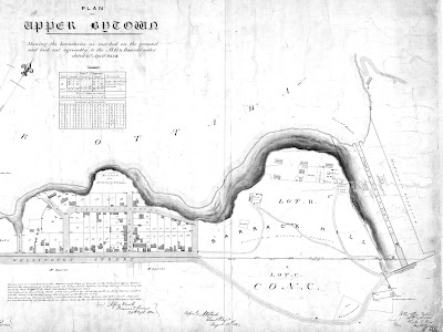
The wagon trail can be seen in this 1845 map6 (the eastern half of the map in the previous post), as can the arrangement of buildings on Barrack Hill and an "Old Burial Ground" in the bend in the wagon trail.
This 1853 map shows, in green, parts of Concession B that had been sold off by the Ordnance "for building & other purposes" in both Upper Town and Lower Town. Also visible are the outlines of Sparks Street extended to the Canal, and the previous wagon-trail road and burying ground.
Sparks Street Extension to the Canal
Here we get to our first disconnection of this end of Wellington Street.
After Sparks won his fight to have the land returned to him in 1849,4,7 he had extended Sparks Street through the area (this area between Upper Town and Lower Town would become known as Centre Town). Wellington Street could not yet be formally extended to the canal because its alignment was still within the portion of Barrack Hill "necessary to be retained for Military Purposes". The wagon trail still connected from the end of Wellington to Sparks, however, and this connection was proposed to be widened more formally with the yellow section in this 1851 plan by Pilkington:8
If we consider the old wagon trail to have been part of Wellington Street, then this would be the first time Wellington was cut off and reconnected to another street.
This drawing from January 1851, also by Pilkington,9 shows a proposed continuation of Wellington Street in line with its current alignment, which would take it through Ordnance lands (it may be hard to read without zooming in, but it says "Proposed continuation of Wellington Street"). The dotted lines optimistically connect up with Rideau Street, but the profile of the elevation along this route, at the top of the page, shows that there is quite a difference in grade (not to mention a Canal!) between Wellington and Rideau.
Wellington Street extension to the Canal
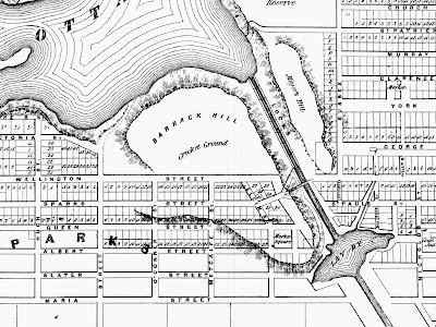
Wellington was eventually extended to the Canal, and Sparks was able to sell the blocks opposite Barrack Hill for development. The diagonal connection from Wellington to Sparks was returned to service as development land. While people could still travel to Sparks to cross the Canal, this blog series is about the connections, disconnections, and renamings of Wellington Street, so a key consequence of this change is that Wellington Street was no longer connected in a continuous path to Sparks Street, Sappers' Bridge, and Rideau Street; one must jog to Sparks on one of the cross streets, as seen on this 1856 map (a more western section of which appeared in Part 2).10
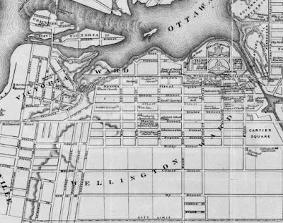
Wellington Street is shown reunited—in a sense—with Sparks and the opposite side of the Canal this 1874 map by Mara & Maingy,11 when the Ottawa City Passenger Railway opened its first line, the Hull-St. Patrick line, in 1870.12 The rails of the horse-drawn streetcar route turn off Wellington to Bank, then take Sparks Street across the Sappers' Bridge and up Sussex. We can also see in this map section the south and west town limits and the Parliament buildings constructed in the 1860s.
Dufferin Bridge restores Wellington-Rideau connection
Wellington's road connection with Rideau was properly restored with the construction of the Dufferin bridge in 1873, named for the then-current Governor General,13 as reflected in this photo from around 1880. The Dufferin bridge (at right) is nearly 100 feet wide, and provided considerable relief to the Sappers' Bridge (left):13,14
Here's a photo of the same scene from a bit higher vantage point, in the 1890s:
In 1911-1913, the Dufferin and Sappers' bridges would be demolished for the construction of Connaught Square/the Plaza*, so that an interprovincial passenger rail link could be run underneath it, alongside the new Union Station and Château Laurier hotel also opening in 1912:15

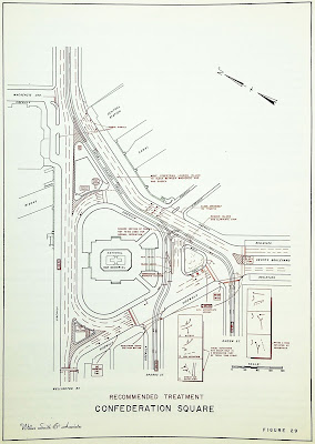
Thereafter, save for construction here and there, Wellington has always had a direct inline connection to Rideau Street in the east. Confederation Square would undergo many changes over the years, most notably the construction of the national war memorial, but with only peripheral changes to Wellington Street, such as this one:16
For the rest of this Wellington Street blog series, we'll focus on the west end of Wellington Street, past Bay/Bronson. Next time, in Part 4, we'll watch as Wellington Street follows the westward expansion of the City of Ottawa. As always, I've done my best to filter out the wrong information and provide sources for the rest; corrections are welcome by email, tweet, or comment (all comments are moderated). See also the full list of posts in the Introduction post.
Since the topic is only peripherally related to Wellington Street and I haven't bothered to add any images to it, I'm putting this zany side story about the name of the Plaza Bridge in a postscript:
Postscript: Confusion Square
The plaza that bridged and partially replaced the Dufferin and Sappers' bridges (what we now know as "the Plaza Bridge"14,17) was initially referred to as "Plaza Laurier" when the project was announced on August 15, 1907.18 It continued to be referred to as "Plaza Laurier" as the project progressed19 when the plans, estimated at $90,000 to $100,000, were ready in November 1910,20 through to at least 1911, including in the announcement of the $235,000 contract awarded to O'Toole and McGillivray, the lowest of four bidders.21 In 1911, some articles dropped the name Laurier and just referred to it as "the plaza" or "the new plaza" (lowercase).22 The name Laurier returns for a few months before disappearing again in March 1912.23
In January 1912, Confederation Square was proposed (in its current location) as an extension of the plaza, and this was assumed to be the official name for the plaza,24 but in July, murmuring started to circulate that the name was not appropriate because it was not easy to pronounce and that the location is "not a square but a plaza", with "Dominion Place" suggested in its place by unnamed members of "official circles".25 Want ads for carpenters by the contractors, O'Toole and McGillivray, refer to "Plaza, front of Post Office" in April26 and "The Plaza" in August.27 The name "the Plaza" (uppercase P) also begins to appear in editorials and news stories in August28 and October.29
In November 1912, the Ottawa Evening Citizen takes matters into its own hands and prints ballots in the newspaper for people to submit their preferences in a two-week 'referendum' between "The Plaza", "Confederation Square", or writing in their own.30 By November 30, Plaza leads Confed Square 10 to 1 with write-in names an order of magnitude smaller.31 Ballots and interim results continue to be printed in the paper until a victor is declared on December 9, 1912, "The Plaza" with 12,190 votes to Dufferin Place's 3,961 and Confederation Square's 3,531.32 This of course, was an unofficial referendum, but the government dragged its feet and waited until March 24, 1913 to officially assign the name "Connaught Place".33,34
The name "Connaught Place" stuck well enough but never fully dominated: a quick search of Newspapers.com articles in Ottawa newspapers between 1900 and 1950 returned 1,544 for "Connaught Place", compared to 1,035 for "Confederation Square" (also 280 for "Connaught Square" and fewer than 100 for "Plaza Bridge" and "Plaza Laurier"). Dwarfing all of these results is "The Plaza", although these could be referring to any plaza, so to narrow it down, '"The Plaza" Rideau' returned 7,175 results, '"The Plaza" Wellington' 6,150, and '"The Plaza" Chateau Laurier' 2,366.
The term "Plaza bridge" (note capitalization) first appeared in November 1912 in an article about the imminent restoration of streetcar service over the bridge,35 but it is still just called "the Plaza bridge" or "the bridge at the Plaza" up into September 1920.36 Only three references to "Plaza Bridge" (uppercase B) appear in September 17-18 papers, but these are ads for an escape artist.37 Only a handful of references to "Plaza Bridge" come up in 1927 and 1928, and by the late 1930s, the name Plaza Bridge is common in both the Citizen and the Journal, with the Citizen preferring the lowercase b.
Oh, also, at the outset there was a lot of controversy over the initial plans to install a statue of Thomas D'Arcy McGee in the square,19 with some proposing instead a statue to the late King Edward VII, "and a further suggestion made by the Women's Historical society is for the erection of a symbolical memorial of Confederation."38
Getting back to the name, I presume the name Confederation Square was reapplied when the war memorial was built (the name gets consistently mentioned more often around 1937-1938). I'm not sure when the name "Plaza Bridge" became official, if ever. It was definitely in common use in the restoration that was completed in 2000,39 but then it was in also common use back when it was officially known as "Connaught Place". What I do know is that the street running over it is called "Wellington" (or, as the Urbsite author pointed out to me, only part of the way across it), and that is sufficient for the purposes of this blog series. Someone else can write up the parts I've missed!
End of Postscript
Show/hide references
- 1: ▲ "Upper and Lower Bytown, showing Lots and Streets." University of Toronto map and data library, Accessed on 2019-11-08, NMC14284, Cartographer Sam Howlett, Chief Draftsman (1779?-1836), John Nightingale, Assistant Draftsman, John J Burrows (1798-1848). Created 1831, revised 1858.
- 2: ▲▲ Haig, Robert. Ottawa, City of the Big Ears, 1975, p. 72.
- 3: ▲ Elliott, Bruce S. The City Beyond: A History of Nepean, Birthplace of Canada's Capital 1792-1990. Corporation of the City of Nepean, 1991, p. 22.
- 4: ▲▲▲ Haig 1975 p. 73.
- 5: ▲ "Plan of Bytown with its limits shewing the exact situation of every street & lot. Drawn to a scale of 6 chains to the inch by Donald Kennedy, District Surveyor.." University of Toronto map and data library, Accessed on 2019-11-08, NMC19056. The Ottawa Public Library also has a photocopy of a version of this map, NMC22556, which has the same title, isn't broken up into panels, and has a completely different drawing of the Union Bridge.
- 6: ▲ "Upper Bytown [Ottawa, ON] boundaries as marked on the ground and laid agreeably to the M. G. & Board's order." Virtual Museum of Canada/Heritage Passages. Carleton University, Accessed on 2019-11-10, Plan of Upper Bytown Shewing the boundaries as marked on the ground and laid out agreeably to the M. G. & Board's order, with a boundary line added 1848 showing the northern limit of the Sparks property (Lot C, Concession C). Dated 23rd April 1845. It's listed as 1950 on the Historic Passages listing but the map itself says 1845.
- 7: ▲ "Nicholas Sparks (politician)." Wikipedia. Wikimedia Foundation, Accessed on 2020-01-05,
- 8: ▲ Pilkington, R. "Bytown (II)." Virtual Museum of Canada/Heritage Passages. Carleton University, Accessed on 2011-09-21, Map dated 1851-04-22. Pilkington, R. Four street plans showing a proposal for extending Wellington Street across Ordnance land, 1851. Ordnance Department. The National Archives of the UK, MR1-1024 (31).
- 9: ▲ Pilkington, R. "Proposed Continuation of Wellington St." Virtual Museum of Canada/Heritage Passages. Carleton University, Accessed on 2011-09-21, Map dated 1851-04-22. Plan showing the proposed continuation of Wellington Street (with yellow lines) in 1851. Pilkington, R. Four street plans showing a proposal for extending Wellington Street across Ordnance land, 1851. Ordnance Department. The National Archives of the UK, MR1-1024 (32).
- 10: ▲ "Carleton and Russell with a correct map of the City of Ottawa compiled from the most accurate surveys by W. A. Austin P.L.S. C.F.." Georectifying maps. Sarah Simpkin, Accessed on 2019-11-05,
- 11: ▲ Mara & Maingy, patent agents. "Map of the City of Ottawa scale 16 chains to the inch 1874." Wikipedia. Wikimedia Foundation, Accessed on 2019-11-05,
- 12: ▲ McKeown, Bill. Ottawa’s Streetcars: An Illustrated History of Electric Railway Transit in Canada’s Capital City. Railfare DC Books, 2006, p. 15.
- 13: ▲▲ Haig 1975 p. 134.
- 14: ▲▲ "Plaza Bridge." Wikipedia. Wikimedia Foundation, Accessed on 2020-01-06,
- 15: ▲ Akben-Marchand, Charles. "Doors Open Ottawa 2012: Chateau Laurier." Images of Centretown (Blog), I first posted this colour-'restored' scan of the Chateau Laurier railway poster (the original of which is framed in my living room) in a 2012 blog post linked in the reference.
- 16: ▲ Smith, Wilbur & Associates. "Figure 29, Confederation Square Recommended Treatment." Traffic and Transportation Plan for Ottawa, Canada. Wilbur Smith and Associates (New Haven, CT), 1955, p. 72.
- 17: ▲ "Vintage Chateau." Urbsite, The Urbsite post misstates that there was never a formal name but it was unofficially called The Plaza Bridge. It was officially (but not popularly) called Connaught Place as described in the rest of my postscript.
- 18: ▲ "New Plaza Laurier." Ottawa Citizen, 1907-08-16, pp. 1, Col 2. The article clarifies that a plaza is to be built, a detail glossed over in an article on the previous day's paper.
- 19: ▲▲ "42 Years Ago: D'Arcy McGee Assassinated on April 7, 1868." Ottawa Citizen, 1910-08-07, p. 1 Col 2. '... two whose memory a monument is to be erected on the Plaza Laurier shortly...' There were plenty of other references to Plaza Laurier in 1910.
- 20: ▲ "Plaza Laurier Plans Ready." Ottawa Citizen, 1910-11-28, p. 1 Col 8.
- 21: ▲ "Contract for Plaza Laurier: Is Awarded to McGillivray and O'Toole, Ottawa.." Ottawa Citizen, 1911-04-10, p. 1 Col 8.
- 22: ▲ "Work on plaza being delayed: Serious Condition Regarding Pier Foundations." Ottawa Citizen, 1911-06-28, p. 1 Col 3. The article refers to to "the plaza" or "the new plaza".
- 23: ▲ "Deep work in plaza erection." Ottawa Citizen, 1912-04-04, p. 8 Col 7. The name 'Plaza Laurier' reappeared in a July 11, 1911 article and again a few times in October, 1911, and January, 1912. By March/April 1912 it is referred to in the article referenced here as 'the new Plaza, near the Chateau Laurier'.
- 24: ▲ "Confederation Square Proposed In Connection With Railway Terminus." Ottawa Citizen, 1912-01-15, pp. 10 Cols 1-2. This is the earliest reference that I could find to Confederation Square
- 25: ▲ "New name for plaza: Dominion Place is Suggested in Official Circles." Ottawa Citizen, 1912-07-09, p. 12 COl 2. A similar article appeared in the Journal the previous day.
- 26: ▲ "Classified ad by O'Toole & McGillivray." Ottawa Citizen, 1912-07-08, p. 10 Col 2. There is also a 'Barber Wanted' ad in May 1912 for 'The Plaza, Rideau and Sussex'
- 27: ▲ "Classified ad by O'Toole & McGillivray." Ottawa Citizen, 1912-08-07, p. 4 Col 2.
- 28: ▲ "Comment [editorial]." Ottawa Citizen, 1912-08-29, p. 6 Col 2. "It is good news that the work at the Plaza is to be pushed with all expedition. Every extra day of its completion means gain to Ottawa."
- 29: ▲ "Good work on the Plaza: Some Slight Alterations in Original Plan." Ottawa Citizen, 1912-10-17, p. 2 Col 1. The article refers to the site many times, always as 'the Plaza'
- 30: ▲ "Plaza supporters secure lead in early stage of referendum to decide satisfactory name." Ottawa Citizen, 1912-11-29, pp. 1 Cols 7-8.
- 31: ▲ "Plaza leads by a large vote in popular referendum to decide much discussed name." Ottawa Citizen, 1912-11-30, p. 1.
- 32: ▲ "Plaza supporters sweep to victory with great rally in last days of campaign." Ottawa Citizen, 1912-12-09, pp. 2, Cols 1-2.
- 33: ▲ "Connaught Place: Government has Chosen Name for the New Plaza." Ottawa Journal, 1913-03-25, p. 5 Col 5. [Clipping by Newspapers.com user kolk]
- 34: ▲ "'Connaught Place' cabinet's choice of name for area formed by union of Sappers' and Dufferin bridges." Ottawa Citizen, 1913-03-24, pp. 1 Cols 4-5.
- 35: ▲ "Cars on Monday: Will Likely Run Over the Plaza on That Day." Ottawa Citizen, 1912-11-21, p. 1 Col 5. (This refers to streetcars)
- 36: ▲ "Made attempt to jump from plaza bridge." Ottawa Journal, 1920-09-03, pp. 1, Col 7. The headline is in uppercase, but likely 'plaza bridge' in the headline is shorthand for 'the bridge at the Plaza' which is referred to in the article itself.
- 37: ▲ "Blackstone Coming Here (advertisement)." Ottawa Citizen, 1920-09-17, pp. 15 Cols 6-7.
- 38: ▲ "For new plaza." Ottawa Citizen, 1912-02-01, p. 3 Col 2.
- 39: ▲ "Plaza Bridge officially reopens." CBC News, 2000-06-19,






No comments:
Post a Comment