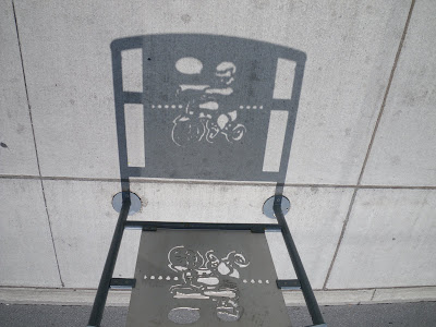
Thanks to sunlight, these racks take on a second life casting shadow images on the sidewalk. And even though it's only fleeting art, it will never wear off the pavement like paint or inlaid pavers would.
 It brings up an interesting issue. They tried widening the sidewalks on Bank Street in the '70s (they even closed off some cross streets, like Lewis), but the space reclaimed from the roads was filled in with trees and rock gardens. So when it was brought back to the state that preceded the 2006-2010 reconstruction, it was a no-man's-land that could be used to relieve traffic, not a space stolen from pedestrians to feed the traffic monster.
This is one of the problems faced by the percent-for-art programme in downtown road reconstruction projects. By adding art to the streetscape, you take away walking space that is often quite scarce. Many other items, like garbage bins and newspaper boxes, already compete for sidewalk space, and efforts to moderate their collective impact have not gone far. One reaction is to incorporate the artwork into these inevitable fixtures, like the bike racks on Bank, or the streetlamp art proposed for Somerset Street West.
Pedestrians aren't entirely forgotten; they are thrown the occasional bone. There are many good things said in the Ottawa Pedestrian Plan, and in addition to the Plan itself, some sidewalks get repaired or improved as part of multimillion-dollar road reconstruction projects (like those on Bank, Preston, and Somerset). But this won't address most pedestrian problems in a reasonable timeframe. Just like the trend in cycling (until very recently), the City doesn't put much money toward pedestrian-specific repairs to fill in the missing links that aren't part of these major reconstruction projects. With all the new condos residents moving in downtown—most not owning a car—the pedestrian network needs to be able to support and attract people who use their feet.
Degredations
Then there are the things that don't even stay the same. Fences were recently installed along the sidewalks on Albert and Slater, redirecting pedestrians' natural flow (a problem faced by suburbs also). When the Laurier Segregated Bike Lane was installed this summer, pedestrians lost their dedicated advance signal at Bank Street (and pedestrians outnumber all other modes at that intersection) and the new left-turn arrow at Elgin for motorists coming off the Laurier bridge puts a convoy of vehicles in the path of pedestrians trying to cross. More recently, the NCC blocked off a pathway connecting Preston and Lebreton Flats residents to the Ottawa River.Now that I'm working in Councillor Holmes' office, these pedestrian facility degradations are one of the things I'll be looking at. And while I know of some of them in Centretown, your help is needed to identify other degradations across the city.
So pedestrian advocates, please tell me: where has it gotten harder to walk recently in Ottawa?
Leave a comment in the box below, or e-mail me at centretown.ottawa at gmail dot com.
[Look for more one-photo posts under the label Singles]
Crossing the Queen Elizabeth Driveway anywhere south of Somerset at rush hour is an adventure. Dodging speeding cars is always such fun! There are plenty of paths that take you from the MUP to the road but then you get no help in crossing. I would love to see a yellow flashing light somewhere and broad pavement markings to indicate crossings. Can't see it happening though.
ReplyDeleteI remember walking from Lees Ave. to King Edward Ave. over the Queensway on the Lees Ave. overpass. I was walking on the "inside" of the curve, if that makes any sense.
ReplyDeleteAt some point, the sidewalk simply ends at an intersection for the Queensway offramp for King Edward/Mann Ave. This is a large, busy, and complicated intersection where the offramp traffic crosses the Lees bound traffic, with a Transitway access as well. (Note that I am NOT talking about the King Edward/Greenfield/Mann intersection.)
At this point, my only legal option is to walk 1 km back to Lees, cross to the other side of the street, and walk back 1 km. I elected to dash across the intersection, which was dangerous as the heavy traffic exiting the Queensway was travelling very fast, and not expecting pedestrians here.
Now, this isn't really a problem, as the sidewalk on the other side of the street avoids the intersection. You could also walk along the Transitway from Lees station. But I did not know this when I began my walk.
The presence of a sidewalk invites people to walk on it, but this sidewalk literally goes nowhere. It is not adjacent to any property, travels for 1 km, and ends abruptly. Why did they construct a redundant sidewalk that goes nowhere?