Wednesday, March 3, 2010

Garbage bin gone at bus stop on Elgin

Often when something as small as a bit of street furniture disappears, its absence isn't noticed. That's why the City does an annual inventory of all the signs it has posted, to make sure none were removed unnoticed.

Thus was not the case when I came on this sight on Elgin, just South of Somerset (a block South of the 100-year-old sidewalk). Taken in mid-October 2009, it's the obvious sign of a garbage bin that had been removed, no more than a few days prior.

I scoured my collection for a photo confirming my recollection that there had, indeed, been a garbage bin there, but my search came up dry. Google Street View to the rescue!

Based on news reports and cross-referencing Google Street View photos with my own, I know this would have been taken around March-April 2009, and it very definitely shows a garbage bin in front of the Oriental House Chinese restaurant, by the bus stop.

Here's a broader shot, taken from inside the Fox and Feather pub at the November bi-monthly Ottawa Blogger's Breakfasts (the next of which is this coming Saturday):

That garbage bin's removal leaves a market untapped: people tossing out their drinks before getting onto the bus. In this photo from mid-November 2009 (a month after the bin was removed), you can see three cups on top of the bus stop's timetable box, plus more trash at the base of the hydro pole.

And a month ago from now, the legacy of the missing garbage bin lives on. As poetic as frozen coffee may be, I don't think it's worth streets covered in litter.

Perhaps the bin was stolen and the City didn't notice, or maybe it was removed because it's not the prettiest piece of street furniture.

Let's just hope we get a bin back at the bus stop to help discourage littering.

Also on the topic of disappearing furniture, the bike racks on Bank Street have been removed for refurbishment. Apparently they weren't properly weather-sealed and were starting to rust. The manufacturer will re-paint them and reinstall them at no cost to the City.

Monday, March 1, 2010

Defacading a heritage church

There's other coverage at URBSite (link at end of post) on the removal of the Metropolitan Bible Church wall, so I thought I'd so something a little different.

I'm restricting the photos in today's post to shots from more or less the same angle, showing progress of work on the façade.

Here's how it looked on November 3, 2009, more or less in its original state:
By November 23, the canopy had been removed.


On November 25, a scaffold was under construction:

The next day, two workers installing a mesh watch me take a photograph. With my new camera, I'm able to fit the whole facade into frame.

By December 8, 2009, the parapet at the top of the wall had been dismatled, for reassembly once the new building was complete. The signage attached to the building was also being removed.

Three days later, we can see the result more clearly now that the scaffolding and mesh have been removed. In addition to the parapet, the second and third storey windows have been removed. The ground floor windows and doors remain intact.

By the 22nd of December, the wooden doors had been removed and the openings boarded up.

Another month later, on January 24, 2010, there was an enclosed plywood work area at the base of the wall.

By February 17th, a steel truss structure had been assembled on the inside and outside of the walls, sandwiching the wall with foam inserts.

Here it is again on Sunday, February 20th, 2010, only something's different...

As you can see from the buildings at the left and right edges, this is the view of the front of the building during the gigantic façade removal procedure. The streets were closed on all four blocks heading away from the intersection of Bank and McLeod, and most of those streets were occupied by flatbed trucks, cranes, police cruisers and other construction-related vehicles.

Looking down McLeod Street, here's the rear view of the front of the building. (How often can you say you saw that?)

And here's the façade again the next day, only it's one and a half storeys underground, stowed away while the new foundation is built in its permanent home.

Here's the front shot of the building once again, literally a cross-section of the building:

Regrettably, I neglected to take any more photos from across the street once the façade came off. But I have plenty more interesting photos from different angles that I will post in the coming days and weeks, and of course I'll be taking more photos as demolition and construction continue, right up through when the façade is returned to its original location.

While you're waiting, don't forget to check out other posts with the Metropolitan Bible Church label.

Edit: See also the URBSite post on the removal of the Bible Church wall

Thursday, February 25, 2010

Stone's throw

I noticed this view in early February, which shows three stone buildings on Elgin Street: the former Normal School (Teacher's College) that is now the Heritage Building wing of City Hall, Knox Church at Lisgar, and the stone house (now rental apartments) behind the stores on Elgin at Cooper, the name of which escapes me.

The Fairmont Château Laurier is also in the background of the photo.

[Look for more one-photo posts under the label Singles]

Wednesday, February 24, 2010

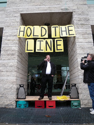
Photos: Hold the line rally reprise

The group Our Ottawa organized a rally today to oppose expansion of the urban boundary. More details in this Citizen article.

Among the speakers, Ecology Ottawa's Graham Saul made an excellent and impassioned speech:

The crowds were not too bad for a snowy Wednesday noon in February:

More photos here: http://picasaweb.google.com/ centretown.ottawa/HoldTheLineRepriseRally20100224

...also, if this rally sounds familiar, it's because Council already decided this issue back in June. There was even a rally, on May 12th:

A number of councillors were at last year's rally, and many of them spoke. Councillors Cullen and Jellett were both in the crowd at the rally today.

Photos from that rally are at http://picasaweb.google.com/centretown.ottawa/ HoldTheLineRallyForASustainableOttawaOnUrbanSprawl

Monday, February 22, 2010

Snider Plaza: Standard-Life Phase III

[Edit November 2010: I hear that this project will not be going forward.]

Tomorrow, Tuesday 23 February 2010, the City of Ottawa's Planning & Environment Committee (agenda) will be considering an application to alter the zoning at Laurier, Bank and Slater, to accommodate the third phase of the Standard-Life buildings in addition to the ones at 280 Slater Street and 333 Laurier.

Here's an overhead shot from Bing Live Maps. The tall red-ish building at the top is 333 Laurier, and its fraternal twin to the North (below it in the photo) is 280 Slater.

The parking lot between it and the buildings along Bank are to be part of the proposed new 18-storey building, and the facades of the heritage buildings are to be incorporated into the new development. More on that later. The block at the corner of Bank and Laurier, once a furniture store and now owned (or at least occupied) by a forestry workers union, is not part of the development.

Here's an aerial shot from 1926 that includes the site. At the centre of the shot is the Jackson building, and the block south of it (to the lower-right) is the subject block. It's certainly changed a lot since 1926.

Saturday, February 20, 2010

Beaver Barracks fire

Long before it was reported in the Citizen, I got a phone call on Wednesday night alerting me to a fire at the Beaver Barracks housing development under construction.

I was just getting off the canal around Fifth Avenue, and managed to take a photo of some white puffs of smoke coming from the site. Major fires usually have large columns of black smoke.

Here's last photo I had taken of this building on the development, from late November:


The roads were closed at Catherine and Metcalfe:

By the time I got to the site, the fire was already extinguished, and firefighters were in the lengthy process of making sure the fire hadn't spread anywhere else.

While we've had a lot of fires lately, it was pretty clear that this one didn't do a whole lot of damage to the building. The word I've heard is that the fire was mainly on one of the scaffolding platforms, so the flames would have looked more severe to onlookers than if the fire were within the building.

I have a number of photos on the ongoing construction of the Beaver Barracks site, but I haven't spent much attention posting them because the CCOC has a good site, including photos of the progress and renderings, at beaverbarracks.ca

Monday, February 8, 2010

Monday & Tuesday: Charlesfort 20-storey Lisgar tower proposal

Charlesfort Developments is going to the Committee of Adjustment on February 17th, 2010, to seek 'minor variances' for a 20-storey residential tower across from City Hall.

Doug Casey, President of Charlesfort, wants to speak to the CCCA at tonight's meeting of the CCCA's Planning & Development Review Committee (5:30pm at Second Cup on Elgin and Lisgar). There will also be a broader community consultation tomorrow (Tuesday, February 9, 2010) at 5:30 p.m. in the Billings Room at City Hall.

As shown in the diagram below, the proposed building is nearly 2/3 heigher than the maximum allowed 37.0 metres. Casey says that the total floorspace approximates that of a big box that fills the entire permitted building envelope, citing the many such boxes in the neighbourhood. But that's just the theoretical box if you build to the maximum dimensions--one is not obliged to build to the maximum, and one is not entitled to exceed one limit merely for staying within another.

As for the site, it's the parking lots at the corner of Lisgar and Cartier, directly across from City Hall and the Heritage Building of City Hall. There's a two-storey red brick house (now serving as offices) next door.

The submission also says that the stepped nature of the building helps to break up its massing. This it does, to an extent, but it does so by reducing the minimum east and west side lot setbacks from 1.5m to zero for the first 13 metres of the site, and by reducing the rear (southerly) setback to 3.5 metres. The red brick house next door will be dwarfed.

The flatness of the front of the building is also evident in the elevation diagram:

I set up some diagrams of my own, based on how the surrounding context would look with this building nearby. The scale is approximate.

Here, for example, is a photo I took this summer of the trees in the island in front of City Hall's Lisgar street entrance. The lot in question is behind it

And here's how it would look (approximately) with the proposed Charlesfort building:

As for the height, I tried to approximate how it would fit into this scene taken from Albert Street. I think the building would actually be a bit taller than how I set it up here, but even so it's clearly taller than anything else in the Golden Triangle.

There are a few opportunities to learn more and get involved:

  • Tonight: CCCA Planning & Development Review Committee meeting, 5:30 p.m., Second Cup, Elgin & Lisgar

  • Tomorrow, Tuesday, February 9: Community meeting to present/discuss the proposal (organized by Coun. Holmes and Charlesfort). 5:30 p.m. at City Hall (Billings Room - second floor)

  • Now to February 16th: Send your comments to the Committee of Adjustment (cofa@ottawa.ca), to Councillor Holmes (diane.holmes@ottawa.ca), and to the CCCA

  • February 17th: Make a presentation at the Committee of Adjustment's Public Hearings at Ben Franklin Place Client Service Centre, 101 Centrepoint Drive.

Sunday, February 7, 2010

Blackburn

There has been some restoration of the exterior of the Blackburn apartments on Somerset West near Metcalfe.

The other day, I was going by and noticed a curious feature of the black lettering.

Not the reflection of the noon-hour sun, but the inverted second "B" in the name. Has it always been like that?

[Look for more one-photo posts under the label Singles]