We interrupt the blog series about the history of Wellington Street to bring you this informational item.
In late January or early February, I got a letter in the mail (since discarded), addressed to "Dalhousie neighbour" (red flag #1), inviting me to something called "NextDoor Dalhousie", which claimed to be a social media site to "connect with neighbours". Sounds nice enough, but obviously somebody's making enough money off of of this "free" app to afford to mail out physical invitations. I've since discarded my letter, but here's a similar one received by a neighbour on Eccles Street in March, 2022:
The top level takeaway—in case the reference to red flags wasn't clear enough—is don't bother signing up, but for the sake of others who, like me, wanted to know more about it before signing up, here's what I've observed after having been signed into the site for a month.
Images of Centretown
Capturing and documenting Centretown's present history
Friday, March 18, 2022
Monday, January 24, 2022
Wellington Street Part 9: The NCC's distractions (early-mid 1960s)
View other posts on these topics:
417,
CHP,
LeBreton Flats,
NCC,
O-Train,
Roads,
Sparks,
Traffic,
Wellington
Part 9: The NCC's distractions (early-mid 1960s) (first or second draft)
In the previous part of this series about the renamings, connections, and disconnections of Wellington Street, we looked at the Ottawa Journal campaign leading up to the August 1969 viaduct transplant that broke Wellington Street apart over the tracks to connect with Scott. Today we'll skip back a few years now to look at what the NCC was up to around Wellington Street in the early 1960s.Tuesday, August 17, 2021
Wellington Street Part 8: Viaduct traffic, Journaled
View other posts on these topics:
Albert,
Bridges,
CHP,
Hintonburg,
Roads,
Scott St,
Traffic,
Wellington
Part 8: Viaduct traffic, Journaled
- History written by the whiners
- 'Battle of the Bridge'
- Bayview slip lane
- Westward city growth gets the wheel squeaking again
- Viaduct repairs 1920s to 1950s
- Wellington Bridge is Falling Down 1960s
- New Wellington Viaduct to be built
- Wellington Street Officially Severed
- 'Replacement' viaduct will disconnect Wellington
- Reaction to Wellington disconnection
- Demolition of the Wellington Street Viaduct
- References
The last connection change was back in Part 4 when the Wellington Street Viaduct was built in 1909 (overtop an existing route). As it happens, the next major change to Wellington Street that we'll look at is when the viaduct was replaced.
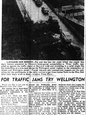
The Viaduct gets an entire post thanks to the Ottawa Journal's obsession with its role as a bottleneck for afternoon rush-hour traffic.1
Monday, May 24, 2021
Wellington Street Part 7: Dawn of "Modern" Transportation Planning in Ottawa
View other posts on these topics:
417,
Albert,
Booth St,
Broad St,
CHP,
Cliff St,
Commissioner,
LeBreton Flats,
Parking,
Planning and Development,
Roads,
Rochester,
Streetcars,
Traffic,
Wellington
Part 7: Dawn of "Modern" Transportation Planning in Ottawa
If A.E.K. Bunnell's 1946 report covered in Part 5 recommended a few tweaks to the road network, and the 1949 Gréber report we looked at in Part 6 reimagined large swathes of the City's buildings and transportation network, a January 1955 report report on traffic and transportaion in Ottawa by consultants Wilbur Smith & Associates came in somewhere in the middle. No renamings or disconnections of Wellington Street in this installment, this time we're going on full traffic nerd mode.This 245-page report1 took a detailed snapshot of traffic in Ottawa, and made a number of specific recommendations, many of which involved Wellington Street. In today's part of the Wellington Street blog series, we'll dive into this report and see what it had to say about traffic in general, and Wellington in particular, in the mid-1950s.
Sunday, April 25, 2021
Wellington Street Part 6: Postwar traffic on Wellington
View other posts on these topics:
Albert,
CHP,
Commissioner,
Hintonburg,
LeBreton Flats,
Mackenzie-King Bridge,
NCC,
Parking,
Planning and Development,
Richmond,
Roads,
Slater,
Streetcars,
Traffic,
Wellington
Part 6: Postwar traffic on Wellington
Back in January 2020, we left off with Part 5, in which we watched traffic get heavier on Wellington Street from the 1910s to the 1940s. After a hiatus to do more research and life getting in the way, we're now back to look at government interventions in and around Wellington Street in the ten years following the end of World War II.The biggest change for the City of Ottawa was on January 1, 1950,1 when Ottawa annexed nearly all nearby developed area, including Westboro, Ottawa West, Hampton Park, Highland Park, Woodroffe, Laurentian View, McKellar, Britannia, etc. Thich comprised 7,420 acres (3,000 hectares or 30 square kilometres) of Nepean and Gloucester Townships,2 as seen in the two large sections on the map below.3 Much of this was burgeoning suburban development which fed a daily stream of workers into downtown Ottawa.
Although Richmond Road was thus brought into the City limits, it retained its name west of Western Avenue, where Wellington ends.4 Since there were no major physical changes to Wellington Street specifically in this period, today's post will look at traffic in general on Ottawa's Wellington Street.
Wednesday, January 29, 2020
Wellington Street Part 5: Tinkering with traffic (1910s to 1940s)
View other posts on these topics:
Albert,
Broad St,
Bronson,
Commissioner,
Hintonburg,
LeBreton Flats,
Parking,
Pedestrians,
Planning and Development,
Preston,
Roads,
Streetcars,
Traffic,
Wellington
Let's continue with our journey exploring Wellington Street as the street was extended, renamed, and rerouted over its 200-year history. In today's post, we'll look at the many little clues that give us an idea of what traffic was like on Wellington Street from the 1910s to the mid 1940s.
During this time, Wellington street wasn't extended or curtailed, but traffic in the city got busier as more people drove automobiles and the City's response to this traffic problem had to mature to cope with it. To set the scene, here's LeBreton Flats from around 1930, with Wellington Street coming in from the left and winding up through to downtown:1
Monday, January 13, 2020
Wellington Street Part 4: As the City grows, so does Wellington (1880-1912)
View other posts on these topics:
CHP,
City Centre,
Dalhousie,
Fire,
Hintonburg,
LeBreton Flats,
Preston,
Richmond,
Roads,
Streetcars,
Wellington
- 1880 Renaming of George Street, Victoria Terrace, and Richmond Road
- Railway Crossings
- Great big fires
- 1908 Renaming of Richmond Road through Hintonburg
- Wellington Street Vidauct
- Wellington widening and paving through Hintonburg
- Clearing up the 'middle section' of Wellington
- 1912 Re-renaming of George Street and Victoria Terrace
- References
Before our foray into the east end of Wellington Street in the previous post, we were talking in Part 2 about the first roads in Ottawa and how the fledgling town's road network began to develop in the new neighbourhood that would one day be called LeBreton Flats.
In this post we'll look at the period from about 1880 to 1912, during which time rail lines cross over Wellington at grade, fires ravage the western part of the street, Ottawa absorbs various suburbs, and an excessive number of bylaws authorize the renaming, widening, and paving of Wellington Street. To set the scene, here's what it looked like to walk in the middle of Wellington Street in 1898:1
Wednesday, January 8, 2020
Wellington Street Part 3: Wellington and Rideau's on again, off again, connection (1820s-1913)
View other posts on these topics:
Canal,
CHP,
Parliamentary Precinct,
Rideau,
Roads,
Sparks,
Wellington
In this blog series about 200 years of physical and nominal changes to Wellington Street, most of the action is West of Bank Street, particularly in LeBreton Flats. The previous post showed the earliest of these changes. Today we will examine the changes to the east end of Wellington Street in the 1800s, as it dabbled with connections to Rideau.
Subscribe to:
Posts (Atom)