Part 9: The NCC's distractions (early-mid 1960s)
In the previous part of this series about the renamings, connections, and disconnections of Wellington Street, we looked at the Ottawa Journal campaign leading up to the August 1969 viaduct transplant that broke Wellington Street apart over the tracks to connect with Scott. Today we'll skip back a few years now to look at what the NCC was up to around Wellington Street in the early 1960s.Throughout the 1960s, the National Capital Commission was undertaking a number of activities that directly or indirectly affected Wellington Street. Three of these were the construction of the Garden of the Provinces park in 1961, the expropriation of LeBreton Flats in 1963, and the completion of the Queensway, all of which had a minor to moderate impact on Wellington Street.
Sparks disconnection and the Garden of the Provinces
It may not be evident to the modern observer that Sparks Street used to extend down to LeBreton Flats through what is now the Garden of the Provinces and Territories Park. This led to a confusing stretched intersection between Wellington, Sparks, Fleet, and Commissioner Streets as described in Part 5.
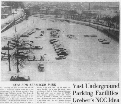
On 1959-12-14,1 the City of Ottawa physically closed the section of Sparks Street which connected to Wellington down the hill. Subsequently on 1960-02-01, Ottawa By-Law No. 23-60 formally closed this section of road.2 This 'before' photo by Newton3 shows the "recently completed Cathedral Hall" above the outcrop, on the southerly fork of Sparks Street. The north fork is covered in snow and lined with utility poles.
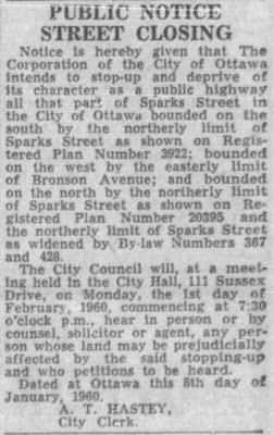
Notice of the closure had previously been published in the Citizen on 8th (below),4 15th, 22nd and 29th of January:
The Journal noted that the link was "used by OTC buses and packed with westbound traffic during the evening rush hour" and "created a serious bottleneck"1 at the intersection where the two roads merge, right before the road forks again at Wellington and Fleet less than 100m south.
This road closure was so the NCC could build a "Triangle Park" at Sparks, Wellington and Bay at a site that previously contained "old factories and warehouses".5 The NCC's fiscal year 1960-61 budget included the first ten percent of the park's anticipated half-million-dollar price tag.5 A political-gossip column in February 1961, calling the site in its current state a 'bomb crater', said "Both George McIlraith and Richard Bell have been ... searching for a name to further emphasize that the Capital is a national community belonging to all Canadians and not simply the property of the citizens of Ottawa".6 A November article blamed blasting at the park site for damage to the two churches sitting opposite it on Sparks Street.7
The NCC's 1961-1962 Annual Report included this aerial photo of the park under construction, by then called the Garden of the Provinces Park "in view of the approach of the hundredth anniversary of Confederation".8 It was officially opened by Prime Minister Diefenbaker on 1962-09-25, with the three acres to the west to be landscaped the following year.9
There is a good post discussing the Garden of the Provinces on Urbsite, including this historical photo of the Sparks road/hill and of the park, from the same vantage as the snowy photo above.
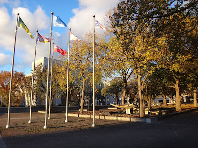
The park was renamed to "Garden of the Provinces and Territories" in 2005.10 It's still a nice place to visit, if a little underused. It's a popular spot for wedding photos, but no such couples were there the day I took this photo:
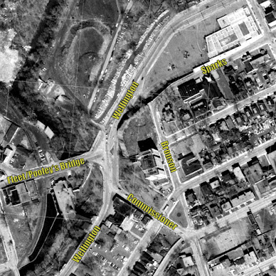
While the removal of this connection didn't involve breaking or renaming Wellington Street itself (only a connection to it), it helps to illustrate the configuration of this leg of Wellington Street as it continues westward. The 1965 aerial photos from GeoOttawa show that without Sparks, the elongated intersection of Wellington/Fleet/Wellington/Commissioner is only slightly less messy:
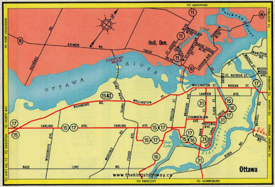
Remember that completion of the Queensway is still four years away,11 so Wellington, at four to six lanes, is still one of two major routes west from town and thus was designated as Highway 15 Alt:12
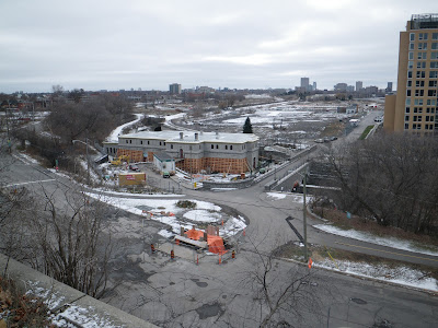
This block of Sparks Street still connects Bay to Bronson one way on the southern 'tine' of the former fork, as seen here in 2012:
LeBreton Flats Expropriation
The midcentury photos of the Sparks ramp/Garden of the Provinces Park above show the dense industrial buildings in LeBreton Flats in the background. This photo in the Journal shows them from above, with Wellington Street creeping along the bottom of the photo:13
Wellington Street is a bit difficult to trace through LeBreton Flats with all the buildings in the way, so "On April 14, 1962 by Order in Council, the Diefenbaker Cabinet expropriated all of the land lying between Wellington Street and the Ottawa River. The next day, most of the Lebreton Flats area north of Primrose was added."14 The flattened Flats are seen here in 1965:15
This topographic map from Carleton University's collection shows the area at almost the exact same time as the photo above:16
The expropriation of 150 acres (60.7 hectares) of LeBreton Flats was transformative (it would be fair to say destructive) to the social and economic fabric of the area, including the removal of a substantial portion of the French-speaking residents (shown in area 1 of the map below) of the Dalhousie neighbourhood:17
However, since the LeBreton Flats expropriation has been documented in many other places and it left the streets intact (including Wellington), I won't dwell on the subject. The connection it has with Wellington is how it cleared the canvas for future changes in LeBreton Flats that will be discussed in Parts 10 and 11.
The Queensway and the CPR trench
The buildings in LeBreton Flats—77 of which were demolished in the fiscal year ending 196318—were just one set of the NCC's expropriations in the early 1960s. Other projects include Highway 417 (the Queensway), Gatineau Park, the Macdonald-Cartier bridge, the Greenbelt, various parkways in Ottawa and Hull, and the relocation of railways from downtown to the new train stations in Ottawa and Hull.19,20
As the Queensway was opened in phases between 1960 and 1966,21 it gradually stole the title of Ottawa's primary east-west highway from Wellington Street, particularly after the Wellington Street Viaduct was removed in 1969.
The one railway line left in LeBreton Flats was the north-south C.P.R. Prescott subdivision crossing both the Ottawa and Rideau rivers (the one which we now know as the O-Train Trillium Line and the Chief William Commanda, ex Prince of Wales, bridge). Rather than remove it, the NCC dug it into a trench.
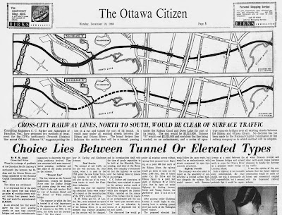
This headline from 1960 shows the NCC mulling over whether to raise or bury the line:22
This lowering project was done in three phases: the tunnel under Dow's Lake, the open cut north from the Arboretum to Beech Street, and the continuation to Somerset Street (north of which it continued at grade under the Somerset and Wellington viaducts).23 The $4.5 million lowering project, the third phase of which "will extend from the Queensway to the Wellington Street viaduct" was complete in 196624 (This didn't substantially affect Wellington Street since it was already grade-separated from the tracks).
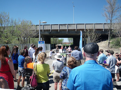
Incidentally, the C.P.R. trains ran on the existing at-grade tracks alongside the trench as it was cut. The resulting right-of-way became the O-Train (Trillium Line) multi-use pathway (MUP). Here's a photo looking north under the Queensway at the 2013 official opening ceremony for the O-Train pathway:
The Queensway overpass over these rails was built extra wide not just to accommodate this transition from at grade to lowered tracks, but also to accommodate a future north-south expressway, later known as the "Champagne Arterial",25 which would connect with the east-west Downtown Distributor. This Champagne Arterial idea was eventually canned, and when this overpass was rebuilt last year, it was installed over a much narrower gap:
So in today's post, we saw Sparks broken off from Wellington, and traffic eased up a bit, but not much else affecting Wellington Street itself. In Part 10, we'll see Wellington Street (still in its 1960s complete form) be almost broken up but temporarily saved by a one-leafed clover.
As always, I've done my best to filter out the wrong information and provide sources for the rest; corrections are welcome by email, tweet, or comment (all comments are moderated).
Show/hide references
- 1: ▲▲ "Close Sparks, Wellington Link." Ottawa Journal, 1959-12-09, pp. 1, Col 5.
- 2: ▲ "By-Law Number 23-60: A by-law of the Corporation of the City of Ottawa to provide for stopping up part of Sparks Street." City of Ottawa Bylaws, 1960, 1960-02-01, p. 53.
- 3: ▲ Newton. "Site for Terraced Park (photo with caption)." Ottawa Citizen, 1960-01-20, p. 13.
- 4: ▲ Hastey, A. T. (City Clerk). "Public Notice Street Closing." Ottawa Citizen, 1960-01-08, pp. 41, Col 8. The same notice appeared in the Citizen on January 15, 22, and 29, 1960.
- 5: ▲▲ Hume, J. A. "NCC Projects: $2 Million Set For Rail Move." Ottawa Citizen, 1960-02-15, p. 7.
- 6: ▲ Jackson, Richard. "Hill Talk." Ottawa Journal, 1961-02-18, p. 17.
- 7: ▲ "Blame Govt. Blasting For Damage." Ottawa Citizen, 1961-11-02, pp. 1, Col. 8.
- 8: ▲ NCC Annual Report (1961-1962), part one. National Capital Commission, 1962, pp. 23 (text), p. 24 (photo).
- 9: ▲ NCC Annual Report (1962-1963), part one. National Capital Commission, 1963, p. 17.
- 10: ▲ "Garden of the Provinces and Territories." National Capital Commission, Accessed on 2022-01-19.
- 11: ▲ "The Operations Branch." NCC Annual Report (1966-1967), part one. National Capital Commission, 1967, (No page numbers) While outer sections opened earlier, the Queensway was completed in October 1966.
- 12: ▲ "The King's Highway 15A (Alt.) Ottawa." The King's Highway. Cameron Bevers, Accessed on 2019-12-22, Try as I might, I couldn't find any references to Highway 15A in any newspapers or maps, aside from the ones from this website.
- 13: ▲ "COA/12D86/CA 7689/Alex Onoszko." Alex Onoszko collection (aerial photography). City of Ottawa Archives, March 1962.
- 14: ▲ Robinson, James. The Curse of LeBreton Flats: An Untold History of Ottawa. Baico Publishing, 2014, p. 52.
- 15: ▲ Taylor, John H. Ottawa: An Illustrated History. J. Lorimer and Canadian Museum of Civilization, 1986, Photo was likely taken by Alexander Onoszko.
- 16: ▲ Spartain Air Services, 1965. "Ottawa 1:2,400 Scale Topographic Maps (1957-1965), Sheet No. I 16." Ottawa Resource Collection: Historical. Carleton University MacOdrum Library, Accessed on 2019-11-24, The links appear to have been broken since I accessed the files.
- 17: ▲ Aasen, Clarence T. Ethnicity, Politics and Urban Planning: Political Uses of French and Italian Ethnicity In Two Local Area Planning Processes (Doctoral Thesis), 1979, p. 74.
- 18: ▲ NCC Annual Report (1962-1963), part one. National Capital Commission, 1963, p. 12.
- 19: ▲ NCC Annual Report (1961-1962), part one. National Capital Commission, 1962, pp. 20, 23.
- 20: ▲ NCC Annual Report (1962-1963), part one. National Capital Commission, 1963, pp. 14-15.
- 21: ▲ "Ontario Highway 417." Wikipedia. Wikimedia Foundation, Accessed on 2021-12-19, The Queensway opened in phases, as described and referenced in the Wikipedia article.
- 22: ▲ Arnott, W. M. "Choice Lies Between Tunnel Or Elevated Types." Ottawa Citizen, 1960-12-19, p. 3.
- 23: ▲ NCC Annual Report (1965-1966), part one. National Capital Commission, 1966, p. 10.
- 24: ▲ "Montreal firm awarded work on rail project." Ottawa Citizen, 1964-09-23, pp. 3, Col 2.
- 25: ▲ "Issue 2. LeBreton Boulevard." The LeBreton/Bayview Project: Status Report of the Tripartite Planning Team Technical Steering Committee & Chief Administrative Officers, 1991-04-12, p. 10. This document can be found as Document 5 attached to the 1997 OPA for LeBreton Flats.




![Looking North in October 2021 from the Young Street footbridge over the O-Train tracks (removed for Phase 2 South expansion). Conduit on the side of the trench. Still no apparent progress on reconnecting the path, which has been detoured to Preston Street during the overpass replacement project [progres has been spotted in January 2022]. Looking North in October 2021 from the Young Street footbridge over the O-Train tracks (removed for Phase 2 South expansion). Conduit on the side of the trench. Still no apparent progress on reconnecting the path, which has been detoured to Preston Street during the overpass replacement project [progres has been spotted in January 2022].](https://blogger.googleusercontent.com/img/a/AVvXsEiqdAHXdBn_8RpUOHekx0_BEMWZobxKPXfb2C1irxAg_V7yCIFfYdeufgFFg-9TG3gDrqCX-y_IIR_QtpVJOxt457cm3jzrhyWSJSn5lAgIvBOT_FbT7Ry-K4GWeURHypiHZso1mJuWefxXhwkwuOJeEo3nkeTbCWvaFVNQajP1INrJXzIgjiJWn5cx=s400?name=20211022_165034.JPG)
No comments:
Post a Comment