Let's continue with our journey exploring Wellington Street as the street was extended, renamed, and rerouted over its 200-year history. In today's post, we'll look at the many little clues that give us an idea of what traffic was like on Wellington Street from the 1910s to the mid 1940s.
During this time, Wellington street wasn't extended or curtailed, but traffic in the city got busier as more people drove automobiles and the City's response to this traffic problem had to mature to cope with it. To set the scene, here's LeBreton Flats from around 1930, with Wellington Street coming in from the left and winding up through to downtown:1
Viaduct makes Wellington an artery for the 1910s
This 1914 map of Ottawa2 has concentric circles showing distances to the city centre in increments of half a mile, with the focal point on Connaught Place: right where Wellington and Rideau meet. So as it had been at Bytown's inception (see Part 1), Wellington remained a primary artery well into the 20th century.3
The 1909 Wellington street viaduct we looked at in the previous post was a harbinger of the suburban auto traffic that would become a hallmark of this still new century. West end residents clamored in 1913 for the streetcar to travel on the new Wellington Street viaduct, instead of on Somerset,4 to speed up their commute by avoiding the Bank Street crawl, but the structure could not accommodate streetcars without an upgade from 40 feet wide to 60.5 By carrying the public road—sans streetcars—over the steam railway tracks, the structure ordered by the Dominion Railway Commission6 literally paved the way for the growth of the then-suburban neighbourhoods in which people would commute into town with their private car.
Speeding and slowing traffic on Wellington in the '20s
Although horse-drawn vehicles still regularly appeared in the 1920s,7 demand grew for the viaduct to be improved both for streetcars and private automobiles. In a 1922 letter to the Ottawa Journal, A.H. Jarvis of 157 Bank Street says that "It is the most direct route for auto traffic into the city, but the wooden road-bed is not fit for such traffic."4
The City did agree with the Ottawa Electric Railway in 1924 for various streetcar line extensions to be made over a three year period, including over the Wellington Street viaduct in the third year of the agreement,8 but the cost of strengthening the viaduct would have to be split between the City, the OER and the steam railways, and there was no consensus on who should pay.9 Also in 1924, the Wellington street viaduct was re-floored,10 a new Traffic bylaw11 and a new Use, Care and Occupation of Streets bylaw12 were passed, and a new Ottawa Electric Railway streetcar barn was built on Champagne Avenue (now a self-storage facility opposite City Centre) which necessitated tracks on Elm, Champagne and Wellington to connect to existing trackage on Preston and Albert/Wellington.13
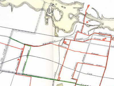
These connecting rails were removed from Wellington between Preston and Champagne in 1942, not having been used,14 and streetcar routes don't traverse the Wellington Street viaduct on this 1929 transit map15 nor on any others I could find:
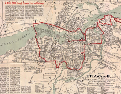
As for the downtown section of Wellington Street, it was falling into such disrepair that traffic was diverting onto Sparks Street.16 In 1920, the City of Ottawa and the Government of Canada agreed for the federal government to maintain Wellington Street's roadway and sidewalks.17 It was, after all, a part of the City's scenic route published on various tourist maps, like this one from 1929:18
With the federal government responsible for maintaining Wellington in front of the Parliament buildings, the City hoped in October 1925 that when the street was repaved it would also be widened "for traffic now using Sparks street, in addition to furnishing excellent parking areas."16 This repaving took place in 1927, during which poles and wires were removed from both Wellington and Sparks, and the cross-streets on the block between them.19
Rather than widen the street to enable parking, the City's Commissioner of Works, A. F. Macallum, recommended in July 1927 that parking be prohibited in front of Parliament Hill, a suggestion that heard objections from H.K. Carruthers, secretary of the Automobile Club.20 The following April, the Board of Control and Police Commission began enforcing a parking ban on both sides of Wellington east of Bank Street "in deference to the wish expressed by the prime minister".21
The municipal-federal agreement was renewed and expanded in November 1945 to include roadway and pavement maintenance of all of Wellington Street from Connaught Square to Queen Street West in LeBreton Flats, and sidewalks on Elgin, Laurier, and most of Wellington (the entire north side and the south side wherever federal properties fronted on it).17 As part of this agreement, ratified in January 1946, the Government of Canada would increase its annual payment from $100,000 to $300,000, recopuing any rent collected by the City from the Ottawa Electric Railway Company for their use of the roads now maintained by the feds.22
As one might expect, repaving the street and removing poles and parking from Bank to Elgin made Wellington into "a speedway for motor traffic as well as a main artery," creating a significant hazard for pedestrians.23 Installation of traffic signals was complicated by the lack of poles and wires on which to mount them, so instead it was proposed in April 1928 for four-way signals mounted on "ornamental iron standards in the center of the street at the intersections of Wellington street with Elgin, Metcalfe, O'Connor and Bank streets."24
According to the City Solicitor, such pedestals would be an illegal obstruction,23 so instead they were planted on 'safety isles' designated and placed by By-law in February 1929. At these four-way traffic signals, left turns were to be made on the red light and right turns on green, a system which "is favored in the principal United States cities and that the Ontario legislature probably will pass similar legislation this session."25
Anticipation of a provincial law regulating traffic signals also left the city without its own By-law, leading quickly to a situation where some drivers outright ignored the lights, knowing they were not enforceable. A 10 mph (16 km/h) speed limit was used as a proxy since most red light runners exceeded this limit.26 Drivers continued to speed and ignore the lights until, "at the request of J. B. Hunter, deputy minister of public works," police officers were stationed on the traffic islands in May 1930.27
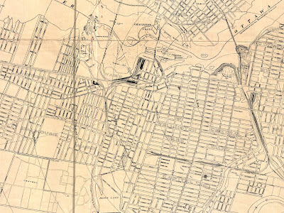
The decade ended with what is technically another "closure" of Wellington Street in October 1929, when a 33.6 square foot (3.1 m2) sliver of Wellington was closed to allow half the width of a property to extend into the street by 11.5" (29.2 cm),28 as indicated on this later topographic map:29
West End pedestrian woes in the '30s and '40s
While I didn't do it for every year, I found all the minor road and traffic approvals relating to Wellington Street in the bylaw books, many of which were in Hintonburg, much of which is in the aerial photo below (Wellington ends at the city limit, after which it turns into Richmond Road two blocks east of the Island Park Drive traffic circle).30 Traffic signals were approved for Wellington and Parkdale in August 193131
Street lighting was also an issue in the '30s. In December 1932, the Civic Traffic Committee "resolved to again urge Board of Control to take some action towards improving the lighting at the west end of the Wellington street viaduct,"32 and four years later "It was reported by Inspector Barlow that traffic officers have difficulty in handling pedestrian traffic in the evening at Wellington and Kent streets because of insufficient street lighting."33
In January 1938, the Elmdale West Municipal Association sent a letter to the City's Board of Control complaining about the surface of the Wellington street viaduct, among other issues.34 By July, mention is made of "covering the blocks on the Wellington street viaduct with an asphalt surfacing", which "proved satisfactory, reduced the skidding and wore (sic) for considerable time."35
Traffic Engineers' secret weapon—road paint36—was employed in 1936 at the east end of Wellington to separate westbound motorists into lanes for those continuing west and those turning south around Connaught Place.37 Their other secret weapon was deployed in response to speeding on Wellington between Broad and Preston: in November 1937 the Civic Traffic Committee agreed to erect two signs reading "Caution — Pedestrian Crossing."38 This came after signs were installed on the viaduct in February 1933 to discourage passing, which had led to cars being run into railings.39
In November 1934, Garland was made one-way northbound to allow better synchronization of the signals at Wellington and Somerset, where A. H. Stirling of 1100 Somerset Street said that "pedestrians needed wings to get across in safety."40 This remained a problem until at least June 1937, when it was pointed out that traffic at this intersection would flow on Wellington when stopped on Somerset, and vice-versa, leaving no opportunity for pedestrians to cross!41 Crosswalk markings painted at Somerset and Wellington in 1944 were panned by letter-writer George S. Wellington (no relation) as useless to protect pedestrians crossing the bumper-to-bumper traffic: "Apparently a large percentage of motorists seem to think the white line is a mere decoration on the road."42 This aerial photo43 was also taken in 1944 and shows the offending crosswalk markings at Somerset and Wellington:
Through the 1940s, the growth of traffic continued, and the municipal response reflected "the modern tendency towards wider thoroughfares to take care of the growing vehicular traffic."44 Official City Historian Lucien Brault provides a contemporary description of the roadways:45
"During recent years changing traffic conditions have presented problems of continually increasing difficulty to the engineers. New material and new methods of construction have had to be adopted in order to obtain hard-wearing surfaces and foundations capable of standing the wear and tear of heavy mechanical transport. Streets with lighter traffic are mainly surfaced with bituminous or tarred macadam (86 1/2 miles). Where traffic is particularly heavy use is made of asphalt paving and foundations are generally of reinforced concrete (81 miles). To-day only 1/8 of a mile of street is not covered."
Throughout the 1940s "the modern tendency towards wider thoroughfares" was realized on Wellington Street in bits and pieces, such as nipping triangles from the corners of properties to round out turns at intersections. For example, the Wellington and Commissioner intersection, "described by Mayor Lewis as one of the worst corners in Ottawa," had two corners widened in 1942, a triangle of land from the southwest property zealously offered to the City at no cost by its owner, M. Zagerman, and a triangle from the southeast property excised from parkland already owned by the City.14 Other corner roundings along Wellington included one at Preston46 and one at Broad47 in December 1947.
Underscoring the fact that Wellington Street was a key artery for the west end of the city, we learn that 80 percent of the traffic at Wellington and Holland in 1944 was travelling east-west along Wellington.48 At the same intersection, use of police officers instead of the existing traffic signals sped up traffic so much that it created such a hazard for pedestrians, and the signal was restored in October 1947 at the request of the West End Business Mens (sic) Association.49 New traffic signals were added at Wellington and Bayview in April 1949, at the same time that red flashing lights were installed at various high-collision locations elsewhere in the city to warn nighttime drivers.50
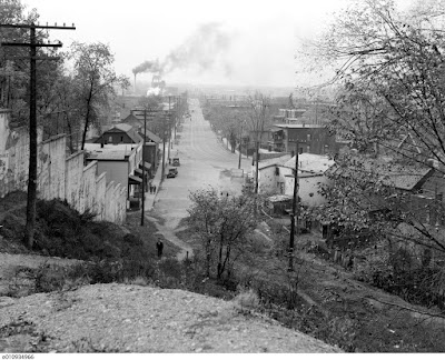
The City's traffic inspector recommended streetside boulevards within the existing right-of-way be removed to make way for more traffic, along Booth Street north of Albert, Wellington from Broad to Champagne, and on the south side of Wellington between Holland and Parkdale. "He suggested that the streets would be greatly widened and the flow of traffic facilitated." The recommendation was referred to a subcommittee for consideration and presumably was carried out.49 You can see boulevards on both sides of Albert Street in this photo looking down from Nanny Goat Hill, with Wellington off in the distance:51
This wider road likely permitted the installation of temporary traffic islands at the Wellington/Broad/Albert intersection, which were approved to be made permanent in June 1949.52
Toronto traffic consultant pays Ottawa a visit
Separately from the Gréber work being done at the federal level, the City hired consultant A. E. K. Bunnell in March 1946 to work on a municipal Beautification Plan. He had participated in the Holt report in 1913-1915, the TTC from 1919-1925, and notably in 1944 became director of the Toronto Planning Board, which was responsible for both "controlled access" highways and green belt in Toronto.53
At a May meeting of the City's Traffic Committee, Bunnell was asked "to begin his investigation of Ottawa's traffic problems, immediately". At that meeting, Bunnell said that the street car in cities the size of Ottawa "is rapidly disappearing", in part because they require all traffic on a road to stop whereas buses only obstruct the curb lane.54 Bunnell attended a meeting of the Board of Trade in June where the Board's president, C. E. Pickering, submitted their priorities, particularly the precedence of moving traffic over parked cars. "Mr. Pickering said the amount of double parking now going on, on the main streets was "a crime"."55
Bunnell conveyed his report to the Civic Traffic Committee in August. The "Bunnell report" recommended "sweeping changes"56 on three major areas, all of which touched on Wellington Street.56,57 To aid traffic flow, this included swathes of peak-hour parking restrictions across the Laurier-Kent-Wellington-Elgin area "where the problem is congestion of street cars, automobiles and trucks, due to the narrow streets, street car tracks, curb parking and loading of unloading of commercial vehicles at the curb during business hours", and twelve separate recommendations relating to Connaught Square/Rideau/Sussex/Mackenzie.
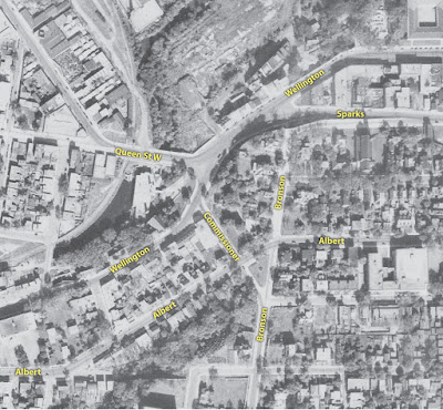
The third Wellington-adjacent area in the Bunnell report was Bronson-Commissioner-Queen-Wellington (the one described earlier by the mayor as the worst in the city), "where the problem is not traffic congestion, but [need for] the elimination of the traffic hazard created by the multiplicity of intersections, sharp descending grades and lack of vision,"56 as shown here in 1944:43
The Bunnell report illustrates a more methodical approach to handling traffic than ad hoc recommendations by traffic inspectors or ratepayers. Bylaws were passed and the Traffic Committee agreed to temporarily enforce Bunnell's suggested parking regulations starting on Monday, October 7, and unofficial "no parking" signs installed by businesses outside their stores were ordered removed.58 On December 17, a week before the trial regulations were set to expire, they were extended to January 25. Alderman L. L. Coulter wanted this to be extended even longer "until the snow was off the ground and more cars were on the streets [than in just the winter months]" but was overruled, since "the system, on the whole, was proving successful."59
End of Part 5
I had initially planned to lump the 1910s to the 1960s period of Wellington Street's history into a single post, mostly glossing over the period between the two wars during which Wellington Street saw no substantial changes and focusing on some major NCC projects affecting Wellington in the 1960s and 1970s (The period above was literally a single bullet point in my initial outline). However, the NCC projects turned out to be interesting enough for their own post (currently planned for Part 7 and Part 8), and as I accumulated more material for the remaining period I decided to divide that into two parts also. Parts 5 was so far the hardest to put together, since they involve a laundry list of details that don't easily fit into a single narrative, and unlike most of the rest of this series, I didn't have any of it hashed out before I posted Part 1—hence the delay between the previous part and this one.
So join us next time for a continuation of looking at traffic and road works into the 1950s and 1960s in Part 6. I imagine another delay as I get that one sorted out, then 7 and 8 should come easily after that.
As always, I've done my best to filter out the wrong information and provide sources for the rest; corrections are welcome by email, tweet, or comment (all comments are moderated). (*When it's ready, I'll note the planned posting date in the full list of posts in the Introduction post)
Show/hide references
- 1: ▲ "A Tourist's Guide to Ottawa." Urbsite, Accessed on 2014-01-05, I got the photo from this Urbsite blog post. I'm not sure where he got the photo, but it appears to date from the early 1930s.
- 2: ▲ "Drawing No. 29: Plan of Ottawa, Hull and Vicinity 1914." Ottawa Historical Maps. Carleton University MacOdrum Library, Accessed on 2019-11-25, This is from the 1915 Bennett report (Report of the Federal Plan Commission on A General Plan for the Cities of Ottawa and Hull 1915); the link here is to Carleton U's scan of the map.
- 3: ▲ Haig, Robert. "1826." Ottawa, City of the Big Ears, 1975, p. 64.
- 4: ▲▲ "Letter to the editor from A.H. Jarvis." Ottawa Journal, 1922-01-19, p. 6 Col 3.
- 5: ▲ "Want Another Car Extension." Ottawa Journal, 1913-11-19, p. 10.
- 6: ▲ "The Level Crossings [editorial?]." Ottawa Citizen, 1909-12-27, p. 6 Col 1.
- 7: ▲ "Fireman Saves Girl From Wild Runaway." Ottawa Citizen, 1924-06-23, p. 4 Col 2. The article describes one incident on Wellington near Fairmont involved a runaway horse with the owner's 10-year-old daughter rescued by firefighters "a short time before the rig was upset and smashed by the mad animal", and another incident where a man was thrown from a wagon drawn by a team of horses at Parkdale and Wellington.
- 8: ▲ "By-Law No. 5687: A Bylaw to authorize the execution of an agreement between the Corporation and the Ottawa Electric Railway Company." Ottawa Citizen, 1923-12-28, p. 9. The draft bylaw was published in the Citizen on this date (see link to clipping in this reference); I have yet to look up the bylaw itself.
- 9: ▲ "Application for level crossing on Somerset St." Ottawa Citizen, 1927-05-07, pp. 5 Cols 1-2. The City applied to the Board of Railway Commissioners to approve this strengthening operation and apportion the costs between the City, the OER, and the steam railways.
- 10: ▲ "By-Law No. 5773: A By-law authorizing: a borrowing of $15,000.00 for the purpose of paying the Corporation’s share of the cost of reflooring the Wellington Street Viaduct." City of Ottawa Bylaws, 1924, 1924-07-17, pp. 253-256.
- 11: ▲ "By-Law No. 5801: A By-law of the City of Ottawa regulating traffic." City of Ottawa Bylaws, 1924, 1924-08-05, pp. 379-393. This bylaw replaces about 60 or so sections (of over 200 sections) of by-law No. 3378 from 1912, the rest of which is repealed by 5808, as well as bylaws 5574 and 5633.
- 12: ▲ "By-Law No. 5808: A By-law respecting the use, care and occupation of the streets for other than purposes of traffic." City of Ottawa Bylaws, 1924, 1924-08-05, pp. 409-423. This bylaw repeals bylaws 3378, 3423, 3540, 3569, 3705, 4452, 5229, 5396 and 5574. Modern day equivalent is Use and Care of Streets bylaw.
- 13: ▲ "By-Law No. 5735: A By-law to authorize the Ottawa Electric Railway Company to lay down a single track railway on Elm and Wellington Streets and on Champagne Avenue." City of Ottawa Bylaws, 1924, 1924-06-02, pp. 161-162. The bylaw makes reference to an 1893-06-28 agreement between the City and the OER. The Champagne Barn is now a self storage facility opposite City Centre.
- 14: ▲▲ "Install Sewers Before Building of Pavement." Ottawa Citizen, 1942-05-08, pp. 22, Cols 1-2.
- 15: ▲ "Folder containing scanned and PDF historical Ottawa transit maps." Maps, Data and Government Information Centre (MADGIC). Carleton University MacOrdrum Library, Accessed on 2020-01-15, The 1929 map can also be found in Bill McKeown's book Ottawa Streetcars, printed on the inside of the dust jacket.
- 16: ▲▲ "Advance Scheme For Speeding Up Traffic In City: Advisory Committee Decides To Request Dominion Govt. To Widen Wellington Street. / Asks Fewer Stops For Street Cars." Ottawa Citizen, 1925-10-14, p. 9 Col 1.
- 17: ▲▲ "Govt. Increases City of Ottawa Grant to $300,000: Will Pay Tax On Local Improvement." Ottawa Journal, 1945-11-08, pp. 1 Col 6, p.12.
- 18: ▲ "Map of Ottawa and Hull also Suburbs Aylmer, Britannia, Carlington, Deschènes, Eastview, Gatineau Point, McKellar, Rockcliffe, Westboro, Woodroffe." Ottawa Historical Maps. Carleton University MacOdrum Library, Accessed on 2019-11-25.
- 19: ▲ "Clear two streets of wires and poles: Wellington and Sparks Streets Free by End of Year." Ottawa Citizen, 1927-05-18, p. 5 Col 5.
- 20: ▲ "Parking ban considered for Wellington St.; Auto owners object." Ottawa Citizen, 1927-07-15, p. 4 Col 4.
- 21: ▲ "New Conditions for Regulating Traffic On Hill." Ottawa Citizen, 1928-05-02, p. 2 Col 4.
- 22: ▲ "City Ratifies Agreement With Govt. Covering New Grant Of $300,000." Ottawa Citizen, 1946-01-08, pp. 6 Cols 1-2.
- 23: ▲▲ "Wellington St. Signals [Editorial]." Ottawa Citizen, 1928-12-18, pp. 26 Cols 1-2.
- 24: ▲ "Decide on Four Traffic Signs: Pedestal Fixtures Are to Be Erected for Signals on Wellington Street." Ottawa Citizen, 1928-04-28, p. 20 Col 4.
- 25: ▲ "Traffic Signals In Operation On Day of Opening: Automatic Control System Now Being Installed On Wellington St. in Front of Parliament Buildings." Ottawa Citizen, 1929-02-05, p. 11 Col 4. I don't understand it either!
- 26: ▲ "Traffic Lights Disregarded by Some Motorists: Knowledge That There is No Bylaw Governing Signals, Drivers Pass by Without Stopping. Noticeable Particularly on Wellington Street." Ottawa Citizen, 1929-03-14, p. 1 Col 7.
- 27: ▲ "Parking Space on Elgin is Discussed: Ald. Lewis Holds City Should Not Compete With Private Garages." Ottawa Citizen, 1930-05-12, p. 2 Col 7.
- 28: ▲ "By-Law No. 6749: A By-law to provide for the stopping up of a certain part of Vittoria [sic] Street (now Wellington Street) as shown on registered Plan Number 2." City of Ottawa Bylaws, 1929, 1920-10-21, pp. 647-648. This extends a 35' 1.5" section of a property's frontage into the street by 11.5". The bylaw title refers to Vittoria Street but should refer to Victoria Terrace (Victoria Street was renamed from Vittoria Street in 1880 to avoid confusion).
- 29: ▲ "Ottawa 1:1,200 Scale Topographic Maps (1934-1979) D-10." Ottawa Resource Collection: Historical. Carleton University MacOdrum Library, Accessed on 2019-11-24.
- 30: ▲ "Aerial photos 1933, Series A4571." uOttawa NAPL Index. University of Ottawa Geographic, Statistical and Government Information Centre, Accessed on 2019-11-11, p. 13.
- 31: ▲ "Police to Enforce Go to Right Rule At Safety Islands: More Control Apparatus Approved by Traffic Committee—Lights for Two Streets." Ottawa Journal, 1931-08-06, p. 13 COl 4.
- 32: ▲ "Warns Committee Against Too Much Traffic Control: Ald. W. R. Low Retiring as Chairman of Traffic Body, Gives Departing Message." Ottawa Journal, 1932-12-24, p. 5 Col 5.
- 33: ▲ "Ald. W. H. Marsden Thanks Committee For Co-operation." Ottawa Citizen, 1936-12-19, p. 6 Col 1.
- 34: ▲ "Board of Control Opens Drive for Earlier Estimates: Will ask reasons." Ottawa Citizen, 1938-01-21, p. 15 Col 3.
- 35: ▲ "Claims Over-Lapping in Control City Buildings." Ottawa Citizen, 1938-07-15, p. 13 Col 2. Subhead 'Wellington St. Viaduct'. The article doesn't identify which commissioner made the comments.
- 36: ▲ "Centerline: The Surprising History of Lane Markings." The History Guy (YouTube channel), Accessed on 2020-01-23, The 'secret weapon' comment has to do with a common refrain in the cycling community that painted bike markings on the road do not themselves make streets safer for cyclists. This link is to a neat summary of the history of lane markings in the US.
- 37: ▲ "Order Drastic Cuts In Time of Parking." Ottawa Journal, 1936-08-15, pp. 17 Cols 1-2. (The headline refers to a reduction from 5h to 1h parking and 2h to 1h on some streets including 2 blocks of Wellington).
- 38: ▲ "Plea for Man Getting Many Parking Tickets." Ottawa Journal, 1937-11-20, pp. 5 Cols 6-7.
- 39: ▲ "Plan Campaign To Save Children From Accidents: Praise For Police." Ottawa Journal, 1933-02-11, p. 5 Col 5.
- 40: ▲ "New Traffic Lights Will Be Installed: At Intersection of Metcalfe and O'Connor With Somerset." Ottawa Journal, 1934-11-17, p. 20 Col 5. The headline is about a different item covered at the traffic committee meeting in which the Somerset/Wellington/Garland changes are discussed.
- 41: ▲ "Suggests Change Of Lights At Busy Point: Inspector Barlow Offers Plan for Benefit of Pedestrians." Ottawa Journal, 1937-06-05, p. 28 Col 6.
- 42: ▲ Wellington, George S. "Letters from Citizen Readers: At Somerset and Wellington." Ottawa Citizen, 1944-08-05, p. 18.
- 43: ▲▲ "Aerial photos 1944, Series A7194." uOttawa NAPL Index. University of Ottawa Geographic, Statistical and Government Information Centre, Accessed on 2019-11-11, p. 5. (Both instances of this reference are for different crops of the same aerial photo.).
- 44: ▲ "Board Opposes Tracks On Sparks Street." Ottawa Journal, 1938-03-18, p. 15 Col 1.
- 45: ▲ Brault, Lucien. Ottawa Old & New. Ottawa Historical Information Institute, 1946, p. 102.
- 46: ▲ "By-Law No. 9904: A By-law of the Corporation of the City of Ottawa dedicating certain land as part of Wellington and Preston Streets." City of Ottawa Bylaws, 1947, 1947-12-15, p. 537. This is a 25'x20'x20' triangle of the southwest corner of Wellington and Preston, later consumed by a further widening of Preston Street.
- 47: ▲ "By-Law No. 9905: A By-law of the Corporation of the City of Ottawa dedicating certain land as part of Wellington and Broad Streets." City of Ottawa Bylaws, 1947, 1947-12-15, p. 539. This is for an 8'x12'x12' triangle at the northwest corner of Wellington and Broad, still visible as a discrete parcel on GeoOttawa.
- 48: ▲ "Letter to the editor by John Powers, Chairman, Civic Traffic Committee." Ottawa Journal, 1944-03-23, p. 8 Col 6. Responding to a complaint about a 'Right turn on green [only]' sign at Holland and Wellington.
- 49: ▲▲ "City Traffic Rules Changes Announced." Ottawa Citizen, 1947-10-18, p. 16 Col 5.
- 50: ▲ "'Blinkers' On Uptown Corner Now." Ottawa Citizen, 1949-04-02, p. 3.
- 51: ▲ "Albert St looking west from top of cliff, west of Bronson." Library and Archives Canada, Accessed on 2019-12-04.
- 52: ▲ "Approve Two Changes in OTC Bus Routes." Ottawa Journal, 1949-06-23, p. 40 Col 5.
- 53: ▲ "A. E. K. Bunnell to Advise City On Ottawa Beautification Plan." Ottawa Journal, 1936-03-25, pp. 3 Cols 3-6.
- 54: ▲ "Ban on Sparks Street Parking Urged by City Traffic Expert." Ottawa Journal, 1946-05-15, pp. 3 Cols 1-2.
- 55: ▲ "Board of Trade Submits Traffic Ideas To A. E. K. Bunnell." Ottawa Journal, 1946-06-28, p. 24 Col 1.
- 56: ▲▲▲ "Parking Ban on Wide Ottawa Area Proposed by Traffic Expert." Ottawa Journal, 1946-08-21, p. 13. The report referenced was reproduced in the Journal article.
- 57: ▲ "Engineer Makes Proposals To Ease City Traffic Congestion." Ottawa Citizen, 1946-08-21, p. 13.
- 58: ▲ "Traffic Committee Ready to Enforce Bunnell Report." Ottawa Journal, 1946-09-28, pp. 26 Cols 5-6.
- 59: ▲ "Uptown Traffic Plan Extended for Month." Ottawa Citizen, 1946-12-17, pp. 12 Cols 1-2.




I don’t see the need of a “(sic)” tag on the word “wore”, being the past tense of “wear”, which the asphalt (reportedly) did well.
ReplyDeleteI must have read that too fast. Thanks! I've made a note to change that when I update my posts.
Delete