Part 10: Nepean Bay and the Ottawa River Parkway
In the previous post, we talked about the peripheral effects on Wellington street from the Garden of the Provinces construction, the LeBreton Flats expropriations, and the lowering of the C.P.R. Prescott Subdivision (all NCC projects).Today's post will look at the Ottawa River Parkway, whose history is not well documented insofar as it affects Wellington Street. We're still in the 1960s, prior to the breakup of Wellington at the viaduct covered in part 8.
To get us situated, this colour photo from the early 1960s shows Wellington Street winding up from the bottom of the photo up across the viaduct, through LeBreton Flats, and into downtown:1
Nepean Bay Infill
Nepean Bay is the part of the Ottawa River between Lemieux Island and the Chaudière falls that comes down to touch the Ottawa River Parkway. Originally, it extended all the way to the CPR tracks at Wellington Street (now Scott/Albert Street). This aerial photo from 1928 shows how the bay was used to store lumber waiting to be processed in the mills of the Chaudière district:2
Future plans for a road link over Nepean Bay appear on the Gréber report's map of the proposed highway system for the capital region, however his report does not make any suggestion to fill in Nepean Bay:3
Such plans were also known in July, 1950 during the discussion about changing the lane configuration on the Wellington Street Viaduct: "Controller Tardif was against making any change at present. Eventually, he said, there would be a bridge further north across Lazy Bay [which is just west of Nepean Bay] and much of the traffic would follow the Federal District road across at this point."4
In January, 1960, one Ottawa-area MP expounded the benefits of filling in Nepean Bay, as opposed to merely building a bridge:5
"George McIlraith (Lib.-West Ottawa) says a lot of valuable land would be created were the filling of the bay on the Ottawa River, to the east of the CPR bridge and to the north of the Wellington Street viaduct, to be undertaken.As an aside, McIlraith's comment about the body of water having no name is hogwash; it was called Nepean Bay at least as far back as the 1912 topographic map included in Part 4 of this series, and on Gréber's maps, including above.
Mr. McIlraith says the water there is only four or five feet deep and that the building of an earthen causeway on which trucks could take out fill would not be a major project.
There are apparently no landowners in the vicinity of the project who would be adversely affected. From the city's viewpoint there would be a central area to be filled. In modern methods of building up land there are no objectionable features which would have any ill-effect on the center of the city.
Fill land would be suitable either for building, for a park or for parking. In other Ontario cities lovely parks have been created by the filling up of low-lying areas. The jobs usually take several years or more but the end result is worthwhile.
Strangely enough, we could find nobody who was sure that this bay we're talking about has a name. It is given no name on the National Capital Commission maps of the area."
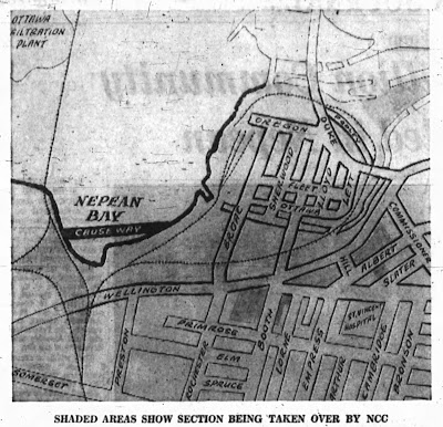
That June, a proposed causeway to carry the future Ottawa River Parkway was shown in the NCC's plans, according to this Ottawa Journal article. The causeway would be built using rock excavated from the Green's Creek collector sewer tunnel, the water will be drained out and south of the causeway they would "reclaim the land with garbage fill".6
By the time the order was given to expropriate LeBreton Flats in April, 1962, work had already started on filling in Nepean Bay, according to the Journal, "first with garbage, then by sand and finally top soil".7
The expropriation of LeBreton Flats in conjunction with this filling in would facilitate "a recreational and park area [that] will be reclaimed from Nepean Bay" and "a connecting link between the Ottawa River Parkway and Wellington Street."8
The NCC was using the fill from the Prescott Subdivision excavation and other infrastructure projects across the city to fill in Nepean Bay. Half a million cubic yards of rock fill were used just to put a causeway across Nepean Bay.9,10, as seen in this City of Ottawa Archives photo published in a Kitchissippi Times article:11
The 1965 aerial photos on GeoOttawa maps12 shows the filling in still in progress, and when you overlay the present-day topography, you can get a sense of how much of the bay was filled in: (It's right around the same time as the oblique photo shown in the previous post)
This ca. 1968-1971 map shows the topography of the filled in part of Nepean Bay after the Ottawa River Parkway was completed.13
Ottawa River Parkway
As hinted above, filling in Nepean Bay helped lay the groundwork—literally—for the NCC to build a parkway along the Ottawa River. This was anticipated for a while; a 1953 Journal rant about traffic on Wellington Street laments that "Traffic men are reconciled that it will get worse, as the West End continues expanding, before it gets better . . . and it won't get better until the FDC extends Scott with the continuation of the parkway planned for the sweep of Nepean Bay."14
The Kitchissippi Times article has a lot of interesting information about the Ottawa River Parkway and the impact it had on Kitchissippi. I'll be focusing on the impact it had on the course of Wellington Street.
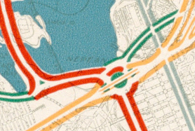
The Gréber Report said "The parkway contemplated from Nepean Bay to Britannia is the third most important addition to the scenic roads system."15 When the NCC expropriated most of LeBreton Flats in 1962, their model showed Wellington Street splitting into four west of Bay Street, with two sections following Wellington's existing route along the south end of LeBreton Flats, and the other two following the contour of the Ottawa River shoreline in order to surround a number of government office buildings planned for the Flats.16
The completion of the 417 in 1966 meant that Wellington Street and Carling Avenue were no longer the primary west-end commuter routes. Wellington's status as part of provincial Highway 15A (Alternate), had already been removed in 1960.17
The Ottawa River Parkway project began in 1961 with surveying and initial grading of the section18,19 west from Parkdale to Churchill, which opened in Autumn 1963.20 "The new parkway is designed for four lanes of traffic with a dividing median of varying width."21
Initially, the five-mile-long parkway was only planned to be extended as far east as Bayview,22,19 interrupted by the north-south Champagne expressway downtown (see the Gréber map excerpt above). Following the expropriation of LeBreton Flats, surveying began immediately for the easterly extension of the route into town,21 "creating a future driveway from Government House via Sussex Drive, past Parliament Hill, and along the river to Britannia."8 Photos of the NCC models for these parkways and government buildings appeared on the front pages of both the Journal (above), and the Citizen.
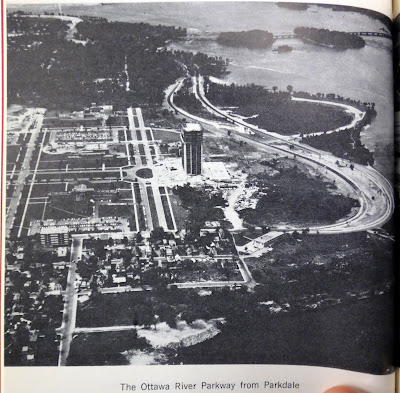
The first leg of the Ottawa River Western Parkway, a 1.5-mile section from Parkdale to Churchill, opened in early December 1963,23 shown here:24
After opening the Churchill to Woodroffe section of the parkway, and a "riverfront footpath" between Parkdale and Churchill,25 in autumn 1964, "Construction continued [on the ORP] in an easterly direction from Parkdale Avenue to the western approach to the railway overpass at the Prince of Wales Bridge" in 1964-1965,10 and further continued in 1965-1966 with grading at the Parkdale interchange26 and demolition of the buildings on LeBreton Flats.27 The original Parkway bridge built over the railway tracks still exists in 2022 (pictured here in 2021):
The ORP extension through LeBreton Flats was not easy. As indicated in the 1965-1966 NCC Annual Report,28
"A challenging area that has come under study by the Design Division is the sector between the Parkdale Interchange of the Ottawa River Parkway and the point where the Parkway will connect with Wellington Street at the National Library.In 1966, construction work accelerated in order to be open by Centennial celebrations on July 1, 1967. Separate contracts were awarded, as late as Spring 1967, for each of the eight structures between Parkdale and Wellington, as well as for paving, etc.29 These were all complete with a few weeks to spare, the official inauguration taking place on June 7, 1967, ahead of the centennial of confederation.30 Additional landscaping was completed over the following year.31
In addition to the area known as the Flats, this section includes the rocky area of Lazy Bay, Nepean Bay, the terraces of the National Library and the Garden of the Provinces. The design of four bridge structures, the moulding of vast quantities of fill into rolling landscaped grounds along the Parkway and the interim treatment of the Flats have constituted a design challenge which must be met by the middle of 1967."
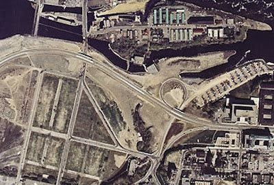
The newly opened Parkway was continuous with Wellington Street, effectively realigning it just west of Bay Street, marking the first realignment of Wellington Street since the Viaduct was built in 1909. However, Wellington remained connected with its former self by a ramp in each direction: the eastbound ramp taking the prior alignment hugging around the Garden of the Provinces park, and a cloverleaf-style offramp connecting Westbound Wellington Street with what is now Cliff Street and connecting up with its previous self at the Fleet Street interchange. This connection provided a route to Hull through LeBreton Flats,32 since the Parkway did no longer intersected with Booth. This aerial photo found at pastottawa.com is one of few shots I could find of this short-lived arrangement:
Closing Britannia Terrace and other streets
In 1971, the NCC applied to the City of Ottawa33 to formally close the roads that had already been removed for the Ottawa River Parkway, i.e. Britannia Terrace,34 Keefer and Baldwin Streets,35 Bronson Avenue north of Wellington Street36 and the easterly portion of Oregon Street, west of Broad Street.37 The map accompanying the City Planning Department's report shows where the new cloverleaf offramp (and what is now Cliff Street) connecting Wellington to itself through LeBreton Flats interacts with the former Baldwin Street and Keefer Street.38
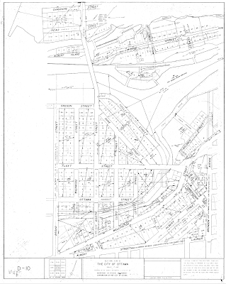
Someone must not have noticed that Britannia Terrace had been renamed to Pooley Street in September 1950 in one of a pair of bulk street renamings following the City of Ottawa's annexation of surrounding areas.39 Curiously, this undated topographic map40 from a folder called "1934-1979" indicates that Pooley Street (ex Britannia Terrace) was legally closed in 1972,34 yet it doesn't show the Ottawa River Parkway built five years earlier!
Chronologically, we've already looked at the next major change to Wellington in Part 8 about the 1969 closure of the Wellington Street Viaduct. Coming up in Part 11, we'll look at the next major adjustment to Wellington Street: the Portage Bridge.
In the event anyone is actually reading these, thanks for your patience as I gradually chip away at each section of this blog series. It takes quite a bit of time to research, compile, assemble, and review them—time that it appears I only have around the start and end of the year! There's a small chance I'll get Part 11 done by the end of January, 2023. As always, I've done my best to filter out the wrong information and provide sources for the rest; corrections are welcome by email, tweet, or comment (all comments are moderated).
Show/hide references
- 1: ▲ "Colour aerial photo of Nepean Bay and LeBreton Flats." Alex Onoszko collection (aerial photography). City of Ottawa Archives, Accessed on 2022-01-13.
- 2: ▲ "A1_73.jpg (1928 aerial photo)." Ottawa-Gatineau imagery (uOttawa Library Cartographic Resources). NCC and City of Ottawa via uOttawa, Accessed on 2020-01-26.
- 3: ▲ Gréber, Jacques. Plan for the National Capital. National Capital Planning Service, Ottawa, 1950, Plate 11.
- 4: ▲ "Journal Photo of Four Cars Abreast on Bridge Has Board Reconsidering 'Laning' of Viaduct." Ottawa Journal, 1950-07-05, pp. 3 Cols 3-5. The article cites Controller Tardif saying that a Federal District road will eventually cross Lazy Bay further north; I think this meant to refer to Nepean Bay since Lazy Bay was much further north.
- 5: ▲ Campbell, Norman and Greg Connolley. "Parliament." Ottawa Citizen, 1960-01-02, pp. 2, Cols. 2-3.
- 6: ▲ "Proposed Causeway Across Nepean Bay." Ottawa Journal, 1960-06-25, p. 31. The photo accompanying the article is credited to Alex Onoszko, with markup by the Journal.
- 7: ▲ Jackson, Richard. "20 Gleaming (Continued From Page One)." Ottawa Journal, 1962-04-19, p. 4.
- 8: ▲▲ Hume, J. A. "10 Govt. Buildings Planned To 'Beautify' Central Area." Ottawa Citizen, 1962-04-19, p. 1.
- 9: ▲ NCC Annual Report (1963-1964), part one. National Capital Commission, 1964, pp. 13-14.
- 10: ▲▲ NCC Annual Report (1964-1965), part one. National Capital Commission, 1965, p. 17.
- 11: ▲ "COA/12D86/CA 8684/Alex Onoszko (via Kitchissippi Times website)." Alex Onoszko collection (aerial photography). City of Ottawa Archives, Accessed on 2019-12-04, November 1962.
- 12: ▲ "Screenshot of 1965 aerial photo with topography overlay." GeoOttawa. City of Ottawa, Accessed on 2022-01-13.
- 13: ▲ "Ottawa 1:1,250 Scale Topographic Maps (1968-1978) Sheet 365-030-2." Ottawa Resource Collection: Historical. Carleton University MacOdrum Library, Accessed on 2019-11-24.
- 14: ▲ Jackson, Richard. "Wellington Viaduct Morning Crush Hour." Ottawa Journal, 1953-11-06, pp. 3, Cols 4-5.
- 15: ▲ Gréber 1950 p. 173.
- 16: ▲ Jackson, Richard. "Gov't Takes Over 150 Acres of 'Flats'." Ottawa Journal, 1962-04-19, pp. 1, Col. 1. Photo is COA/12D86/CA 7689/Alex Onoszko.
- 17: ▲ "The King's Highway 15A (Alt.) Ottawa." The King's Highway. Cameron Bevers, Accessed on 2019-12-22.
- 18: ▲ NCC Annual Report (1961-1962), part one. National Capital Commission, 1962, p. 13.
- 19: ▲▲ Hume, J. A. "$2 Million Set For Rail Move." Ottawa Citizen, 1960-02-15, p. 7.
- 20: ▲ NCC Annual Report (1962-1963), part one. National Capital Commission, 1963, p. 12.
- 21: ▲▲ NCC Annual Report (1963-1964), part one. National Capital Commission, 1964, p. 14.
- 22: ▲ "New East, West, and South Approaches to City: Imposing Program Of Traffic Changes: Eastern Entrance Over New Bridge Spanning The Rideau At Hurdman's." Ottawa Citizen, 1949-04-30, p. 22.
- 23: ▲ Hume, J. A. "Year of achievement for NCC in developing capital." Ottawa Citizen, 1963-12-27, p. 34.
- 24: ▲ "Photo: The Ottawa River Parkway from Parkdale." NCC Annual Report (1963-1964), part one. National Capital Commission, 1964.
- 25: ▲ NCC Annual Report (1964-1965), part one. National Capital Commission, 1965, p. 10.
- 26: ▲ NCC Annual Report (1964-1965), part one. National Capital Commission, 1965, p. 11.
- 27: ▲ NCC Annual Report (1965-1966), part one. National Capital Commission, 1966, p. 14.
- 28: ▲ NCC Annual Report (1965-1966), part one. National Capital Commission, 1966, p. 15.
- 29: ▲ "The Operations Branch." NCC Annual Report (1966-1967), part one. National Capital Commission, 1967, No page numbers in this year's report.
- 30: ▲ NCC Annual Report (1967-1968), part one. National Capital Commission, 1968, p. 15. The OPL only has the French version of this year's NCC annual report.
- 31: ▲ NCC Annual Report (1968-1969), part one. National Capital Commission, 1969, p. 7.
- 32: ▲ "$13 million bridge focus of fight." Ottawa Citizen, 1972-07-21, p. 1.
- 33: ▲ "Bennett seeks all details on cost of NCC services." Ottawa Journal, 1971-11-16, p. 3.
- 34: ▲▲ "By-Law No. 108-72: A By-law of The Corporation of the City of Ottawa stopping up the whole of Britannia Terrace as shown on Registered Plan Number 2." City of Ottawa Bylaws, 1972. City of Ottawa, 1972-05-01, pp. 249-250.
- 35: ▲ "By-Law No. 106-72: A By-law of The Corporation of the City of Ottawa stopping up Firstly the whole of Baldwin Street, formerly Bay Street, lying west of the Road Allowance between Lot 40, Concession A, Ottawa Front, and Concession 'C', Rideau Front; and Secondly the whole of Keefer Street lying south of the production westerly of the southerly boundary of Baldwin Street and north of the northerly boundary of Wellington Street, formerly George Street." City of Ottawa Bylaws, 1972. City of Ottawa, 1972-05-01, pp. 243-245.
- 36: ▲ "By-Law No. 105-72: A By-law of The Corporation of the City of Ottawa stopping up parts of the original road allowance between Lot 40, Concession A, Ottawa Front, and Concession 'C', Rideau Front, lying north of the northerly boundary of Wellington Street, formerly George Street." City of Ottawa Bylaws, 1972. City of Ottawa, 1972-05-01, pp. 241-242. I.e. Bronson Avenue.
- 37: ▲ "By-Law No. 107-72: A By-law of The Corporation of the City of Ottawa stopping up part of Oregon Street described by an instrument registered in the Registry Office for the Registry Division of Ottawa as Instrument Number 238358 and lying to the west of a line drawn parallel to and perpendicularly distant 34 feet westerly of the production northerly of the westerly boundary of Broad Street, as shewn on Registered Plan Number 2 in the said Registry Office." City of Ottawa Bylaws, 1972. City of Ottawa, 1972-05-01, pp. 247-248.
- 38: ▲ "LeBreton Flats - National Capital Commission - Application to close Britannia Terrace, Baldwin Street, Part of Oregon Street West of Broad, Keefer Street, and Part of Bronson Avenue North of Wellington (277-184-65)." City of Ottawa Bylaws, 1971. City of Ottawa, 1971-11-15, p. 3321. On page 3323, the report notes that 'Bronson Avenue is part of the original concession road system therefore application to the Lieutenant Governor in Council is a necessary step in closing this roadway.'.
- 39: ▲ "By-Law No. 212-50: A By-law of the Corporation of the City of Ottawa changing the names of certain streets." City of Ottawa Bylaws, 1950, 1950-10-16, pp. 602-607. By-Law 211-50 pp. 602-604 dealt with street renamings in Carlton and Westboro wards; 212-50 specifically renamed Britannia Terrace to avoid confusion with the new Britannia District, but also updated other street names to legally reflect existing on-the-ground name changes.
- 40: ▲ "Ottawa 1:1,200 Scale Topographic Maps (1934-1979) D-10." Ottawa Resource Collection: Historical. Carleton University MacOdrum Library, Accessed on 2019-11-24, There is a disclaimer on the map that it was compiled from registered plans and not on-the-ground surveys.







Great work! I've been catching up on your blog, and it saves me a lot of trips to the Ottawa Room at the library. ;)
ReplyDelete